DELTAIC ENVIRONMENTS
A delta, in the geographic sense, is a deltoid-shaped area determined by the major bifurcations of a river and resulting from relatively rapid deposition of river-borne sediment into a more or less still standing body of water. The Nile is the type delta. A delta, in the geologic sense, is defined as a deposit of sediment partly subaerial and made by a stream at the place of entrance into a permanent body of water (Barrell, 1912 and Twenhofel, 1939). The major portion of the deltaic sediments is deposited subaqueously in the permanent body of water where waves and currents aid in the transportation and deposition.
The environment of a large delta building into the sea is transitional between the normal marine and continental, and the deposits of each may be expected to interlens with the other.
In exploring deltaic deposits for hydrocarbons, it is necessary to consider the possible types of deltas which may have existed. Very generalized maps of the principal types of the large deltas throughout the world are shown in Figure 20 and Figure 21. Delta types appear to be determined to a large extent by the nature and size of the drainage area controlling the sediment volume, and the hydrography and oceanography of the basin of deposition.
No satisfactory classification of deltas has been established. Tidal-estuarine, arcuate, cuspate, lobate, and birdfoot deltas have been mentioned in the literature (McCurdy, 1947).
Some deltas are composites of several of these types, such as the Mississippi which is a composite of birdfoot, lobate, and cuspate types. The Rhone is a composite arcuate and cuspate delta. The Amu Dar'ya is lobate and cuspate.
Beaches and barrier islands fringe deltaic plains, where littoral currents are strong and waves and tidal ranges are large. The Niger, an arcuate type delta, is an example. Beaches and barriers appear to develop on the flanks of distributaries of many deltas which are building in water bodies with small tidal ranges, relatively large waves, and relatively strong littoral currents. The cuspate Nile Delta is an example. Beaches and barrier islands are relatively uncommon on the margins of deltas which are building in water bodies with small tidal ranges and waves, and weak shore currents. The lobate Lena and the Mississippi birdfoot deltas are examples. Tidal-estuarine deltas are probably deltas in youth and are associated with streams depositing small quantities of sediment in a body of water. The Amazon appears to be an example. The Irrawaddy and the Ganges deltas represent an undescribed type and appear to have resulted from the very rapid deposition of very large amounts of sediment. The waters of these two rivers head in areas of considerable relief which are near the delta.
The Amazon, Me'Kong, and Irrawaddy may represent relative stages of delta maturity. Rivers having large changes in gradient and carrying large sediment loads form "alluvial fan type deltas" in interior drainage basins. The upstream parts of the Amu Dar'ya, the Nile, and also the Colorado of the southwestern United States are examples.
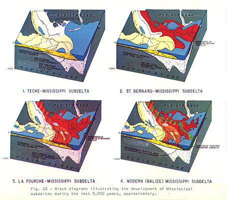
In general, the history and development of the composite Mississippi Delta during the standing sea-level stage is believed to be similar to that of other world deltas. The Mississippi Delta prograded seaward, approximately 125 miles, during the standing sea-level stage (Figure 22). It consists of five major subdeltas: the abandoned Maringouin, Teche, St. Bernard (lobate), LaFourche (cuspate) subdeltas and the modern Mississippi (birdfoot) subdelta. Minor transgressions of the seaward margins of the abandoned subdeltas, such as the Teche and the St. Bernard, occurred recently because of subsidence due to compaction of the soft underlying clays and accompanying wave and current erosion. The future Atchafalaya subdelta should advance seaward over the transgressed portion of the Teche Delta. Thus, the seaward parts of a deltaic complex may be inters ratified with normal marine transgressive deposits consisting of sand, silt, and clay with shells (see Figure 30). The thin transgressive deposits (heavy lines, Figure 22) should produce small electric log markers within a composite over-all regressive sequence of deltaic deposits. Note the thin normal marine transgressive deposits above and below the deltaic sequence of the St. Bernard subdelta (Figure 29). See Kolb and Van Lopik (1958) for the latest summary and interpretation of Mississippi Delta history.
Deltaic Subenvironments and the Mississippi Delta
The subaerial plan of the delta serves to distinguish it from the alluvial environment. The alluvial-deltaic boundary occurs where the river begins to bifurcate and form distributaries. This boundary coincides with the downstream change in river gradient and with the prominent downstream decrease in grain-size ranges.
The subaerial part of the delta is referred to as the deltaic plain and is subdivided into an upper plain containing fresh water deposits and a lower plain containing brackish water deposits. The upper deltaic plain features are similar to those of the lower alluvial plain. The principal morphological features of the deltaic plain are flood basins containing numerous lakes and bays and distributary meander belts and/or straight channels flanked by natural levees (see Figure 23 and EPR Geol. Misc. 17, in preparation).
The offshore subaqueous part of the delta is referred to as the pro deltaic plain environment in which the bulk of deltaic sediments is deposited. It is delineated in part by its topographic form, the delta front bulge, and by nature of its sediments and microfauna. The topographic form of the subaqueous parts of other deltas is not as apparent as that of the Mississippi. The pro deltaic plain environment includes the deltaic plain fringe and deltaic plain distal subenvironments (Figure 23).
The fringe includes the beaches, barrier islands, distributary mouth bars, interdistributary bays, the nondescript delta-front platform, and the uppermost delta front slope. The Mississippi fringe area includes numerous beaches and barriers and extends from the shore to approximately the 60-foot contour.
The area of the distal subenvironment includes the middle and lower delta-front slope and the delta-front toe.
Deltaic Foraminiferal Assemblages
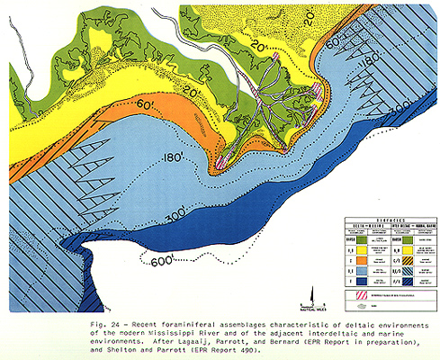
Many distinct benthonic foraminiferal assemblages have been distinguished in the deltaic environment of the Mississippi by Lagaaij, Parrott, and Bernard (report in preparation). The generalized distribution of these assemblages is shown in Figure 24. "Depth" and turbidity appear to be the most important factors in controlling their distributions. The marsh assemblages, shown in green, and the bay and offshore shallow water assemblages, shown in yellow, are quite similar to the marsh and the offshore shallow water assemblages of the adjacent coastal interdeltaic-marine environments. The above authors have found that the deeper water pro deltaic plain assemblages indicated by orange and blue in the figure are quite distinct from, but related to, the normal marine faunal assemblages of similar water depths. The latter are indicated by the diagonal black lines. The mouth bar and distributary channel sands are either barren or contain few reworked Foraminifera. The microfaunal sequence off the delta represents the top-to-bottom faunal sequence expected in a regressive sequence of deltaic sediments, especially for the late Tertiary of the Gulf Coast.
Generalized Deltaic Sediment Distribution
In the flood basins of the deltaic plain, silts and clays predominate. These are transported to the basins during overbank river stages. In most deltas these sediments are inters ratified with peat and contain large amounts of logs, wood, and fine grained plant material. Trees in standing position are very common in many parts of a flood basin. In general the channels are filled in the upper part with fine grained material which grades downward into coarser material (Fisk, et al., 1952). Channel fill deposits, especially those of oxbows, may consist entirely of relatively fine grained material, depending upon the manner of abandonment.
Clean sands are restricted to the channels, beaches, spits, mouth bars, and the very shallow delta platform of the deltaic fringe environment (Figure 25). See Fisk, McFarlan, Kolb, and Wilbert (1954) and EPR MSPR,* August 1955, Item 21004. Such sands are transported by the river as bed load and are deposited in and/or near the river mouth where the fresh river water overrides the denser sea water. Much of this sand is reworked and redeposited in the fringe area when waves are large and currents are strong.
Much silt and clay is deposited in the protected interdistributary bays and lagoons of the deltaic fringe area and in the distal zone. Very little or no sand occurs in the distal zone. The average grain size decreases with water depth and with distance offshore in the pro deltaic plain environment. This is the grain-size sequence expected in a regressive sequence of these deposits.
![]()
*In this report Monthly Summary Progress Report is abbreviated
to MSPR.
![]()
Sedimentary Features Common to Deltaic Deposits
Sedimentary features and their sequential relationships are very important criteria for the recognition of lower deltaic plain and pro deltaic plain environments of deposition (Figure 26). See EPR Memo 16, March 1956b. The data for sedimentary features east of the Mississippi Delta have been taken from Moore and Scruton (1957).
Complete information on the sedimentary features of channel fill deposits is not available. Giant ripple bedded, small ripple bedded, and laminated and interbedded sand, silt, and clay have been observed. Of these features, the laminated and interbedded sands, silts, and clays are most common. The natural levee deposits which flank the channel consist of interbedded, laminated, small ripple bedded, and contorted sand, silt, and clay. These may be oxidized and disturbed since they are exposed to weathering during lower water stages.
Refer to discussion of these deposits under Brazos and Rio Grande deltas which follows.
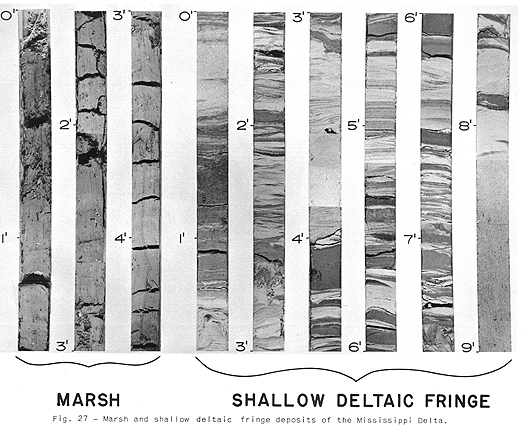
Backmarsh and shallow small lake deposits, shown to the left in Figure 27, consist of massive, disturbed, organic-rich silt-clay. The distribution of these deposits is indicated in green on Figure 26 (see above under sediments).
Most beach and spit, and shallow river mouth bar sands are massive or laminated (Figure 27, core on right 8-9 ft). Cross bedding, small and large, may be common in the bar sands. The occurrence of these sands is indicated in yellow on Figure 26. They are deposited where wave action and currents are relatively strong and continuous. Laminated, small ripple bedded, and interbedded sand, silt, and clay with very few shells occur in the deltaic fringe environment where currents and wave action are weaker (Figure 27), cores from 0-8 ft. The bedding is frequently repetitious and each unit represents either flood stages, storms, or tides. The occurrence of the laminated and interbedded deposits is indicated by the vertical stripes on Figure 26.
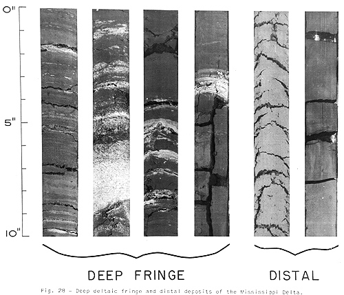
In the deeper waters of the deltaic fringe environment, the silt and clay layers are thicker than the sand layers (Figure 28).
Fecal pellets are frequently found in the fringe environment. The pellets are usually lenticular to cylindrical in shape. They vary in size, but in most cases are under 5 mm in length. They are generally darker than the containing matrix and are often olive-gray in color. The term "turkey tracks" has been used to describe the appearance of these features in the sediment (see core 2, Figure 28). It is believed that these pellets reflect a high rate of organic productivity and suggest a pro deltaic plain environment of deposition.
Massive silt-clays as seen in the two cores on the right of Figure 28 are representative of the distal environment. These clays occur in the area colored brown on Figure 26.
Other Features in the Mississippi Deltaic Area
Sand and clay, burrowed and churned by organisms, occur in the outer fringe and in the coastal interdeltaic-marine and normal marine environments east of the delta where sedimentation is slow and currents are weak. This burrowing and churning prevents the preservation of other sedimentary structures.
The massive sand, shown in orange on Figure 26, east of the delta is of interdeltaic-marine and normal marine margin. It contains numerous shell fragments. Most of this sand was deposited before the delta advanced towards this area and much sand was derived from the reworked upper parts of the St. Bernard Delta to the northwest.
Geometry and Sequence of Sedimentary Features
Mississippi-St. Bernard Subdelta
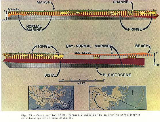
The cross section (Figure 29) across the abandoned St. Bernard Delta illustrates the geometry of a complete regressive sequence of deltaic sediments. See Kolb and Van Lopik (1958) for their interpretation of the St. Bernard section, which is very similar to that in Figure 29. The deposits prograded seaward over a very thin layer of transgressive interdeltaic-marine and normal marine sand, silt, and clay containing abundant shells. The deltaic fringe deposits are indicated by yellow and brown stripes and solid yellow. The well-sorted and usually massive sands are indicated by the solid yellow. The interbedded and laminated fine sand, silt, and clay are indicated by the vertical yellow and brown stripes. They overlie the massive distal pro deltaic plain clays shown in brown. The deltaic fringe deposits are overlain by deltaic marsh deposits indicated by green and are cut by channels and channel fill deposits. The well developed channel fill sands are indicated by the yellow with dots, and the interbedded, laminated, and small ripple bedded channel fill sand, silt, and clay are shown by the vertical yellow and green stripes. The upper parts of the channel fill deposits are finer grained than the lower parts. The well-sorted deltaic fringe sands, shown in light yellow, consist of beach, spit, and mouth bar sands. These zones of sands are blanket-like, not over 35 feet thick, and are continuous for distances of over 8 miles along this section. Since the major portion of this delta was abandoned about 1500 years ago (McFarlan, 1955), the more seaward parts of the delta have been transgressed by bay, marine, and beach deposits which contain abundant shells.
Pleistocene Mississippi-Neptune Delta
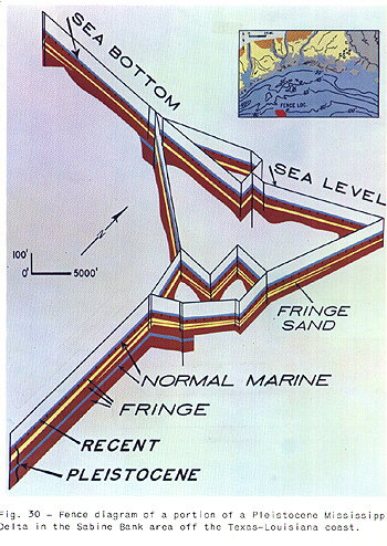
Soil borings located on the Neptune prospect, approximately 65 miles offshore from Galveston, Texas, reveal Pleistocene Mississippi deltaic fringe sediments unconformably overlain by a thin veneer of Recent marine transgressive sands containing abundant shells (Figure 30). Another thin marine shelly sand is inters ratified with the lower deltaic fringe deposits and may record another small transgression. The deltaic fringe sand is shown in yellow. It is 5 to 25 feet thick and occurs throughout the area of the fence, which is about 7 miles square. This sand is blanket-like and its geometry is very similar to the deltaic fringe sands occurring in the cross section of the St. Bernard Delta (Figure 29).
Sequence of Fringe Deposits and SP Log Character
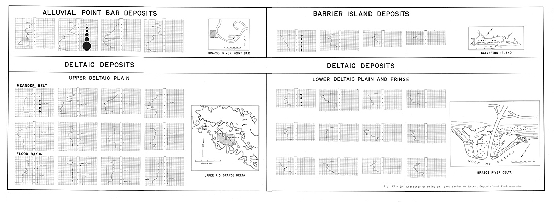
In general, repetitious sequences of sand and shale units in which the sand units increase (and the shale units decrease) in thickness upwards are characteristic of a regressive sequence of deltaic fringe deposits. There is also an upward increase in grain size. The SP curves (Figure 43) represent the fringe deposits of the Brazos River Delta (EPR Geol. Misc. 1, revised May 1958). Note the serrate funnel-shaped character of most of the SP logs, which represents the regressive nature of deltaic fringe sedimentation. Similar logs of fringe deposits were recognized early in 1957 by Parrott et al. in their investigations of the associated foraminiferal assemblages in a section of the Miocene in West Lake Verret field, Louisiana.
Sequence of Channel Fill Deposits and SP Log Character
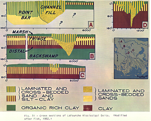
Some of the details of the relationships between distributary channel fill and pro deltaic plain deposits of the LaFourche Delta may be seen (Figure 31) in borings published by Fisk et al. (1952). The top-to-bottom sequence of backswamp or marsh deposits overlying deltaic fringe and distal deposits is quite evident. These are cut by channel and channel fill deposits which become finer grained upwards. Only a very few SP logs of actual channel fill deposits have been made recently. The logs have been compared with continually cored sections. Based upon these logs and the manner of channel abandonment, the SP character of these deposits should be serrate, serrate-bell, or serrate pot-belly in character. The SP character of many sections follows the shale line. The backswamp deposits (shown in green) in the lower parts of Sections A and B were deposited during the earlier rising or standing sea-level stages.
Sequence of Deltaic Point Bar and Other Deposits
The SP log character of known deltaic point bar and other deposits follows in the text on the Brazos and Rio Grande deltas.
Fisk et al. (1954) believe that thick fingers of mouth bar "sands" develop in a large birdfoot delta building in deep water. According to Fisk, subsidence of the mouth bar deposit in soft pro deltaic plain clay, as the distributary mouth advances seaward, accounts for the relatively thick bar finger deposits consisting largely of sand and silt. Approximately 100 feet of subsidence is required to produce a thickness of 200 feet of bar finger sand. Fisk diagrammatically shows over 200 feet of bar "sand" for the section at Southwest Pass, but borings made by Shell record sand thicknesses of only 70 feet. Our calculations of subsidence for this section based upon the thickness of marsh deposits and depths of faunal assemblages are not over 35 or 40 feet. See EPR Geol. Misc. 17, 1957 and revised 1958 ( in preparation) .
Odem (1953) and Nienaber (1958) have studied the historical development, geometry, and sediments of the new Brazos subdelta.
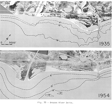
Data on hand suggest that subdivisions of the pro deltaic plain environments of other types of deltas are somewhat similar to those of the Mississippi birdfoot delta. However, the detailed nature of the associated facies of other deltas should be slightly different from that of the Mississippi. A cuspate portion of the more recent Brazos Delta is shown in Figure 33. Only a few samples of cores from the shallow water deltaic fringe environment of the Brazos are available for comparison with those of the Mississippi. However, cores of the deeper water deltaic fringe and the distal environments of the Brazes are similar to those of the Mississippi.
The faunal assemblages are similar to those of the shallow water environment of the Mississippi Delta. The populations are also sparse, but reworked species are more common.
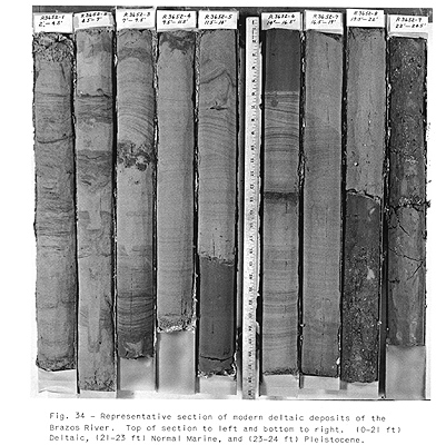
Recently obtained cores which illustrate the sequence of Brazos pro deltaic plain deposits are shown in Figure 34. Repetitious units of fringe sand and silt grading upward into silt and clay, representing floods and storm and tide currents, are similar to those of the Mississippi. The frequent increase in thickness of the sandy parts of these units upwards in the section and the corresponding decrease in thickness of the silt and clay represent an offlap sequence of deltaic fringe deposits. These are indicated on the SP log by a serrated funnel-shaped character. See EPR Geol. Misc. 1, revised 1958.
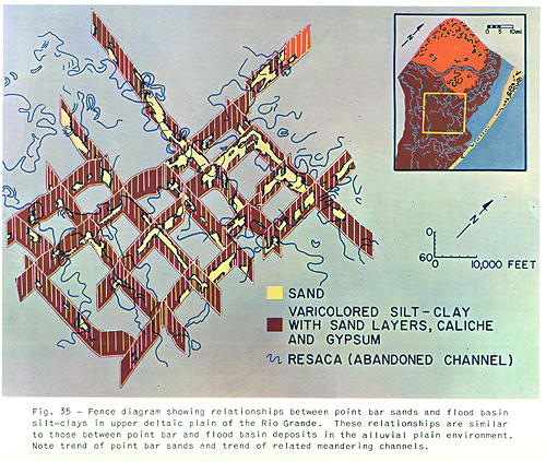
Meander Belt. The distributaries of the Brazos Delta and also those of the Rio Grande Delta continue to meander to the shore. It is believed that the well-developed and continuous beaches along the shore cause the distributaries to maintain a gradient favorable for meandering. The deltaic point bar sands of the Rio Grande are lenticular and average 30 to 45 feet thick (Figure 35). Point bar sands of mature meander belts of the Rio Grande and the Brazos River are from 1 1/2 to 2 miles wide. The trends follow the present meander belts and are approximately at right angles to the shoreline.
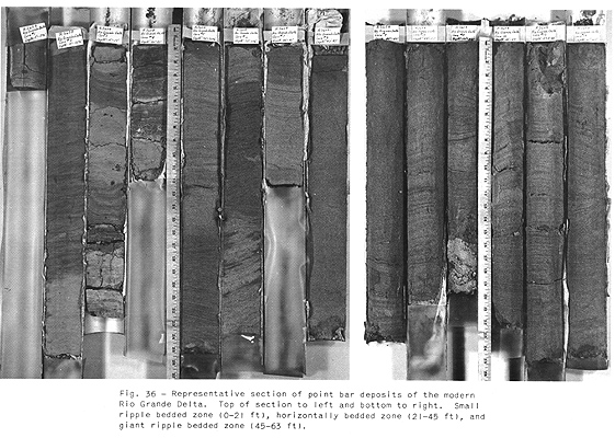
The point bar sequence in the deltaic plain environment is very similar to that of the alluvial environment except for the maximum grain size and the range in grain size with depth (see EPR Geol. Misc. 1, revised May 1958) (Figure 36). The top of the sequence is to the left of the figure and the bottom is to the right. The finest grain sizes occur in the uppermost deposits. The middle and lower point bar deposits of the Rio Grande distributaries are approximately equal in grain size, and the sands are well to very well sorted. The bedding sequence downward grades from small ripple bedded to horizontally bedded and giant ripple bedded sands. Poorly bedded gravel deposits do not occur in over 200 borings in the point bar deposits of the Rio Grande Delta. However, plentiful gravel is available to the alluvial sections of the stream less than 30 miles distant. A small decrease in sand size with depth and the absence of a basal gravel zone in point bar deposits appear to be indicative of a deltaic plain environment. Dependent upon the geological framework, it should be possible for deltaic distributaries to deposit gravel.
Flood Basin. The flood basin silt-clay deposits of the Rio Grande Delta are varicolored and mottled and contain caliche nodules and gypsum (see Figure 35). Lime nodules are also common in flood basin deposits of the Colorado, Brazos, Trinity, and Mississippi deltas.
Wood and Fauna. It appears that most deltaic plain deposits, except for those in arid climates, contain abundant wood with many logs in standing position and numerous peat or coal beds. Reworked faunas may be common.
Sequences and SP Log Character. The SP curves of the point bar sequence in the upper deltaic plain of the Rio Grande are very similar to those of the alluvial plain environment (EPR Geol. Misc. 1, revised May 1958). They are either bell, serrate-bell, or block-like in shape with an abrupt deflection toward the shale line at the bottom and a gradual tapering toward the shale line near the top (Figure 43). The flood basin silts and clays are recorded on the SP log by a gentle deflection near the shale line (Figure 43). Other facies recognized on the SP logs in the Rio Grande Delta are those of abandoned distributary channels and natural levee deposits (Figure 43).
![]()
*In this report Monthly Summary Progress Report is abbreviated to MSPR.
![]()