![]() Click to view article in PDF format.
Click to view article in PDF format.
GCWaveform Classification Proves Itself a Valuable Tool*
Satinder Chopra1
Search and Discovery Article #41065 (2012)
Posted November 30, 2012
*Adapted from the Geophysical Corner column, prepared by the author, in AAPG Explorer, November, 2012. Editor of Geophysical Corner is Satinder Chopra ([email protected]). Managing Editor of AAPG Explorer is Vern Stefanic; Larry Nation is Communications Director. AAPG©2012
1 Arcis Corp., Calgary, Canada ([email protected])
The shape and character of the ![]() seismic
seismic![]() waveform is often used to characterize reservoir quality. This is because the
waveform is often used to characterize reservoir quality. This is because the ![]() seismic
seismic![]() waveform carries information about the phase, frequency and amplitude - and any variation in these parameters is considered reflective of the lateral variations in lithology, porosity and fluid content.
waveform carries information about the phase, frequency and amplitude - and any variation in these parameters is considered reflective of the lateral variations in lithology, porosity and fluid content.
If the shape and character of ![]() seismic
seismic![]() waveforms in a given target zone can be studied using some pattern recognition type of a process, and then displayed in a map view, the
waveforms in a given target zone can be studied using some pattern recognition type of a process, and then displayed in a map view, the ![]() display
display![]() would indicate
would indicate ![]() seismic
seismic![]() facies variation at the target level.
facies variation at the target level.
One approach to pattern recognition is with the use of neural networks to compare ![]() seismic
seismic![]() waveforms and group them into different classes. Under this approach two types of methods could be distinguished, namely unsupervised and supervised classifications. In the unsupervised method - apart from defining an analysis interval - no other a priori information is used for the classification of
waveforms and group them into different classes. Under this approach two types of methods could be distinguished, namely unsupervised and supervised classifications. In the unsupervised method - apart from defining an analysis interval - no other a priori information is used for the classification of ![]() seismic
seismic![]() traces into groups or classes. The supervised method uses the known information available at specific well locations for the classification process. In this article, we discuss the unsupervised approach.
traces into groups or classes. The supervised method uses the known information available at specific well locations for the classification process. In this article, we discuss the unsupervised approach.
|
|
There are two steps to the process in the unsupervised classification:
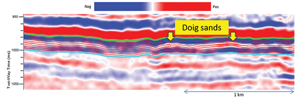
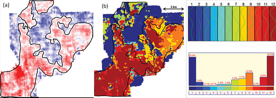
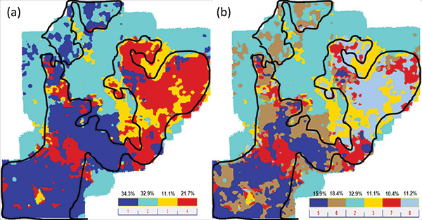
The resulting map is essentially a facies map, which itself is essentially a similarity map of the actual traces to the different synthetic traces. The Once a Western Canada's Middle Triassic Doig Formation is composed of argillaceous siltstone and calcareous shale. It is uncomformably overlain by the Halfway Formation and itself overlays the Montney Formation. It is seen to occur in northwestern Alberta, northeastern British Columbia and southern Yukon provinces of Canada. While the maximum thickness of the Doig Formation reaches over 180 meters in the foothills of the Rocky Mountains, it thins out to the north and the east. Within the Doig Formation, thick sandstone bodies occur within the shale, and many of them are found to be economic hydrocarbon reservoirs - hence the attraction for their exploration and development. Examination of the available core from the Doig sandstone reservoirs suggests an association between sedimentary facies such as shoreface, offshore transition and offshore/shelf. Phosphates and other accessory minerals in the Doig sandstone bodies can drive the gamma ray tool response and mask the sands, so correct identification of the bodies on logs requires multiple curves. The facies change quickly in both the vertical and the horizontal directions. Recognition of these facies changes and characterization of the Doig sandstones serves as a useful input for exploration and development purposes. In Figure 1 we show a segment of a Next, to study the facies variation exhibited by the sandstone, the upper horizon (in green) was tracked as the zero crossing event. For selecting the interval covering the For performing waveform classification, the a priori specification of the number of desired classes was chosen as 12. The different classes with their color codes are shown in the inset next to Figure 2b, and the shapes of the individual waveforms in the inset above. Notice, the facies map in Figure 2b shows a variation in terms of the colors, but the overall facies pattern seems to follow the sand boundary overlaid on it. Realizing that the number of classes chosen may not have yielded an optimum facies variation, we next decided to adopt the hierarchical waveform classification. We begin with four classes and the facies variation is shown in Figure 3a. On this
I thank James Keay for useful discussions with regards to the geological description of the Doig sands, and I also thank Arcis |
 General statement