![]() Click
to article in PDF format.
Click
to article in PDF format.
GCHorizon Tracking on Workstations*
By
Les Denham1 and Dave Agarwal1
Search and Discovery Article #40141 (2005)
Posted February 6, 2005
*Adapted from the Geophysical Corner column in AAPG Explorer, November, 2004, entitled "Track Geology in Greater Detail” and prepared by the authors. Appreciation is expressed to the authors, to Alistar R. Brown, editor of Geophysical Corner, and to Larry Nation, AAPG Communications Director, for their support of this online version.
1Interactive Interpretation and Training, Houston, Texas ([email protected]; dave@[email protected])
Before seismic interpretation workstations, interpreters marked paper sections with each horizon, then laboriously read off the time of the reflection -- usually to no better than ±5 ms -- and at intervals of perhaps every tenth trace. Computers, however, remember exactly where the interpreter picks -- and often pick more accurately. Autotracking on lines in either 2-D or 3-D data, and through a volume in 3-D, picks with precision on every trace, so machine horizon tracking today can reveal geology in greater detail than manual interpretation can ever achieve.
|
uGeneral statementuFigure captionsuInterpretationuAutomatic trackinguAlternativeuConclusion
uGeneral statementuFigure captionsuInterpretationuAutomatic trackinguAlternativeuConclusion
uGeneral statementuFigure captionsuInterpretationuAutomatic trackinguAlternativeuConclusion
uGeneral statementuFigure captionsuInterpretationuAutomatic trackinguAlternativeuConclusion
uGeneral statementuFigure captionsuInterpretationuAutomatic trackinguAlternativeuConclusion
|
Interpretation (Correlation): Decisions and ParametersThe first decision is what seismic event to pick. Figure 1 shows a geological marker in two wells; a continuous reflection approximately ties the two markers, but in one well the marker is on a positive-to-negative zero crossing, while it is close to a peak in the second well. A synthetic seismogram might help, but that is beyond the scope of this article. Often the interpreter can simply decide on a continuous event to pick close to the marker to be mapped.
Most
reflections are composite; the perfect Any interpretation system has parameters that can be set to specify the way in which the correlation from trace to trace is done. These may include:
If the parameters are too restrictive, the tracking leaves gaps. If the parameters are too loose, it makes mistakes.
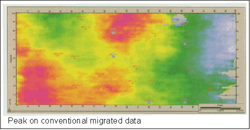
Automatic Tracking for 3-D Data For 3-D data, automatic tracking from one trace to the next can be extended throughout the data volume. Figure 2 shows the result of automatic picking of the peak. Where the event mapped becomes less obvious, the automatic picking breaks down.
The
conventional seismic data may not give the most accurate picture of
geological structure when you pick on a constant
A more
elegant attribute is cosine of instantaneous Workstations interpolate between samples using a spline function, so the peak or zero-crossing is picked with a much greater precision than the sample interval (two meters in this data). This difference between the two horizons is real. Automatic tracking is at least an order of magnitude more accurate than manual picking; such a small time difference would never be detected with manual timing. Along with the structure map, we can get a reflection amplitude map, either trace amplitude or the reflection magnitude. Reflection amplitude measurements are impractical with manual picking.
With the
cosine-of-
The
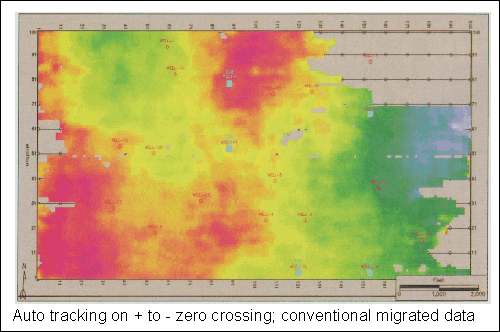
results vary with which point on the reflection is used for picking. In
this example, automatic picking fails over a larger area if the
positive-to-negative zero crossing is used on the conventional data
(Figure 5). There are fewer gaps with cosine-of-
Alternative to Automatic TrackingFor 3-D, an alternative to automatic tracking is to pick manually a subset of the data, then interpolate. This is particularly attractive if automatic tracking is unreliable because the event is weak or the horizon is extensively faulted. In this case the steps to producing both a structure map and an amplitude map are:
This alternative technique can be used over the whole of a 3-D survey or only over parts where automatic picking is unreliable and the results merged with automatic picking in areas where that technique is reliable.
Automatic tracking of seismic horizons in good quality data from a few seed points is a powerful tool for rapidly completing interpretation of 3-D seismic data volumes. It reveals geology with much greater precision and detail than manual interpretation can. However, there are pitfalls in its use; it is less than reliable unless the interpreter understands the geology and restricts the automatic picking by using parameters chosen to minimize mis-picking. Interpolation is often a good alternative for 3-D if automatic tracking will not work reliably
|


