|
Figure Captions
Return to top.
 Interpretation Interpretation (Correlation): Decisions
and Parameters (Correlation): Decisions
and Parameters
The first
decision is what seismic event to pick. Figure 1 shows a geological
marker in two wells; a continuous reflection approximately ties the two
markers, but in one well the marker is on a positive-to-negative zero
crossing, while it is close to a peak in the second well. A synthetic
seismogram might help, but that is beyond the scope of this article.
Often the interpreter can simply decide on a continuous event to pick
close to the marker to be mapped.
Most
reflections are composite; the perfect phase point to pick is uncertain.
All interpretation systems can "snap" to, or follow, maximum negative,
maximum positive or zero crossings (going negative with increasing time,
and going positive). In Figure 1 the reflection is picked on the peak of
an event, and on the positive-to-negative zero crossing. Each horizon is
an automatic track along a line from a single seed point on one trace.
Any
interpretation system has parameters that can be set to specify the way
in which the correlation from trace to trace is done. These may include:
-
Maximum time (or
depth) change from one trace to the next.
-
Whether to pick the
largest event within this limit, or the closest.
-
Maximum amplitude
change from one trace to the next.
-
Whether to follow an
event, or to cross-correlate.
If the
parameters are too restrictive, the tracking leaves gaps. If the
parameters are too loose, it makes mistakes.
Automatic Tracking for 3-D Data
For 3-D
data, automatic tracking from one trace to the next can be extended
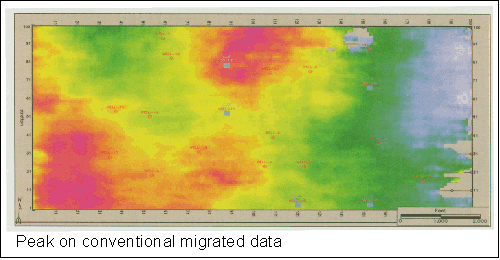
throughout the data volume. Figure 2 shows the result of automatic
picking of the peak. Where the event mapped becomes less obvious, the
automatic picking breaks down.
The
conventional seismic data may not give the most accurate picture of
geological structure when you pick on a constant phase point (peak,
trough or zero crossing), especially if the reflection is weak. Seismic
attributes allow removing the amplitude information to make all
reflections the same. The instantaneous phase attribute does this, but
is discontinuous where the phase passes 180 degrees (it jumps to -180
degrees).
A more
elegant attribute is cosine of instantaneous phase, which is -1.0 for
both 180 degrees and -180 degrees (Figure 3). Notice there are
differences of up to 1.1 meters (1.5 meters, or five feet -- a
significant depth error in many prospects) between the two tracked
horizons -- green (picked on conventional data) and red (picked on
cosine-of-phase).
Workstations interpolate between samples using a spline function, so the
peak or zero-crossing is picked with a much greater precision than the
sample interval (two meters in this data). This difference between the
two horizons is real. Automatic tracking is at least an order of
magnitude more accurate than manual picking; such a small time
difference would never be detected with manual timing.
Along with
the structure map, we can get a reflection amplitude map, either trace
amplitude or the reflection magnitude. Reflection amplitude measurements
are impractical with manual picking.
With the
cosine-of-phase data volume, details differ (compare
Figure 4 and Figure
2). Either of these maps show an excellent picture of the structure in
most places, and we have achieved it by manually identifying the event
on one trace only.
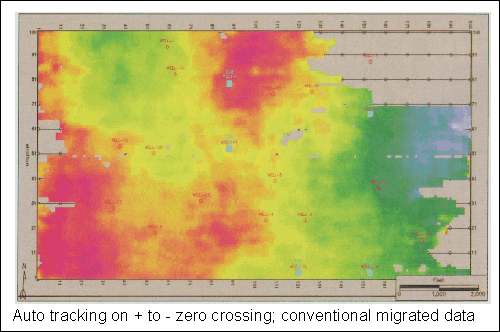
The
results vary with which point on the reflection is used for picking. In
this example, automatic picking fails over a larger area if the
positive-to-negative zero crossing is used on the conventional data
(Figure 5). There are fewer gaps with cosine-of-phase (Figure 6), but
there are obvious errors in several areas.
For 3-D,
an alternative to automatic tracking is to pick manually a subset of the
data, then interpolate. This is particularly attractive if automatic
tracking is unreliable because the event is weak or the horizon is
extensively faulted. In this case the steps to producing both a
structure map and an amplitude map are:
-
Manually pick a
subset of the data, such as every tenth line and crossline, by
displaying the lines on the screen and picking exactly where you
want the horizon, using automatic tracking along the line, or
point-to-point interpretation.
-
Interpolate between
the picked lines.
-
Snap to a peak,
trough or zero crossing.
-
Smooth if needed.
-
Map and extract
amplitudes.
This
alternative technique can be used over the whole of a 3-D survey or only
over parts where automatic picking is unreliable and the results merged
with automatic picking in areas where that technique is reliable.
Concluding Comments
Automatic
tracking of seismic horizons in good quality data from a few seed points
is a powerful tool for rapidly completing interpretation of 3-D seismic
data volumes. It reveals geology with much greater precision and detail
than manual interpretation can.
However,
there are pitfalls in its use; it is less than reliable unless the
interpreter understands the geology and restricts the automatic picking
by using parameters chosen to minimize mis-picking. Interpolation is
often a good alternative for 3-D if automatic tracking will not work
reliably if automatic tracking will not work
reliably
Return to top.
|


