![]() Click to view article in PDF format.
Click to view article in PDF format.
Framework for the Exploration of Libya: An Illustrated Summary
Compiled by
Jingyao Gong1
Search and Discovery Article #10061 (2004)
1AAPG/Datapages, Inc., Tulsa, Oklahoma ([email protected])
General Statement
Recoverable reserves being produced in Libya, from more than 300 fields, exceed 50 billion barrels of oil and 40 trillion cubic feet of gas (Rusk, 2001, 2002). Even so, the Sirte (Sirt), Ghadamis, Murzuq, and Tripolitania basins (Figure 1) are yet to reach full maturity in exploration. Of the 24 giant fields, 20 were discovered prior to 1970. Deep plays are expected to be a large part of upcoming exploration efforts.
Rusk (2001. 2002), in describing the petroleum potential of the centers of Libyan basins, summarized very well the petroleum systems and plays in six basin-center sectors (Figures 1, 2, 3, and 4). This compilation uses the Rusk article as the foundation for presenting several other published maps, cross-sections, and a database, as well as some images in his article; together these should add to the working tool kit for those interested in exploration of Libya.
Maps presented here are in JPEG and PDF formats; for those interested in GIS applications, an expanded version, an atlas, has been prepared for GIS-UDRIL sponsors and other purchasers of AAPG digital products. In the expanded version, approximately 80 georeferenced maps show tectonic features, structural elements and their configuration, thicknesses and facies of key strata and reservoirs, and oil and gas fields, with links to databases and to other images.
The database of giant Libyan fields is from M.K. Horn (2003) in AAPG Memoir 78, Giant Oil and Gas Fields of the Decade 1990-1999. Other information is from various AAPG publications as well as Journal of Petroleum Geology (see Selected Bibliography).
The basin-center sectors in which significant petroleum systems have developed (Rusk, 2001, 2002) are:
Sirte Basin (Figure 2)
South Ajdabiya Trough
Maradah Graben
Southern Zallah Trough – Tumayam Trough
Ghadamis Basin (Figure 3)
Murzuq Basin (Figure 3)
Eastern Tripolitania Basin (Figure 4)
|
|
Sirte BasinCommon features of the three underexplored elements of the Sirte Basin (Figure 2) are:
South Ajdabiya TroughThe underexplored parts of the Ajdabiya Trough cover 8500 km2. In addition to the Sirte-Rachmat Shale (Campanian-Coniacian in age), the Cenomanian-Turonian Etel Formation is an effective source rock, and the Lower Cretaceous lacustrine to lagoonal shale in the Nubian (Sarir) section probably should be considered a minor source (Figure 5). Reservoirs include the Nubian sandstones and Paleocene Lower and Upper Sabil carbonates.
Maradah GrabenThe underexplored part of Maradah Graben is 10,000 km2 in areal extent. The Sirte-Rachmat Shale and the Etel Formation are the known source rocks in this sector (Figure 5). Important reservoirs are the Nubian sandstones, carbonates of the Zelten Formation (equivalent to the Sabil), and Upper Cretaceous Bahi Sandstone, overlying the Nubian.
Southern Zallah Trough – Tumajam TroughThese troughs in the southern to southwestern part of the Sirte Basin contain 25,000 km2 that are underexplored. The Sirte-Rachmat Shale is the known source rock of this area (Figure 5). Nubian sandstones and the commonly indistinguishable Bahi Sandstone are important reservoirs, along with Paleocene Defa and Beda and lower Eocene Facha limestones. Also, as potential reservoirs are Upper Cretaceous sandstones in the Sirte-Rachmat interval.
Central Ghadamis BasinThe basin-center sector encompasses more than 20,000 km2. Two very good source rocks are distributed throughout the entire basin: Lower Silurian Tanezzuft and Middle to Upper Devonian Uennin formations (Figure 6). The main reservoirs are the Upper Silurian Acacus and the Lower Devonian Tadrart and Kasa formations. Three other objectives are the Middle Devonian Uennin Sandstone, Upper Devonian Tahara Formation, and the Triassic Ras Hamia Formation.
Central Murzuq BasinIn this area of more than 30,000 km2, up to the year 2000 only four wells had been drilled. In the area to the north, where oil reserves are some 1 billion barrels, the reservoirs are the sandstones of the Ordovician Memouniat Formation (Figure 6). The documented source rock is the Tanezzuft Shale, although some oil may have been sourced from the Uennin Shale. The potential reservoirs include the Acacus and Tadrart-Kasa sandstones, as well as the Memouniat.
Eastern Tripolitania BasinThis offshore basin, which is a highly faulted, deep trough, extends from the Gulf of Gabes to the northwestern margin of the Sirte Basin. The eastern sector is some 20,000 km2 in extent and is essentially unexplored, with only one dry hole (up to the year 2000); known accumulations are 100-150 km west of the area. Source rocks include the Turonian Bahloul limestone, Necomian-Cenomanian Sidi Kralif – Fahdene shales, Silurian Tanezzuft Shale (in the southwesternmost part), and lower Eocene Chouabine Limestone (in the western part) (Figure 7). Potential reservoirs are (1) limestone comprising the lower Eocene El Garia Formation (of the Metlaoui Group), the main pay in the basin, (2) the Jirani and Bilal carbonates, the equivalent of, or underlying, the El Garia, (3) carbonates of the Alagah and Makhabaz formations (or Lidam-Argub) (Cenomanian-Turonian), and (4) marine sandstones and rudist carbonates of the Lower Cretaceous Turghat-Kiklah sequence.
Table 1
Giant FieldsThe giant fields in Libya (Horn, 2003) are listed below according to basin; the database of selected features of these fields, prepared by M.K. Horn (2003), is presented in Table 1.
Ghadamis Basin Al Wafa
Murzuk BasinElephant
Tripolitania BasinBouri
Figure 8-19
Selected Sirte Basin FieldsProducing reservoirs in the giant fields of the Sirte Basin range from Precambrian basement (igneous rocks) to Oligocene sands. Fracture porosity is important not only in the basement rocks but also in Cambro-Ordovician sandstone at Amal field. Pre-Upper Cretaceous sandstones are important reservoirs in the Sarir, Messlah, Bu Attifel, and Masrab fields. Paleocene and Upper Cretaceous carbonates are the main reservoirs in the other Sirte Basin giant fields. The primary trap in the giant fields ranges from anticline (the most common type), nose, and fault block, to reef and wedge-out/truncation (Horn, 2003). Together, they reflect the tectonic history of the basin, with Mesozoic pre-graben arching, pre-Late Cretaceous faulting and nonmarine sedimentation, Late Cretaceous graben development, represented by several arms, and, to a less extent, Eocene-Neogene sag (Harding, 1984) (Figure 8). Below are sketch-like summaries of fields that together are fairly representative of the range of features the giant fields possess.
Amal Field (Figures 2, 9, and 10) Amal Field is on a north-northwest plunging nose, locally with more than 100 feet of closure at the Rakb (Upper Cretaceous) level. The nose is bounded by major platform/trough-bounding faults. The field is some 30 miles long and 10 miles wide. The main reservoirs are the Cambro-Ordovician Amal Formation, with its fractured quartzose sandstone, and the transgressive-marine sandstones of the Maragh Formation, probably Late Cretaceous in age.
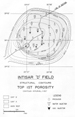
Intisar D Field (Figures 2, 11, 12, and 13) Intisar D Field is one of five productive Paleocene pinnacle reefs that grew in an embayment bounded by three carbonate banks (Brady et al., 1980). It is approximately three miles in diameter. The reef consists largely of corals and algae, with grain- and mud-supported skeletal carbonates. Reef development was responsible for the spectacular reservoir (with 22% porosity) and trap (with 995-foot oil column).
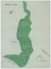
Messlah (Messla) Field (Figures 2, 14, 15, 16, and 17) Messlah field, more than 25 miles long and 5 miles wide, is a stratigraphic trap located on the east flank of a broad Precambrian basement high (Clifford et al., 1980). The reservoir is Lower Cretaceous fluvial Sarir (Nubian) Sandstone, which wedges-out to the west onto the basement. It is truncated by the widespread unconformity at the base of the Upper Cretaceous section. It is similar in type and size to East Texas Field.
Nasser (Zelten) Field (Figures 2, 18, and 19) Nasser Field produces from highly porous Paleocene-Eocene limestone in a faulted anticline that borders the Maradah Graben. The field is more than 16 miles long (parallel to the fault) and 9 miles wide. The Paleocene Zelten “Member,” which is the main pay, experienced porosity enhancement due to groundwater leaching, and secondary porosity as high as 40% has been reported from three skeletal grain-supported shelf limestone facies (Bebout and Pendexter, 1975). These limestones characterized deposition on the platforms separating the arms of the Sirte Graben during some of the Late Cretaceous and much of the Paleocene, while deeper-water deposits characterized the troughs. During the sag phase, Eocene carbonates extended across trough and platform alike.
References and Source Documents for GIS AtlasAl-Shaieb, Z., and J.W. Shelton, 1978, Secondary ferroan dolomite rhombs in oil reservoirs, Chadra sands, Gialo field, Libya: AAPG Bulletin, v. 62, p. 463-468. Ambrose, G., 2000, The geology and hydrocarbon habitat of the Sarir Sandstone, SE Sirt basin, Libya: Journal of Petroleum Geology, v. 23, p. 165-191. Bishop, W.F., 1975, Geology of Tunisia and adjacent parts of Algeria and Libya: AAPG Bulletin, v. 59, no. 3, p. 413-450. Bishop, W.F., 1988, Petroleum geology of east-central Tunisia: AAPG Bulletin, v. 72, p. 1033-1058. Bishop, W.F., and G. Debono, 1996, The hydrocarbon geology of southern offshore Malta and surrounding regions: Journal of Petroleum Geology, v. 19, p. 129 - 160. Bebout, D. and C. Pendexter, 1975, Secondary carbonate porosity as related to Early Tertiary depositional facies, Zelten Field, Libya: AAPG Bulletin, v.59, no.4, p. 665-693. Brady, T.J., N.D.J. Campbell, and C.E. Maher, 1980, Intisar 'D' Oil Field, Libya, in M.T. Halbouty, ed., Giant oil and gas fields of the decade, 1968-1978: AAPG Memoir 30, p. 543-564. Brennan, Philip, 1992, Raguba Field; Libya, Sirte Basin, in E.A. Beaumont and N.H. Foster, eds., AAPG treatise of petroleum geology, Atlas of oil and gas fields: Structural traps, v. 7, p. 267-289. Clifford, H.J., R. Grund, and H. Musrati, 1980, Geology of a stratigraphic giant: Messla Oil Field, Libya, in M.T. Halbouty, ed., Giant oil and gas fields of the decade: 1968-1978: AAPG Memoir 30, p. 507-524. Conant, L.C. and G.H. Goudarzi, 1967, Stratigraphic and tectonic framework of Libya: AAPG Bulletin, v. 51, p. 719-730.Goudarzi, G.H., 1970, Geology and mineral resources of Libya--A reconnaissance: U.S. Geological Survey Professional Paper 660, 104 p., 13 plates. Gumati, Y.D., and W.H. Kanes, 1985, Early Tertiary subsidence and sedimentary facies--northern Sirte Basin, Libya: AAPG Bulletin, v. 69, p. 39-52. Gumati, Y.D., W.H. Kanes, and S. Schamel, 1996, An evaluation of the hydrocarbon potential of the sedimentary basins of Libya: Journal of Petroleum Geology, v. 19, p. 95-112. Harding, T.P., 1984, Graben hydrocarbon occurrences and structural style: AAPG Bulletin, v. 68, p. 333 - 362. Horn, M.K. 2003, Giant fields, 1868-2003 (CD-ROM), in M.T. Halbouty, ed., Giant oil and gas fields of the decade 1990-1999: AAPG Memoir 78. Lewis, C.J., 1990, Sarir Field, in E.A. Beaumont and N.H. Foster, eds., AAPG Treatise of petroleum geology, Atlas of oil and gas fields: Structural traps, v. 2, p. 253-267. Roberts, R.M., 1970, Amal Field, Libya, in M.T. Halbouty, ed., Geology of giant petroleum fields: AAPG Memoir 14, p. 438-448. Rusk, D.C., 2001, Libya: Petroleum potential of the underexplored basin centers - A twenty-first-century challenge: AAPG Memoir 74, p. 429-452. Rusk, D. C., 2002, Libya: Petroleum potential of the underexplored basin centers - A twenty-first-century challenge: Search and Discovery Article #10025 (2002) (www.searchanddiscovery.net). Sanford, R. M., 1970, Sarir Oil Field, Libya--Desert surprise, in M.T. Halbouty, ed., Geology of giant petroleum fields: AAPG Memoir 14, p. 449-476. Terry, C.E., and J.J. Williams, 1969, The Idris “A” bioherm and oilfield, Sirte Basin, Libya; Its commercial development, regional Palaeocene geologic setting and stratigraphy, in The exploration for petroleum in Europe and Nortrh Africa: London, Institute Petroleum, p. 31-48. Williams, J.J., 1972, Augila Field Libya: Depositional environment and diagenesis of sedimentary reservoir and description of igneous reservoir, in Stratigraphic Oil and gas fields--Classification, exploration methods and case histories: AAPG Memoir 16, p. 623-632.
References in Rusk (2001, 2002) Abdulghader, G.S., 1996, Depositional environment and diagenetic history of the Maragh formation, NE Sirt Basin, Libya, in M.J. Salem, A.S. El-Hawat, and A.M. Sbeta, eds., Geology of the Sirt Basin: Amsterdam, Elsevier, v. 2, p. 263–274. Anketell, J.M., 1996, Structural history of the Sirt Basin and its relationships to the Sabratah Basin and Cyrenaican platform, northern Libya, in M.J. Salem, A.S. El-Hawat, and A.M. Sbeta, eds., Geology of the Sirt Basin: Amsterdam, Elsevier, v. 3, p. 57–88. Baird, D.W., R.M. Aburawi, and N.J.L. Bailey, 1996, Geohistory and petroleum in the central Sirt Basin, in M.J. Salem, A.S. El-Hawat, and A.M. Sbeta, eds., Geology of the Sirt Basin: Amsterdam, Elsevier, v. 3, p. 3–56. Bailey, H.W., G. Dungworth, M. Hardy, D. Scull, and R.D. Vaughan, 1989,A fresh approach to the Metlaoui: Actes de IIeme Journees de Géologie Tunisienne Appliquée à la Recherche des Hydrocarbures: Memoire de Enterprise Tunisienne d’Activités Petrólières 3, p. 281–308. Baric, G., D. Spanic, and M. Maricic, 1996, Geochemical characterization of source rocks in NC 157 block (Zaltan platform), Sirt Basin, in M.J. Salem, A.S. El-Hawat, and A.M. Sbeta, eds., Geology of the Sirt Basin: Amsterdam, Elsevier, v. 2, p. 541–553. Barr, F.T., and A.A. Weegar, 1972, Stratigraphic nomenclature of the Sirte Basin, Libya: Petroleum Exploration Society of Libya, 179 p. Belhaj, F., 1996, Paleozoic and Mesozoic stratigraphy of eastern Ghadamis and western Sirt Basins, in M.J. Salem, A.S. El-Hawat, and A.M. Sbeta, eds., Geology of the Sirt Basin: Amsterdam, Elsevier, v. 1, p. 57–96. Bellini, E., and D. Massa, 1980, A stratigraphic contribution to the Palaeozoic of the southern basins of Libya, in M.J. Salem and M.T. Busrewil, eds., Geology of Libya: London, Academic Press, p. 3–56. Bernasconi, A., G. Poliani, and A. Dakshe, 1991, Sedimentology, petrography and diagenesis of Metlaoui Group in the offshore northwest of Tripoli, in M.J. Salem and M.N. Belaid, eds., The Geology of Libya: Third Symposium on the Geology of Libya, held at Tripoli, September 27–30, 1987: Amsterdam, Elsevier, v. 5, p. 1907–1928. Bezan, A.M., F. Belhaj, and K. Hammuda, 1996, The Beda formation of the Sirt Basin, in M.J. Salem, A.S. El-Hawat, and A.M. Sbeta, eds., Geology of the Sirt Basin: Amsterdam, Elsevier, v. 2, p. 135–152. Bishop, W.F., 1988, Petroleum geology of east-central Tunisia: AAPG Bulletin, v. 72, p. 1033–1058. Bonnefous, J., 1972, Geology of the quartzitic “Gargaf Formation” in the Sirte Basin, Libya: Bulletin du Centre de Recherches de Pau, Société Nationale de Petrole Aquitaine, v. 6, p. 256–261. Boote, D.R.D., D.D. Clark-Lowes, and M.W. Traut, 1998, Palaeozoic petroleum systems of North Africa, in D.S. MacGregor, R.J.T. Moody, and D.D. Clark-Lowes, eds., Petroleum geology of North Africa: Geological Society of London, p. 7–68. Caron, M., F. Robaszynski, F. Amedro, F. Baudin, J.-F. Deconinck, P. Hochuli, K. von Salis-Perch Nielsen, and N. Tribovillard, 1999, Estimation de la durée de l’événement anoxique global au passage Cenomanien/Turonien: Approche cyclostratigraphique dans la formation Bahloul en Tunisie centrale: Bulletin de la Société Géologique de France, v. 170, p. 145–160. Clifford, H.J., R. Grund, and H. Musrati, 1980, Geology of a stratigraphic giant: Messla oil field, Libya, in M.T. Halbouty, ed., Giant oil and gas fields of the decade 1968–1978: AAPG Memoir 30, p. 507–524. Echikh, K., 1998, Geology and hydrocarbon occurrences in the Ghadames Basin, Algeria, Tunisia, Libya, in D.S. MacGregor, R.J.T. Moody, and D.D. Clark-Lowes, eds., Petroleum geology of North Africa: Geological Society of London, p. 109–130. El-Alami, M.A., 1996a, Petrography and reservoir quality of the Lower Cretaceous sandstone in the deep Maragh trough, Sirt Basin, in M.J. Salem, A.S. El-Hawat, and A.M. Sbeta, eds., Geology of the Sirt Basin: Amsterdam, Elsevier, v. 2, p. 309–322. El-Alami, M.A., 1996b, Habitat of oil in Abu Attiffel area, Sirt Basin, in M.J. Salem, A.S. El-Hawat, and A.M. Sbeta, eds., Geology of the Sirt Basin: Amsterdam, Elsevier, v. 2, p. 337–348. El-Ghoul, A., 1991, A modified Farwah Group type section and its application to understanding stratigraphy and sedimentation along an E-W section through NC35A, Sabratah Basin, in M.J. Salem and M.N. Belaid, eds., Geology of Libya, p. 1637–1657. El-Hawat, A.S., A.A. Missallati, A.M. Bezan, and T.M. Taleb, 1996, The Nubian sandstone in Sirt Basin and its correlatives, in M.J. Salem, A.S. El-Hawat, and A.M. Sbeta, eds., Geology of the Sirt Basin: Amsterdam, Elsevier, v. 2, p. 3–30. Ghori, K.A.R., and R.A. Mohammed, 1996, The application of petroleum generation modelling to the eastern Sirt Basin, Libya, in M.J. Salem, A.S. El-Hawat, and A.M. Sbeta, eds., Geology of the Sirt Basin: Amsterdam, Elsevier, v. 2, p. 529–540. Gras, R., 1996, Structural style of the southern margin of the Messlah High, in M.J. Salem, A.S. El-Hawat, and A.M. Sbeta, eds., Geology of the Sirt Basin: Amsterdam, Elsevier, v. 3, p. 201–210. Gumati, Y.D., and W.H. Kanes, 1985, Early Tertiary subsidence and sedimentary facies—northern Sirte Basin, Libya: AAPG Bulletin, v. 69, p. 39–52. Gumati, Y.D., and A.E.M. Nairn, 1991, Tectonic subsidence of the Sirte Basin, Libya: Journal of Petroleum Geology, v. 14, p. 93–102. Gumati, Y.D., and S. Schamel, 1988, Thermal maturation history of the Sirte Basin, Libya: Journal of Petroleum Geology, v. 11, p. 205–218. Hallett, D., and A. El-Ghoul, 1996, Oil and gas potential of the deep trough areas in the Sirt Basin, Libya, in M.J. Salem, A.S. El-Hawat, and A.M. Sbeta, eds., Geology of the Sirt Basin: Amsterdam, Elsevier, v. 2, p. 455–484. Hamyouni, E.A., 1991, Petroleum source rock evaluation and timing of hydrocarbon generation, Murzuk Basin, Libya: A case study, in M.J. Salem and M. N. Belaid, eds., Geology of Libya, p. 183–211. Hamyouni, E.A., I.A. Amr, M.A. Riani, A.B. El-Ghull, and S.A. Rahoma, 1984, Source and habitat of oil in Libyan basins: Presented at seminar on source and habitat of petroleum in the Arab countries, Kuwait, p. 125–178. Ibrahim, M.W., 1991, Petroleum geology of the Sirt Group sandstones, eastern Sirt Basin, in M.J. Salem, M.T. Busrewil, and A.M. Ben Ashour, eds., The Geology of Libya: Third Symposium on the Geology of Libya, held at Tripoli, September 27–30, 1987: Amsterdam, Elsevier, v. 7, p. 2757–2779. Johnson, B.A., and D.A. Nicoud, 1996, Integrated exploration for Beda Formation reservoirs in the southern Zallah trough (West Sirt Basin, Libya), in M.J. Salem, A.S. El-Hawat, and A.M. Sbeta, eds., Geology of the Sirt Basin: Amsterdam, Elsevier, v. 2, p. 211–222. Klitzsch, E., 1971, The structural development of parts of North Africa since Cambrian time, in C. Gray, ed., Symposium on the geology of Libya: Tripoli, Faculty of Science of the University of Libya, p. 253–262. Koscec, B.G., and Y.S. Gherryo, 1996, Geology and reservoir performance of Messlah oil field, Libya, in M.J. Salem, A.S. El-Hawat, and A.M. Sbeta, eds., Geology of the Sirt Basin: Amsterdam, Elsevier, v. 2, p. 365–390. Loucks, R.G., R.T.J. Moody, J.K. Bellis, and A.A. Brown, 1998, Regional depositional setting and pore network systems of the El Garia Formation (Metlaoui group) lower Eocene, offshore Tunisia, in D.S. MacGregor, R.J.T. Moody, and D.D.. Clark-Lowes, eds., Petroleum geology of North Africa: Geological Society of London, p. 355–374. Mansour, A.T., and I.A. Magairhy, 1996, Petroleum geology and stratigraphy of the southeastern part of the Sirt Basin, Libya, in Geology of the Sirt Basin: Amsterdam, Elsevier, v. 2, p. 485–528. Masera Corporation, 1992, Exploration geology and geophysics of Libya: Tulsa, Oklahoma, Masera Corporation, 205 p. Meister, E.M., E.F. Ortiz, E.S.T. Pierobon, A.A. Arruda, and M.A.M. Oliveira, 1991, The origin and migration fairways of petroleum in the Murzuq Basin, Libya: An alternative exploration model, in M.J. Salem, M. T. Busrewil, and A.M. Ben Ashour, eds., The Geology of Libya: Third Symposium on the Geology of Libya, held at Tripoli, September 27–30, 1987: Amsterdam, Elsevier, v. 7, p. 2725–2742. Parsons, M.G., A.M. Zagaar, and J.J. Curry, 1980, Hydrocarbon occurrence in the Sirte Basin, Libya, in A. D. Maill, ed., Facts and principles of world petroleum occurrence: Canadian Society of Petroleum Geology Memoir 6, p. 723–732. Roohi, M., 1996a, A geological view of source-reservoir relationships in the western Sirt Basin, in M.J. Salem, A.S. El-Hawat, and A.M. Sbeta, eds., Geology of the Sirt Basin: Amsterdam, Elsevier, v. 2, p. 323–336. Roohi, M., 1996b, Geological history and hydrocarbon migration pattern of the central Az Zahrah–Al Hufrah platform, in M.J. Salem, A.S. El-Hawat, and A.M. Sbeta, eds., Geology of the Sirt Basin: Amsterdam, Elsevier, v. 2, p. 435–454. Said, F.M., 1974, Sedimentary history of the Paleozoic rocks of the Ghadames Basin in Libyan Arab Republic: Master’s thesis, University of South Carolina, Columbia, 39 p. Sbeta, A.M., 1990, Stratigraphy and lithofacies of Farwah Group and its equivalent: offshore—NW Libya: Petroleum Research Journal, v. 2, p. 42–56. Schroter, T., 1996, Tectonic and sedimentary development of the central Zallah trough (West Sirt Basin, Libya), in M.J. Salem, A.S. El-Hawat, and A.M. Sbeta, eds., Geology of the Sirt Basin: Amsterdam, Elsevier, v. 3, p. 123–136. Sinha, R.N., and I.Y. Mriheel, 1996, Evolution of subsurface Palaeocene sequence and shoal carbonates, south-central Sirt Basin, in M.J. Salem, A.S. El-Hawat, and A.M. Sbeta, eds., Geology of the Sirt Basin: Amsterdam, Elsevier, v. 2, p. 153–196. Spring, D., and O.P. Hansen, 1998, The influence of platform morphology and sea level on the development of a carbonate sequence: The Harash Formation, eastern Sirt Basin, Libya, in D.S. MacGregor, R.J.T. Moody, and D.D.. Clark-Lowes, eds., Petroleum geology of North Africa: Geological Society of London, p. 335–354. Van Houten, B.F., 1980, Latest Jurassic–earliest Cretaceous regressive facies, northeast African craton: AAPG Bulletin, v. 64, p. 857–867. |