![]() Click
to view presentation in PDF format.
Click
to view presentation in PDF format.
Paleozoic Hydrocarbon Habitat in the Arabian ![]() Plate
Plate![]() *
*
By
Abdulkader M. Afifi1
Search and Discovery Article #10075 (2005)
Posted January 26, 2005
*Adapted from AAPG Distinguished Lecture, 2004. Online adaptation of the presentation of ãGhawar: The Anatomy of the Worldâs Largest Oil Field,ä the other AAPG Distinguished Lecture presented by the author in 2004, is also posted on Search and Discovery.
1Saudi Aramco, Dhahran, Saudi Arabia ([email protected])
Abstract
The Paleozoic section became prospective during the seventies following discovery of oil in Oman and delineation of the enormous gas reserves in the Khuff Formation. Exploration has since targeted the Paleozoic section throughout the Middle East and has resulted in major oil and gas discoveries in Oman, Qatar, and Saudi Arabia. Our improved knowledge of the Paleozoic geology is a direct outcome of these activities.
The Paleozoic section in Arabia was deposited along the continental margin of Gondwana in predominantly clastic environments that ranged from continental near the Arabian Shield to outer shelf in Iran and Syria. Carbonate deposition became dominant during the Permian opening of the Neo-Tethys. Six megasequences are recognized, separated by regional unconformities. The paleo-environments ranged from arid to glacial, reflecting the drift and rotation of the region during the Paleozoic from equatorial to high southern latitudes and back.
Rifting during the Late Precambrian initially formed salt basins in Oman and the Arabian Gulf region. Subsequently, the Cambro-Ordovician clastic sequences were deposited over a leveled continental platform. However, during Late Ordovician, this margin probably separated into two terranes along the Zagros suture zone. The Hercynian orogeny during the Carboniferous caused widespread intraplate deformation, including broad upwarps in Egypt, Central Arabia, northern Syria, and Oman, which underwent extensive erosion. Another manifestation of the Hercynian deformation are transpressional basement horsts in Eastern Arabia that host the major oil and gas fields. The Hercynian deformation occurred in at least two pulses and probably resulted from collision along the northern margin of Gondwana. The Hercynian deformation was followed during the Permian by rifting and opening of the Neo-Tethys along the Zagros fault zone and deposition of Khuff carbonates and evaporates along the new passive margin.
Two petroleum
systems are recognized, sourced by rocks of Precambrian and Silurian age. The
Silurian petroleum system is sourced by the Qusaiba hot shales which extend over
large areas in the Arabian ![]() plate
plate![]() . The hydrocarbons are trapped in Ordovician,
Silurian, Devonian, and Permo-Carboniferous sandstone reservoirs except in high
relief structures, where the upward propagation of basement faults has breached
seals, allowing charge into the Permian carbonate reservoirs. The Paleozoic
hydrocarbon system is oil-prone along the basin margin in Central Arabia but is
predominantly gas-prone elsewhere due to the deep burial of the source rocks. It
is estimated by USGS to have generated mean recoverable conventional resources
of 37 billion barrels of oil and 808 trillion cubic feet of gas. In Arabia, the
Paleozoic hydrocarbons are ultimately sealed by the thick Triassic shales that
prevented any mixing with Mesozoic hydrocarbons.
. The hydrocarbons are trapped in Ordovician,
Silurian, Devonian, and Permo-Carboniferous sandstone reservoirs except in high
relief structures, where the upward propagation of basement faults has breached
seals, allowing charge into the Permian carbonate reservoirs. The Paleozoic
hydrocarbon system is oil-prone along the basin margin in Central Arabia but is
predominantly gas-prone elsewhere due to the deep burial of the source rocks. It
is estimated by USGS to have generated mean recoverable conventional resources
of 37 billion barrels of oil and 808 trillion cubic feet of gas. In Arabia, the
Paleozoic hydrocarbons are ultimately sealed by the thick Triassic shales that
prevented any mixing with Mesozoic hydrocarbons.
The Precambrian source rocks have been proven to be effective in the interior salt basins of Oman, where they have charged Precambrian, Paleozoic, and Mesozoic reservoirs along faults and salt diapirs. The Hercynian uplift of Oman largely removed the Silurian source rocks and effectively saved the Precambrian source rocks from excess burial.
The main challenges to exploration and development are: (1) the difficulties in seismic imaging of the Paleozoic section due to multiples, seismic transparency, and near-surface problems; (2) the prediction of porosity in the tight, deeply buried reservoirs; and (3) the hostile subsurface environments.
|
|
Paleozoic
|
|
|
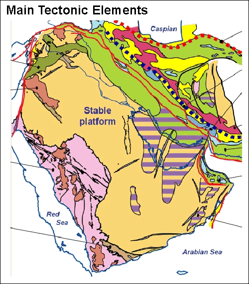
Figure 1. Main tectonic elements of the Arabian
|
|
|
Figure 2. Paleozoic continental drift of the Arabian |
|
|
Figure 3. Structure map, top crystalline basement. Click to view sequence of tectonic and structure maps (Figures 1 and 3). |


Paleozoic  Tectonics
The
Arabian ![]() plate
plate![]() contains a wide range of tectonic elements, from
Precambrian shield and Precambrian (Infracambrian) basin to Cenozoic
fold-thrust belt, locally with ophiolite (Figure 1). During the
Paleozoic, the
contains a wide range of tectonic elements, from
Precambrian shield and Precambrian (Infracambrian) basin to Cenozoic
fold-thrust belt, locally with ophiolite (Figure 1). During the
Paleozoic, the ![]() plate
plate![]() was affected by drift and rotation that resulted in
changes from equatorial to high southern latitudes and back to
equatorial (at the end of the Triassic), with two periods of glaciation
(Figure 2). Structure of the foredeep basin becomes increasingly complex
toward the foldbelt(s) (Figure 3).
was affected by drift and rotation that resulted in
changes from equatorial to high southern latitudes and back to
equatorial (at the end of the Triassic), with two periods of glaciation
(Figure 2). Structure of the foredeep basin becomes increasingly complex
toward the foldbelt(s) (Figure 3).
Paleozoic Stratigraphy


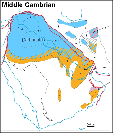
Regional unconformities, with two related to the Carboniferous Hercynian orogeny, divide Paleozoic strata into megasequences (Figures 5, 6, and 7. Deposition before the orogeny was dominated by clastics, whereas Permian deposits are characterized by the Khuff carbonates and evaporites. Much earlier, Late Precambrian rifting resulted in salt basins in Oman and the Arabian Gulf region (Figure 8). Extensive erosion resulting from the Hercynian orogeny is reflected by the subcrop patterns below the pre-Late Carboniferous unconformity (Figure 9).
Features of the Paleozoic stratigraphic section and interpretations of environments of deposition are illustrated in Figures 10, 11, 12, 13, 14, 15, 16, 17, 18, 19, 20, and 21. Some of the more striking features may be summarized as follows:
Widespread Middle Cambrian carbonates (Figure 10)
Widespread Middle Ordovician marine shales (Hanadir maximum flooding event) (Figure 13)
Upper Ordovician periglacial deposits (Figures 14 and 15)
Widespread Lower Silurian organic marine shale (Figure 16)
Upper Carboniferous (post-Hercynian) glacial deposits (Figure 19)
Lower
Permian carbonates in the southern part of the Arabian ![]() plate
plate![]() (Figure 20)
(Figure 20)
Widespread Upper Permian evaporites (Figure 21)
Hercynian Deformation
Figure Captions (22-30)


Regional cross-sections (Figures 22,
23, and 24),
in addition to tectonic, structural, and subcrop maps (Figures 1,
3, and
9), illustrate the general structural patterns and features of the
Arabian ![]() plate
plate![]() . Basement faults in the foredeep basin are well shown in
Figure 22, and inversion of Precambrian and Paleozoic subsident areas in
Oman and Syria are illustrated in Figures 23 and
24, respectively. The Hercynian orogeny resulted in intraplate broad
upwarps in Oman and Central Arabia, and
downwarp in northern Syria (Figure 25)
and associated widespread erosion. On the Central Arabia upwarp,
Silurian strata were completely eroded (Figure
26). Transpressional basement horsts in Eastern Arabia are
the underlying structure for the traps of the giant oil and gas fields
(e.g., Ghawar÷Figures 27,
28, 29, and
30).
. Basement faults in the foredeep basin are well shown in
Figure 22, and inversion of Precambrian and Paleozoic subsident areas in
Oman and Syria are illustrated in Figures 23 and
24, respectively. The Hercynian orogeny resulted in intraplate broad
upwarps in Oman and Central Arabia, and
downwarp in northern Syria (Figure 25)
and associated widespread erosion. On the Central Arabia upwarp,
Silurian strata were completely eroded (Figure
26). Transpressional basement horsts in Eastern Arabia are
the underlying structure for the traps of the giant oil and gas fields
(e.g., Ghawar÷Figures 27,
28, 29, and
30).
|
|
|
|
|
|
|
|
|
|
|
|
|
|
|
|
|


Two
hydrocarbon systems, based on source rock, have been identified:
Silurian and Precambrian (Figure 31). The source for the former is the Qusaiba hot shales, which were deposited over large areas of the Arabian
![]() plate
plate![]() (Figures 16). The hydrocarbons are trapped in Ordovician,
Silurian, Devonian, and Permo-Carboniferous sandstone reservoirs and
Permian carbonate reservoirs (Figures 32,
33, and 34). Except for
Central Arabia, the system is gas-prone, due deep burial of the source
rocks. The Precambrian source rocks have charged Precambrian, Paleozoic,
and Mesozoic reservoirs in the interior salt basins of Oman (Figures 35
and 36).
(Figures 16). The hydrocarbons are trapped in Ordovician,
Silurian, Devonian, and Permo-Carboniferous sandstone reservoirs and
Permian carbonate reservoirs (Figures 32,
33, and 34). Except for
Central Arabia, the system is gas-prone, due deep burial of the source
rocks. The Precambrian source rocks have charged Precambrian, Paleozoic,
and Mesozoic reservoirs in the interior salt basins of Oman (Figures 35
and 36).
Summary
-
Multi-company collaboration has significantly improved our understanding of the Paleozoic in the Arabian
plate .
. -
The Carboniferous Hercynian orogeny was the key to shaping the Paleozoic hydrocarbon habitat.
-
Two styles of Hercynian deformation
-
Regional sags and swells
-
Basement horsts
-
-
Two independent hydrocarbon systems
-
Silurian
-
Precambrian
-
á Silurian has high potential: USGS estimates it generated 808 TCF and 37 billion barrels of conventional resources.
-
Key challenges to Paleozoic exploration are seismic imaging and predicting reservoir quality.
Acknowledgments
Acknowledgment and appreciation is expressed to: AAPG, Saudi Aramco (Tom Connally, Dan Evans, John Filatoff, Said Al-Hajri, M. Dia Mahmoud, Jim McGillivray, Abdulla Al-Naim, Paul Nicholson), Shell (Geert Konert), Petroleum Development Oman (Henk Droste), ExxonMobil, and Gulf Petrolink (Moujahed Husseini).
About the Author
Dr. Abdulkader M. Afifi was educated in Saudi Arabia (B.S., University of Petroleum and Minerals, 1977) and in the United States (M.S. Colorado School of Mines. 1981; Ph.D., University of Michigan, 1990).
His experience includes:
1980-86 = U.S. Geological Survey Mission, Saudi Arabia; Geological Mapping, Geochemical and Stable Isotopic Studies of the Mahd Adh Dhahab Gold District.
1991-Present - Saudi Aramco, Dhahran, Saudi Arabia. Several technical and supervisory positions in the Exploration Organization including Chief Explorationist and Chief Geologist. Currently, Senior Geological Consultant, Upstream Ventures Department.