![]() Click to view article in PDF format.
Click to view article in PDF format.
Lower Skinner Valley Fill Sandstones: Attractive Exploration Targets on the Northeast Oklahoma Platform*
By
Jim Puckette1
Search and Discovery Article #10050 (2003)
*Adapted from presentation to Tulsa Geological Society, September 23, 2003.
1Oklahoma State University ([email protected])
Abstract
High-volume oil and gas accumulations occur in Desmoinesian (Pennsylvanian) Lower Skinner valley fills located on the Northeast Oklahoma Platform. Sandstones within these paleovalleys produce oil and gas from traps that combine two key components: porous reservoir and anticlinal folding. Skinner valleys formed in response to a drop in sea level. Lowstand stream erosion formed the resultant valleys, which form narrow, linear trends. Lower Skinner valleys that eroded through underlying “Skinner” highstand deltaic and marginal marine strata resulted in the juxtaposition of fluvial Lower Skinner Sandstone on the partially eroded Pink Limestone marker. In some cases, incision removed the Pink Limestone, and Skinner valley-fill sediments were deposited directly on Red Fork strata.
The heterogeneous nature of valley fills complicates oil and gas recovery. High-resolution stratigraphic correlation using wireline logs is useful in identifying potential isolated compartments. In the Northwest Sooner Valley Field in central Payne County, compartmentalization is confirmed by fluid and pressure data.
Porosity in valley-fill sandstones is mostly secondary and resulted from the dissolution of feldspar and metamorphic rock fragments. The combination of thicker sandstone, high porosity (16 to 20%) and permeability (>200 md), and favorable trapping conditions results in oil recoveries that often exceed 200 MBO per well. The shallow drilling depths on the Northeast Oklahoma Platform make these sandstones attractive exploration targets.
|
uNortheast Sooner Valley Field uNortheast Sooner Valley Field
uNortheast Sooner Valley Field uNortheast Sooner Valley Field
uNortheast Sooner Valley Field uNortheast Sooner Valley Field
uNortheast Sooner Valley Field uNortheast Sooner Valley Field
uNortheast Sooner Valley Field uNortheast Sooner Valley Field
uNortheast Sooner Valley Field uNortheast Sooner Valley Field
uNortheast Sooner Valley Field uNortheast Sooner Valley Field
uNortheast Sooner Valley Field uNortheast Sooner Valley Field
|
IntroductionDesmoinesian sandstones in Payne County, north-central Oklahoma, on the Northeast Oklahoma Platform are parts of well defined sequences that reflect changes in sea level, with limestone, dark shales, and/or coals as prominent markers beds separating sandstones with reservoir potential (Figures 1, 2, and 3). The Skinner Sandstone lies above the Pink Limestone and below the Verdigris Limestone. It is divisible into a lower and an upper interval by the Mineral Coal (Figures 2 and 3). The Lower Skinner interval in northeastern and north-central Oklahoma contains a number of major trends of channelized sandstone bodies (Figure 4), including the well developed surface equivalent, Chelsea Sandstone, in a local exposure northeast of Tulsa (Figure 5). The focus of this article is two fields in Payne County producing from channelized Lower Skinner Sandstone, interpreted to represent valley-fill deposits that formed as sea level began to rise after incision of the valleys during sea-level drop. These are the Northeast Sooner Valley Field and the Stillwater Field (Figure 1).
Click to view sequence of maps of Northwest Sooner Valley Field (Figures 6, 7, and 8).
Geometry of Lower Skinner Valley-Fill SandstoneNortheast Sooner Valley FieldStructure at the level of the Ordovician Viola Limestone contains very small-scale, very low-relief structures in an upthrown block of north-northeast-trending faults (Figure 6). One of these structures that was drilled as a Viola test was the site of the discovery of this Lower Skinner field. Structure on the Lower Skinner is a west- to northwest-plunging nose, with production where the paleovalley crosses the nose (Figure 7). Net sand in the Lower Skinner valley-fill sandstone locally is greater than 20 feet, and the northeast trend of sand thickness parallels that of the paleovalley, which ranges in width from more than ¼ mile to more than ¾ mile (Figure 8). The well developed sandstone shows a sharp base and locally lies directly on the Pink Limestone (Figures 9, 10, and 11). The valley fill contains more than one reservoir, as indicated by the vertical position of the sandstone bodies and the types and/or distribution of fluids and gas (Figures 10 and 11). In Figure 11, the updip producer has an oil-water contact higher than the base of other well that produces gas. Also, a well farther downdip produces from an older Lower Skinner Sandstone through which the paleovalley cut.
Stillwater FieldStructure on the Pink Limestone below the Lower Skinner Sandstone is characterized by a west-to northwest-plunging nose (Figure 12). The channelized Lower Skinner Sandstone trends north-south and is about ½ to ¾ mile wide (Figure 12), and the base of the valley-fill sandstone is generally sharp (Figures 13, 14, and 15). Thickness of the valley-fill deposits locally are as much as 70 feet (Figures 14 and 15), and they contain several sandstone bodies; illustrating multistoried and multilateral developments (Figures 13, 14, and 15), giving rise to compartments within the Lower Skinner Sandstone. Production is primarily from these deposits, but there is production from an older sandstone downdip from the paleovalley, which cut through this thinner sandstone.
Figure Captions (Figures 16-27)
Internal FeaturesNortheast Sooner Valley FieldThe Lower Skinner Sandstone, Pink Limestone, and upper part of the Red Fork Sandstone were cored in the Shively #1 (Figures 1, 16, and 17). As indication of a sea level change is an exposure surface recognized in the Upper Red Fork interval (Figure 18) below a “hot shale” marker at the base of the Pink Limestone (Figure 19). Somewhat surprisingly, the Pink contains within it a separate exposure surface (Figure 20). Depositional features in the Lower Skinner include inclined bedding, soft-sediment deformation, and clay clasts, some sub-parallel to inclined bedding, as well as fining-upward, multistoried units (Figures 21, 22, and 23). One interval of the Lower Skinner channel-fill sandstone shows a porosity of 17.6% and a permeability of 229 md (Figure 24). Permeability values range from 10 md to 200 md (Figure 16).
Stillwater FieldPart of the Lower Skinner Sandstone and the upper part of the Red Fork Sandstone were cored in the Overholt #1, north of Stillwater field in the Skinner paleovalley (Figure 25). The Skinner shows inclined bedding, interbedding, and some soft-deformation features (Figure 26). The sedimentary structures of the Red Fork are quite similar, with the last two features being somewhat more prominent (Figure 27).
Reservoir PerformanceIn Northeast Sooner Valley Field, one well has produced 374,000 barrels of oil. In Stillwater Field, two wells have produced 846,000 barrels of oil. In each case this suggests that the area of drainage is greater than the well spacing. It is thought that reservoir anisotropy and compartmentalization results in permeability parallel to paleovalley trend being substantially greater than that at right angles to the trend.
Summary
ReferencesAstarita, A.M., 1975, Depositional trends and environments of "Cherokee" sandstones, east-central Payne County, Oklahoma: Oklahoma State University unpublished M.S. thesis, 50 p. Chandler, C.E., 1977, Subsurface stratigraphic analysis of selected sandstones of the "Cherokee" Group, southern Noble County, Oklahoma: Shale Shaker, v. 28, no. 3. p. 56 [part 1]; v. 28, no. 4, p. 72-83 [part 2]. Cockrell, D.R., 1985, Stratigraphy, distribution and structural geology of Lower and Middle Pennsylvanian sandstones in adjacent portions of Okfuskee and Seminole Counties, Oklahoma: Oklahoma State University unpublished M.S. thesis, 55 p. Cole, J.G., 1968, Stratigraphic study of the Cherokee and Marmaton sequences, Pennsylvanian (Desmoinesian) east flank of the Nemaha Ridge, north-central Oklahoma: University of Oklahoma unpublished Ph.D. dissertation, 90 p. Lojeck, C.A., 1984, Petrology, diagenesis and depositional environment of the Skinner Sandstone, Desmoinesian, northeastern Oklahoma platform: Oklahoma State University unpublished M.S. thesis, 158 p. Pulling, D.M., 1979, Subsurface stratigraphic and structural analysis, Cherokee Group, Pottawatomie County, Oklahoma: Shale Shaker, v. 29, no. 6, p. 124-137 [part 1]; v. 29, no. 7, p. 148-158 [part 2]. Shipley, R.D., 1977, Local depositional trends of "Cherokee" sandstones, Payne County, Oklahoma: Shale Shaker, v. 28, no. 2, p. 24-35 [part 1]; v. 28, no. 3, p. 48-55 [part 2]. Siemers, W.A., 2003, Distribution and reservoir properties of Lower Skinner valley fill sandstones, Payne County, Oklahoma: Oklahoma State University unpublished M.S. thesis, 111 p. Shulman, C., 1966, Stratigraphic analysis of the "Cherokee" Group in adjacent portions of Lincoln, Logan and Oklahoma Counties, Oklahoma: Shale Shaker, v. 16, no. 6, p. 126-140. Valderrama, R., 1976, The Skinner sandstone zone of central Oklahoma: Shale Shaker, v. 26, no. 5, p. 86-98 [part 1]; v. 26, no. 6, p. 106-114 [part 2]. Verish, N.P., 1979, Reservoir trends, depositional environments and petroleum geology of "Cherokee" sandstones in T11-13N, R4-5E, central Oklahoma: Shale Shaker, v. 29, no. 9, p. 209 [part 1]; v. 29, no. 10, p. 224-237 [part 2].
AcknowledgmentsConocoPhillips for core analyses. KOPCO Inc. for providing core and subsurface data. Oklahoma Geological Survey Core Library for providing cores. Dr. Zuhair Al-Shaieb for advice and encouragement. School of Geology, Oklahoma State University, for facilities and support for research. |
 Figure 1. Index map for Payne
County on the Northeast Oklahoma
Figure 1. Index map for Payne
County on the Northeast Oklahoma Figure 2. Generalized
subsurface stratigraphy in north-central Oklahoma, showing prominent
marker beds and valley-fill sandstones in the Desmoinesian Red Fork,
Skinner, and Prue intervals.
Figure 2. Generalized
subsurface stratigraphy in north-central Oklahoma, showing prominent
marker beds and valley-fill sandstones in the Desmoinesian Red Fork,
Skinner, and Prue intervals. Figure 3. Wireline log
signatures and subsurface names for Skinner interval, Payne County,
Oklahoma.
Figure 3. Wireline log
signatures and subsurface names for Skinner interval, Payne County,
Oklahoma.
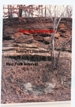 Figure 5. Chelsea Sandstone,
the surface equivalent of Skinner Sandstone, overlying the Tiawah
Limestone, Pink Limestone equivalent, above the Red Fork interval on
Oklahoma Highway 20 northeast of Tulsa.
Figure 5. Chelsea Sandstone,
the surface equivalent of Skinner Sandstone, overlying the Tiawah
Limestone, Pink Limestone equivalent, above the Red Fork interval on
Oklahoma Highway 20 northeast of Tulsa. Figure 6. Structure map on
top of Ordovician Viola Limestone, Northwest Sooner Valley field, T19N,
R3E, Payne County, Oklahoma.
Figure 6. Structure map on
top of Ordovician Viola Limestone, Northwest Sooner Valley field, T19N,
R3E, Payne County, Oklahoma. Figure 7. Structure map on
Lower Skinner Sandstone, Northwest Sooner Valley field, T19N, R3E, Payne
County, Oklahoma.
Figure 7. Structure map on
Lower Skinner Sandstone, Northwest Sooner Valley field, T19N, R3E, Payne
County, Oklahoma. Figure 8. Net thickness map
of Lower Skinner valley-fill sandstone, Northwest Sooner Valley Field,
T19N, R3E, Payne County, Oklahoma.
Figure 8. Net thickness map
of Lower Skinner valley-fill sandstone, Northwest Sooner Valley Field,
T19N, R3E, Payne County, Oklahoma. Figure 9. Stratigraphic
cross-section B-B' through Northwest Sooner Valley Field, showing Lower
Skinner valley-fill sandstone between relatively thin and older Lower
Skinner
Figure 9. Stratigraphic
cross-section B-B' through Northwest Sooner Valley Field, showing Lower
Skinner valley-fill sandstone between relatively thin and older Lower
Skinner  Figure 10. Stratigraphic
cross-section D-D' through Northwest Sooner Valley Field, showing Lower
Skinner valley-fill sandstone.
Figure 10. Stratigraphic
cross-section D-D' through Northwest Sooner Valley Field, showing Lower
Skinner valley-fill sandstone. Figure 11. Cross-section
D-D', using a common elevation as the datum, with pertinent production
data. Two Lower Skinner reservoirs are within the valley-fill deposits,
and one is downdip from the paleovalley.
Figure 11. Cross-section
D-D', using a common elevation as the datum, with pertinent production
data. Two Lower Skinner reservoirs are within the valley-fill deposits,
and one is downdip from the paleovalley. Figure 12. Structure map on
Pink Limestone (below Skinner Sandstone), Stillwater Field, T19N, R2E,
Payne County, Oklahoma, with trends of channelized Lower Skinner
sandstone.
Figure 12. Structure map on
Pink Limestone (below Skinner Sandstone), Stillwater Field, T19N, R2E,
Payne County, Oklahoma, with trends of channelized Lower Skinner
sandstone. Figure 13. Stratigraphic
cross-section A-A' through Stillwater Field, with unusually thick
development of Lower Skinner Sandstone as a valley-fill deposit
Figure 13. Stratigraphic
cross-section A-A' through Stillwater Field, with unusually thick
development of Lower Skinner Sandstone as a valley-fill deposit  Figure
17. Photograph of cored interval, Shively #1.Wireline log of interval in
Figure
17. Photograph of cored interval, Shively #1.Wireline log of interval in Figure
18. Exposure surface in Upper Red Fork interval, showing oxidized fill
in fractures and macropores, along with rootlets.
Figure
18. Exposure surface in Upper Red Fork interval, showing oxidized fill
in fractures and macropores, along with rootlets.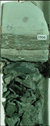 Figure
19. Photograph of base of Pink Limestone and underlying dark shale.
Basal Pink zone is a "hot shale" marker.
Figure
19. Photograph of base of Pink Limestone and underlying dark shale.
Basal Pink zone is a "hot shale" marker.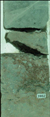 Figure
20. Exposure surface within the Pink Limestone, a regolith zone that
shows the effects of oxidation.
Figure
20. Exposure surface within the Pink Limestone, a regolith zone that
shows the effects of oxidation. Figure
21. Depositional features within Lower Skinner Sandstone, inclined
bedding, soft-sediment deformation, and clay clasts.
Figure
21. Depositional features within Lower Skinner Sandstone, inclined
bedding, soft-sediment deformation, and clay clasts. Figure
22. Lower Skinner Sandstone, showing the contact between two
fining-upward depositional units, represented respectively by very
fine-grained sand unit below fine- to medium-grained sandstone.
Figure
22. Lower Skinner Sandstone, showing the contact between two
fining-upward depositional units, represented respectively by very
fine-grained sand unit below fine- to medium-grained sandstone.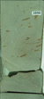 Figure 23. Lower Skinner
channel-fill sandstone, at 3890, showing clay clasts sub-parallel to
inclined bedding.
Figure 23. Lower Skinner
channel-fill sandstone, at 3890, showing clay clasts sub-parallel to
inclined bedding. Figure 24. Lower Skinner
channel-fill sandstone, at 3887 feet, with 17.6% porosity and 229 md
permeability.
Figure 24. Lower Skinner
channel-fill sandstone, at 3887 feet, with 17.6% porosity and 229 md
permeability. Figure 25. Wireline logs and
cored intervals, which includes Lower Skinner valley-fill sandstone, in
Overholt #1, Section 1, T19N, R2E, Payne County, Oklahoma, north of
Stillwater Field.
Figure 25. Wireline logs and
cored intervals, which includes Lower Skinner valley-fill sandstone, in
Overholt #1, Section 1, T19N, R2E, Payne County, Oklahoma, north of
Stillwater Field. Figure 26. Photograph of core
of Lower Skinner Sandstone, Overholt #1, Section 1, T19N, R2E, Payne
County, Oklahoma. The lowermost 12 feet of Lower Skinner is not present
in core.
Figure 26. Photograph of core
of Lower Skinner Sandstone, Overholt #1, Section 1, T19N, R2E, Payne
County, Oklahoma. The lowermost 12 feet of Lower Skinner is not present
in core. Figure 27. Photograph of core
of Red Fork Sandstone from Overholt #1, Section 1, T19N, R2E, Payne
County, Oklahoma.
Figure 27. Photograph of core
of Red Fork Sandstone from Overholt #1, Section 1, T19N, R2E, Payne
County, Oklahoma.