![]() Click to view page images in PDF format.
Click to view page images in PDF format.
TECTONO-STRATIGRAPHIC FRAMEWORK OF THE NORTH FALKLAND BASIN: POST-DRILLING ANALYSIS
P. C. Richards*and B. V. Hillier**
Search and Discovery Article #10016 (2001)
Adaptation of article, entitled Post-Drilling Analysis of the North Falkland Basin—Part 1: Tectono-Stratigraphic Framework, by the same authors, published in Journal of Petroleum Geology, vol. 23 (3), July 2000, p. 253-272. Appreciation is expressed to the authors and to Christopher G. H. Tiratsoo, Scientific Press Ltd. and Journal of Petroleum Geology (www.jpg.co.uk).
*British Geological Survey, West Mains Road, Edinburgh, EH9 3LA.
**Shell Production and Development Ltd (Falklands Branch), Shell Centre, London.
Correspondence to [email protected].
Six wells were drilled in the extensional North Falkland Basin in 1998. The wells encountered a Devonian to Cenozoic stratigraphy dominated by thick Mesozoic syn-and post-rift successions. Although most previously published models predicted that the succession would most likely be of marine origin, it is in fact predominantly terrestrial; marine conditions did not become established in the basin until the Late Cretaceous. The oldest rocks recorded are Devonian and these were penetrated in only one well. The overlying succession comprises: a fluvio-lacustrine, early syn-rift interval of ?mid-Jurassic to Tithonian age; a late syn-rift fluvio-lacustrine interval of Tithonian to Berriasian age; a rift-sag transitional unit of Berriasian to Valanginian age; an early post-rift lacustrine unit of Valanginian to early Aptian age; a middle post-rift, transgressive unit of Aptian to Albian age; a late post-rift, terrestrial to marine unit of Albian to early Palaeocene age; and a post-uplift thermal subsidence unit of Palaeocene to Recent age.
Much of the sediment appears to have been derived from volcanic and/or metamorphic terranes, probably located to the north or NW of the basin. As well as the volcanic material which occurs in the ground mass and as lithoclasts in many of the units, some volcaniclastic rocks and minor amounts of ashfall tuffs are observed, particularly within the late syn-rift succession.
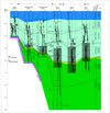 Fig. 2. Log correlation of the eight
tectono-stratigraphic sequences and the
associated sub-units in the six wells in the North Falkland Basin.Gamma-ray log
scale on each well is from 0 to 150 API, sonic log scale is from 140 to 40
microsecs/ft. The Late Jurassic to Early Cretaceous lacustrine claystone that
forms the primary source rock interval in the basin is shaded grey. See Fig.1
for location of wells.
Fig. 2. Log correlation of the eight
tectono-stratigraphic sequences and the
associated sub-units in the six wells in the North Falkland Basin.Gamma-ray log
scale on each well is from 0 to 150 API, sonic log scale is from 140 to 40
microsecs/ft. The Late Jurassic to Early Cretaceous lacustrine claystone that
forms the primary source rock interval in the basin is shaded grey. See Fig.1
for location of wells.
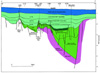 Fig. 3. Composite SW-NE cross section based on interpretations of seven
intersecting seismic lines (four oriented E-W and three oriented N-S) traversing
the North Falkland Basin. The section illustrates the relationships between the
tectono-stratigraphic units in three of the wells. Vertical scale in
milliseconds of two-way travel time (TWT). See Fig.1 for location.
Fig. 3. Composite SW-NE cross section based on interpretations of seven
intersecting seismic lines (four oriented E-W and three oriented N-S) traversing
the North Falkland Basin. The section illustrates the relationships between the
tectono-stratigraphic units in three of the wells. Vertical scale in
milliseconds of two-way travel time (TWT). See Fig.1 for location.
Click here for view of cross-section (Fig. 3) with seismic section (Fig. 4).
 Fig. 4. Part of an E-W seismic line across the Eastern
Depocentre,
illustrating the relationship between the early syn-rift, late syn-rift,
transitional unit, early post-rift and middle post-rift units. Data reproduced
courtesy of Spectrum Energy and Information Technology Ltd. PR=pre-rift;
ES-R=early
syn-rift; LS-R=late
syn-rift; TU=transitional
unit; EP-R=early
post-rift; MP-R=middle
post-rift; LP-R=late
post-rift; P-US=post-uplift
sag. See Fig. 1 for location.
Fig. 4. Part of an E-W seismic line across the Eastern
Depocentre,
illustrating the relationship between the early syn-rift, late syn-rift,
transitional unit, early post-rift and middle post-rift units. Data reproduced
courtesy of Spectrum Energy and Information Technology Ltd. PR=pre-rift;
ES-R=early
syn-rift; LS-R=late
syn-rift; TU=transitional
unit; EP-R=early
post-rift; MP-R=middle
post-rift; LP-R=late
post-rift; P-US=post-uplift
sag. See Fig. 1 for location.
Click here for view of cross-section (Fig. 3) with seismic section (Fig. 4).
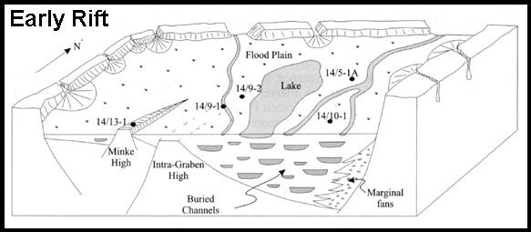
Click here for sequence (animation) of Early Rift (Fig. 5) and Early Post-Rift (Fig. 7).
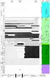 Fig. 6.
Sequence-stratigraphic
representation of well correlation in the North Falkland Basin.
Fig. 6.
Sequence-stratigraphic
representation of well correlation in the North Falkland Basin.
Click here for sequence (animation) of Early Rift (Fig. 5) and Early Post-Rift (Fig. 7).
Table 1. The six wells drilled in the North Falkland Basin in 1998.
STRATIGRAPHY OF THE NORTH FALKLAND BASIN
The pre-rift interval (Devonian)
Lithology, Palynology, Depositional Environment, Age
The early syn-rift unit (? Mid-Jurassic to ?Tithonian)
Lithology, Palynology, Depositional Environment, Age
The late syn-rift unit (Tithonian to Berriasian)
Lithology, Palynology, Depositional Environment, Age
The rift to sag transition (?Berriasian to ? Valanginian)
Lithology, Palynology, Depositional Environment, Age
The early post-rift unit (Valanginian to ?Aptian)
Lithology, Palynology, Depositional Environment, Age
The middle post-rift unit (Aptian to Albian)
Lithology, Palynology, Depositional Environment, Age
The late post-rift succession (Albian to early Palaeocene)
Lithology, Palynology, Depositional Environment, Age
Post-uplift sag subsidence (Palaeocene-Recent)
Lithology, Palynology, Depositional Environment, Age
This paper summarises the stratigraphy of the six exploration wells which were drilled in the North Falkland Basin in the period April to November 1998 (Fig. 1 and Table 1). On the basis of these wells and an extensive database of seismic reflection profiles, a new tectono-stratigraphic framework is erected to describe the evolution of the basin and to provide a predictive model to aid further exploration. Changes in our understanding of the petroleum geology and remaining exploration potential of the basin resulting from this drilling campaign are discussed in a companion paper by Richards and Hillier (2000).
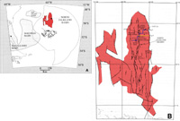
The regional geology and palaeogeographic evolution of the offshore Falkland Islands has been well documented (Richards and Fannin, 1994; Richards, 1995 and 1997; Lawrence and Johnson, 1995; Platt and Philip, 1995; Richards et al., 1996 a and b; Richards and Fannin 1997). Four Mesozoic-Cenozoic sedimentary basins surround the Falkland Islands: the Falkland Plateau Basin, Malvinas Basin and South Falkland Basin lie to the east, west and south of the islands respectively, while the North Falkland Basin lies directly to the north (Fig. 1a).
Richards et al. (1996 a and b), Richards and Fannin (1997), Thomson and Underhill (1999), Bransden et al. (1999)and Lawrence et al. (1999)gave differing overviews of the structural and stratigraphic setting of the North Falkland Basin, and the associated main rift zone which was termed the North Falkland Graben by Richards and Fannin (1997)(Fig. 1b). Although these papers were compiled before drilling started, many (but by no means all) of the conclusions and interpretations presented in them are still valid following the 1998 drilling campaign. The biggest changes in understanding resulting from drilling concern the basin’s stratigraphy, sedimentary geology and petroleum system mechanics.
Richards et al. (1996a and b) and Richards and Fannin (1997)suggested that the infill of the North Falkland Basin may be analogous to the successions observed in the San Jorge Basin to the west, in Argentina (Fitzgerald et al., 1990). The analogy proved to be a reasonable one since both basins appear to have been dominated by fluvio-lacustrine deposition until quite late in their development. The stratigraphy of other nearby Argentine basins, particularly the offshore Malvinas Basin and the San Julian Basin (Fig. 1a), proved, after drilling, to have very little similarity to that observed in the North Falkland Basin. Figueredo et al. (1996) noted that before drilling in the San Julian Basin took place, it was anticipated that this basin would have an infill comparable to that of the San Jorge Basin. However, drilling proved that the succession was different in many respects, with a rift-to-sag transition occurring there much later than in the San Jorge Basin. The San Julian Basin exhibits a more comparable stratigraphy to that of the Deseado Masssif which separates the Malvinas and Magellanes Basins (Figuerido et al., 1996), and is unlike the drilled succession in the North Falkland Basin.
The North Falkland Basin lies beneath 150 m to 2, 000 m of water. It consists of a complex system of offset depocentres following two dominant structural trends (NW-SE and north- south), and displays a structural style quite different to the other offshore Falkland Islands basins. Its margins are mostly faulted (Fig. 1b), and it is surrounded by a structural platform composed of sedimentary rocks of probable Devonian age. The geometry and tectonic evolution of the basin was documented by Richards and Fannin (1997), who noted that two major depocentres, the Western Depocentre and the Eastern Depocentre, are separated by a faulted ridge termed the Intra-Graben High. Another fault-bounded high within the Western Depocentre is referred to here as the Minke High. The Intra-Graben High appears to have been a positive feature influencing sedimentation during much of the basin’s evolution. The Minke High appears to have been emergent, and the site of non-deposition, throughout the deposition of the syn-rift succession and through into the early part of the post-rift phase.
Richards et al. (1996 a and b), Richards and Fannin (1997), Thomson and Underhill (1999) and Bransden et al. (1999)noted that the infill of the North Falkland Graben could be subdivided into tectono-stratigraphic units on the basis of seismic geometries. These authors recognised various rift and post-rift phases, and assigned tentative ages to their units on the basis of correlations with offshore Argentine and South African basins. Elements of each of the predicted basin-infill models appear to be confirmed by drilling.
Six wells were drilled in the North Falkland Graben in 1998 (Fig. 1b); three were drilled in the Eastern Depocentre (14/5-1A, 14/10-1 and 14/24-1 ), two on the Intra-Graben High (14/9- 1 and 14/9-2 ), and one on the Minke High in the Western Depocentre (14/13-1 ). The wells allow significant refinements to be made to the original models of the tectono-stratigraphic history of the basin.
The collection of a full suite of downhole logs was attempted in each well, although technical problems with hole-integrity resulted in the abandonment of some logging runs, particularly in the deeper part of Well 14/13-1. A full set of wet and dried cuttings, rotary-and percussion side-wall core samples were collected from each well, and three conventional cores were cut: two from Well 14/9-1 and one from Well 14/24-1. Biostratigraphical analyses were carried out at the well site during drilling and/or at various specialist contractors’ laboratories; post-drilling biostratigraphical analyses were made at two different laboratories. The results were variable, with no consistent age determinations being made by analysing palaeontological and palynological data from different wells. Thin-section and XRD petrological studies were conducted by all the drilling companies at a number of contractors’ laboratories, while sedimentological studies were undertaken by contractors and also by the authors. Detailed matching of mineralogy and lithology to wireline log response was undertaken by the drilling companies for calibration purposes. Heavy-mineral analysis of the entire succession at Well 14/9-1 was undertaken by the British Geological Survey in order to determine the provenance area for the sediments and to determine the likely contribution from the Falkland Islands themselves.
The stratigraphic correlation and subdivisions used in this paper are defined using a framework based on seismic stratigraphy and seismic geometry, established as a result of interpreting and mapping all of the seismic data (including proprietary data) in the basin (over 20, 000 km of 2D data plus over 300 km2 of 3D data). The major bounding surfaces of the tectono-stratigraphic units defined below are based on the identification of regionally-mappable unconformities and correlative unconformities. The mapped seismic horizons were tied to well logs and lithology, as well as to the biostratigraphy framework (where sufficient data were available), in order to define meaningful correlation units.
STRATIGRAPHY OF THE NORTH FALKLAND BASIN
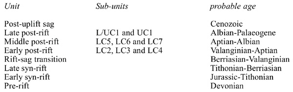
Eight regionally-correlatable tectono-stratigraphic units are now recognised in the basin (Figs. 2 and 3). Each of the seismically-identified sequence boundaries defining the units has been tied to downhole logs in the six wells. The eight tectono-stratigraphic units are: a pre-rift succession; an early syn-rift interval; a late syn-rift interval; a transitional unit; an early post- rift interval; a middle post-rift interval; a late post-rift interval; and a post-uplift sag unit. These major units are described in turn below.
In addition to these major units, eight sub-units of basin-wide significance have been identified in the early, middle and late post-rift succession (Fig. 2), and these do not coincide with changes in the tectonic regime. These sub-units are termed LC2-7, L/UC1 and UC1 (where LC is Lower Cretaceous and UC is Upper Cretaceous). The sub-units are interpreted to form distinct sequences and/or parasequence sets, and are bounded by seismic reflectors that separate intervals with differing depositional environments, reflecting the basinward or landward shift of facies belts. Sub-unit boundaries also represent changes in stacking patterns, and in the nature of the seismic offlaps, downlaps or terminations observed at their boundaries. Detailed description of the sub-units is beyond the scope of this paper.
The pre-rift interval (Devonian)
The pre-rift interval was encountered only in Well 14/9-1 on the crest of the Intra-Graben High (Figs. 2 and 3), which penetrated 49 m of the unit. Samples from this location are not necessarily typical of the Devonian succession elsewhere in the basin, nor of pre-rift rocks in the region. For example, Galeazzi (1998)noted that the pre-rift succession in the Malvinas Basin to the SW consists of low-grade meta-sedimentary rocks and granites.
The unit lies beneath a prominent, high-amplitude reflector some 0. 38s TWT below the crest of the Intra-Graben High, and appears to form the buried core of the high. The reflector can be mapped into deeper parts of the basin, where it is interpreted to represent the base of the Mesozoic sedimentary succession. The top of the unit is picked at a downwards increase in bulk density and a decrease in interval transit time (Fig. 2), as well as at a downwards change in dip direction from 180 ° to about 50 °. It is defined by the downwards transition from Jurassic or indeterminate Mesozoic rocks to Devonian sedimentary or metasedimentary rocks.
Lithology
The only thin section available shows a moderately well-sorted silty mudstone with subrounded to subangular grains, a weak to moderate compaction fabric and some evidence of low-angle laminations defined by silt-sized grains. The detrital mineralogy is dominated by illite clays, with abundant carbonaceous material and minor amounts of monocrystalline quartz, muscovite, biotite and chlorite.
Palynology
Some unidentifiable and poorly preserved spores of terrestrial origin were recorded, together with a single Palaeozoic marine algal specimen. All the palynological material is in a post- mature state of thermal alteration.
Depositional environment
The palynoflora is dominated by miospores of terrestrial origin suggesting a lacustrine or fluvio-lacustrine depositional environment, although the occurrence of a single marine alga may indicate at least intermittent marine conditions.
Age
Although only sparse, poorly preserved microfossils have been recovered from this unit, the occurrence of Emphanisporites spp and Perotrilites microbaculatius suggest a Devonian age.
The early syn-rift unit (?Mid-Jurassic to ?Tithonian)
This unit was encountered in both Wells 14/9-1 and 14/9-2, drilled respectively on the crest of the Intra-Graben High and in a near-crestal location on its eastern flank, and also in Well 14/5-1A near the centre of the Eastern Depocentre. It is absent at the 14/13-1 locality (Fig. 2), having pinched out westwards onto the Minke High within the Western Depocentre (Fig. 3). The unit lies below TD in Wells 14/10-1 and 14/24-1.
This unit is the lowermost wedging seismic package above Palaeozoic basement. Its top is defined by a high-amplitude seismic marker in the Eastern Depocentre which separates the early and late syn-rift seismic units (Fig. 4). The reflector is not easily identifiable over the crest of the Intra-Graben High, but is recognisable on its eastern flank as an onlap surface.
In both Wells 14/9-1 and 14/5-1A, the top of the unit is picked at the base of a relatively low gamma interval which coincides with the top of an interval with a gradual downwards decrease in interval transit time (Fig. 2). The top of the unit corresponds to a downwards decrease in miospore abundance and degree of preservation in the Well 14/9-1. Sidewall core samples from both 14/9-1 and 14/5-1A indicate that kaolinite is virtually absent in this sequence, while illite forms a more pervasive clay phase than in younger units.
Lithology
The sequence varies laterally between Wells 14/9-1, 14/9-2 and 14/5-1A. In Wells 14/9-1 and 14/9 – 2 drilled on the Intra-Graben High, the unit is dominated by conglomerates, conglomeratic sandstones, sandstones and tuffs with minor quartzites and interbedded claystone. In Well 14/5-1A near the middle of the Eastern Depocentre, the unit comprises mostly silty claystone, with sandstones up to 5-m thick. The claystones are silty to very silty, medium brown to white in colour, soft, sticky and plastic. In the lowest part of the sequence at Well 14/ 5-1A, the claystones contain more tuffaceous material. The sandstones are feldspathic, fine-to medium-grained, sub-angular to sub-rounded, moderately well sorted, with white calcareous coatings to grains giving a frosted appearance.
Palynology
Palynomorph recovery is significantly poorer in this unit than in the overlying units. Sparse, poorly preserved miospores are characteristic of the unit in the finer-grained sediments of the 14/5-1A well. The miospore Cyclusphaera psilata is occasionally recorded here, and may be caved. Other palynomorphs recovered include frequent inaperturate pollens, rarer, bisaccate pollen, and some pteridophyte spores.
Depositional Environment
The unit was probably deposited in a fluvial or fluvio-lacustrine setting, possibly with alluvial fans shedding sediment into the basin from the margins (Fig. 5). The Intra-Graben High was probably a slight topographic ridge at the time, and was present to the west of the tilt-fulcrum during the early syn-rift phase in the Eastern Depocentre, which was structurally deepest adjacent to the eastern basin-bounding fault. This region may have been the locus of fluvial sedimentation, prior to the avulsion of fluvial channels towards the developing low area adjacent to the eastern basin-bounding fault. Alternatively, the developing Intra-Graben High may have formed the shoreline area of a fluvial/lacustrine depositional environment, and thus received coarser sediment than the central parts of the Eastern Depocentre. The finer- grained, claystone-dominated succession found in the more centrally located 14/5-1A well possibly represents lacustrine and intermittent fluvial deposition closer to the deepest part of the evolving rift.
Age
Although all taxa recovered are generally long-ranging, they suggest an age no older than Middle Jurassic. A number of biostratigraphers have examined sample preparations from different wells; consequently, the sequence has been interpreted in some wells as ranging from Middle to Late Jurassic, but in others as ranging up to possibly Valanginian. Given the probable age of the overlying sequence, it is most likely that the sequence ranges in age from ?Middle Jurassic to Tithonian (Fig. 6), although its top may be slightly younger. A seismic sequence with a similar geometry and position near the base of the rift section was identified by Figuerido et al. (1996)in the San Julian Basin but was interpreted as being of Permian age.
The late syn-rift unit (Tithonian to Berriasian)
This unit was encountered in all wells except 14/13-1, from where it is absent due to pinchout towards the Minke High in the Western Depocentre (Figs. 2 and 3). The unit forms the late syn-rift phase of basin infill, and comprises a wedge-shaped seismic package displaying some onlap of reflectors onto the tilted top surface of the early syn-rift sequence (Fig. 4). Fig. 2 shows that the top of the unit is generally marked by a downwards decrease in interval transit time and a downwards increase in gamma-ray values; there is also a downwards decrease in Compensated Neutron Log porosity values.
Lithology
Lithofacies types vary according to the palaeogeographic position of the wells. In Well 14/ 9-1 located on the crest of the Intra-Graben High, the sequence comprises a lower conglomerate interval and an upper claystone interval. The conglomerate is pale green to brownish grey, with a clay matrix in places. Side-wall core samples from near the base of the conglomerate consist almost entirely of cryptocrystalline silica glass and microcrystalline quartz. The overlying claystone interval is light to medium grey, pale brown and brownish grey.
Well 14/5-1A, located nearer the middle of the Eastern Depocentre, encountered a claystone- dominated succession with thin sandstone beds, which had a total thickness of about 120 m. The sequence in Well 14/24-1 in the southern part of the basin is dominated by tuffaceous claystones, which are pale to dark grey-green, moderately hard, with some relict granular texture and occasionally visible crystals. Most of these tuffs represent reworked volcanic material deposited by sedimentary processes. Minor amounts of matrix-and clast-supported conglomerates and current-rippled sandstones are also present, as is the local development of rootlet structures. Similar reworked tuffaceous sedimentary rocks have been described by Figuerido et al. (1996)from the rift succession in the nearby San Julian Basin, although Galeazzi (1998)described a sequence dominated more by volcaniclastic and rhyolitic rocks (the so- called Tobifera volcanics)from the Malvinas Basin.
Palynology
In Well 14/9-1, the unit has a rich to moderately rich, non-marine palynomorph assemblage. In Well 14/5-1A, the palynofloral assemblage contains the fresh-to brackish-water alga Celyphus rallus, and Botryococcus. Kerogen is dominated by abundant, pyritised amorphous organic matter, with subordinate structured inertinite and vitrinite phytoclasts. In Well 14/24-1, the unit is dominated by miospores particularly gymnosperm pollen, while non-marine to brackish- water algae are also common.
Depositional Environment
In common with the underlying sequence, the late syn-rift interval was probably deposited in a fluvio-lacustrine environment. The coarser-grained sedimentary rocks found at the base of the sequence at the crest of the Intra-Graben High probably represent, as in the underlying unit, lacustrine shoreline deposits fringing a more permanent lake, before the establishment of more pervasive lacustrine conditions at this location (as interpreted from the overlying units). The succession in Well 14/5-1A near the middle of the Eastern Depocentre has a mixed sandstone/claystone basal unit of possible lacustrine ?turbidite origin, but becomes less sand- rich upwards, possibly reflecting the establishment of permanent lacustrine conditions towards the end of the late syn-rift period. In Well 14/24-1 in the southern part of the Eastern Depocentre, the claystones are largely tuffaceous. These were probably deposited in a low energy lake, with some infrequent high-energy depositional events indicated by the presence of matrix- and clast-supported conglomerates and current-rippled sandstones. The localised presence of ?early diagenetic mottling and rootlets may indicate the development of incipient soil profiles at the lake margin or in a waterlogged, marshy setting. Less tuffaceous claystones overlie the tuff-dominated succession in Well 14/24-1, and may represent the re-establishment of permanent lacustrine deposition together with a decrease in the availability of volcanic material, as a result of drowning of a local source area as lacustrine conditions expanded. Lambiase (1990) demonstrated that syn-rift successions in continental basins tend to be dominated by semi- permanent lakes in their central portions.
Age
This sequence has been variously assigned (by different biostratigraphers working on different wells)as Tithonian to Valanginian, Valanginian to Barremian, or Tithonian to Berriasian. Most of the taxa recovered are long-ranging, but they are comparable to other Late Jurassic to Berriasian assemblages known from the Springhill Formation of Argentina and Chile. This unit is probably of Tithonian to Berriasian age (Fig. 6), although it is possible that its top lies within the Valanginian.
The rift to sag transition (?Berriasian to ?Valanginian)
This unit can be identified in all wells except 14/13-1 ; it pinches out onto the flanks of the Minke High within the Western Depocentre (Figs. 2 and 3). It has a lensoid profile (Fig. 3), indicating that it may represent the first phase of sag-infill of the basin. The top of the unit is defined as the base of a series of high amplitude reflections (Fig. 4), and in most wells by a downwards decrease in interval transit time, a downwards decrease in gamma values (Fig. 2), a downwards decrease in Compensated Neutron Log porosity values and a slight downwards decrease in bulk densities.
Lithology
This unit is generally claystone dominated. Thus, in Well 14/5-1A near the centre of the Eastern Depocentre, the unit comprises an organic-rich claystone which is medium to dark greyish brown, firm to moderately hard, blocky to sub-fissile, micromicaceous, silty in part, generally clean and homogenous, and increasingly indurated with depth. Traces of well sorted, kaolinitic sandstones are recorded at some levels. Well 14/9-1 shows the only variation to the dominant claystone lithology; here, as well as tuffaceous claystones, the unit comprises weathered conglomerates which are poorly sorted and contain angular to subrounded lithic clasts.
Palynology
The unit is not distinguishable as a distinct palynological unit in any of the wells. It appears to contain assemblages similar to those in the overlying early post-rift succession, being dominated by fresh-to brackish-water alga and non-marine miospores.
Depositional Environment
As in the underlying units, the succession at the crestal Well 14/9-1 possibly represents a shoreline depositional environment fringing a lake. The claystone-dominated successions in the other Eastern Depocentre wells (including Well 14/9-2 on the flank of the ridge)may represent sites of more permanent lacustrine deposition.
Age
This unit is relatively thin and it is difficult to differentiate it in terms of biostratigraphy from the overlying claystone succession of the early post-rift sequence. The most likely age range for this unit is probably Berriasian to Valanginian (Fig. 6).
The early post-rift unit (Valanginian to ?Aptian)
The early post-rift unit is probably present in all six wells, although the lowermost part is present only in the Eastern Depocentre and on the eastern flanks of the Intra-Graben High (Figs. 2 and 3). The early post-rift succession is represented by a saucer-shaped seismic package developed above the syn-rift wedges and the transitional unit. The top of the unit is picked at a seismic reflector which defines the top of a lowstand seismic package occurring in front of a Lower Cretaceous delta (Fig. 2)originally identified by Richards and Fannin (1997), which prograded into the basin from the north. The top of the unit is marked by a downwards increase in gamma-ray log response and a significant downwards increase in interval transit time and bulk density (Fig. 2).
The early post-rift unit is divisible into three seismic or sequence stratigraphic sub-units (Fig. 2). Sub-unit LC2 at the base of the succession is characterised by an interval of high- amplitude, sub-parallel reflectors, and is observed on seismic sections to pass northwards into the oldest deltaic foreset deposits recognised in the Eastern Depocentre. The overlying sub- unit LC3 is more seismically transparent over much of the basin, and in the northern part of the Eastern Depocentre contains the main, progradational part of the Lower Cretaceous delta. The topmost sub-unit, LC4, is present only locally within the Eastern Depocentre, directly to the south of the delta foresets, and is interpreted to represent a period of lowstand deposition following maximum delta progradation into the basin.
Lithology
The early post-rift succession is dominated by massive claystones with minor sandstones, siltstones and interbedded dolomite. A sandier succession comprising much of sub-units LC2 and LC3 is present in the northern parts of the basin, representing deltaic progradation mainly from the north, although minor deltaic lobes also prograded from both the western and eastern margins of the basin.
The claystones which dominate the succession are grey to brown coloured, soft to firm, amorphous or blocky to sub-fissile, slightly calcareous, rarely pyritic, carbonaceous, and occasionally micromicaceous, with rare plant remains. Interbedded with them are buff-coloured, soft to firm, amorphous to sub-blocky, silty and carbonaceous dolomite beds, up to 2-m thick (which cause the high seismic reflectivity of the unit), and also rarer, silty sandstones.
Well 14/5-1A, the northernmost well in the Eastern Depocentre, penetrated the deltaic system draining from the north. Near the top of this deltaic interval, presumed topset deposits comprise interbedded argillaceous sandstones and claystones. The argillaceous sandstones are very fine grained and moderately well sorted, with detrital components comprising abundant mono-and polycrystalline quartz grains, K-feldspar and volcanic and metamorphic rock fragments. The topset claystones are dark brown, with abundant flakey (woody?)particles, locally abundant silt grains, and scattered, small, golden-brown phosphate grains. Beneath these seismically-imaged topset deposits, the dipping foreset interval comprises claystones interbedded with sandstone, silty or sandy claystones and rare dolomite. The sandstones are translucent to orange green and include mixed lithic fragments including volcanics, cherts and quartzites. They are fine-to very coarse-grained, poorly-sorted and angular to sub-rounded. The sand grains have occasional white kaolinitic coatings and are rarely cemented. Lithic clasts within the sandstones include trachytic and rhyolitic volcanics, and the dominant quartz grains generally have a thin veneer of microcrystalline quartz. The seismically imaged, flat- lying bottomset interval comprises claystones and silty claystones with thin sands and dolomite stringers that produce high-amplitude seismic reflections.
Palynology
The succession is dominated by the fresh-to brackish-water alga Botryococcus, Celyphus rallus and rarer Pediastrum.
Depositional Environment
The dominant claystone lithologies of this succession were deposited in a lacustrine setting, as indicated by the general absence of marine indicators in the palynological assemblages. A similar lacustrine setting was reported for the D129 succession in the nearby San Jorge Basin (Fitzgerald et al., 1990), although Galeazzi (1998)reported that generally similar claystones in an early post-rift setting in the Malvinas Basin to the SW are of marine origin.
The presence of interbedded dolomites within the claystones may suggest possible drying phases with evaporitic conditions in relatively shallow-water areas. Alternatively, carbonate- rich layers may represent deposition in a relatively deep lake during dry climatic periods, and organic-rich rocks may represent deposition during wetter periods (cf. Collinson, 1978). The occurrence of thin coals at Well 14/24-1 point to shallow-water, lake margin conditions at this location, although water depths may have been considerably greater elsewhere. Dipping seismic reflectors interpreted as progradational foresets in the northern part of the Eastern Depocentre (see below) have a height of around 500m, suggesting that lake depths were of this order of magnitude.
The occurrence of fish remains and ostracods in places indicates that the lake was oxygenated, at least in the upper parts of the water column. However, total organic carbon values averaging 5%, and oil yield values (determined by Rock-Eval pyrolysis: Richards and Hillier, 2000) up to 74. 5 kg HC/tonne of rock in well 14/10-1 suggest the development of anoxic bottom conditions. In present-day East African lakes, the highest TOC values are recorded in lakes that are either permanently stratified or are only episodically overturned (Talbot, 1988). However, TOC values of 1. 4% to 4% have been recorded in lakes that are occasionally stratified (Talbot, 1988). Katz (1990) showed that the highest organic concentrations, and the highest hydrocarbon generating potentials, are found in East African lakes of intermediate water depths (50 to 400m), possibly because of the increased phytoplankton production in these lakes compared to deeper, permanently-stratified water bodies.
It is quite unusual for large lake systems to be recorded within post-rift rather than syn-rift settings, although the broadly age-equivalent D-129 Formation lacustrine claystones of the San Jorge Basin (Eastern Argentina)also occur in an early post-rift setting (cf. Fitzgerald et al., 1990). By contrast, modern lakes in the East African Rift Valley are syn-rift systems. Lambiase (1990), in a review of ancient rift-basin lakes worldwide, suggested that the topography required for the development of a large lake occurs only in the early phase of rift evolution, although lacustrine sedimentation can occur at any stage in the evolution of a rift system. It is probable that the early post-rift lacustrine deposits are a remnant of a more localised lake which first became established during the late syn-rift phase.
Delta progradation from the north (which began during deposition of sub-unit LC2 and continued throughout deposition of sub-unit LC3)resulted in the development of a significant axial delta system within the Eastern Depocentre. The source area for the delta is uncertain, although petrographic and heavy mineral analyses (see below) on side-wall core and cuttings samples suggest that it was derived by unroofing of a metamorphic and granitic terrane probably located to the north. However, no detailed provenance-typing studies have yet been conducted. In Well 14/5-1A, a range of deltaic environments and associated sedimentary rocks are preserved in seismically-defined intervals interpreted as topsets (1, 750m to 1, 780m below rig floor) and foresets (1, 780m to 2, 008m)in a 258-m thick section which rests above generally fine-grained deposits interpreted as bottomset beds (2, 008m to 2, 274m). The foresets dip at approximately 5°, which contributed to pre-drilling prognoses that they were composed predominantly of sand-grade material.
Although the delta succession in Well 14/5-1A is relatively sand-rich, it is possible that much sand-grade material was carried further offshore, into the deeper-water lake areas by sediment-laden underflows, producing density-flow deposits within the lake. Such density deposits have not yet been encountered by wells in the basin, but mounding visible along some seismic reflections within the early post-rift unit may indicate the sites of such sand deposition. Progradation of the axial deltas ceased, probably during the Valanginian to early Barremian, when an apparent relative lake level fall led to the development of lowstand deposits (sub-unit LC4)located in the deeper parts of the basin (Figs. 2 and 7).
Age
In common with the other stratigraphic units in the North Falkland Basin, the early post- rift succession has been dated differently in different wells. In some wells it has been assigned to the Valanginian to Barremian, whereas in others a Valanginian to Aptian or even Albian age has been assigned. These differences possibly result from the generally long age-ranges of the dominant non-marine taxa. In Well 14/5-1A, miospores typical of the Aptian to early Albian in Antarctica and Australia, including Inaperturopollenites elegans, Trilites tuberculiformis and Cyatheacidites annulatus are observed near the top of the sequence, while the freshwater alga Celyphus rallus, which is characteristic of the Barremian, is recorded from near the middle of the sequence.
The base of the sequence is hereby taken to lie within the Valanginian, while its top is assigned to the Aptian (Fig. 6), although it may range up into the Albian.
The middle post-rift unit (Aptian to Albian)
This unit is recognised in all six wells (Figs. 2 and 3). No distinct log breaks are observed at the top of the unit, and lithologies are generally similar above and below. However, its top corresponds with a downwards transition from sedimentary rocks bearing marine or marginal- marine palynomorphs, to rocks with predominantly non-marine forms.
Three sub-units are identified within the middle post-rift succession (Fig. 2). The lowest sub-unit, LC5, overlies the lowstand deposits of sub-unit LC4 at the top of the early post-rift sequence, and is interpreted as a transgressive systems tract before the renewal of fluvial deposition over the delta surface. The overlying sub-unit (LC6)is significantly coarser-grained than sub-unit LC5, and probably therefore represents a low-stand systems tract (a basinwards shift of facies). A thin, uncored transgressive systems tract must cap sub-unit LC6, as the succeeding unit (LC7)represents highstand systems tract fluvial sedimentation that continued throughout the remainder of the middle post-rift interval.
Lithology
The succession comprises sandstones, conglomerates, claystones and minor coals. Nearly half of sequence stratigraphic sub-unit LC5 at the base of the succession was cored in Well 14/ 9-1. This cored interval predominantly comprises fining-upwards cycles about 0. 5-to 1. 5-m thick, with sharp, erosively-based, coarse-grained or granule-rich sandstones fining up to fine- or very fine-grained sandstone, and in one case to siltstone. Occasional carbonaceous wisps and laminae in the sandstones define both wave and current ripples which can be disrupted by bioturbation; although some indistinct, possibly vertical burrow forms are present, no definitive types can be identified. Muddier and siltier facies are sharply interbedded with the sandstones, and range in thickness from a few centimetres to about 70cm. The siltstones are lenticular bedded, with intense bioturbation of the sandy lenses in places, and small, vertical burrows are present near the tops and bases of some beds. Some small (cm scale) gutters are present at the bases of current-rippled sand lenses in the lenticular-bedded units.
The overlying sequence stratigraphic sub-unit LC6 was also partially cored in Well 14/9-1. The cored interval comprises very fine to medium-grained, fining-upwards sandstones in beds up to about one-metre thick. Rootlets and small, vertical burrow structures are observed in places, with widespread bioturbation. The detrital mineralogy of the cored interval is dominated by fragments of devitrified acidic lavas, with minor components of claystones, sandstones, granites and sparse schists and quartz. Sub-unit LC6 is not cored in Wells 14/5-1A, 14/9-2 and 14/10-1, where it appears to be significantly coarser-grained, with a number of conglomeratic horizons identified in side-wall core samples. A side-wall core sample from a conglomeratic bed in Well 14/5-1A was found to contain clasts of K-feldspar-rich volcanic rocks, devitrified volcanic glass, granite and metamorphic rock in a matrix of very coarse-grained sandstone. Sub-unit LC7, which forms the remainder of the middle post-rift succession, comprises interbedded sandstones, conglomerates, claystones, tuffaceous claystones, siltstones and minor limestone, dolomite and coal beds.
Palynology
Sub-units LC5 and LC6 contain humic vitrinite debris and miospores, with locally high concentrations of vitrinite and low concentrations of inertinite and amorphous kerogens. Sub- unit LC7 contains marginal to non-marine palynoflora, with some vitrinitic debris and Botryococcus algae. A diverse pteridophyte spore assemblage was recorded from Well 14/13- 1, suggesting a humid, temperate palaeoclimate and non-marine conditions. Well 14/5-1A encountered rare marine dinocysts within this interval, although they are significantly less common than in the overlying L/UC1 unit, and the organic material is dominated by carbonised woody matter.
Depositional Environment
The absence of widespread marine palynological indicators probably precludes a fully- marine setting, suggesting that the depositional environment may have been a marginal lake or a lacustrine lagoon. Common bioturbation, coupled with some evidence of vertical burrows, suggests that the near-surface sediment was well oxygenated. The occurrence of carbonaceous laminae and chips indicate that there was abundant vegetation in the hinterland.
The fining-upwards sandstones that dominate the cored interval in sub-unit LC5 indicate high energy traction deposition of sand in either small, confined streams or more widespread, unconfined flows, that scoured into a muddy substrate, probably in a shallow-water environment. Large-scale cross-bedding is generally absent, suggesting that the channels and/or sheetfloods were of relatively minor size. The sandstones may represent deposition in a range of fluvial, crevasse splay, storm sheet and other nearshore to lagoonal settings. Although not cored, the conglomerates in sub-unit LC6 are interpreted to represent coarse-grained fluvial deposits; they are recorded in the same sub-unit as small-scale fining-upwards sandstones with rootlets and burrows, interpreted to represent deposition in a vegetated fluvial floodplain. The thin coals recorded in Well 14/24-1 indicate deposition in waterlogged lake margin conditions, which may have been widespread across the Eastern Depocentre at this time.
Age
A wide range of ages has been proposed for this sequence in the six wells. In some wells it has been assigned a Valanginian to Albian age, in others a Barremian to Albian age, and in others an Aptian to Cenomanian age. As with the older units, the general absence of marine dinocysts and the long-ranging nature of the dominant miospores hinder accurate age determination. In Well 14/9-1, a marked influx of Classopollis spp near the very top of the unit suggests an age no younger than early Albian, whilst the presence of Callialasporites trilobatus a few tens of metres below the top suggests a probable Aptian age. In Well 14/9-1, the presence of the miospore Classopollis turbatus, in association with Cyclusphaera psilata near the top of the sequence suggests an Aptian to early Albian age. This unit is therefore assigned a probable Aptian to Albian age (Fig. 6).
The late post-rift succession (Albian to early Palaeocene)
This interval is present in all six wells, and represents continued overstepping of the basin margins which had begun during deposition of the underlying succession. Continued inundation of the basin margins was partly facilitated by relative lake-level rise and coincides with the first significant marine incursion into the basin. The sequence therefore represents a combined transgressive and marine highstand systems tract. It is divisible into two sub-units, L/UC1 and UC1. These are separated by a regionally-mappable seismic reflector and can be differentiated on the basis of their palynological content. Sub-unit L/UC1 is of apparent marginal-marine origin, whereas sub-unit UC1 is fully-marine.
The top of the succession is picked at a seismic event that marks a significant unconformity recognisable throughout the basin. There are insufficient logs and samples to characterise the top of this unit adequately, since in most of the six wells the first sample retrieval occurred only just above or below this major unconformity.
Lithology
The succession is either sand-dominated (with interbedded claystones)or claystone dominated with interbedded sands, depending on the precise location. The sands are occasionally sphaerosideritic.
Palynology
Sub-unit L/UC1 yielded very few microfossils, but caved dinocysts are abundant at some levels in a palynofloral assemblage dominated by miospores with occasional, probably in situ dinocysts. The dinocyst Palaeoperidinium cretaceum, and the agglutinating benthonic foraminiferid Spiroplectammina praelonga are present, together with rarer examples of other dinocysts, suggesting a marginal-marine setting, probably partially restricted.
Sub-unit UC1 contains a diverse marine microfauna, dominated by a range of dinocysts, calcareous benthonic and agglutinating foraminiferids with more minor radiolaria and sponge spicules. Low numbers of planktonic foraminifera are also present. The amount of terrigenous, humic debris is variable throughout the unit, but it is more common in the lower parts of the sequence. The fresh-to brackish-water alga Botryococcus is also present in places within the lower parts of the unit.
Depositional Environment
The presence of sphaerosiderite within sub-unit L/UC1 indicates the possible development of waterlogged soils, and this, together with the palynological data, suggests a terrestrial to marginal-marine environment. The restricted-marine character of the dinocysts and foraminifera present suggest possible lagoonal conditions, which may have developed only periodically. By contrast, the overlying sub-unit UC1 was deposited in a more pervasive marine environment which developed as relative sea levels rose. Although there are indicators in the palynofacies for an open-marine setting, the presence of some agglutinating foraminiferids suggests the possibility of at least locally restricted conditions. The intermittent presence of humic debris and Botryococcus suggests that terrestrial run-off was important at times, possibly in a near- coastal setting.
Age
The range of ages proposed for this unit in the various wells is less than that observed for the underlying units: the sequence is assigned to the Albian to Maastrichtian or Danian in most wells. No palynomorphs characteristic of the Turonian to Santonian periods are present in any of the wells except Well 14/5-1A, where the first downhole occurrences of the dinocysts Surculosphaeridium longifurcatum, Odontochitina porfera and Cleistosphaeridium huguoniotti are (respectively) taken to indicate a Coniacian age, a Coniacian-to-Albian age and a Coniacian age. The presence of abundant Manumiella spp in Well 14/9-1 near the top of the sequence supports an early Palaeocene age for the top of the interval. This tectono-stratigraphic interval probably spans the Albian to early Palaeocene (Fig. 6).
The middle and late post-rift successions together possibly equate more or less with Megasequence 3 described from the Malvinas Basin by Galeazzi (1990). He proposed that the base of this Megasequence in the Malvinas Basin is defined by an unconformity at 112 Ma (Aptian), and that the top of the succession may be marked by an unconformity at 68 Ma (Maastrichtian).
Two potential phases of uplift have been invoked for the North Falkland Graben. Lawrence and Johnson (1995)and Thomson and Underhill (1999)proposed mid-Cretaceous uplift leading to deltaic progradation, followed by Tertiary inversion of the basin. Richards et al. (1996 a and b), noting comparisons with the Malvinas and Magallanes Basins and with various South African offshore basins, suggested that there was evidence only for Palaeogene uplift of the entire region. However, they acknowledged that there could be evidence for a Cenomanian unconformity (significantly younger than deltaic progradation) similar to that observed in the Falkland Plateau and Malvinas Basins.
The age data now available from the six wells in the basin indicate that there are a number of regional or sub-regional unconformities (Fig. 6); the two most significant of these span the late Cenomanian to Santonian and much of the Maastrichtian. Plots of Vitrinite Reflectance (VR) versus depth from Well 14/9-1 show a surface intercept value of 0. 27% Ro, indicating that some 800m of Cretaceous-Cenozoic section is missing over the crest of the Intra-Graben High. However, surface intercept values for VR observed in the other wells range from near 0 in Well 14/5-1A in the centre of the basin to almost 4% Ro in Well 14/24-1. This range of values probably indicates that there has been differential uplift and/or erosion and/or non- deposition in different parts of the basin, probably as a result of local tectonic readjustments over individual fault blocks.
Post-uplift sag subsidence (Palaeocene-Recent)
This unit was penetrated in all six wells but was neither sampled nor fully logged in any of them. The top of the unit is seabed.
Lithology
The unit consists of massive claystones which are medium to dark brown, locally chocolate brown, soft to moderately hard, non-calcareous and generally very silty. Interbedded with these are minor, very fine to fine-grained sandstones.
Palynology
Microfossils from this unit are more or less restricted to samples from near sea bed, as there were very few returns to any of the rigs during penetration of the sequence. The samples from the seabed and 36-in hole in well 14/13-1 contained a rich and diverse assemblage of planktonic and calcareous benthonic foraminiferids, together with sponge remains, radiolaria and dinocysts. The samples from the 24-in hole in Well 14/13-1 also yielded a rich microfauna and flora, with a different composition to the overlying samples. This fauna was dominated by fairly diverse, calcareous benthonic foraminifera with rare planktonic foraminifera, while the flora is dominated by marine microplankton, principally dinocysts.
Depositional Environment
Deposition probably followed early Palaeocene uplift of the basin, and commenced with the northwards progradation of a major deltaic wedge into a fully marine basin.
Age
This unit ranges in age from Palaeocene to Recent.
Before drilling commenced, it was assumed that much of the sediment infilling the basin was derived from the area of the present-day Falkland Islands, or from the Devonian platform surrounding the basin, while the Lower Cretaceous deltas were thought to have been sourced from areas to the west and NW (Richards and Fannin, 1997). Analysis of lithoclasts, detrital mineralogy and particularly, the heavy minerals suggests that all the sediments encountered to date may in fact have been derived from a mixed volcanic, regionally metamorphosed and perhaps granitic terrane, probably located to the north or NW of the basin. Much of the kaolinite that fills pore throats in the middle post-rift sandstones may have been derived from the breakdown of feldspars weathered from a granitic terrane. The precise location of the source region has not been established, and no heavy mineral typing studies have yet been conducted to compare the North Falkland Basin successions with outcrops in Argentina or South Africa.
The lowermost part of the early syn-rift succession in Well 14/9-1 contains clasts of Devonian sedimentary rocks indicating its provenance. However, the remainder of the Mesozoic section in this well contains distinctive, dark brown rutiles which indicate that the source area was mineralogically different from the Devonian rocks that form the bulk of the Falkland Islands, as these contain mostly yellow to red rutiles (analyses conducted by R. W. O’B. Knox, pers. comm., 1998). Apatite, anatase, topaz, calcic amphiboles, garnet, monazite and zircon are commonly found throughout the succession in Well 14/9-1, and indicate derivation from a range of igneous, metamorphic or sedimentary rocks. The predominant monocrystalline quartz present as lithoclasts indicates, in addition, a possible volcanic source. The syn-rift succession at Well 14/24-1 (the most southerly of the wells drilled) comprised a variety of tuffs, tuffaceous claystones and other volcaniclastic rocks. The variable degree of rounding in some intervals indicates variable distances of transportation and/or variable times spent in different depositional environments.
We propose, therefore, that the provenance area was not therefore located in the region of the present-day Falkland Islands, but was probably constituted by a progressively-unroofed granitic intrusion with associated metasomatized and volcanic rocks located possibly to the north or NW (R. W. O’B. Knox, pers. comm., 1998).
The infill of the northern part of the North Falkland Basin has been divided into eight tectono-stratigraphic units, tying the six recently-drilled wells to a regional seismic database. Biostratigraphic information is at present not sufficiently refined to allow the erection of a regional sequence-stratigraphic framework based on palynological and palaeontological data. Lithostratigraphic subdivisions are adequate to describe the stratigraphy in individual wells, but could not be used to correlate between wells because of lateral lithological variations within units.
The eight tectono-stratigraphic units (and the eight sub-units) recognised are:
The basin was the site of fluvio-lacustrine deposition throughout the early and late-syn rift periods, and a more permanent lake became established during the transitional phase before post-rift subsidence. The early post-rift phase was tectonically quiescent, and was characterised by the progradation of several deltaic systems (dominated by a southwards-prograding delta in the Eastern Depocentre) into a large lake system. A relative lake-level fall at the end of the early post-rift phase was followed by deposition in a fluvial and lacustrine lagoonal setting, before the establishment of highstand fluvial sedimentation throughout the remainder of the middle post-rift phase.
The late post-rift phase, from the Late Albian or Cenomanian to the Early Palaeogene, was characterised by the establishment firstly of marginal-marine conditions and then of fully- marine conditions (in the Campanian), as a marine connection was established into the basin. By contrast, marine conditions became established earlier (Late Jurassic) in the Malvinas Basin (Galeazzi, 1998)and later (Cenozoic) in the San Jorge Basin to the NW (Fitzgerald et al., 1990), suggesting that the regional development of marine conditions spread from the south or SE. Regional uplift in the Palaeogene was followed by thermal sag, and marine/ deltaic deposition occurred through the remainder of the Cenozoic.
Acknowledgements for both Parts of this paper appear at the end of Richards and Hillier, 2000) (page 291).
BRANSDEN, P. J. E., BURGES, P, DURHAM, M. J. and HALL, J. G., 1999. Evidence for multi-phase rifting in the North Falkland Basin. In: CAMERON, N. R., BATE, R. H. and CLURE, V. S., (Eds), The oil and gas habitats of the South Atlantic. Spec. Publ. Geol. Soc., London, 153, 425-442.
COHEN, A. S., 1990. Tectono-stratigraphic model for sedimentation in Lake Tanganyika, Africa. In: KATZ, B. J., (Ed), Lacustrine Basin exploration -case studies and modern analogues. AAPG Memoir, 50, 137-150.
COLLINSON, J. D., 1978. Lakes. In: READING, H. G., (Ed), Sedimentary Environments and Facies. Blackwell Scientific Publications, 61-79.
FIGUERIDO, M. F., De MIRANDA, A. P., FERREIRA, R. F. and ZALAN, P. V., 1996. Cuenca de San Julian. In: RAMOS, V. A. and TURIC, M. A. (Eds), Geologia y recursos naturales de la platforma continental Argentina. Association Geologia Argentina Instituto Argentino Del Petroleo, 193-212.
FITZGERALD, M. G., MITCHUM, R. M. Jr., ULIANA, M. A. and BIDDLE, K. T., 1990. Evolution of the San Jorge Basin, Argentina. AAPG Bull., 74, 879-920.
GALEAZZI, J. S., 1998. Structural and stratigraphic evolution of the western Malvinas Basin. AAPG Bull., 82, 596-636.
JOHNSON, T. C. and NG ’ANG ’A, P., 1990. Reflections on a rift lake. In: KATZ, B. J., (Ed), Lacustrine Basin exploration -case studies and modern analogues. AAPG Memoir, 50, 113-135.
KATZ, B.J., 1990. Controls on distribution of lacustrine source rocks through time. In: KATZ, B.J., (Ed), Lacustrine Basin exploration -case studies and modern analogues. AAPG Memoir, 50, 61-76.
LAMBIASE, J. J., 1990. A model for tectonic control of lacustrine stratigraphic sequences in continental rift basins. In: KATZ, B. J., (Ed), Lacustrine Basin exploration -case studies and modern analogues. AAPG Memoir, 50, 265-276.
LAWRENCE, S. R. and JOHNSON, M. P., 1995. Shelf north of the Falklands may be new S. Atlantic oil province. Oil and Gas Journal, March 6, 52-55.
LAWRENCE, S. R., JOHNSON, M., TUBB, S. R. and MARSHALLSEA, S. J., 1999. Tectono-stratigraphic evolution of the North Falkland region. In: CAMERON, N. R., BATE, R. H. and CLURE, V. S., (Eds), The oil and gas habitats of the South Atlantic. Spec. Publ. Geol. Soc. London, 153, 409-424.
PLATT, N. H. and PHILLIP, P. R., 1995. Structure of the southern Falkland Islands continental shelf: initial results from new seismic data. Marine and Petroleum Geology, 12, 759-771.
RICHARDS, P. C. and FANNIN, N. G. T., 1994. Falkland Islands offshore offers high risks-costs, good potential. Oil and Gas Journal, January 17, 67-70.
RICHARDS, P. C. and FANNIN, N. G. T., 1997. Geology of the North Falkland Basin. Journ. Petrol. Geol., 20, 165-183.
RICHARDS, P.C. and HILLIER, B.V., 2000, Post-Drilling Analysis of the North Falkland Basin—Part 2: Petroleum System and Future Prospects. Journ. Petrol. Geol., 23, p. 273-292.
RICHARDS, P. C., GATLIFF, R. W., QUINN, M. F., and FANNIN, N. G. T., 1996a. Petroleum potential of the Falkland Islands offshore area. Journ. Petrol. Geol., 19, 161-182.
RICHARDS, P. C., GATLIFF, R. W., QUINN, M. F., WILLIAMSON, J.. P. and FANNIN, N. G. T., 1996b. The geological evolution of the Falkland Islands continental shelf. In: STOREY, B. C., KING, E. C. and LIVERMORE, P., (Eds), Weddell Sea tectonics and Gondwana breakup. Spec. Publ. Geol. Soc. London, 108, 105-128.
SCHOLZ, C. A. and ROSENDAHL, B. R., 1988. Low lake stands in lakes Malawi and Tanganyika, east Africa, delineated with multi-fold seismic data. Science, 240, 1645-1648.
TALBOT, M. R., 1988. The origins of lacustrine oil source rocks; evidence from the lakes of tropical Africa. In: FLEET, A. J., KELTS, K. and TALBOT, M. R., (Eds), Lacustrine petroleum source rocks. Spec. Publ. Geol. Soc. London, 40, 29-43.
THOMSON, K. and UNDERHILL, J. R., 1999. Frontier exploration in the South Atlantic: structural prospectivity in the North Falkland Basin. AAPG Bull., 83 (5), 778-797.