Little Creek Structure, T9N-R2E, La Salle Parish, Louisiana
John B. Echols1 and Richard P. McCulloh2
Search and Discovery Article #50001 (2000)
Adapted for online presentation from article of same title by same authors in Basin Research Institute Bulletin, v. 8, November, 1998, p. 30-39, Louisiana State University. Presented here with kind permission of Basin Research Institute, Louisiana State University and the authors. Website of BRI is www.lgs.lsu.edu.
1Basin Research Institute, Louisiana State University, Room 208, Howe-Russell Geoscience Complex, Baton Rouge, La. 70803
2Louisiana Geological Survey, Louisiana State University, P.O. Box G, Baton Rouge, La. 70803
Little Creek is perhaps the most enigmatic structure in Louisiana. It shows a conjunction of two seemingly contradictory aspects: an areally extensive subsurface domal structure, on the crest of which is an unconformity with mappable angularity in the Upper Cretaceous chalk interval; and an overlying, compact collapse structure in Cenozoic strata, which crops out at the surface. The authors are aware of three unpublished hypotheses for the origin of this structure: (1) piracy of a preexisting piercement-type salt structure, (2) astrobleme, and (3) deep-seated subsurface igneous diapirism. A hybrid hypothesis combining any of these and possibly other influences may be viable. Oil and gas fields on the flanks of the larger, subsurface domal structure have produced since at least the 1920's.
 Figure
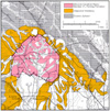
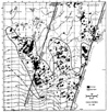
2 - Portion of Fisk's surface geologic map encompassing Little Creek structure
(after Fisk, 1938). Following J.E. Rogers (1982; cf. Figure 7, and Snead and
McCulloh, 1984), the central fill here is tentatively identified as Carnahan
Bayou Member of the Fleming Formation rather than Fisk's original designation of
the unit as Catahoula Formation. Quaternary units not listed in the legend
comprise various Pleistocene terraces (white) and Holocene alluvium (stippled).
Figure
2 - Portion of Fisk's surface geologic map encompassing Little Creek structure
(after Fisk, 1938). Following J.E. Rogers (1982; cf. Figure 7, and Snead and
McCulloh, 1984), the central fill here is tentatively identified as Carnahan
Bayou Member of the Fleming Formation rather than Fisk's original designation of
the unit as Catahoula Formation. Quaternary units not listed in the legend
comprise various Pleistocene terraces (white) and Holocene alluvium (stippled).
Click here to view animation of Figures 3 and 5.
Click here to view animation of Figures 3 and 5.
Click here to view animation of Figure 6 overlain on map of northern Louisiana gas fields.
Contents
Implications for Hydrocarbon Exploration
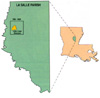
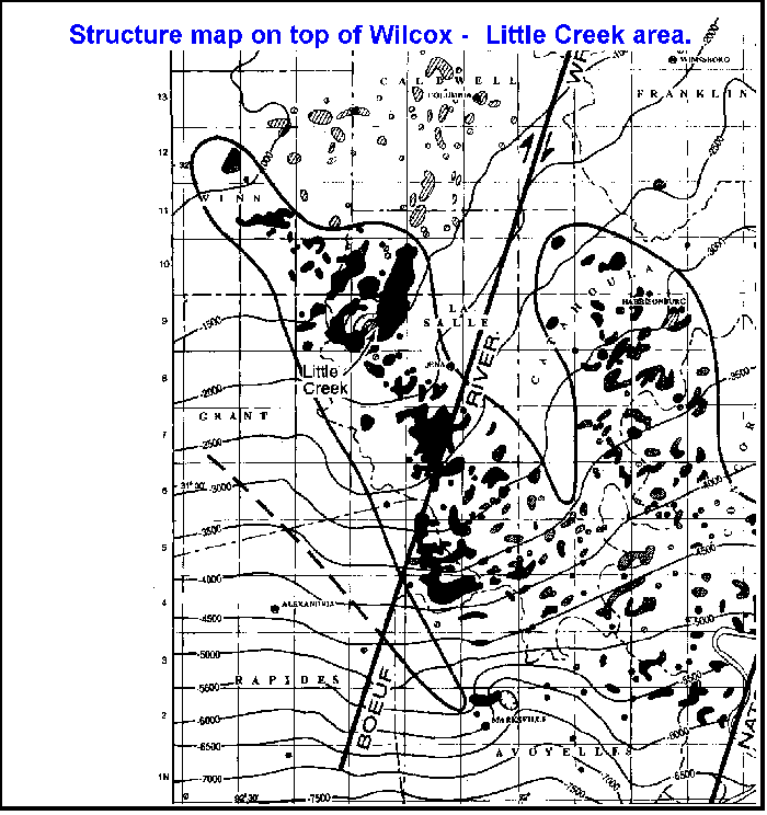
The Little Creek structure is a compact collapse structure approximately 2 miles (3.2 km) in diameter, located in the central part of the west one- half of Township 9 North, Range 2 East, La Salle Parish, Louisiana (Figure 1). At the surface, the Little Creek structure is defined by the collapse area (3 mi2; 8 km2). Sixty years ago, the structure was mapped, described, and reported (Fisk, 1938) by the Louisiana Geological Survey, in conjunction with early geologic mapping of some of the Louisiana parishes. Fisk's (1938) geologic mapping of Little Creek (Figure 2) reveals Miocene strata in the central portion of the surface structure, surrounded by Oligocene Vicksburg beds that, in turn, are surrounded by sediments of the Eocene Jackson (Danville Landing). In addition, in the central area, Little Creek contains Pleistocene terrace-associated strata and Holocene alluvium flanking the courses of southward-flowing streams heading in or passing through the central region of the structure. The structure is ringed, or bounded, by down-to-the-center faulting (Figure 2).
The central strata of the surface structure were originally identified by Fisk (1938) as Catahoula Formation, apparently because of underestimation of the magnitude of the near-surface fault displacement of the structure; more recently, these strata have been identified by well-log correlation as probably belonging to the Carnahan Bayou Member of the Fleming Formation (J.E. Rogers, 1982, personal communication) which is lithologically very similar to the Catahoula. Geomorphically, the surface expression consists of a circularly disposed array of anastomosing, discontinuous ridges. Fisk (1938) indicated it is topographically the highest feature in La Salle Parish.
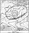
Regionally, the Little Creek structure lies near the northwestern end of the La Salle Arch, which extends approximately 60 miles (100 km) southeast into Avoyelles Parish, Louisiana. Little Creek, in its entirety, is located midway between the Monroe uplift to the northeast, and the Sabine Platform to the west-southwest. The subsurface (domal) expression of-Little-Creek, based on the area of thinning of Upper Cretaceous strata over the structure (Figure 3), is large, having an area of 1785 mi2 (4625 km2). Many Paleocene-Eocene Wilcox and younger oil-producing reservoirs exist above this structure, and along the northwest-southeast trending LaSalle Arch (Figure 3).
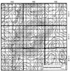
These numerous oil and gas fields have produced since at least the 1920's. In classic form, reservoirs of similar age and lithology provide extensive oil and gas production around the flanks of the larger, subsurface expression of the Little Creek structure. These producing areas are densely drilled, but the surface collapse structure appears to have been drilled by only a few wildcats. An extensive regional residual gravity maximum of township proportions (Figure 4) exists directly beneath Little Creek, covering an area of approximately 70 mi2 (180 km2). The Boeuf River Wrench Fault is 12 miles (19 km) to the southeast (Figure 5).
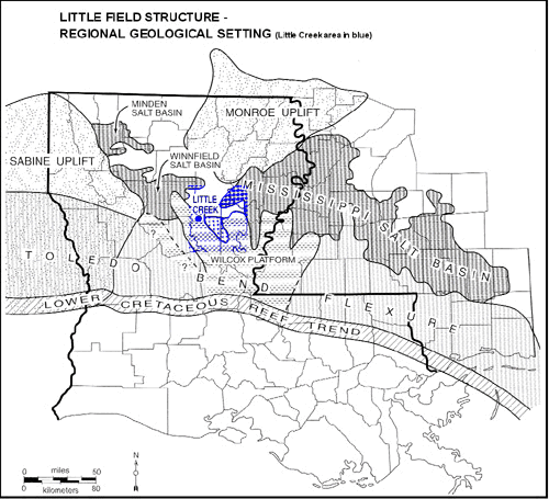
Figure 6 locates the Little Creek structure on the Wilcox Platform (Echols, 1997) as part of the much larger Toledo Bend Flexure (Swain and Anderson, 1993). Figure 6 also locates the position of the LaSalle Arch as part of the Toledo Bend Flexure. Swain and Anderson (1993) state that the salt is thin to absent on the Toledo Bend Flexure. Accordingly, there may be no salt beneath the Little Creek structure. A portion of the southeastern edge of the Winnfield Salt Dome Basin (13 salt domes) may lie in Winn Parish, secs. 15,16,21, and 22, T10N-R1E, approximately 5 miles (8 km) almost directly west of the surface expression of the crest of the subsurface Little Creek structure. It is here that Huner (1939) described the surface expression of the "Castor Creek Saline."
The Castor Creek Saline is described by Huner (1939) as a "white, glaring salt flat, roughly circular, and about one-eighth of a mile in diameter. The surface is covered with clayey sand and salt crystals ....The saline is encircled by a dense growth of palmettoes " (p. 270). He also states that "it resembles in all respects such salines as occur over Drake's salt dome and Cedar Creek salt dome," and "A very peculiar and puzzling fact is that no test wells have been sunk into this saline. Apparently the possible occurrence of an anomalous structure here has not been considered in the development of the Urinal oil field " (p. 270).
The residual gravity map (Figure 4) does not indicate a salt dome at this location. Saline fluids responsible for the accumulation of salt at the Castor Creek Saline may result from leakage of brine from the Cockfield aquifer at the contact with the overlying Vicksburg-Jackson confining unit (J.E. Rogers, 1998, personal communication). Huner (1939) invoked faulting as the means of vertical migration.
The cause of the surface structure of Little Creek may be similar to that of the Magnet Cove structure in central Arkansas as postulated by Byerly (1991) in his report on the igneous activity in the Gulf of Mexico Basin area. He describes this structure and postulates that "the structure of this ring complex may be due to several episodes of cauldron subsidence into a relatively steep-sided magma chamber" (p. 97). He later states: "Numerous magnetic and gravity anomalies have been reported on the Monroe uplift .... These include Epps dome in Louisiana and the Midnight Volcano in Mississippi. These most likely reflect larger igneous complexes in the area" (p. 101; emphasis added).
The likelihood is that, if Little Creek is the result of an igneous event, it probably occurred during Late Cretaceous time, which corresponds with similar events on the Monroe and Jackson uplifts (Byerly, 1991), because Upper Cretaceous and younger strata thin significantly over Little Creek (Figures 3, 7). Thinning is not mapped in older beds below the Upper/Lower Cretaceous unconformity.
Currently, evidence for pre-Upper Cretaceous growth of Little Creek is unknown. Collapse into a magma chamber as described by Byerly (1991) could explain the coincidence of two otherwise seemingly disparate aspects: (1) A drastic thinning of the Upper Cretaceous chalk interval areally restricted to the general vicinity of the surface expression of Little Creek, and (2) the overlying collapse feature. Detailed log correlations reveal missing section in the Upper Cretaceous attributable to an unconformity with discernible angularity. The apparent thickening of Cenozoic strata into the collapse structure causes it to take on the appearance of a growth feature (depending on dip3), in which more than 3,500 feet of displacement can be measured on the base of the Wilcox at the greatest depth of penetration (Figure 7).
3J.E. Rogers has mentioned a potential memory of a conversation with a geologist or other technical professional who was involved in the drilling and/or logging of the Bodcaw #30 LLS Bodcaw Fee well (cf. Figure 7), and who communicated that the diplog run for that well indicated steep dips inside the collapse structure. The authors have thus far been unable to obtain or otherwise examine a copy of this diplog.
Fisk (1938) proposed no hypothesis to account for the origin of the structure. In the time since his investigation, several theories have been advanced as to the origin of Little Creek, but until now none has been published. Those known to the authors are summarized below.
J. E. Rogers (1967; personal communication, 1993) suggested that Little Creek is a salt withdrawal feature resulting from the development of a piercement-type salt dome from which the salt withdrew, causing the structure to collapse upon itself. It is interesting that the structure does appear to lie approximately 5 mi (8 km) from a portion of the suspected southeastern edge of the Winnfield salt dome basin (see Figure 6). The salt withdrawal hypothesis may require as yet unknown salt mechanics peculiar to positioning of the original piercement salt stock near the margin of thick salt to account for such an episode of piracy.
M.D. Butler (1992, personal communication) proposed that the structure is an astrobleme that resulted from a meteor impact that occurred during the deposition of the Upper Cretaceous chalk interval and underwent subsequent collapse. His unpublished section (Butler, 1962), which contains many of the same wells incorporated in Figure 7 herein, identifies the drastic thinning in this interval as corresponding to loss of section, a fact which we confirmed during the construction of our cross sections. In this regard, the feature does classify as a Class IVb cryptoexplosion structure (McCall, 1979); i.e., it is representative of a class of structures "either deeply eroded or buried, or else of considerable complexity, which do not display an immediately apparent physiographic form of meteorite craters" (p. 1), and which are not known to "display some form of shock metamorphism or brecciation" (p. 4).
D. H. Wilson (1994, personal communication), as a student on summer employment with Placid Oil, researched the structure in the late 1970's and concluded from seismic and gravity data that the structure is probably the expression of a deep, post-Jurassic igneous diapir with no salt involvement.
Implications for Hydrocarbon Exploration
The larger, regional expression of the Little Creek structure is shown in Figure 3. It is disclosed by a large area of thinning in the Upper Cretaceous beds (see also Figure 7). Large quantities of oil and gas have been produced from this feature in Wilcox and younger reservoirs. There appears to be no production from within the collapse structure itself, however. The implications are that future exploration might successfully look for residual gravity maximums along and parallel to wrench faulting, such as the Boeuf River Wrench. Where thinning is indicated by either log or seismic data over such anomalies in the Upper Cretaceous, a possible prospect should be considered, regardless of the size of the gravity maximum.
Without seismic data yielding a strong confirmation of an igneous intrusion, the true nature of the Little Creek structure remains unknown. While the senior author favors the igneous intrusion theory, a potential question remains: Is it possible that the structure offers possibilities for a hybrid hypothesis combining two or more of these and other possible influences- W.E. Wilson (1994, personal communication) has stated that the Little Creek structure is still actively subsiding.
James E. Rogers inspired much initial interest in the surface and shallow subsurface Little Creek structure in the early 1980's. He has been a continuing source of essential information, ideas, and discussion on it since then, and reviewed an early draft of this paper. Since the early 1990's, Mark. D. Butler has been a source of equally essential information, ideas, and discussion regarding aspects of the deep subsurface structure coincident with the shallow structure; Figure 7 incorporates many of the wells he used in his early 1960's unpublished dip section. Paul V. Heinrich posted a generalized write-up by McCulloh on the enigmatic nature of the structure, together with a solicitation for nonproprietary data, to relevant internet news groups, and was helpful in McCulloh's making contact with W.E. Wilson. Wilson and his son D. H. Wilson were very helpful in providing essential background regarding Placids interest in and history of investigation of the structure; D. H. Wilson was especially forthcoming with the conclusions of the detailed investigation of the structure he had conducted as a student for Placid. In 1993 Bill Marsalis, incumbent director of the Louisiana Geological Survey, made available to McCulloh copies of the logs used in Figure 7 for correlation. The same year, the late Steve Breakfield encouraged McCulloh's interest in the structure, and provided data he had accumulated pertaining to it.
Butler, M.D., 1962, Unpublished data [dip section through Little Creek]: Jackson, Miss., scales 1 in. = 1 mi (horizontal) and 1 in. = 1,000 ft (vertical).
Butler, M.D., 1992, Personal communication: consulting exploration geophysicist, Jackson, Miss.
Byerly, G.R., 1991, Igneous activity, in A. Salvador, ed., The Gulf of Mexico Basin: Geological Society of America, The Geology of North America, v. J, p. 91-108.
Echols, J.B., 1997, The Wilcox oil province (The Wilcox platform): vertical fracturing caused by basement trends and geopressured source beds: Basin Research Institute Bulletin, Louisiana State University, v. 7, p. 40-49.
Fisk, H.N., 1938, Geology of Grant and LaSalle parishes, Geological Bulletin No. 10: Louisiana Geological Survey, 246 p. plus plates.
Huner, J. Jr., 1939, Geology of Caldwell and Winn parishes, Geological Bulletin No. 15: Louisiana Geological Survey, 356 p. plus plates.
McCall, G.J.H., 1979, Introduction, p. 1-23, in G. J. H. McCall, ed., Astroblemes-cryptoexplosion structures: Benchmark Papers in Geology: Dowden, Hutchinson & Ross, Inc., Stroudsburg, Pa., v. 50, 437 p.
Rogers, J.E., 1967, Unpublished data [shallow subsurface structure and isopach maps of Little Creek and surrounding area from water-well data]: U.S. Geological Survey, Alexandria, La.
Rogers, J.E., 1982, Personal communication, hydrologist: U.S. Geological Survey, Alexandria, La.
Rogers, J.E., 1993, Personal communication: consulting ground-water hydrologist, Alexandria, La.
Rogers, J.E., 1998, Personal communication: consulting ground-water hydrologist, Alexandria, La.
Snead, J.I., and R.P. McCulloh (compilers), 1984, Geologic map of Louisiana: Louisiana Geological Survey, scale 1:500,000.
Swain, F.M., and E.G. Anderson, 1993, Stratigraphy and Ostracoda of the Cotton Valley Group Northern Coastal Region, Geological Bulletin No. 45: Louisiana Geological Survey, 150 p.
Wilson, D.H., 1994, Personal communication, petroleum geologist, Vastar Resources, Houston, Texas.
Wilson, W.F., 1994, Personal communication, geologist, Strata Environmental, Spring, Texas.