 Click to view poster in PDF format (~5.3 mb).
PSThe Future Oil Discovery Potential of the Mackenzie/Beaufort Province*
By
Zhuoheng Chen1, Kirk Osadetz1, James Dixon1, Giles Morrell1, and J.R. Dietrich1
Search and Discovery Article #10133 (2007)
Posted September 3, 2007
*Adapted from poster presentation at AAPG Annual Convention, Long Beach, California, April 1-4, 2007. National Resources Canada ESS contribution number: 20070247.
1Geological Survey of Canada, Calgary, AB ([email protected])
The Mackenzie/Beaufort province hosts large quantities of proven and potential petroleum resources that are of strategic importance for future North American energy supply. Petroleum exploration in the province has resulted in 53 distinct accumulations in 48 significant conventional crude oil and gas discoveries (National Energy Board, 1998). The discovered quantities of conventional petroleum resources are estimated to be 1.744 x 10⁹ bbls (277.3 x 10⁶m3) recoverable crude oil and 11.74 tcf (332.4 x 10⁹m3) recoverable natural gas (Dixon et al., 1994). Recent studies of unconventional petroleum resources indicate that an immense natural gas potential exists in the form of methane hydrate in this province (e.g., Osadetz and Chen, 2005).
|
|
The Mackenzie/Beaufort province (Figure
1) exhibits a complex basin evolution (Figure
2A), from an open marine setting throughout most of the
Paleozoic, followed by a rift-drift system in Jurassic to Early
Cretaceous. The Late Cretaceous-Cenozoic successions represent a
post-rift passive-margin basin comprising more than 14 km of deltaic
sediments (Dixon et al., 1992), complicated by the Cordilleran
Thrust Belt in the west. Tectonically, the province can be divided
into four
This study is based on the previous
petroleum resource assessment conducted by the Geological Survey of
Canada (GSC) (Dixon et al., 1994), with emphasis on the
petroliferous rifted basin margin and the southern part of the
Canada Basin, extending from south of the Mackenzie Delta, north to
about 2500 meter water depth because this is the most accessible
region for exploration and development. Areal extent of the
assessment and boundaries of the
Three major potential source rock sets may
exist in this province: a) the Jurassic-Lower Cretaceous syn-rift
shales, b) Upper Cretaceous passive margin marine shales, and c)
Tertiary passive margin marine shales. The syn-rift Jurassic-Lower
Cretaceous successions may have three potential source beds. Shale
in the Husky Formation is found in the southeast basin margin and
nearshore areas, and it is also possibly present in some of the
deeply buried grabens in the shelf area. If the rotational model of
Arctic plate tectonics is valid, the syn-rift Jurassic-Lower
Cretaceous (J-lK) successions should also be present in the west
Beaufort Sea. Oil and source rock correlation indicates that this
shale could be a major contributor of natural gas in the Parsons
Lake gas field and Unak gas discovery (Langhus, 1980). The Lower
Cretaceous Arctic Red Formation, found in the Kugmallit Trough in a
slope to basinal environment (Dixon et al., 1994), is presumably
present in most of the province and represents sedimentation during
the last phase of continental drifting. Recent organic geochemical
analyses indicate biomarker signatures from the Arctic Red shale in
a number of discoveries (Li, personal communication, 2006).
Localized source rock, such as the Lower Cretaceous McGuire shale,
is inferred to be responsible for oils found in the Kamik discovery
well and adjacent areas (Dixon, personal communication). It may also
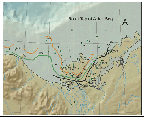
be present in the offshore area. Source rock maturity studies (see Figure
5) indicate that the J-lK source rocks could be one of the
sources for the Rifted Margin, Taglu Delta and Kugmallit Delta The Upper Cretaceous succession of the Boundary Creek and Smoking Hills formations represents the earliest sedimentary records accumulated in outer shelf and slope environments of this passive margin basin and contain organic-rich and radioactive shales, which are widely distributed in the Arctic region. These shales are recognized to be one of the major contributors to the oils found in the discoveries in the Tuk, Atkinson and Mayogiak wells, in the central and northern Tuktuyaktuk Peninsula (Dixon et al., 1994; Dixon et al., 1985). Biostratigraphic data and new 3D seismic interpretation indicate that the uK mobile substrata cores some of the shale diapirs (Bergquist et al., 2003) in the west Beaufort Sea, and part of the uK source rock could still be in the hydrocarbon generation window in part of the offshore area.
The Lower Tertiary succession contains
several organic-rich shale intervals in the major sequences, such as
Richards, Taglu and Aklak, and are inferred to be responsible for
some of the oil and gas accumulations found in this province (Snowdon,
1984; Snowdon et al., 2004; Brooks, 1986). Where it is mature, the
Tertiary succession is considered to be one of the major source
rocks for the accumulation in the deep/ultra deep-water setting.
Analyses of the measured vitrinite reflectance from cuttings and
cores indicate that the maturity level of the Lower Tertiary
succession has reached the oil window just below 3000 meters
(Ro>0.6%) in the Richards Island and western Beaufort Sea. The
vitrinite reflectance reached 0.6% at top of the Aklak Sequence in
Richards Island and offshore areas. The oil correlations indicate a
good correspondence between the oils from the Adlartok P-09 well and
Tertiary source rocks (Li, personal communication). It is
anticipated that the Lower Tertiary shales and coal seams are the
major sources for the oil and gas accumulation in the west Beaufort
Sea Organic geochemical analyses indicate a large range of variation in TOC% measured from cuttings and side wall cores in exploration boreholes at almost all stratigraphic levels. Although most samples have a TOC% <3%, a number of stratigraphic intervals show a fairly high TOC, up to 9%. Figure 3 displays histograms of TOC% from nine stratigraphic levels, showing the variations. Results from Rock-Eval analysis suggests a diversity of kerogen types in the basin. Figure 4 is a cross-plot set of hydrogen index vs. oxygen index of borehole cuttings from nine stratigraphic intervals, suggesting predominant type II and type III kerogen in this province. Vitrinite reflectance was measured from cuttings and cores in ninety two wells (green dots, Figure 5). Maturity level increases basin-wards at the top of the Aklak Sequence; whereas it increases northwest-wards for the Mesozoic and older strata. Figures 5a - e show maturity trends at tops of five different stratigraphic levels, indicated by the vitrinite reflectance (Ro) contours. Figure 5f is a Ro contour map at a depth of 3000 meters, showing the spatial variation of the basin thermal heterogeneity.
Petroleum system modeling suggests multiple phases of petroleum generation and migration from potential source rocks at different burial depths. Significant petroleum generation/migration may have started as early as Late Cretaceous and continued to rather recently, depending upon the thermal history of the source rocks. Figure 6 shows results from 1D modeling at four synthetic well locations, illustrating hydrocarbon generation/expulsion histories in different parts of the basin. In the west Beaufort Sea, the Tertiary sources appear to be the effective source rocks because of the high thermal maturity level, whereas the Cretaceous and older source rocks have all passed through oil window and the oils were expelled before the major phase of trap formation in the late Eocene. In contrast, in the southeast part and deep-water portion of the basin, the Cretaceous source rock seems to be the major contributor because of either a shallow burial depth of the Tertiary source rocks in the rifted margin or a low level of maturity in the Tertiary depocenters. Faults/fracture zones associated with mobile substrata, listric and thrust fault systems provide adequate vertical migration routes. However, fluid migration and entrapment are dynamic processes throughout the entire basin development history. The episodic nature of overpressure and pressure release may have led to loss/partial loss or redistribution of early accumulated hydrocarbons. Several episodes of tectonic activity in the Tertiary are recognized in this province (Lane and Dietrich, 1998). The most important ones include tectonic inversion during the Late Eocene, which led to diapirism and trap formation over a wide area. While in the eastern part, the same tectonic episode reactivated the pre-existing faults and generated roll-over structures. Tectonic activity at the end of the Miocene may have triggered large scale submarine sliding and formed turbidities and basin-floor sheet sands over a wide area. Tectonic activity at the end of the Miocene may have accelerated the secondary migration process and caused re-migration of some previously trapped hydrocarbon accumulations.
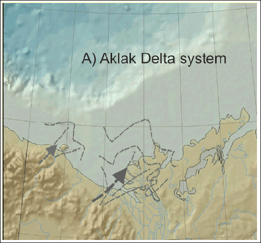
In the Tertiary basin-fill history, five
major delta systems developed (Figure 2A).
Figure 7 shows four of the major delta
systems, illustrating the extent of each of the systems, and how the
delta systems evolved in time and space in response to tectonism,
and depositional provenances. The shape and areal extent of each
individual delta system is defined from the 20% and 30% sand content
derived from borehole logs. The major delta systems cover almost the
entire present continental shelf and Richards Island. The deltaic
sandstones of delta plain and delta front provide quality reservoirs
for hydrocarbon accumulations in the Taglu Delta, Kugmallit Delta,
and West Beaufort Sea
Additional types of reservoir rock include
channel-fill sandstones and submarine-fan sands in recent as well as
paleo-slope and deep-water basins. Interpretation of the newly
acquired 3D seismic data indicates the existence of large scale
channel-fill sandstones in the Richards Sequence (Bergquist et al.,
2003) in the west Beaufort Sea (Figure 8).
The Oligocene and Miocene sequences are shale-dominant in general,
and they may also contain channel-fill sandstones or other type of
sand bodies. For example, clinoforms (Figure 41 of Dixon et al.,
1985; Figure 11b and 13 a and b of Hubbard, et al., 1985) and
channel forms (seismic profile 8E of Dixon et al., 1990) on seismic
lines in the Mackenzie Bay Sequence indicate delta front, delta
plain and channel sands. Sandstones associated with submarine fan
systems in the Iperk, Mackenzie Bay and Kugmallit sequences are the
major reservoir type in the Basinal facies
In the deep-water
For the Rifted Margin
Several types of traps have been
recognized in this region.
Stratigraphic traps are recognized in this
province. Unconformity traps are interpreted from seismic data, and
pinch-out is an important component for several discoveries made in
the basinal facies
The shale-dominant Richards, Mackenzie Bay and Akpak sequences are regional top seals in this area. The shales in this region may contain substantial amount of silts, which may affect the seal capacity.
The seal integrity may be at risk for some
of the diaper-cored anticlines because diapirism, overpressure, and
associated crestal faulting/fracturing may have weakened the top
seal. Note the shallow overpressure zone in the basinal facies
Eighteen plays were defined based on the
trap configurations and reservoir age/types, among which fourteen
are identified or inferred to have oil potential.
Figure 2C shows the stratigraphic and
predominant trap type of the plays/
These fourteen plays were assessed
separately for oil, and the resources were then aggregated into
Figure 12a to
f are cumulative distributions of the aggregated
Given the large undiscovered oil resource potential, the future discovery growth in this province is expected to come from:
Only a part of the entire Mackenzie/Beaufort province prospective sedimentary succession is the subject to this petroleum resource potential appraisal. Our focus is limited to the region south of continuous pack ice and restricted to the shallow part of the total sedimentary succession (largely in the Tertiary succession). This reflects the current, early exploration history stage of this province. It is expected that there will be both increased data and understanding that will lead to new large discoveries in the more remote areas and deeper parts of the sedimentary succession as the scope of exploration expands both geographically and technologically. The discovery and reserve growth patterns of the Mississippi Delta petroleum province, where very large accumulations continue to be found as exploration expands into the geographically remote, deep water and technologically challenging parts of the Gulf of Mexico, may provide a useful analogy for the future exploration outlook and overall potential of the Mackenzie/Beaufort province.
Bergquist, C.I., Graham, P.P., Johnston, D.H. and Rawlinson, K.R., 2003, Canada's Mackenzie Delta: Fresh look at an emerging basin, Oil and Gas Journal, v. 101, Nov. 3, p. 42-46.
Dixon, J. and Dietrich, J.,
1990, Canadian Beaufort Sea and adjacent land areas, in
Grantz,A., Johnson,L., and Sweeney, J.F., The Arctic Ocean Region,
The
Dixon, J. Dietrich,J.R.,
McNeil,D.H.Snowdon,LR., and Brooks,P., 1985, Dixon, J. Deitrich, J., and McNeil, D.H., 1992. Jurassic to Pleistocene sequence stratigraphy of the Beaufort - Mackenzie Delta and Banks Island areas, Northwest Canada: Geological Survey of Canada, Bulletin 407, 90p. Dixon, J, Morrel, G.R., Dietrich, J. R., Taylor, G.C., Procter, R.M., Conn, R.F. Dallaire, S.M., and Christie, J. A., 1994, Petroleum resources of the Mackenzie Delta and Beaufort Sea; Geological Survey of Canada, Bulletin 474, 52p.
Enachesu, 1990, Harper, F., 2005, The future of global hydrocarbon exploration: APPEX, March 2005. Hubbard, R., Pape, J., and Roberts D.G., 1985, Depositional sequence mapping to illustrate the evolution of a passive continental margin, in Berg, O.R., and Woolverton, D.G., eds., Seismic stratigraphy II: an integrated approach to hydracarbon exploration: AAPG Memoir 39, p.93-105. Klett, T.R., Gautier, D.L. and Ahlbrandt, T.S., 2005, An evaluation of the U.S. Geological Survey World Petroleum Assessment 2000: AAPG Bulletin, v. 89, p.1033-1042.
Lane, S.L. and Dietrich,
J.R. 1995, Tertiary National Energy Board, 1998, Probabilistic estimate of hydrocarbon volumes in the Mackenzie Delta and Beaufort Sea discoveries, 9p.
Osadetz, K.G., and Chen,
Z., 2005, A re-examination of Beaufort Sea-Mackenzie delta basin gas
hydrate resource potential using a petroleum Saller, A., Lin, R., and Dunham, J., 2006, Leaves in turbidite sands: the main source of oil and gas in the deepwater Kutei Basin, Indonesia: AAPG Bulletin, v.90, p.1585-1608. Stepheson, R., 1996, Crustal velocities and thickness , - Campbell Uplift to southern Beaufort Sea Shelf edge, in Geological Atlas of the Beaufort-Mackenzie Area, (ed.) J. Dixon: Geological Survey of Canada, Miscellaneous Report 59.
Snowdow, L.R., 1987,
Organic properties source potential of two early Tertiary shales,
Beaufort-Mackenzie Basin: Bulletin of Canadian Petroleum Weimer P., and Slatt, R.M., 2004, Petroleum systems of deepwater settings: European Association of Geoscientists & Engineers (EAGE) Distinguished Instructor Series, No. 7, Society of Exploration Geophysics, Tulsa, USA.
|


