|
uAbstract
uFigure
captions
uGeneral
comments
uTheories
uGeologic
setting
u Oil Oil sands of Alberta
uCoal
of Alberta
uCoalification
uBituminization
uChemical
factors
uTectonism
uSummary
uConclusions
uAddendum
uBitumen
uGlacial
ice
uBotany
uTectonism
uReferences
|
Figure Captions
|
 |
Figure 1. Generalized Western Canada
basin wedge, with principal oil and gas-reservoirs (from Porter,
1992). |
|
 |
Figure 2. Generalized facies distribution
in parts of the lower, middle, and upper Mannville (from Cant,
1989). A. Upper part of lower Mannville. B. Transgressive middle
Mannville. C. Upper Part of upper Mannville.
Reproduced with the
permission of The Canadian Society of Petroleum Geologists and of
the Minister of Public Works and government Services Canada, 2004,
and Courtesy of Natural Resources Canada, Geological Survey of
Canada. |
|
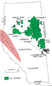 |
Figure 3. Index map of
oil sands, carbonate triangle, heavy oil, and deep-basin gas (from
Proctor et al., 1983). Reproduced with the permission of the
Minister of Public Works and government Services Canada, 2004, and
Courtesy of Natural Resources Canada, Geological Survey of Canada. |
|
 |
Figure 4. Schematic section showing oil
trapped in sands and carbonates (from Proctor et al., 1983).
Reproduced with the permission of the Minister
of Public Works and
government Services Canada, 2004, and Courtesy of Natural
Resources Canada, Geological Survey of Canada. |
|
 |
Figure 5. Schematic diagram of regional
groundwater flow and salt collapse (from Page, 1974). Reproduced
with the permission of the Canadian Society of Petroleum
Geologists. |
|
 |
Figure 6. Correlation chart of Lower
Cretaceous heavy oil deposits (from Jardine, 1974). Reproduced
with permission of the Canadian Society of Petroleum Geologists. |
|
 |
Figure 7. Stratigraphic cross-section
through sedimentary basin of southern Alberta and southeastern
British Columbia (from Poulton, 1989). Reproduced with permission
of the Canadian Society of Petroleum Geologists. |
|
 |
Figure 8. Isoreflectance contours of
Bluesky-Gething coal of Alberta and British Columbia (Grande Cache
to Pink Mountain) (from Hacquebard and Cameron, 1989). Reprinted
from International Journal of Geology, v. 13, p. 207-260, with
permission of Elsevier. |
|
 |
Figure 9. Maceral distribution for Mist
Mountain, Gething, Gates, and Coalspur units (from Cameron and
Smith, 1991). Reprinted from Journal of
Coal Geology, v. 19, with
permission from Elsevier and with the permission of the Minister
of Public Works and government Services Canada, 2004, and Courtesy
of Natural Resources Canada, Geological Survey of Canada. |
|
 |
Figure 10. Van Krevelen diagrams and
evolutionary paths of kerogen macerals (from Mukhopadhyay and
Hatcher, 1993). |
|
 |
Figure 11. Evolution of molecular
fraction of a vitrinite-rich coal during coalification (from
Levine, 1993). |
|
 |
Figure 12. Relation between maturation of
oil source rocks and bituminization of coal (from Boreham and
Powell, 1993). |
|
 |
Figure 13. Van Krevelen diagram showing
kerogen paths and products of maturation (from Tissot and Welte,
1978). |
|
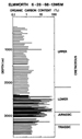 |
Figure 14. Organic content of a well in
the Elmworth field (from Welte, 1984). |
|
 |
Figure 15. Chromatograms of the saturate
fraction in selected Early Cretaceous oil from wells in eastern
Alberta (from Jardine, 1974). Reproduced with permission of the
Canadian Society of Petroleum Geologists. |
|
 |
Figure 16. Schematic profile,
characteristics, and environment of a Texas lignite (from
Mukhopadhyay and Hatcher, 1993). |
|
 |
Figure 17. Distribution of terrestrial
(waxy) oil source with respect to geologic time (from Clayton,
1993). |
Return to top.
General Comments
The problem of a source rock
for the huge reserves of bitumen in Alberta's oil sands has been a
contentious issue for geologists and geochemists for decades. Many
theories have been proposed, and these are summarized in the following
section.
There are about 1.67 trillion
barrels of heavy crude in the oil sands. Unless one favors an in situ
origin, the oil must have migrated from west to east along a pathway
with adequate porosity/permeability characteristics, This is generally
accepted to be the sub-Cretaceous unconformity. The bitumen could not
have migrated far in its present condition, so it has likely been
altered by biodegradation, water-washing, oxidation, and reduced
salinity of formation water. These concepts are accepted by most
geoscientists. However, the question of source has remained a divisive
issue.
The commonly accepted origin
for the oil-sands bitumen are Triassic and Jurassic marine shales and/or
carbonates of Devonian and Mississippian ages. These strata are beveled
at the sub-Cretaceous unconformity. They are known sources of
conventional crude; so the assumption that they sourced the oil sands is
a logical.one. However, as described later, conventional marine sources
are inadequate to account for the huge volume of oil-sands crude. The
probability of a continental source was proposed by Masters (1984). It
is the purpose of this paper to suggest that the main source for the
huge reserves of heavy oil is the equally immense coal deposits of the
mountains and foreland basin. Arguments are presented in favor of this
theory.
In 1974, I presented a paper
to Chevron geologists in Calgary and to Chevron Oilfield Research
Corporation geoscientists at La Habra, California. It was entitled
"Origin of the Lower Cretaceous Heavy Oils of Alberta" (April, 1974). In
it I suggested that that the Upper Jurassic Kootenay and Lower
Cretaceous Luscar coals and carbonaceous shales were the main source of
Alberta's oil-sands crude. It was well received by many of the
geoscientists, but because of its speculative nature, it remained
unpublished. Since then, new information about coal macerals and their
relationship to oil generation tend to support my original suggestion.
The number of theories
proposed for the source of oil-sands bitumen is indicative of the degree
of controversy in the geological profession (Conybeare, 1966; Vigrass,
1968; and others). For the purpose of this section, I have used a
modified tabulation of the theories listed by Vigrass for the first six
on the list, with later additions from other sources. The main theories
of origin for Alberta's oil sands are:
1. Oil escaped through
fissures from Devonian reservoirs during or since Early Cretaceous
(Link, 1951; Sproule, 1951).
2. Derived in situ from organic material deposited with the sand (Hume, 1951; Corbett, 1955).
3. Derived from shales of the
Clearwater Formation, age equivalent to the McMurray Formation (McLean,
1917; Ball, 1935; Hitchon, 1963).
4. Originally, light oil that migrated from the deep basin and was later altered to heavy crude (Gussow, 1956).
5. Oil was derived from materials leached from soils into McMurray sandstones and subsequently converted to heavy hydrocarbons (Hodgson and Hitchon, 1965).
6. Hydrocarbons which moved
out of the deep basin in micellar or colloidal solution in compaction
waters and were “precipitated” on anticlinal structures or sand
pinchouts perhaps due to a salinity change (Vigrass, 1968).
7. Sand and oil deposited together from a breached Paleozoic reservoir (Gallup, 1974).
8. The heavy oils were
emplaced by upward migration of inorganic petroleum via deep faults
which extended into the mantle (Porfir'ev, 1974). It is noted that this
inorganic theory has been tested by a well drilled into the Precambrian
granite by C. Warren Hunt, with negative results.
9. Oil was sourced from Lower Cretaceous, Jurassic and Triassic carbonaceous shales (Masters, 1984).
10. Oil was likely sourced
from basinal Jurassic and cratonic Devonian-Mississippian strata
(Porter, 1992).
11. The theory presented here
is that oil was generated from Upper Jurassic and Lower Cretaceous coals
during the bituminization phase of the coalification process, mainly
between high and low volatile bituminous rank. This temperature range is
the same as the "oil window" for conventional marine source rocks. Coal
is simply a nonmarine equivalent with huge oil-generating potential. It
was source for the immense oil-sands reserves of Alberta.
Geologic Setting
This paper is concerned
primarily with the Upper Jurassic / Lower Cretaceous strata of the
mountains and foreland basin of central Alberta, and the eastern
equivalent in the plains region (Mannville Group). The following is a
brief overview of geological events as they relate to the current paper.
Figure 1 (from Porter, 1992)
is a stratigraphic column showing the main post-Paleozoic units.
Prominent is the sub-Cretaceous unconformity which beveled earlier
strata. From Early Paleozoic to Jurassic, the Alberta craton had been
dominated by marine carbonates and clastics, Devonian reefs and
evaporites. This lengthy period of quiescent marine sedimentation ended
in latest Jurassic time with the first signs of rising land in the
Cordillera (Columbian orogeny). Transition from marine to continental
sedimentation occurred first in southeastern British Columbia and
southwestern Alberta, where Fernie marine clastics pass upwards into
uppermost Jurassic and Lower Cretaceous nonmarine sequences. The
transition progressed from south to north, reflecting a northward
migration of orogenic activity. These nonmarine sequences include major
coal-bearing intervals in the Upper Jurassic / Lower Cretaceous Kootenay
Group of southwest Alberta and southeast British Columbia, the Luscar
and Nikanassin (Blairmore) Group of west-central Alberta, and the
Gething-Gates (Bullhead) Group of northwest Alberta.
Uplift during the Columbian
orogeny created a narrow, deep, foreland basin of deposition. A major
drop in base level in Early Cretaceous initiated a widespread erosional
interval that truncated earlier formations from Late Jurassic through
Devonian in age. This sub-Cretaceous (sub-Mannville) unconformity was
overlain by sands and conglomerates of the Cadomin/Gething/Mannville
formations. These relatively permeable beds provided a conduit for updip
migration of basinal fluids and hydrocarbons from source to oil-sand
host rocks. Deltaic, fluvial, and swampland deposits dominated much of
Mannville sedimentation. Paleozoic carbonate highlands on the
sub-Cretaceous unconformity influenced river drainage patterns and
swampland vegetation.
Clastic input to the basin
and plains regions came from both the Cordilleran uplift in the west and
the Precambrian shield in the east. Nonmarine (lower and upper Mannville)
sediments were separated by a shallow marine (brackish) interlude as
shown in Figure 2 (from Cant, 1989). This figure also shows the
Paleozoic highlands on the sub-Mannville unconformity, one of which
trapped the Peace River heavy oil deposit. Pulses of uplift in the
Cordillera supplied vast quantities of clastics to the rapidly subsiding
foreland basin.
Following the dominant
nonmarine sediments of the Mannville group, a merging of seaways from
the Arctic and the Gulf formed a shallow epicontinental sea across
Alberta. Increasing Cordilleran tectonism in Late Cretaceous and
Tertiary times (Laramide orogeny) supplied huge quantities of sediments
to the foreland basin; much of this section has since been lost to
erosion. Overthrusting of Lararnide tectonism deepened the foreland
basin, supplied large quantities of sedimentary load, and applied
eastward-directed dynamic pressure to basinal fluid systems.
The main heavy oil areas of
central Alberta are the Athabasca-Wabasca, Peace River, and Cold Lake
fields with numerous smaller ones, as shown in
Figure 3 (from
Proctor et al., 1984). They cover an area of some 75,000 square kin
(29,000 square miles) in central Alberta (Porter, 1992). Also shown are
the heavy oils of the Lloydminster fields which are chemically related
to the oil-sand bitumen.
The estimated initial volume
in-place of oil-sands bitumen is given as 269.8 billion cubic meters
(1.698 trillion barrels) by the Alberta Energy and Utilities Board
(1998). There are almost 450 billion barrels in subcropping Paleozoic
carbonates (Carbonate Triangle). The carbonate oil has the same chemical
characteristics as the overlying Mannville sand oil, suggesting it has
soaked into the carbonates from above. Figure 4
(from Proctor et
al., 1984) shows the oil sands and underlying carbonate oil. Instead of
impregnation from above, it has also been interpreted as a breached
Devonian reservoir (Gallup, 1974).
The Alberta Energy and
Utilities Board (1998) lists the initial established reserves of
conventional crude oil in Alberta as 2,490.100,000 cubic meters
(15,662,700,000 barrels). By comparison, the same report lists the
initial volume in place of crude bitumen in Alberta's heavy oil deposits
as 269,800,000,000 cubic meters (1,698,000,000,000 barrels).
From EUB figures it is clear
that the conventional oil reserves of western Canada comprise only about
I percent of the total bitumen in the oil sands. This is more than 4
times the proven reserves of the Middle East, based on 1976 figures.
Masters (1984) comments that the huge reserves of Lower Cretaceous oil
and gas in the western Canada sedimentary basin make them the richest
hydrocarbon province in the world. It should also be noted that large
quantities of oil sands have been lost by erosion and degradation; these
would have greatly increased the estimated initial in-place reserves.
This enormous discrepancy between conventional and non-conventional oil
reserves is of primary importance in the present discussion.
The gravity of oil-sands
bitumen is low and ranges from 6 to 18 degrees API. The gravity is
roughly related to depth and water salinity (Jardine, 1974) The oil
sands are largely unconsolidated, with high porosity/permeability
values. Distribution of sands on the sub-Cretaceous unconformity is
related to fluvial-deltaic patterns and influenced by Paleozoic
carbonate topography. Solution of underlying Devonian salt accounted for
local areas of thicker oil-bearing sands, as shown in
Figure 5
(from Page, 1974). Figure 6 (from Jardine, 1974) illustrates the
intervals of heavy oil saturation in Mannville sands and the schematic
relationship to pre-unconformity strata from Jurassic to Devonian.
In discussing the oil sands
of Alberta, it is important not to overlook the heavy-oil fields of
Saskatchewan (below 19 degrees API). The estimate of original oil in
place is 2,294, 929,000 barrels or 36,486,565 cubic meters (White,
1974). It is interesting that the bulk of these heavy oilfields are at
the same stratigraphic horizon as Alberta's oil sands (the Mannville
formation), suggesting the likelihood of a common source.
It is not the purpose of this
paper to dwell on the geology of the oil sands. It is sufficient to
emphasize that some two trillion barrels of heavy oil occur at or near
surface in the oil-sands deposits of Alberta. This gigantic reserve
requires an equally gigantic source. It is the aim of this paper to
suggest that this source is primarily the Lower Cretaceous and Upper
Jurassic coals of the foreland basin.
This paper deals only with
the Upper Jurassic and Lower Cretaceous coals of Alberta, and British
Columbia, - the Kootenay group in the south, the Luscar group of central
Alberta; and the Gething-Gates group in the north. They form a long
linear series of exposures in the mountain and foothills regions of the
disturbed belt. The coal is exposed in thrust sheets of the Laramide
orogeny. Seams of up to 13 meters thick are reported (Cameron and Smith,
1991).
The Kootenay group of
continental sediments overlie the Fernie group of marine shales and
transitional (Passage) beds and are truncated by the Lower Cretaceous
unconformity as shown in Figure 7 (from Poulton, 1989) which also
emphasizes the coal-bearing character of the Mist Mountain formation of
the Kootenay group. Huge coal deposits are also present in the central
Luscar and northern Gething-Gates groups.
For the purpose of coal
tonnage estimates, Alberta is divided into three regions - Mountains,
Foothills, and Plains. The in-place resource estimated by the Energy
Resources Conservation Board (1993) is as follows. Numbers are in
gigatonnes (billions of tonnes).
Mountain region 24
Foothills region 14
Plains region 2000
Coals of the Mountain region
are mainly low and medium-volatile bituminous; those of the Foothills
region mainly high-volatile bituminous-, and those of the Plains mainly
sub-bituminous (ERCB, 1993). In general, rank increases and volatiles
decrease from basinal plains through foothills to mountains.
It is clear that by far the
largest tonnage is in the Plains region. This estimate includes coals
younger than Lower Cretaceous, but it is noted that of the 2000
gigatonnes of the Plains, at least 628 billion tonnes are within the
Mannville Formation (Yurko, 1976) and that Mannville coalbeds range in
depth from 1500 feet (457 in) in the northeast to 8000 feet (2438 in)
along the margin of the Foothills. Thus there are more than 650 billion
tonnes of estimated coal within the Upper Jurassic / Lower Cretaceous
strata of the sedimentary basin, all correlatable with, or having access
to, the host beds of the oil sands. Disseminated carbonaceous material
within the sediments is unknown but must be huge. According to Hunt
(1979) the vitrinite (coal) maceral may constitute up to 80% of clays
and sands of sedimentary origin. If so, this makes the oil-generative
potential of vitrinite of prime importance in the present discussion.
Coalification
Kerogen is the dominant
organic matter in sedimentary rocks. It is insoluble in most acids,
bases, and organic solvents. It does not include bitumen. Macerals are
the microscopic constituents of kerogen. There are three main coal
maceral groups:
·
Liptinite or exinite (high content of algal or spore
material, strongly sapropelic, fluorescent, boghead and cannel coals,
relatively rare).
·
Vitrinite or huminite (forms the major part of humic
coals, angular to sub-angular, fluorescence weak or absent).
·
Inertinite (angular, may show cell structure, high
reflectance, no fluorescence, sometimes considered oxidation products of
fires).
It should be noted that due
to physical-chemical changes, this typing may be too rigid.
Fundamental to the subject of
oil from coal is the process of coalification. Coalification is the
natural maturation of coal in its passage from peat to anthracite.
Organic matter matures progressively from peat through lignite,
sub-bituminous, high-volatile bituminous, medium-volatile bituminous,
low-volatile bituminous, semi-anthracite, and anthracite. The rank is
measured microscopically by the reflectance--in-oil of the coal maceral
vitrinite. Reflectance increases with increases in temperature
(increasing burial depth) and is usually indicated as %Ro. Once the
highest stage of reflectivity (Rmax) is reached, it cannot be reversed.
It represents the highest temperature that rock was subjected to during
its geological history and is the basis for estimating the thickness of
strata that have been removed by erosion since its maximum burial
depth.
Lignite is the first stage in
coalification following its origin as peat. It is high in volatiles
including water, carbon dioxide, certain acids, and nitrogen. A small
amount of methane and heavy bitumen may be formed in the first few
hundred meters of burial (Hunt, 1979). In this regard it is interesting
to note that the inertinite maceral (generally rejected as having any
oil potential) may have been able to generate liquid hydrocarbon as
early in the coalification stage as Ro% 0.2 to 0.5 (Smith and Cook,
1984). In other words, its "barren" reputation may be because inertinite
had already expelled any bitumen it once contained.
During compaction and
diagenesis, there is a rapid loss of water and other weakly-held
volatiles (dehydration) and a slow build-up of hydrocarbons from lignite
into the sub-bituminous rank. Maximum generation of volatiles occurs
between the high- and low-volatile bituminous ranks (catagenesis). This
occurs within a narrow temperature range between 80-100o and
120-150 oC. (Boreham and Powell, 1993). This correlates to
vitrinite resistivities of about 0.5 to 1.3, the "oil window" of
traditional (marine) source rocks. Above about 1.3%Ro (metagenesis), the
coal progresses into the wet gas zone, and at about 2.0%Ro production is
dry methane gas.
Figure 8, from Hacquebard and
Cameron (1989), is an isoreflectance map of coals from the basal
Bluesky-Gething Formation of NW Alberta / NE British Columbia as
measured from drillhole recoveries. The values range from a reflectance
of less than 1.1 to a maximum of more than 2.5, with the highest values
in the deep foreland basin. Vitrinite reflectance is also used to
evaluate the maturation stage of traditional source rocks. The optimum
oil-generative capacity (the "oil window") lies between reflectivities
of 0.5 to 1.3. It is, therefore, clear that during the coalification
process, temperatures in the deep basin reached, and exceeded, the "oil
window" range. Any oil generated from the coal would have been expelled
prior to the metagenesis (overmature) phase.
The three main coal macerals
- liptinite (exinite), vitrinite, and inertinite - are listed in
decreasing order of oil-producing potential. The maceral character of a
coal is commonly shown as a triangle with a maceral type at each comer.
Figure 9, from Cameron and Smith (1991), is a triangle plot of maceral
distribution for three of the subject coals (Jurassic Mist Mountain and
Lower Cretaceous Gething and Gates). These show a high proportion of the
vitrinite maceral trending towards inertinite - components commonly
interpreted as gas-prone. This opinion has been questioned. Boreham and
Powell (1993) list a number of recent workers who have observational
evidence that oil has been generated and expelled even from
low-potential (Type III) organic matter. Concerning generalizations
about gas or oil potential of specific macerals, Boreham and Powell
(1993) have this to say: "These generalizations, which have wide
currency, have inhibited the development of an understanding of the
source-rock potential in carbonaceous sequences. In fact, there is no
clear relationship between petrographic type and petroleum potential in
humic coals." To add to this quandry, as they point out, is
heterogeneity of macerals types in humic coals. Vitrinite changes
chemically (colour and fluorescence) during higher stages of
coalification owing to generated liquid hydrocarbons (Mukhopdhyay and
Hatcher, 1993). Furthermore, beyond a reflectivity of about 1.1,
vitrinite is difficult to distinguish from liptinite (Levine, 1993). It
thus seems that assigning a gas-prone character to vitrinite is
misleading. Littke and Leythauser (1993) conclude that "coal can be
regarded as a moderate- to poor-quality oil source rock." However, given
the huge amount of vitrinite in sedimentary rocks, the overall
contribution could be overwhelming, particularly for the organic-rich
Jurassic / Lower Cretaceous coals in this study.
Oil-potential quality of coal
is also commonly shown by plotting its maceral qualities on a van
Krevelen diagram in which the atomic H/C ratio (vertical) is plotted
against the atomic O/C ratio (horizontal). There are three main
evolutionary or maturation paths for the parent kerogen, Type I, II, and
III. It is perhaps unfortunate that these paths are often labeled for
the dominant maceral: Type I (liptinite or exinite), Type II (vitrinite)
and Type III (inertinite). It unjustly relegates a specific maceral to a
pathway deemed oil or gas prone regardless of its thermal history. It
also adds to confusion. Type I kerogen is the most oil-prone coal, such
as boghead and cannel. Both are relatively rare. Type III is considered
gas-prone or barren. Type II is somewhere in between -
Figure 10 (from
Mukhopadhyay and Hatcher, 1993) illustrates two representations of van
Krevelen diagrams and the maturation (coalification) pathways of maceral
types.
Bituminization
As mentioned, during the
coalification process there is a stage in which volatiles rapidly
increase then decrease. This was termed "bituminization" " by
Teichmuller (1982) and others. Although volatiles are expelled regularly
during coalification, there is a pronounced increase at a reflectivity
of about 0.5 (bituminization ) and a significant decrease at about 1.3 (debituminization).
This range corresponds approximately to the coal ranks of high- to
low-volatile bituminous. There has clearly been a thermal-chemical
generation and expulsion of volatiles within this reflectivity
(temperature) range. Figure 11 (from Levine, 1993) shows the
process as a significant phase in coalification from peat to
anthracite.
It comes as no surprise that
this bituminization range is almost identical to the "oil window" of
conventional marine source rocks. This supports the statement mentioned
earlier that coal is simply a nonmarine source rock with huge potential
and obeying the same rules of thermal maturation. The correlation
between the oil window is also clear in the composite illustration,
shown in Figure 12 (from Boreham and Powell, 1993). The equivalence
between oil generated from "normal" marine source rocks (at the right)
and the coalification jump (at the left) is striking. A similar
relationship is shown in tabular form by Robert (1979). Also of interest
is the Thermal Alteration Index (TAI) showing the progressive color
change of the vitrinite maceral from yellow to black. From 0.4 to 1.45 %
reflectivity (yellow to light brown) the vitrinite exhibits light to
dark brown fluorescence owing to generated liquid hydrocarbons (Mukhopodhyay
and Hatcher, 1993). The evidence for vitrinite being a potential oil
source seems conclusive. Despite its gas-prone reputation, vitrinite
still retains significant oil-generative potential as shown in
Figure
13 (from Tissot and Welte, 1978).
In this context, a statement
by Forbes et al (1991), as discussed by Boreham and Powell (1993), is of
interest, He commented that the amount of liquid petroleum expelled from
Jurassic coals of the North Sea was more than enough to account for the
reservoir oil of the Smorbukk Sor fields.
In recent years an increasing
number of oil fields have been identified as having a nonmarine source.
In most cases they are identified with some lipid-prone, sapropelic
source, such as lacustrine shales or resinous and waxy macerals.
Howevere, as already stated, recent studies have shown that even humic
coals (vitrinite-rich) are moderate oil generators.
Although the generation and
expulsion of volatiles from coal within the "oil window" range are
well-known, some researchers seem reticent to include liquid oil in the
"volatiles", preferring noncommittal terms such as "occluded
hydrocarbons". Without doubt, methane constitutes a large part of the
expelled volatiles, but evidence indicates that liquid hydrocarbons are
also present. Gas would provide an excellent medium to aid in liquid
expulsion.
Much of the foregoing has
dealt with coal macerals, the microscopic components of kerogen, and the
process of bituminization. That is all very well, but it overlooks the
obvious. The production of tar and oil from coal has been known for
centuries. Industrial distillation and coking procedures from coal are
routine. Distillation of a ton of bituminous coal gave the following
yields (Encyclopedia of Chemistry): tar, 8.78 gal; gas, 10,470 cu ft;
light oil, 2.91 gal; ammonium sulphate (19.23 lbs); and other
components. This distillation was done at 500 to 700oC , far
higher than reservoir temperatures. But it clearly shows that a large
volume of liquid hydrocarbons is present in a single ton of coal. It is
a common belief of geochemists that time can compensate for temperature
in many physico-chemical reactions. Swain (1970) commented that with
“--substitution of the geologic time factor for elevated temperatures,
all or nearly all known organic reactions might conceivably take place
in sediments."
Hydrogenation is sometimes
claimed as being a necessity for coal to become a significant producer
of liquid hydrocarbons. Of interest is the Fischer-Tropsch synthesis, as
reported by Freidel and Sharkey (1963). At a temperatire of 170 to 330oC,
at atmospheric or higher pressures, and in the presence of a metallic
catalyst, they were able to synthesize a complex mixture of hydrocarbons
(from methane to waxes, including paraffins, olefins, and aromatics)
from the simple components of water and carbon monoxide. Metallic
catalysts like Fe, Ni, Co, and V are common in sediments (Ni and V are
present in the oil-sands bitumen). Therefore, it seems possible for the
natural synthesis of liquid hydrocarbons to occur in sedimentary strata
- though exotic methods are not deemed necessary in the present
argument.
Is there anything unusual
about Upper Jurassic / Lower Cretaceous sediments of the western Canada
basin? Yes, the extraordinarily high content of organic carbon.
Figure
14, from Welte (1984), shows the organic carbon profile of a well from
the Elmsworth field. The TOC of the Upper Jurassic / Lower Cretaceous
interval between the 8000- and 10,000-foot depth is striking - with all
of the section recording over 10% and in places reaching 80%. By
contrast, the TOC of the overlying and underlying sections barely
exceeds 1%. For observation, the logarithmic scale is visually
misleading. On linear scale the discrepancy would be dramatic. The very
high organic carbon content reflects the dense concentration of coal
seams within carbonaceous sediments. If this well is typical of the
region, it suggests that during the bituminization stage of
coalification, there were gigantic tonnages of coal and coaly shale
capable of producing huge volumes of liquid hydrocarbons - with a direct
updip route to the oil sands.
Montgomery (1974) believes
that the oil-sands bitumen is immature. He comments that the Ni/V ratio
and the presence of porphyrins are consistent with a young immature oil.
This view is disputed by Deroo et al (1974), who claim the variations
can be explained by exchanges with beds crossed during migration . (For
the position taken in the present paper, long distance migration is
mandatory). Coal and oil chemistry is a complex field. Processes such as
gelification, aromatization, and structural organic chemistry are the
realm of specialists - and best left there.
Laramide Tectonism
What part did tectonism play
in oil generation and expulsion? A quiescent period of about 12 million
years followed the Columbian orogeny. Laramide tectonism began about 75
Ma and resulted in the great thrust sheets of the Rocky Mountains (the
combined result of western movement of the North American plate and
eastward pressure of terrain impacts on the west coast). This had a
double effect on the foreland basin. Throughout Late Cretaceous and
Tertiary, it created tectonic downwarp and supplied vast new quantities
of sediment. Much has since been removed by glacial and other erosional
processes, but vitrinite reflectance records the maximum temperature
(burial depth) that was reached.
The eastward-directed thrust
plates created a massive pressure regime in the foreland basin and its
contained fluids. It is analogous to a wringer, squeezing out liquids
and volatiles ahead of it. It was a significant force in the updip
migration of water and hydrocarbons and a powerful addition to the
normal buoyancy induced by sediment load.
Vitrinite reflectance shows
that coals of the deep foreland basin had reached anthracite rank. Huge
volumes of gas would have been generated and expelled from this
overmature zone. Compaction and tectonic squeeze would force this
overpressured gas into and through the mature zone, and act as a
scrubbing agent for any liquid hydrocarbons and water still trapped in
the sedimentary strata. Preferential ease of movement implies that gas
would bypass pore-trapped or adsorbed water and act as an entrained
propellant for liquid hydrocarbons en route to the oil sands.
Laramide overthrusts would
have created fractures and open cleats in the coalbeds of the mountains
and foothills. This would provide easier drainage for trapped methane
and probably accounts for the vast gas reserves of the Elmworth field.
Discussions about the origin
of Alberta's heavy oil deposits have divided geologists for over fifty
years. A wide range of explanations have been proposed. Almost all of
them involve conventional marine source rocks. Masters (1984) claimed
that the oil-sands bitumen originated from nonmarine carboniferous
shales. I agree and would suggest that, because of the dense
concentration of organic matter in coal seams as against disseminated
material, seams were the dominant contributors. It is argued that
nonmarine coal beds and carbonaceous sediments are the main sources for
the prodigious volume of bitumen in Alberta's oil sands. There is one
problem - the bias that humic coal is gas-prone and that large oil
fields are sourced from marine shales or carbonates.
Coalification is the
temperature-pressure process where peat is changed to lignite and
progressively to higher rank coal. There is an early release of water
and loosely held volatiles. With increased temperature, lignite
progresses to subbituminous rank. This maturation is accompanied by an
increase in the atomic H/C ratio and a reduction in the O/C, and this is
recorded on a van Krevelen diagram and assigned to one of three kerogen
pathways (Types I, II, and III). Coal macerals (exinite, vitrinite,
inertinite) are the microscopic components of kerogen. Exinite is
oil-prone, Vitrinite is considered gas-prone, and inertinite is barren.
This bias has recently been challenged.
Between high-volatile to
low-volatile bituminous ranks, there is a rapid build-up of volatiles
(bituminization) followed by a rapid decline (debituminization). This
interval of optimum generation and loss of volatiles from coal macerals
coincides exactly to the "oil window" of traditional marine source
rocks. Vitrinite has been shown to be oil-generative, though probably
inferior to marine sources. Distillation of a ton of humic coal yields
several gallons of liquid petroleum products (the stuff is there!). Coal
is simply a nonmarine source rock with huge generative potential. Any
unit deficiency of nonmarine versus marine source rocks will be
outweighed by the volume of organic matter in coal-rich sediments.
Alberta has two gigantic
natural resources - some two trillion barrels of oil-sands bitumen on
the craton and at least 650 billion tonnes of coal in the mountains and
adjacent regions. Both are at the same stratigraphic interval. There is
a thermally mature basin between coal beds and oil, and there is a
permeable horizon connecting the two. Laramide tectonics provided a
massive pressure squeeze on migrating fluids and hydrocarbons (wringer
effect). Vitrinite forms the major part of humic coal. Vitrinite has
proven oil-generative potential. The implication seems clear - the oil
was sourced from the time-equivalent coal-bearing, Lower Cretaceous
sediments during the bituminization stage of coalification.
Government figures show that
the amount of bitumen in the oil sands is 100 times the total of
conventional oil in Alberta. Marine sources are inadequate. The
non-conventional oil-sand bitumen has a non-conventional source - mainly
the bituminization stage in the coalification process of Lower
Cretaceous coals of western Alberta.
There are a few factors that
emerge from the foregoing report:
1. Recent research has
questioned the long-held bias that humic coal is gas-prone, incapable of
large-scale generation of liquid hydrocarbons. Vitrinite is the dominant
maceral of humic coal. Vitrinite has been shown capable of oil
generation and expulsion. Vitrinite is present in up to 80% of sediments
(Hunt, 1974). It is a potential oil source.
2. Coal is a dense
concentration of vitrinite and other macerals, far exceeding
disseminated material per volume. Anthracite coal of the mountains has
long ago lost its oil during the bituminization stage in the
coalification process.
3. During coalification from peat to anthracite there is a progressive physical and chemical change.
4. Bituminization of coal
occurs between vitrinite reflectance levels of 0.5 and 1.3%, or
approximately between high- and low-volatile bituminous rank. This
interval is marked by generation and expulsion of "occluded
hydrocarbons." These hydrocarbons include gas and oil - the suggested
source of oil-sands bitumen.
5. The bituminization range for coal coincides exactly with the "oil window" of conventional (marine) source rocks.
6. Coal macerals (including vitrinite) constitute a nonmarine source rock with huge oil-generating potential.
7. Any per-unit mass
deficiency in the generative capacity of coal macerals as compared to
marine source rocks is overwhelmed by the sheer volume of organic matter
in nonmarine strata of the geologic section. The potential of coal as an
oil source has been grossly underestimated.
8. The Upper Jurassic/ Lower
Cretaceous interval of Alberta is extremely rich in organic matter in
the form of coal and carbonaceous shales. The coal macerals have passed
through the mature thermal stage and have expelled liquid hydrocarbons
during bituminization. There is a permeable pathway from source to oil
sands.
9. Fluid flow from the basin was intensified by deep basin gas drive and by the tectonic squeeze of Laramide thrusts.
10. Government estimates show
that the volume of oil-sands bitumen is 100 times the total of
conventional reserves. These statistics suggest that traditional marine
source rocks are inadequate for the task.
11. The immense volume of
oil-sands crude requires an equally gigantic source. These are the Lower
Cretaceous coals and coaly sediments described above. No other known
source can fulfill the role.
12. The deep-freeze and
massive weight of Pleistocene glaciation may have affected degradation
of the oil-sands bitumen and may even have induced a late-stage local
migration of the oil. Aside from its erosional aspect, the effect of
glacial ice on the chemistry and possible late movement of oil-sands
bitumen seems to have been ignored.
Addendum
Oil-sands Bitumen
The oil-sands bitumen has low
API gravities ranging from 6o to about 13o. Gas
chromatography studies, such as illustrated in
Figure 15 (from
Jardine, 1974), have shown a progressive loss of aliphatic components
from west to east (from deeper to shallower) leaving a bitumen enriched
in naphtheno-aromatics (the substrate envelope). This has been
convincingly explained as due to a combination of biodegredation
(aerobic bacteria prefer alkanes (paraffins) as a diet), by
water-washing (removal of some more soluble components), oxidation, and
salinity changes (entrance of fresh water from outcrops). Additionally,
what about the deep-freeze effect of glaciation on the bitumen? Should
it not be added to the list?
Glacial Ice
I have yet to see any
reference to the possible effect that glacial ice might have had on
oil-sands crude - both physically and chemically. What was its effect on
degradation, or mobility?
For a million years all of
Canada was covered by a thick sheet of glacial ice (Wisconsin phase).
During its advance it stripped away much strata. In the oil-sands area,
it resulted in the sands partly in contact to the glacial deep-freeze,
with all sands exposed to the enormous weight of a thousand (?) meters
of ice. This huge weight was suddenly removed (geologically speaking)
10,000 to 15,000 years ago. This Pleistocene addition of billions of
tonnes of ice, the lengthy deep-freeze, and the sudden removal must have
had an effect both on the chemical character of the bitumen, and perhaps
even on late-stage (1 Ma) migration in the porous sands.
Much of the oil-sand deposit
(perhaps billions of tonnes) has been removed by glacial bulldozing.
Unless they have been widely spread or dispersed by drainage systems,
one might expect oil-rich sands to be present in morainal deposits. Is
there any evidence of this?
Figure 14, from Welte,
(1984), as described earlier, shows the total organic carbon (TOC)
content of a well drilled in the Elmworth deep basin gas field. The
Jurassic/Lower Cretaceous interval has a remarkably high percentage of
organic matter. Which raises the question - is there something unique
about the nature of these coals?
Figure 16, from Mukhopadhyay
and Hatcher (1993), is a schematic profile of a Texas lignite. It shows
microscopic floral components in environments from shallow delta lake to
alluvial plain swamps. Of interest is the wide variety of sapropelic
types (algae, spores, resins, and other lipid-rich constituents). It
emphasizes the heterogeniety of maceral kinds that can occur within a
lithotype. The authors also state that beyond medium-volatile bituminous
rank, all liptinite macerals are converted to inertinite. In other
words, the macerals have already lost their liquid hydrocarbons by that
stage.
Is it a coincidence that the
Jurassic/Lower Cretaceous contact is the same time that angiosperms
(flowering plants) became the dominant form of plant life, displacing
the gymnosperms (including conifers) from this position? Did this major
revolution in plant ecology introduce some new sapropelic component to
the soil or reflect some global atmospheric change affecting plant
evolution? In this context, Figure 17, from Clayton (1993), is of
interest. It shows a spectacular increase in waxy terrestrial-sourced
oils at the Jurassic/Cretaceous boundary! Another coincidence? Or is it
a fundamental change that is relevant to the current paper?
It is interesting how many of
the major oil-producing regions of the world are also in foreland basins
subject to overthrust pressures. These are not simply basinal sags, they
are tectonically created basins in response to external pressure
regimes, and in most cases are backed by a stable cratonic platform.
Examples of oil-producing regions in the shadow of major overthrusts
are: the western Candian basin, the Ouachita and Appalachian basins, the
basins of South America in front of Andean thrusts, the oil fields of
the Ural Mountains, the vast oil fields of the Middle East in front of
the Zagros Crush Zone, to name a few. Are tectonically formed (overthrust)
basins and the associated tectonic squeeze on fluid systems a major
factor in the oil-producing success of these basins - a thermo-dynamic
couplet?
References Cited
Alberta Energy and Utilities Board, 1998, Reserves of
conventional crude oil and of oil sands bitumen.
Alberta Energy Resources Conservation Board, 1993,
Reserves of coal, province of Alberta.
Ball, M.W., 1935, Athabaska oil sands; an apparent
example of local origin of oil: AAPG Bulletin, v. 19, p. 153-171.
Boreham, C.J., and Powell, T.G., 1993, Petroleum source
rock potential of coal and associated sediments: qualitative and
quantitative aspects-, in BE. Law and D.D. Rice, eds.,
Hydrocarbons from Coal: AAPG studies in Geology #38, 1993, Chapter 6, p.
133-157.
Cameron, A.R., and Smith, G.G., 1991; Coals of Canada:
Distribution and compositional characteristics: International Journal of
Coal Geology, v. 19, Geological Survey of Canada contribution No. 21991,
Elsevier Science Publishers.
Cant, D.J., 1989; Zuni sequence- the foreland basin.
Lower Zuni sequence: Middle Jurassic to Middle Cretaceous, in B.D,
Ricketts, ed., Western Canada Sedimentary Basin: a case study: Canadian
Society of Petroleum Geologists and Geological Survey of Canada
publication, p. 251-267.
Clayton, J.L., 1993, Composition of crude oils generated
from coals and coaly organic matter in shales, in B.E. Law and
D.D. Rice, eds., Hydrocarbons from Coal; AAPG Studies in Geology #38,
Chapter 8, p. 185-201.
Conybeare, C.E.B., 1966, Origin of Athabasca oil sands: a
review: Bulletin of Canadian Petroleum Geology, v. 14, p. 145-163.
Corbett, C.S., 1955, In situ origin of McMurray oil of
northeastern Alberta and its relevance to general problem of origin of
oil: AAPG Bulletin, v. 39, p. 1601-1621.
Deroo, G, Tissot B., McCrossan, R.G., and Der, F., 1974,
Geochemistry of the heavy oils of Alberta, in L.V. Hills, ed.,
Oil Sands, Fuel of the Future: Canadian Society of Petroleum Geologists
Memoir 3, p. 148-167. Also, Reply to discussion by D.G. Montgomery, by
Deroo et al. in same volume, p. 186-189.
Energy, Mines and Resources Canada, 1979, Coal Resources
and Reserves of Canada, Report ER 79-9.
Forbes, P.L., Ungerer, P.M., Kuhfuss, A.B., Riis, F., and
Eggen, S., 1991, Compositional modeling of petroleum generation and
expulsion: trial application to a local mass balance in the Smorbukk Sor
field, Haltenbanken area, Norway: AAPG Bulletin, v. 75, p. 873-893.
Friedel, R.A., and Sharkey, A.G. Jr., 1963; Alkanes in
natural and synthetic petroleums: comparison of calculated and actual
compositions: Science, v. 139, No. 3560.
Gallup, W.B., 1974, The geological history of
McMurray-Clearwater deposition in the Athabasca oil sands area, in
L.V. Hills, Oil Sands: Fuel of the Future: Canadian Society of Petroleum
Geologists Memoir 3, p. 100- 114.
Gussow, W.C., 1956, Athabasca bituminous sands: in
Symposium Sobre Yacimientos de Petroleo y Gas, Tomo III, America del
Norte, XX Congreso Geol. Intern., Mexico, 1956, p. 68-70.
Hacquebard, P.A., and Cameron, A.R., 1989; Distribution
and coalification patterns in Canadian bituminous and anthracite coals:
International Journal of Geology, v. 13, Elsevier Science Publishers,
Geological Survey of Canada contribution No. 1.7088, p. 207-260.
Hitchon, B., 1963, Composition and movement of formation
fluids in strata above and below the pre-Cretaceous unconformity in
relation to the Athabasca oil sands: in Athabasca Oil Sands,
Alberta Res. Council Inform. Ser. no. 45, K. A. Clark v., p. 63-74.
Hodgson, G.W., and Hitchon, B., 1965, Research trends in
petroleum genesis: Trans. 8th Commonwealth Min. and Metall. Congr., Aust.
and N.Z., 1965, Contrib. 270, Alberta Res. Council, 33 p.
Hume, G.S., 1951, Possible Lower Cretaceous origin of
bituminous sands of Alberta: Proceedings, Athabasca Oil Sands Conference
(Edmonton), p. 66-75.
Hunt, J.M., 1979, Petroleum Geochemistry and Geology: W.H.
Freeman and Company.
Jardine, D., 1974, Cretaceous oil sands of Western
Canada, in L.V. Hills, ed., Oil Sands, Fuel of the Future:
Canadian Society of Petroleum Geologists Memoir 3, p.50-67.
Levine, JR., 1993, Coalificatiom: the evolution of coal
as source rock and reservoir rock for oil and gas, in B.E. Law
and D.D. Rice, eds., Hydrocarbons from Coal: AAPG Studies in Geology
#38, Chapter 3, p. 39-77.
Link, T.A., 1951, Source of oil in “tar sands” of
Athabaska River, Alberta, Canada: AAPG Bulletin, v. 35, p. 854-864.
Littke, R., and Leythaeuser, D., 1993, Migration of oil
and gas in coals; in B.E. Law and D.D. Rice, eds., Hydrocarbons
from Coal: AAPG Studies in Geology #38, p. 219-236.
Masters, J, A., 1984, Lower Cretaceous oil and gas in
Western Canada, in J,A. Masters, ed., Elmworth: Case Study of a
Deep Basin Gas Field: AAPG Memoir 38, p. 1-33.
Masters, J.A., 1984, untitled introduction, in J,A.
Masters, ed., Elmworth: Case Study of a Deep Basin Gas Field: AAPG
Memoir 38, p. vii-ix.
McLearn, F.H., 1917, Athabasca River section: Geol.
Survey Canada, Summ. Rept., 1916, p. 145-151.
Montgomery, D.S., Clugston, D.M, George, A.E., Smiley,
G.T., and Sawatzky,N, 1974, Investigation of oils in the Western Canada
tar belt, in L.V. Hills, ed., Oil Sands, Fuel of the Future:
Canadian Society of Petroleum Geologists Memoir 3, p. 168-183 . See also
Discussion to Deroo et al., p. 184-185.
Mukhopadhyay, P.K., and Hatcher, P.G, 1993, Composition
of coal, in B.E. Law and D.D. Rice, eds., Hydrocarbons from Coal:
AAPG Studies in Geology #38, , Chapter 4, p. 79-118.
Page, H.V., 1974, The environmental impacts of Alberta's
tar sands industry, in L.V. Hills, ed., Oil Sands, Fuel of the
Future: Canadian Society of Petroleum Geologists Memoir 3, p. 222-233.
Porfir’ev, V.B., 1974, Inorganic origin of petroleum:
AAPG Bulletin, v. 58, p. 3-33.
Porter, J.W., 1992, Conventional hydrocarbon reserves of
the Western Canada foreland basin, in R.W. Macqueen and D.A.
Leckie, eds., Foreland Basins and Fold Belts: AAPG Memoir 55, Chapter 6,
p. 159-189.
Poulton, T.P., 1989, Upper Absaroka to Lower Zuni: the
transition to the foreland basin, in B.D Ricketts, ed., Western
Canada Sedimentary Basin -a case history, Canadian Society of Petroleum
Geologists, p. 233-247.
Proctor, R.M., Taylor, G.C., and Wade, J.A., 1983, Oil
and Natural Resources of Canada: GSC Paper 83-31, 59 p.
Robert, P, 1979, Classification of organic matter by
means of fluorescence: Elf-Aquitaine Bull, v. 3, p. 223-256.
Sproule, J.C., 1938, Origin of McMurray oil sands: AAPG
Bulletin, v. 22, p. 1133-1152.
Swain, F.M., 1970, Nonmarine Organic Geochemistry:
Cambridge Earth Science Series, W.B Harland, ed., 445 p.
Tissot, B.P. and Welte, D.H., 1978, Petroleum Formation
and Occurrence 2nd edition: Springer-Verlag, 699 p.
Van Krevelen, D.W., 1961, Coal - typology, chemistry,
physics and constitution: Elsevier Publishing Company, 514 p.
Vigrass, L.W., 1968, Geology of Canadian heavy oil sands: AAPG Bulletin, v. 52, no. 10, p 1984-1999.
Welte, D.H., 1984, Organic component of a well in the Elmworth field, in J.A. Masters, ed., Elmworth: Case Study of a Deep Basin Gas Field: AAPG Memoir 38, p. 35-47.
White, W.I., 1974, Heavy oil occurrence of the Kindersley area, Saskatchewan, in L.V. Hills, ed., Oil Sands, Fuel of the Future: Canadian Society of Petroleum Geologists, Memoir 3, p. 115-133.
Yurko, J.R., 1976, Deep Cretaceous coal resources of the Alberta plains: Alberta Research Council Report 75-4.
Return to top.
|