Click to view posters in PDF
PSInterpretation of depositional environments of upper Seven Rivers Formation from core and well logs, Grayburg Jackson Pool, Eddy County, New Mexico*
By
Brian S. Brister1 and Dana S. Ulmer-Scholle2
Search and Discovery Article #20023 (2004)
*Adapted from poster presentation at Southwest Section, AAPG Annual Meeting, Fort Worth, Texas, March 1-4, 2003.
1New Mexico Bureau of Geology and Mineral Resources, New Mexico Tech, Socorro, NM; currently Gunn Oil Company, Wichita Falls, TX ([email protected])
2Department of Earth and Environmental Sciences, New Mexico Tech, Socorro, NM ([email protected])
Abstract
The Seven Rivers Formation is a potential oil and gas reservoir in many fields across the northern shelf of the Delaware Basin. The largest Seven Rivers reservoir, Grayburg Jackson Pool (formerly Fren Pool), has yielded more than 5.4 mmbo and 1.6 bcf of associated gas. Grayburg Jackson and other fields that overlie the Artesia-Vacuum Abo reef trend mark the northernmost significant Seven Rivers production where porous dolomite stringers pinch out landward into bedded anhydrite. Two wells were cored and thin sectioned to study these thin (< 4 feet) dolomite reservoir beds. The cores demonstrate that the upper Seven Rivers is comprised of massive to bedded nodular anhydrite (majority); non-reservoir, algally laminated, fenestral, dolomitized boundstone/mudstone; and dolomitized grainstone/packstone reservoir rocks. Petrography reveals complete dolomitization of carbonate units, abundant anhydrite cements in the laminated facies, and excellent porosity preservation in the higher energy facies. These lithofacies represent depositional environments that range from supratidal sabkha to intertidal mud flat and tidal channel. The grainstone/packstone facies are the primary contributors to production, having porosity ranging from 10 to 28.5 % and permeabilities ranging from 0.1 to 35 md. Well log-derived pore volume mapping demonstrates that the higher energy facies are related to shore-perpendicular porosity, zones suggestive of tidal channels.
|
uAbstractuGeologic frameworkuLog & core correlationuPetrographyuCore porosity & permeabilityuDepositional environmentsuSettinguPorosity volume mapuConclusionsuAcknowledgmentsuReferences
uAbstractuGeologic frameworkuLog & core correlationuPetrographyuCore porosity & permeabilityuDepositional environmentsuSettinguPorosity volume mapuConclusionsuAcknowledgmentsuReferences
uAbstractuGeologic frameworkuLog & core correlationuPetrographyuCore porosity & permeabilityuDepositional environmentsuSettinguPorosity volume mapuConclusionsuAcknowledgmentsuReferences
uAbstractuGeologic frameworkuLog & core correlationuPetrographyuCore porosity & permeabilityuDepositional environmentsuSettinguPorosity volume mapuConclusionsuAcknowledgmentsuReferences
uAbstractuGeologic frameworkuLog & core correlationuPetrographyuCore porosity & permeabilityuDepositional environmentsuSettinguPorosity volume mapuConclusionsuAcknowledgmentsuReferences
|
Geologic Framework (Figures 1.1-1.3)
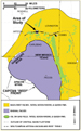
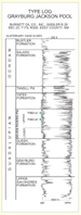
Grayburg Jackson Pool (study area) is one of several similar fields overlying the crest of the Wolfcampian Artesia-Vacuum Abo reef trend. Figure 1.1 is a map showing Upper Guadalupian (Queen-Seven Rivers-Yates) production and depositional facies of west Texas and southeastern New Mexico. The axis of Artesia-Vacuum Abo reef trend, which lies north of the Seven Rivers evaporite-carbonate transition, extends through the study area (Figure 1.2) (Sheldon, 1954). Lithostratigraphic nomenclature for Grayburg Jackson Pool and log features of the interval containing the reservoirs are shown on the type log in Figure 1.3.
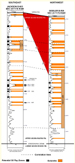
Well Log and Core Correlation (Figure 2.1)
“Potential oil pay zones” are based on log and core characteristics (i.e,. neutron log porosity > 10%; core fluorescence). Present gas/oil contact elevation is approximately 1830 feet above sea level. Figure 2.1 shows the correlation between the two wells from which cores were examined as a part of this study.
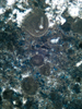
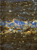
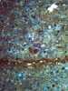
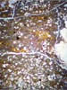
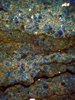
Petrography (Figures 2.2-2.16)Various facies types in the upper Seven Rivers Formation are described with the photomicrographs shown in Figures 2.2-2.16. They range from grainstone to boundstone. The carbonate units have been dolomitized. Grainstones are illustrated in Figures 2.4, 2.10, 2.12, and 2.15, and packstone is shown in Figures 2.2, 2.5, 2.6, 2.7, 2.8, 2.9, 2.16. Boundstone is represented by Figures 2.3, 2.11, and 2.13. Mudstone and anhydrite and shale are illustrated in Figures 2.10, 2.13, and 2.14.
Core Porosity and Permeability (Figure 3.1)
The boundstone is characterized by low permeability even though the porosity, in some cases, may be as much as 12-14% (Figure 3.1). The grainstones/packstones have higher permeability, and in general they show a correlation between porosity and permeability. Due to low permeability, “pay” porosity threshold is approximately 10%.
Depositional Environments (Figures 3.2-3.3)
SettingThe predominance of thick units of massive to nodular chicken-wire anhydrite interbedded with algally laminated carbonates indicates that evaporative, supratidal, coastal sabkha conditions dominated this area (Figure 3.2). Thin, porous tidal-channel carbonate units represent intermittent episodes of higher stands of base level, such that intertidal depositional conditions shifted temporarily landward.
Implications from Porosity Volume MapThe shaded area in Figure 3.3 is maximum pore volume (phi x ft >3). Although this figure is a “net pore volume” map for the entire upper Seven Rivers, it illustrates distinct shore-perpendicular (northwest-oriented) linear trends interpreted to be indicative of tidal channels. This would suggest that the depositional environment for porous units was probably intertidal.
Conclusions1) Upper Seven Rivers Formation carbonates span a range of depositional environments from tidal channels to intertidal algal mats. The evaporites are interpreted to be supratidal sabkha deposits. 2) The pinchout of dolomite units into sabkha sulfate evaporites, combined with drape over the underlying Artesia-Vacuum Abo reef, provided excellent stratigraphic and structural conditions for trapping petroleum. 3) Shoreline-perpendicular packstone/grainstone tidal channel facies were extensively dolomitized, creating secondary porosity that may have been preserved by early oil migration or by later dissolution of gypsum/anhydrite. 4) Although porosity is potentially as high as 30% in the tidal-channel facies, permeabilities are relatively low and the thin porous units are preferentially oriented, making the Seven Rivers a challenging reservoir for effective secondary recovery.
AcknowledgmentsWe wish to thank Burnett Oil Co. Inc., Fort Worth, Texas, for providing the cores and thin sections studied.
ReferencesBrister, B. S., and Ulmer-Scholle, D., 2000, Interpretation of depositional environments of upper Seven Rivers Formation from core and well logs, Grayburg Jackson Pool, Eddy County, New Mexico in West Texas Geological Society Publication #00-109, p. 65-72. Esteban, M., and L.C. Pray, 1983, Pisoids and pisolite facies (Permian), Guadalupe Mountains, New Mexico and West Texas, in Coated grains: Springer-Verlag, p. 503-537. Sheldon, V.P., 1954, Oil production from the Guadalupe Series in Eddy County, New Mexico, in New Mexico Geological Society: Guidebook, 5th Field Conference, p. 150-159. Ward, Robert F., Christopher G. St. C. Kendall, and Paul M. Harris, 1986, Upper Permian (Guadalupian) Facies and Their Association with Hydrocarbons--Permian Basin, West Texas and New Mexico: AAPG Bulletin, v. 70, p. 239-262. |