![]() Click to view article in PDF format.
Click to view article in PDF format.
Comprehensive Use of VSP Technology at Elk Hills Field, Kern County, California*
By
R.J. Brewer1 and Don Greenfield2
Search and Discovery Article #40091 (2003)
*The viewer is referred to two other articles about VSP, written by the senior author, The Look Ahead VSP Survey: Its Utility and Future, Search and Discovery Article #40060 (2002) and VSP Data in Comparison to the Check Shot Velocity Survey, Search and Discovery Article #40059 (2002).
1Halliburton Energy Services, Houston, TX ([email protected]).
2Occidental of Elk Hills, Inc.
Introduction
To understand accurately subsurface rock
formation and pay zone seismic travel times and velocities within the historic
Elk Hills oil field in Kern County, San Joaquin Valley, California (Figure 1),
Occidental of Elk Hills, Inc. in 1999 embarked on one of the first coordinated
and comprehensive VSP survey data ![]() acquisition
acquisition![]() programs in the country. The
trend-setting effort, uncommon in the United States, has helped produce more
accurate surface seismic time-to-drill depth conversions. This result has been
more accurate drilling prospect maps. VSP data has proven to be an effective
means to lower drilling ambiguities as well as overall drilling costs in the Elk
Hills field. It was concluded that rigorous integration of the all the VSP data
recorded during the campaign into a entire surface and borehole seismic data set
significantly improved the accuracy of a complex subsurface structural mapping
process. Knowledge of the challenging stratigraphy of the area has also been
enhanced. The result has been markedly improved success rates for exploration
and development well drilling.
programs in the country. The
trend-setting effort, uncommon in the United States, has helped produce more
accurate surface seismic time-to-drill depth conversions. This result has been
more accurate drilling prospect maps. VSP data has proven to be an effective
means to lower drilling ambiguities as well as overall drilling costs in the Elk
Hills field. It was concluded that rigorous integration of the all the VSP data
recorded during the campaign into a entire surface and borehole seismic data set
significantly improved the accuracy of a complex subsurface structural mapping
process. Knowledge of the challenging stratigraphy of the area has also been
enhanced. The result has been markedly improved success rates for exploration
and development well drilling.
Occidental purchased the Elk Hills field from
the United States government in late 1998. As part of a comprehensive plan to
assist development drilling and to prepare for exploration drilling, Oxy
acquired an 80 square mile seismic survey and completed preliminary mapping
throughout the Elk Hills field. Previous 2D and limited ![]() 3D
3D![]() seismic
seismic ![]() acquisition
acquisition![]() had proved problematic at best, yielding poor data. Near surface low velocity
air sands and extreme topographic variability (Figure
2) hampered surface
seismic data quality. Careful pre-3D
had proved problematic at best, yielding poor data. Near surface low velocity
air sands and extreme topographic variability (Figure
2) hampered surface
seismic data quality. Careful pre-3D ![]() acquisition
acquisition![]() testing and extensive quality
control yielded a
testing and extensive quality
control yielded a ![]() 3D
3D![]() seismic volume that was magnitudes better than any previous
seismic volume that was magnitudes better than any previous
![]() acquisition
acquisition![]() efforts (Figures 3 and
4).
efforts (Figures 3 and
4).
It has long been
known that VSP data has the established advantage of being generally higher
frequency and better quality than surface seismic. The VSP’s one-way travel path
from energy source to receiver helps prevent dissipation of frequency and
amplitude. Consequently, following the ![]() 3D
3D![]() seismic
seismic ![]() acquisition
acquisition![]() , a comprehensive
wellbore velocity data
, a comprehensive
wellbore velocity data ![]() acquisition
acquisition![]() program was initiated. Although there were
nearly 5,000 wells within the Elk Hills field, prior to the checkshot/VSP
program was initiated. Although there were
nearly 5,000 wells within the Elk Hills field, prior to the checkshot/VSP
![]() acquisition
acquisition![]() program, there were only 11 checkshots within the Elk Hills Field
and another 6 checkshots surrounding the field (Figure 5). During the 1980's,
one or two VSPs had been acquired. However, no digital VSP records were extant;
and only checkshot data remained.
program, there were only 11 checkshots within the Elk Hills Field
and another 6 checkshots surrounding the field (Figure 5). During the 1980's,
one or two VSPs had been acquired. However, no digital VSP records were extant;
and only checkshot data remained.
|
|
Click to
view sequence of Figures 5 and 6 for comparison of velocity data prior
and after
The
original Zero offset
VSP While zero offset VSPs were the goal, many times vibrators had to be offset in order to suppress noise attributable to ground roll and "ringing" pipe. Every effort was made to keep offsets less than 500 feet. However, due to excessive noise and topographic problems, one VSP was acquired with a 1,000-foot offset. Although this offset was considered excessive, the survey was acquired to test the viability of the data. The resultant data were excellent. Whenever
possible, 50-foot level intervals were acquired with a dual station
downhole geophone tool assembly from TD to near surface. These 50-foot
intervals were chosen after careful modeling indicated that this spacing
would be sufficient to correlate with In-field
data processing, to produce a corridor stack from the field records, was
employed on virtually every survey to give quick-look verification of
data quality at the wellsite and to expedite overall data integration
and interpretation. On numerous wells, the in-field corridor stacks and
At the
beginning, postulated expenditures for the aggressive
A
significant part of the exploration and development methodology employed
by Oxy involves being able to produce accurate time-depth functions at
any X-Y location encompassed by the surface seismic
Utilizing a
cost effective and aggressive velocity Some
practitioners have reportedly recommended that ideally one VSP survey be
acquired for each 1-2 square miles of |
 Figure 2:
Digital terrain model showing extreme topographic variations. Yellow and
red denotes higher elevations and blue lower elevations.
Figure 2:
Digital terrain model showing extreme topographic variations. Yellow and
red denotes higher elevations and blue lower elevations. Figure 3:
Elk Hills Oil Field highlighting the locations of major structural
features, well control, and comparative seismic data.
Figure 3:
Elk Hills Oil Field highlighting the locations of major structural
features, well control, and comparative seismic data. Figure 4:
Comparison of high effort, high quality 2D seismic data versus the high
effort
Figure 4:
Comparison of high effort, high quality 2D seismic data versus the high
effort  Figure 5:
Velocity data prior to VSP/Checkshot
Figure 5:
Velocity data prior to VSP/Checkshot  Figure
6: Velocity data after
Figure
6: Velocity data after  Figure 7:
VSP/3D seismic data correlation. VSP data was convolved with an
extracted wavelet from the
Figure 7:
VSP/3D seismic data correlation. VSP data was convolved with an
extracted wavelet from the  Figure 8:
Elk Hills south flank location, 351-17G.
Figure 8:
Elk Hills south flank location, 351-17G. Figure 9:
Seismic backdrop cross section through the 351-17G well.
Figure 9:
Seismic backdrop cross section through the 351-17G well. Figure 10:
Comparison of pre-drill velocity function (KNRVP generated from
substantial checkshot/VSP data) with actual velocity function from VSP
data shot in 351-17G well.
Figure 10:
Comparison of pre-drill velocity function (KNRVP generated from
substantial checkshot/VSP data) with actual velocity function from VSP
data shot in 351-17G well.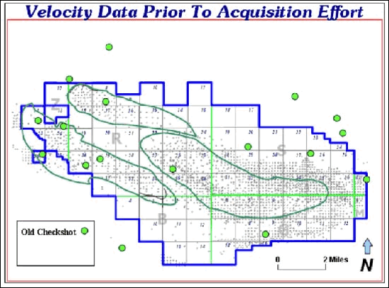