![]() Click to view page images in PDF format.
Click to view page images in PDF format.
Tectonostratigraphic Framework of the Columbus Basin, Eastern Offshore Trinidad*
L. J. Wood
Article #10014 (2001)
*Adapted for online presentation from article, entitled “Chronostratigraphy and Tectonostratigraphy of the Columbus Basin, Eastern Offshore Trinidad," by the author in AAPG Bulletin, v. 84, no. 12 (December, 2000), p. 1905-1928.
1Bureau of Economic Geology, University of Texas at Austin, Austin, Texas 78713-8924; email: [email protected]
The Columbus Basin, forming the easternmost part of the Eastern Venezuela Basin, is situated along the obliquely converging margins of the Caribbean and South American plates. The two primary structural elements that characterize the basin are (1) transpressional northeast-southwest-trending anticlines and (2) northwest-southeast-oriented, down-to-the-northeast, extension normal faults. The basin was filled throughout the Pliocene and Pleistocene by more than 40,000 ft (>12,200 m) of clastic sediment supplied primarily by the Paleo-Orinoco Delta system. The delta prograded eastward over a storm-influenced and current-influenced shelf during the Pliocene-Pleistocene, depositing marine and terrestrial clastic megasequences as a series of prograding wedges atop a lower Pliocene to pre-Pliocene mobile shale facies.
Biostratigraphic and well log data from 41 wells were integrated with
thousands of kilometers of interpreted two-dimensional and three-dimensional
seismic data to construct a chronostratigraphic framework for the basin. As a
result, several observations were made regarding the basin's geology that have a
bearing on exploration risk and success: (1) megasequences wedge bidirectionally;
(2) consideration of ![]() hydrocarbon
hydrocarbon![]() -system risk across any area requires looking at
these sequences as complete paleofeatures; (3) reservoir location is influenced
by structural elements in the basin; (4) the lower limit of a good-quality
reservoir in any megasequence deepens the closer it comes to the normal fault
bounding the wedge in a proximal location; (5) reservoir quality of deep-marine
strata is strongly influenced by both the type of shelf system developed (bypass
or aggradational) and the location of both subaerial and submarine highs; and
(6) submarine surfaces of erosion partition the megasequences and influence
hydrostatic pressure, migration, and trapping of hydrocarbons and the
distribution of
-system risk across any area requires looking at
these sequences as complete paleofeatures; (3) reservoir location is influenced
by structural elements in the basin; (4) the lower limit of a good-quality
reservoir in any megasequence deepens the closer it comes to the normal fault
bounding the wedge in a proximal location; (5) reservoir quality of deep-marine
strata is strongly influenced by both the type of shelf system developed (bypass
or aggradational) and the location of both subaerial and submarine highs; and
(6) submarine surfaces of erosion partition the megasequences and influence
hydrostatic pressure, migration, and trapping of hydrocarbons and the
distribution of ![]() hydrocarbon
hydrocarbon![]() type.
type.
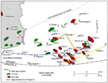
 Figure
1. Tectonic map (after Pocknall et al., 1999) showing regional structural
features of northern South America, including the island of Trinidad, as well as
the modern outlet of the Orinoco River and location of the present-day delta
relative to the Columbus Basin. Soldado 189 well is indicated in the Gulf of
Paria.
Figure
1. Tectonic map (after Pocknall et al., 1999) showing regional structural
features of northern South America, including the island of Trinidad, as well as
the modern outlet of the Orinoco River and location of the present-day delta
relative to the Columbus Basin. Soldado 189 well is indicated in the Gulf of
Paria.
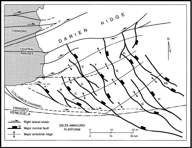
 Figure
2. Major structural features of the Columbus Basin, offshore eastern
Trinidad, including regional normal faults, right lateral strike-slip faults,
and offshore structural ridge trends.
Figure
2. Major structural features of the Columbus Basin, offshore eastern
Trinidad, including regional normal faults, right lateral strike-slip faults,
and offshore structural ridge trends.
Click here for sequence and overlay of Figures 2 and 4.
 Figure
3. Simplified stratigraphic chart of the Eastern Venezuela Basin (after
Heppard et al., 1998). Major source rock intervals have been identified as the
Upper Cretaceous San Antonio and Querecual formations in eastern Venezuela and
the Naparima Hill and Gautier formations in Trinidad. Units that have been
important reservoirs are also indicated. The dotted line indicates the
diachronous nature of top overpressure as it climbs stratigraphically to the
Figure
3. Simplified stratigraphic chart of the Eastern Venezuela Basin (after
Heppard et al., 1998). Major source rock intervals have been identified as the
Upper Cretaceous San Antonio and Querecual formations in eastern Venezuela and
the Naparima Hill and Gautier formations in Trinidad. Units that have been
important reservoirs are also indicated. The dotted line indicates the
diachronous nature of top overpressure as it climbs stratigraphically to the
![]() east
east![]() .
.
 Figure
4. Columbus Basin and the island of Trinidad showing wells used in this
study and location of major oil and gas fields. Cross section AA' and seismic
line XX' are shown in Figures 7 and 5,
respectively. Outcrop photographs are
shown in Figures 9a and 9b.
Figure
4. Columbus Basin and the island of Trinidad showing wells used in this
study and location of major oil and gas fields. Cross section AA' and seismic
line XX' are shown in Figures 7 and 5,
respectively. Outcrop photographs are
shown in Figures 9a and 9b.
Click here for sequence and overlay of Figures 2 and 4.
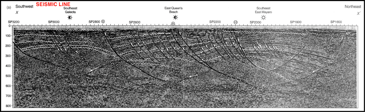
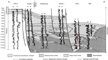
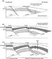
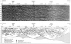 Figure
5. (a) Southwest-northeast-trending seismic line XX' (see Figure 4
for
location) and (b) accompanying line drawing illustrating the two-dimensional
geometry of normal fault and counterregional glide surface and their
relationship to one another. Regionally extensive lowstand surfaces
(unconformities) and their basinward-equivalent correlative conformities that
bound megasequences are shown. Note the thickening of sediments down into the
counterregional surface and the upturned toe reflectors associated with sediment
drag as shale evacuates from beneath the sediment wedge (SP1800-1600 between 3.0
and 5.0 s). Sediment wedges thin landward (southwest) and show truncation of
their upper parts by means of the lowstand surface of the overlying sequence.
Significant thickening of sediments occurs across major normal faults (SP2100,
SP2740). Although similar seismic facies are identifiable in different fault
blocks at approximately the same seismic depth, they are of different ages, as
shown by biostratigraphic data (see Figure 10).
Figure
5. (a) Southwest-northeast-trending seismic line XX' (see Figure 4
for
location) and (b) accompanying line drawing illustrating the two-dimensional
geometry of normal fault and counterregional glide surface and their
relationship to one another. Regionally extensive lowstand surfaces
(unconformities) and their basinward-equivalent correlative conformities that
bound megasequences are shown. Note the thickening of sediments down into the
counterregional surface and the upturned toe reflectors associated with sediment
drag as shale evacuates from beneath the sediment wedge (SP1800-1600 between 3.0
and 5.0 s). Sediment wedges thin landward (southwest) and show truncation of
their upper parts by means of the lowstand surface of the overlying sequence.
Significant thickening of sediments occurs across major normal faults (SP2100,
SP2740). Although similar seismic facies are identifiable in different fault
blocks at approximately the same seismic depth, they are of different ages, as
shown by biostratigraphic data (see Figure 10).
Click here for sequence and overlay of seismic line and line drawing.
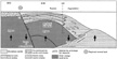
 Figure
6. Paleogeography of the lowstand paleo-Orinoco Delta in the Pliocene and
Pleistocene. Low-sloping broad fluvial distributary plain feeds line-source,
wave-modified strand-plain shoreline systems. These systems in turn feed
line-sourced slope and fan deposits. Rising shale diapirs at the toe of the
slope helped focus slope and basin floor deposition and ponded thick sediments
on the basin floor in toe-of-slope sediment sinks.
Figure
6. Paleogeography of the lowstand paleo-Orinoco Delta in the Pliocene and
Pleistocene. Low-sloping broad fluvial distributary plain feeds line-source,
wave-modified strand-plain shoreline systems. These systems in turn feed
line-sourced slope and fan deposits. Rising shale diapirs at the toe of the
slope helped focus slope and basin floor deposition and ponded thick sediments
on the basin floor in toe-of-slope sediment sinks.
 Figure
7. Southwest-northeast well log cross section AA' from Poui field to
Figure
7. Southwest-northeast well log cross section AA' from Poui field to ![]() East
East![]() Mayaro field across the Columbus Basin, illustrating the typical gamma-log
(left) and resistivity-log (right) signatures associated with depositional
facies that make up the prograding megasequences. Note the abrupt stratigraphic
thickening across the major normal growth faults in the depositional dip
direction (OPR4-Omega and Flambouyant-NEQB-EM3-EM1), as well as the continuity
of facies in the depositional strike direction (Omega-Flambouyant). Logs and
base Pleistocene pick in OPR4 and Flambouyant are from Heppard et al. (1998).
Environments of deposition are based on interpretation of integrated
biostratigraphic data, well log motifs, seismic facies, and regional
paleogeography. Line of section shown in Figure 4.
Mayaro field across the Columbus Basin, illustrating the typical gamma-log
(left) and resistivity-log (right) signatures associated with depositional
facies that make up the prograding megasequences. Note the abrupt stratigraphic
thickening across the major normal growth faults in the depositional dip
direction (OPR4-Omega and Flambouyant-NEQB-EM3-EM1), as well as the continuity
of facies in the depositional strike direction (Omega-Flambouyant). Logs and
base Pleistocene pick in OPR4 and Flambouyant are from Heppard et al. (1998).
Environments of deposition are based on interpretation of integrated
biostratigraphic data, well log motifs, seismic facies, and regional
paleogeography. Line of section shown in Figure 4.
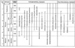 Figure
8. Biostratigraphic ranges defined by Pocknall et al. (1999) and derived in
conjunction with this study to differentiate chronostratigraphy of the Columbus
Basin.
Figure
8. Biostratigraphic ranges defined by Pocknall et al. (1999) and derived in
conjunction with this study to differentiate chronostratigraphy of the Columbus
Basin.
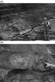 Figure
9. Photographs of Pliocene shelf-deltaic deposits of Gros Morne Formation of
the Columbus Basin outcropping along the southeast coast of Trinidad show
soft-sediment deformation, including (a) large channel scour truncating
underlying fine-grained sandstone, siltstone, and claystones deposited in a
shelf deltaic setting. The channel scours into structurally tilted sediments.
Its irregular base is filled with large rectangular blocks, which were
semicohesive when deposited and are composed of the substrate material. The
remainder of the channel is filled with alternating wavy-bedded silty sands and
shales. (b) Flame structure, characteristic of these rapidly deposited
sediments. Location of photos shown in Figure 4.
Figure
9. Photographs of Pliocene shelf-deltaic deposits of Gros Morne Formation of
the Columbus Basin outcropping along the southeast coast of Trinidad show
soft-sediment deformation, including (a) large channel scour truncating
underlying fine-grained sandstone, siltstone, and claystones deposited in a
shelf deltaic setting. The channel scours into structurally tilted sediments.
Its irregular base is filled with large rectangular blocks, which were
semicohesive when deposited and are composed of the substrate material. The
remainder of the channel is filled with alternating wavy-bedded silty sands and
shales. (b) Flame structure, characteristic of these rapidly deposited
sediments. Location of photos shown in Figure 4.
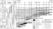 Figure
10. Chronostratigraphic chart of the Columbus Basin, showing progradational
character of the basin fill throughout the Pliocene and Pleistocene. Regional
subsidence in the southwest parts of the basin resulted in continuous
aggradation of mixed fluvial and estuarine deposits over much of the area.
Unconformities exhibit the greatest amounts of missing time in locations central
to the structural hinge of each megasequence. Foraminiferal and palynological
ranges are from Pocknall et al. (1999).
Figure
10. Chronostratigraphic chart of the Columbus Basin, showing progradational
character of the basin fill throughout the Pliocene and Pleistocene. Regional
subsidence in the southwest parts of the basin resulted in continuous
aggradation of mixed fluvial and estuarine deposits over much of the area.
Unconformities exhibit the greatest amounts of missing time in locations central
to the structural hinge of each megasequence. Foraminiferal and palynological
ranges are from Pocknall et al. (1999).
 Figure
11. Curves showing sea level change, fauna discontinuities, and sequence
boundaries for the world (columns 1, 2, 3) (Haq et al., 1988), the U.S.A.
margins of the Gulf of Mexico (columns 4, 5, 6), and the Columbus Basin,
Trinidad. Some sequence boundaries in the Columbus Basin appear correlative with
time-equivalent sea level falls and associated sequence boundaries identified in
other areas of the world. These sequence boundaries in the Columbus Basin are
most likely a function of eustatic base-level change (E); others appear to have
a more local tectonic origin (T). The tectonic nature of these boundaries is
supported by the presence in some wells of Cretaceous, Eocene, and Oligocene
fauna and flora identified as reworked in association with these boundaries (Pocknall
et al., 1999). Sources for the curves are (1) Beard et al. (1982); (2) Lamb et
al. (1987); (3) Haq et al. (1988); (4) Wornhardt and Vail (1990); (5) Pacht et
al. (1990); and (6) Armentrout and Clement (1990).
Figure
11. Curves showing sea level change, fauna discontinuities, and sequence
boundaries for the world (columns 1, 2, 3) (Haq et al., 1988), the U.S.A.
margins of the Gulf of Mexico (columns 4, 5, 6), and the Columbus Basin,
Trinidad. Some sequence boundaries in the Columbus Basin appear correlative with
time-equivalent sea level falls and associated sequence boundaries identified in
other areas of the world. These sequence boundaries in the Columbus Basin are
most likely a function of eustatic base-level change (E); others appear to have
a more local tectonic origin (T). The tectonic nature of these boundaries is
supported by the presence in some wells of Cretaceous, Eocene, and Oligocene
fauna and flora identified as reworked in association with these boundaries (Pocknall
et al., 1999). Sources for the curves are (1) Beard et al. (1982); (2) Lamb et
al. (1987); (3) Haq et al. (1988); (4) Wornhardt and Vail (1990); (5) Pacht et
al. (1990); and (6) Armentrout and Clement (1990).
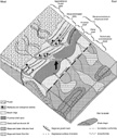
 Figure
12. Illustration of a single lower Pleistocene megasequence deposited across
the Southeast Galeota (SEG),
Figure
12. Illustration of a single lower Pleistocene megasequence deposited across
the Southeast Galeota (SEG), ![]() East
East![]() Queen's Beach (EQB), and
Queen's Beach (EQB), and ![]() East
East![]() Mayaro (EM)
areas between the JLS (T1) and the HLS (top surface). This sequence includes
many of the
Mayaro (EM)
areas between the JLS (T1) and the HLS (top surface). This sequence includes
many of the ![]() hydrocarbon
hydrocarbon![]() productive sands of
productive sands of ![]() East
East![]() Mayaro field and is bounded in
the proximal direction by the G fault (G) and in the distal direction by a lower
Pleistocene counterregional surface moving along a mobile shale body located
northeastward of the EM1 and EM2 wells (Figure 4).
Mayaro field and is bounded in
the proximal direction by the G fault (G) and in the distal direction by a lower
Pleistocene counterregional surface moving along a mobile shale body located
northeastward of the EM1 and EM2 wells (Figure 4).
 Figure
13. Illustration of the timing of formation (from oldest to youngest, a to b
to c, respectively) of various aspects of a typical megasequence across the gas
trend area from Cassia field (shown by the WSEG well [Figure
4]; southwest)
to
Figure
13. Illustration of the timing of formation (from oldest to youngest, a to b
to c, respectively) of various aspects of a typical megasequence across the gas
trend area from Cassia field (shown by the WSEG well [Figure
4]; southwest)
to ![]() East
East![]() Mayaro field (shown by the EM wells [Figure
4]; northeast). See text
for detailed discussion. CRG = counterregional guideplane.
Mayaro field (shown by the EM wells [Figure
4]; northeast). See text
for detailed discussion. CRG = counterregional guideplane.
Click here to view sequence of images in Figure 13.
 Figure
14. Illustration of the similarities and differences that exist between the
tectonostratigraphic characteristics of the Columbus Basin, Trinidad,
Figure
14. Illustration of the similarities and differences that exist between the
tectonostratigraphic characteristics of the Columbus Basin, Trinidad, ![]() model
model![]() (a)
and that of Evamy et al. (1978) Niger Delta, Nigeria,
(a)
and that of Evamy et al. (1978) Niger Delta, Nigeria, ![]() model
model![]() (b). Note the
bidirectional wedging of sediments, both distal toward the shale diapir and
proximal toward the normal fault, in the Columbus Basin, as compared with the
unidirectional wedging proximally that occurs in the Niger Delta.
(b). Note the
bidirectional wedging of sediments, both distal toward the shale diapir and
proximal toward the normal fault, in the Columbus Basin, as compared with the
unidirectional wedging proximally that occurs in the Niger Delta.
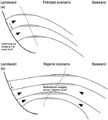 Figure
15. Illustration of the difference in alignment, deep to shallow, of
structural crests in some fields of (a) the Columbus Basin, Trinidad, vs. (b)
the Niger Delta, Nigeria (after Weber [1987]).
Figure
15. Illustration of the difference in alignment, deep to shallow, of
structural crests in some fields of (a) the Columbus Basin, Trinidad, vs. (b)
the Niger Delta, Nigeria (after Weber [1987]).
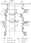 Figure
16. Electric log from the
Figure
16. Electric log from the ![]() East
East![]() Mayaro 3 well (see Figure 4
for location),
illustrating
Mayaro 3 well (see Figure 4
for location),
illustrating ![]() hydrocarbon
hydrocarbon![]() -bearing transgressive system tract (TST) waste-zones in
the 23 sand interval vs. the late-highstand systems tract (HST) to lowstand
systems tract (LST)
-bearing transgressive system tract (TST) waste-zones in
the 23 sand interval vs. the late-highstand systems tract (HST) to lowstand
systems tract (LST) ![]() hydrocarbon
hydrocarbon![]() accumulations in the higher quality 24 sand
interval.
accumulations in the higher quality 24 sand
interval.
General Geology of the Columbus Basin
Character of the Upper Tertiary Orinoco Delta
Faunal and Floral Biostratigraphy and Environments of Deposition
Depositional Environments and Facies
Rates of Sediment ![]() Accumulation
Accumulation![]()
Sequence Stratigraphy of the Columbus Basin
Influence of Tectonics on Stratigraphic Sequence Development
Tectonostratigraphic ![]() Model
Model![]()
Comparison with the Niger Delta
Structural Control on Depositional Systems and Accommodation Space
Implications and Recommendations for Exploration in the Columbus Basin
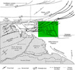
The Columbus Basin, defined by Leonard (1983), forms the easternmost part of
the Eastern Venezuela Basin (EVB) off the ![]() east
east![]() coast of Trinidad (Figure
1). The basin is bordered on the north by the Darien Ridge, an offshore
extension of Trinidad's Central Range, and on the south by the stable Delta
Amacuro Platform (Figure 2). To
the
coast of Trinidad (Figure
1). The basin is bordered on the north by the Darien Ridge, an offshore
extension of Trinidad's Central Range, and on the south by the stable Delta
Amacuro Platform (Figure 2). To
the ![]() east
east![]() of the basin is the South American continental shelf, and to the west,
onshore Trinidad and the EVB. Downwarping of the west margin of the EVB began
during the Oligocene in association with subduction of the Caribbean plate from
the north (Parnaud et al., 1995). A diachronous series of en echelon
of the basin is the South American continental shelf, and to the west,
onshore Trinidad and the EVB. Downwarping of the west margin of the EVB began
during the Oligocene in association with subduction of the Caribbean plate from
the north (Parnaud et al., 1995). A diachronous series of en echelon
![]() east
east![]() -northeast-oriented depocenters developed across the northern South America
region in response to this downwarping as the foredeep migrated eastward. The
depocenters were successively filled by more than 40,000 ft (>12,000 m) of
sediment, the Columbus Basin being the easternmost depocenter (Figure
1). The Orinoco River has been the primary source of sediment filling these
depocenters; since the mid-Miocene, its course has been heavily influenced by
the progressive downwarping of the eastward-migrating foreland basin (Hedberg,
1950; Hoorn et al., 1995; Diaz de Gamero, 1996). Local tectonic features, such
as the Urica arch (Figure 1), were
intermittently active during the Miocene to Holocene, significantly affecting
the character of the proto-Orinoco River feeding the Columbus Basin (Erlich and
Barrett, 1994). In addition, phases of thrusting and thrust-load subsidence
along the
-northeast-oriented depocenters developed across the northern South America
region in response to this downwarping as the foredeep migrated eastward. The
depocenters were successively filled by more than 40,000 ft (>12,000 m) of
sediment, the Columbus Basin being the easternmost depocenter (Figure
1). The Orinoco River has been the primary source of sediment filling these
depocenters; since the mid-Miocene, its course has been heavily influenced by
the progressive downwarping of the eastward-migrating foreland basin (Hedberg,
1950; Hoorn et al., 1995; Diaz de Gamero, 1996). Local tectonic features, such
as the Urica arch (Figure 1), were
intermittently active during the Miocene to Holocene, significantly affecting
the character of the proto-Orinoco River feeding the Columbus Basin (Erlich and
Barrett, 1994). In addition, phases of thrusting and thrust-load subsidence
along the ![]() east
east![]() margin of the northern Andes Cordillera influenced the discharge
rate and sediment load of the river throughout the late Tertiary (Hoorn et al.,
1995).
margin of the northern Andes Cordillera influenced the discharge
rate and sediment load of the river throughout the late Tertiary (Hoorn et al.,
1995).
The EVB is a prolific ![]() hydrocarbon
hydrocarbon![]() province, having produced more than 7
billion bbl of oil in the Venezuelan part of the basin (Erlich and Barrett,
1994) (Figure 1). Production has
come mainly from Oligocene to Miocene fluvial-deltaic and shallow-marine
deposits (Figure 3). Onshore and
offshore
province, having produced more than 7
billion bbl of oil in the Venezuelan part of the basin (Erlich and Barrett,
1994) (Figure 1). Production has
come mainly from Oligocene to Miocene fluvial-deltaic and shallow-marine
deposits (Figure 3). Onshore and
offshore ![]() hydrocarbon
hydrocarbon![]() exploration in Trinidad has been active since the 1860s,
and the first commercial production was established in 1902 (Tiratsoo, 1986).
Eastern offshore exploration for hydrocarbons in the Columbus Basin began in the
late 1960s, resulting in the discovery of Teak field (SDT2) (Figure
4). Subsequent activity has resulted in more than 2.6 billion bbl of oil
having been produced in these areas from fluvial-deltaic, shallow-marine, and
deep-marine turbidite deposits of the Miocene-Pliocene (Rodrigues, 1998).
Further estimates indicate more than 3.27 billion bbl of oil in place and 20 tcf
of gas in place.
exploration in Trinidad has been active since the 1860s,
and the first commercial production was established in 1902 (Tiratsoo, 1986).
Eastern offshore exploration for hydrocarbons in the Columbus Basin began in the
late 1960s, resulting in the discovery of Teak field (SDT2) (Figure
4). Subsequent activity has resulted in more than 2.6 billion bbl of oil
having been produced in these areas from fluvial-deltaic, shallow-marine, and
deep-marine turbidite deposits of the Miocene-Pliocene (Rodrigues, 1998).
Further estimates indicate more than 3.27 billion bbl of oil in place and 20 tcf
of gas in place.
The complex interplay of regional tectonics, extension normal faulting, high
rates of sediment supply, and sea level change has created a complicated
stratigraphy in the Columbus Basin, one that resists many standard methods of
sequence stratigraphic analysis. Classic sequence analysis techniques and models
that were developed in passive-margin settings (Vail et al., 1977; Posamentier
and Vail, 1988) typically operate on the assumption that sea level has been the
dominant mechanism driving stratigraphic sequence development. Application of
sequence stratigraphic models from foreland-basin (Swift et al., 1987; Devlin et
al., 1993; Posamentier and Allen, 1993) or passive-margin settings (Mitchum et
al., 1991) oversimplifies the complexity of transpressional settings.
Transpressional basins, such as the Columbus Basin, contain elements of thrust
belt-foreland models, the growth-normal faulting and mobile substrate movement
common to passive-margin settings, and extension structuring common along
strike-slip plate margins (Babb and Mann, 1999). Structural complexity,
syndepositionally active structures, high rates of sedimentation, and
high-frequency sea level change all influenced the Pliocene-Pleistocene sequence
stratigraphy of the Columbus Basin. The dearth of understanding of the relative
magnitude of influence these elements have on stratigraphic sequence geometry,
character, and distribution has led to mixed exploration and production results.
Understanding of the true age and nature of the basin's stratigraphic section
will decrease uncertainty in reservoir and seal prediction,
![]() hydrocarbon
hydrocarbon![]() -generation modeling, migration analysis, and pressure prediction, as
well as many other variables involved in an integrated exploration solution. As
petroleum exploration in the basin matures, there is a need for more detailed
understanding of the reservoir, seal geometry and distribution, and the timing
of all elements that make up the
-generation modeling, migration analysis, and pressure prediction, as
well as many other variables involved in an integrated exploration solution. As
petroleum exploration in the basin matures, there is a need for more detailed
understanding of the reservoir, seal geometry and distribution, and the timing
of all elements that make up the ![]() hydrocarbon
hydrocarbon![]() system. The syndepositional nature
of structure in the basin has created opportunities for the occurrence of
stratigraphic and combination stratigraphic/structure plays. However, these play
types cannot be pursued with any degree of confidence at the current level of
understanding stratigraphic sequence development in the Columbus Basin.
system. The syndepositional nature
of structure in the basin has created opportunities for the occurrence of
stratigraphic and combination stratigraphic/structure plays. However, these play
types cannot be pursued with any degree of confidence at the current level of
understanding stratigraphic sequence development in the Columbus Basin.
The goals of this article are to
- Detail a chronostratigraphic framework of the Columbus Basin;
- Outline a tectonostratigraphic
 model
model for sequence development in the Pliocene and Pleistocene of the
Columbus Basin, one that may serve to describe sequence stratigraphic
development in other transpressional settings;
for sequence development in the Pliocene and Pleistocene of the
Columbus Basin, one that may serve to describe sequence stratigraphic
development in other transpressional settings; - Compare and contrast the Columbus Basin with similar settings, such as the Niger Delta; and
- Discuss implications of the results of this work on exploration in the Columbus Basin and other transpressional settings.
A multidisciplinary data set, including well logs, palynology, benthic and planktonic foraminifera, oxygen isotopes, lithologic samples, core and outcrop descriptions, and seismic-line interpretations, was used to develop a chronostratigraphic and sequence stratigraphic framework for the Pliocene-Pleistocene deposits of the Columbus Basin. Data from 41 wells included paleontology assemblages and abundance and occurrence data, as well as gamma-ray, resistivity, and caliper logs. These data formed the ground truth for correlation of additional logs in the basin and were integrated with thousands of kilometers of interpreted two-dimensional (2-D) and three-dimensional (3-D) seismic lines to construct regional chronostratigraphic cross sections and to generate a chronostratigraphic framework for the Pliocene-Pleistocene of the basin.
The methodology employed in this study included the following:
- Reconciliation of multiple data types into an integrated depositional sequence analysis for each well in the study area. This required recognition of surfaces of reworking, flooding, and condensed sedimentation, as noted from well log motif and seismic data. In addition, casing points, sampling intervals, and drilling data were used to resolve in-situ from non-in-situ paleostratigraphic data and to refine environments of deposition. Key data for detailed interpretation of environments of deposition included benthic foraminifera and palynomorph assemblages, well log motifs, observable seismic facies, and location of specific wells within the context of the regional paleogeography.
- Use of palynomorph and planktonic foraminifera first uphole occurrence, extinction, and acme events in each well to age-date stratigraphic horizons.
- Use of seismic data to correlate specific time markers between wells within each fault block and to identify significant event surfaces within each fault block (bypass surfaces and basinward equivalent conformities, transgressive surfaces, condensed sections, flooding events, etc.).
- Definition of parasequences within each fault block, using identified key event surfaces and parasequence bounding surfaces.
- Reconciliation of the chronostratigraphic framework of each fault block with adjacent fault blocks by using seismic and well-data loops to ensure cross-fault correlation of time-equivalent depositional sequences and to construct regional chronostratigraphic cross sections.
- Correlation of chronostratigraphic packages between fault blocks, definition of basinwide depositional sequences, and construction of chronostratigraphic diagrams.
- Integration of
chronostratigraphy and paleogeography with seismic data to develop a
tectonostratigraphic model and to constrain the time of movement of major
structures in the basin.
General Geology of the Columbus Basin
The Columbus Basin is located along the south margin of the obliquely
converging Caribbean-South American plate boundary, a zone of intense structural
deformation (Figure 1) (Speed,
1985; Robertson and Burke, 1989). Primary structural elements in the basin
include (1) a series of transpressional northeast-southwest-trending ridges and
(2) northwest-southeast-oriented, down-to-the-northeast, normal faults (Figures
2, 5). Most reservoirs have
been discovered where compressional deep ridges are juxtaposed against major
normal growth faults to produce structural closure. Fold axial traces and normal
fault orientation, both less than 45~ to the plate boundary zone, indicate a
transpressional rather than a transcurrent or transtensional setting for the
Columbus Basin. Gravity tectonics along a thin-skinned detachment surface
dipping to the ![]() east
east![]() -northeast, however, may have also influenced the orientation
of these structural features, as well as masked the appearance of other
structures associated with these regimes, such as positive or negative flower
structure. The interpretation of a transpressional structural regime for this
area was well documented by Babb and Mann (1999), and the reader is referred to
this article for many data documenting the structural framework of the
Caribbean-South American margin in this area. Because a more detailed discussion
is beyond the scope of this article, the reader is additionally referred to
Perez and Aggarwal (1981), Robertson and Burke (1989), Erlich and Barrett
(1990), Ave Lallemant (1991), and Russo and Speed (1992).
-northeast, however, may have also influenced the orientation
of these structural features, as well as masked the appearance of other
structures associated with these regimes, such as positive or negative flower
structure. The interpretation of a transpressional structural regime for this
area was well documented by Babb and Mann (1999), and the reader is referred to
this article for many data documenting the structural framework of the
Caribbean-South American margin in this area. Because a more detailed discussion
is beyond the scope of this article, the reader is additionally referred to
Perez and Aggarwal (1981), Robertson and Burke (1989), Erlich and Barrett
(1990), Ave Lallemant (1991), and Russo and Speed (1992).
The sedimentary column of the eastern Columbus Basin consists mainly of thick
Pleistocene and Pliocene strata overlying mobile, pre-Pliocene shales.
Cretaceous marine facies deposited along a generally west-trending to
![]() east
east![]() -trending paleo-Cretaceous shelf break dip deep northward into the
subsurface and underlie the Tertiary sediments (Persad et al., 1993; Pindell and
Erikson, 1993; Heppard et al., 1998) (Figure
5). Although they remain undrilled in the Columbus Basin, the mobile units
of pre-Pliocene age are thought to consist dominantly of Miocene shales and
perhaps a thin veneer of Paleocene, Eocene, and Oligocene deposits. This
interpretation is supported by penetrations of pre-Pliocene units to the north
(Robertson and Burke, 1989) and south (Di Croce et al., 1999) of the basin, as
well as onshore Trinidad (Persad et al., 1993).
-trending paleo-Cretaceous shelf break dip deep northward into the
subsurface and underlie the Tertiary sediments (Persad et al., 1993; Pindell and
Erikson, 1993; Heppard et al., 1998) (Figure
5). Although they remain undrilled in the Columbus Basin, the mobile units
of pre-Pliocene age are thought to consist dominantly of Miocene shales and
perhaps a thin veneer of Paleocene, Eocene, and Oligocene deposits. This
interpretation is supported by penetrations of pre-Pliocene units to the north
(Robertson and Burke, 1989) and south (Di Croce et al., 1999) of the basin, as
well as onshore Trinidad (Persad et al., 1993).
Reservoirs off the ![]() east
east![]() coast of Trinidad are all Pliocene-Pleistocene in
age, either trapped in four-way structural closures or trapped as downthrown or
upthrown faulted three-way closures. The strata are marine and terrigenous
clastic sediments deposited as a series of northeastward-prograding
strand-plain/nearshore sediment wedges and downdip slope/basin fan wedges (Wood
et al., 1994; Wood, 1995, 1996; Heppard et al., 1998; Di Croce et al., 1999).
These extremely thick, prograding megasequences were rapidly deposited;
coast of Trinidad are all Pliocene-Pleistocene in
age, either trapped in four-way structural closures or trapped as downthrown or
upthrown faulted three-way closures. The strata are marine and terrigenous
clastic sediments deposited as a series of northeastward-prograding
strand-plain/nearshore sediment wedges and downdip slope/basin fan wedges (Wood
et al., 1994; Wood, 1995, 1996; Heppard et al., 1998; Di Croce et al., 1999).
These extremely thick, prograding megasequences were rapidly deposited;
![]() accumulation
accumulation![]() rates during the Pliocene-Pleistocene ranged from 7 to 20 ft (2 to
6 m) per thousand years. These high
rates during the Pliocene-Pleistocene ranged from 7 to 20 ft (2 to
6 m) per thousand years. These high ![]() accumulation
accumulation![]() rates resulted from high
sediment supply from the proto-Orinoco and rapid generation of accommodation
space by extension tectonics.
rates resulted from high
sediment supply from the proto-Orinoco and rapid generation of accommodation
space by extension tectonics.
Character of the Upper Tertiary Orinoco Delta
The modern Orinoco Delta is a complex hybrid deltaic system composed of distinctly defined zones of wave-dominated, tide-dominated, and river-dominated morphology (Warne et al., 1999a, b). The lower Tertiary Orinoco Delta differed in character, however, from its modern successor. The Orinoco Delta of the later Tertiary was a wave-dominated delta system prograding onto a storm-influenced and current-influenced shelf (Figures 6, 7). The delta occupied successively more eastward positions on the shelf throughout the late Tertiary, and upon reaching each successive shelf-edge break, the deltaic system became more aggradational in response to increased accommodation space. The shelf-to-slope break was oversteepened as a result of bed rotation along the counterregional glide surface formed on the landward side of rising shale diapirs. Such rotation is reflected in seismic data by the downdip thickening of sediments into the remnant shale bulge, as well as the drag exhibited at the toe of the progradational wedges (Figure 5). Most of the basin's accommodation was focused in northwest-southeast-oriented depocenters very near the shelf-slope break. Low accommodation on the shelf resulted in the paleo-Orinoco Delta repeatedly prograding to the edge of the shelf. This lowstand delta was exposed to the reworking processes of the open ocean, having little or no outboard shelf to attenuate wave activity. The cuspate, strike-continuous (northwest-to-southeast), cleanly winnowed reservoir sands of the Columbus Basin are a product of this setting. Modern analogs to this style of deltaic sedimentation are the Sao Francisco Delta, offshore Brazil (Dominguez, 1996), and the Nayarit Coast, offshore Mexico. Ancient examples include the lower Wilcox Formation of the Tertiary Gulf of Mexico (Galloway et al., 1982).
Few if any incised valleys that must have fed the lowstand Orinoco
Delta can be identified on 2-D or 3-D seismic lines. Paleoenvironmental data
from fauna and flora, however, indicate that brackish to terrestrial conditions
did exist across the basin during periods of lowstand delta deposition to the
![]() east
east![]() . Local tectonic activity at the depositional shelf break focused lowstand
accommodation space in shelf-break locations. High rates of sediment supply
filled all available proximal accommodation space, creating a broad, low,
sloping-gradient coastal plain. As a consequence, the Orinoco Delta distributary
system was most likely characterized by dispersed, low-velocity flows and low
stream powers that were forced to transport large volumes of sediment to
shelf-edge-break depocenters. Low slopes along the continental margin mean
little change in base level as sea level fell, resulting in the wide, shallow,
distributary-channel incision in the coastal plain. Truncation of older shelf
deposits by feeder valleys is shallow, commonly below the seismic resolution. In
some locations, such as the
. Local tectonic activity at the depositional shelf break focused lowstand
accommodation space in shelf-break locations. High rates of sediment supply
filled all available proximal accommodation space, creating a broad, low,
sloping-gradient coastal plain. As a consequence, the Orinoco Delta distributary
system was most likely characterized by dispersed, low-velocity flows and low
stream powers that were forced to transport large volumes of sediment to
shelf-edge-break depocenters. Low slopes along the continental margin mean
little change in base level as sea level fell, resulting in the wide, shallow,
distributary-channel incision in the coastal plain. Truncation of older shelf
deposits by feeder valleys is shallow, commonly below the seismic resolution. In
some locations, such as the ![]() East
East![]() Queen's Beach (EQB) area (Figure
4), late-stage pop-up structures may have confined distributaries to
specific pathways, resulting in point-source deltas, but for the most part late
Tertiary Orinoco deltas were line-source distributary systems producing
line-source slope deposits. Slope and basinal gravity deposits were, however,
subject to direction by submarine topography building out in front of the shelf
break.
Queen's Beach (EQB) area (Figure
4), late-stage pop-up structures may have confined distributaries to
specific pathways, resulting in point-source deltas, but for the most part late
Tertiary Orinoco deltas were line-source distributary systems producing
line-source slope deposits. Slope and basinal gravity deposits were, however,
subject to direction by submarine topography building out in front of the shelf
break.
Upper Cretaceous organic-rich mudstones acted as source rock for many of the hydrocarbons in Trinidad (Rodrigues, 1988; Talukdar et al., 1988; Heppard et al., 1990). Thicknesses of as much as 3280 ft (1000 m) of the Cretaceous source interval have been penetrated in the Soldado 189 well, Gulf of Paria (Figure 1). Cretaceous organic matter exhibits both terrigenous and marine organic affinities; total organic carbon (TOC) values range from 2 to 12% (Persad et al., 1993).
Previous workers have suggested two primary mechanisms for ![]() hydrocarbon
hydrocarbon![]() migration within the Columbus Basin. Strong evidence suggests that the large,
down-to-the-basin, normal faults serve as primary migration pathways for
hydrocarbons (Figure 5). Such
migration routes have been documented in the Columbus Basin, in the upper 2300
ft (700 m) of strata (Wood and Nash, 1995), and similar mechanisms are thought
to be active at depth (Leonard, 1983; Heppard et al., 1990, 1998). Faults in
Miocene strata in southern Trinidad appear to have acted as primary migration
conduits into Miocene and Pliocene reservoirs (Persad et al., 1993). All
offshore Trinidad fields are associated directly or indirectly with deep faults,
some of which are thought to extend into underlying Cretaceous source rocks
(Leonard, 1983). The occurrence of numerous
migration within the Columbus Basin. Strong evidence suggests that the large,
down-to-the-basin, normal faults serve as primary migration pathways for
hydrocarbons (Figure 5). Such
migration routes have been documented in the Columbus Basin, in the upper 2300
ft (700 m) of strata (Wood and Nash, 1995), and similar mechanisms are thought
to be active at depth (Leonard, 1983; Heppard et al., 1990, 1998). Faults in
Miocene strata in southern Trinidad appear to have acted as primary migration
conduits into Miocene and Pliocene reservoirs (Persad et al., 1993). All
offshore Trinidad fields are associated directly or indirectly with deep faults,
some of which are thought to extend into underlying Cretaceous source rocks
(Leonard, 1983). The occurrence of numerous ![]() hydrocarbon
hydrocarbon![]() seeps on the island
supports the notion that hydrocarbons are migrating directly along faults. Other
workers have suggested that most faulting in the fields postdates generation and
migration of hydrocarbons (Heppard et al., 1998). They have proposed an
alternative mechanism, namely, that hydraulically induced fractures within a
highly overpressured section are the conduit for migrating hydrocarbons (Miller,
1995; Heppard et al., 1998). A third possible migration pathway is via carrier
beds, which downlap onto or structurally abut onto the underlying source rocks
across glide planes (Figure 5) (Heppard
et al., 1998). In this scenario, updip migration is also aided by significant
overpressuring of fluids in the section. Most hydrocarbons in the Columbus Basin
probably migrate through some combination of these three mechanisms. The result
is a stair-step pattern of migration, whose tortuous nature helps explain the
fractionated and variable character of the hydrocarbons in Columbus Basin
reservoirs (Ross and Ames, 1988; Talukdar et al., 1990; Persad et al., 1993).
seeps on the island
supports the notion that hydrocarbons are migrating directly along faults. Other
workers have suggested that most faulting in the fields postdates generation and
migration of hydrocarbons (Heppard et al., 1998). They have proposed an
alternative mechanism, namely, that hydraulically induced fractures within a
highly overpressured section are the conduit for migrating hydrocarbons (Miller,
1995; Heppard et al., 1998). A third possible migration pathway is via carrier
beds, which downlap onto or structurally abut onto the underlying source rocks
across glide planes (Figure 5) (Heppard
et al., 1998). In this scenario, updip migration is also aided by significant
overpressuring of fluids in the section. Most hydrocarbons in the Columbus Basin
probably migrate through some combination of these three mechanisms. The result
is a stair-step pattern of migration, whose tortuous nature helps explain the
fractionated and variable character of the hydrocarbons in Columbus Basin
reservoirs (Ross and Ames, 1988; Talukdar et al., 1990; Persad et al., 1993).
Faunal and Floral Biostratigraphy and Environments of Deposition
Regional and local factors render more difficult the task of applying conventional biostratigraphy to define the Pliocene-Pleistocene chronostratigraphic framework in the Columbus Basin. The Orinoco and proto-Orinoco rivers have drained the Andean highlands since the early Miocene, but only since the late Miocene has the Orinoco had an established outlet through the Columbus Basin (Hoorn, 1995; Hoorn et al., 1995; Diaz de Gamero, 1996) (Figure 1). The river and its associated marginal and deep-marine depositional systems have supplied more than 45,000 ft (14 km) of post-Miocene sediment into the basin (Erlich and Barrett, 1990). This rapid rate of sedimentation has reduced the number of nannofossils and planktonic foraminifera species that are used in other basins for chronostratigraphic correlation. In addition, the overthick section creates time-resolution problems across the basin because age-range-limited fauna or flora are scarce relative to the thicknesses of strata. Thickening of stratal packages across regional growth faults creates the need for some form of time marker to aid in accurate correlation (Leonard, 1983). Those planktonic faunal markers that are present commonly suffer from suppressed extinction because of the high sedimentation rates, causing them to appear much shorter lived than their worldwide ranges. The high rates of sediment supply, high marine energy levels, and the incising nature of the riverine-sediment transport system within the basin also complicate faunal and floral correlations by reworking microfossils in many environments. This reworking not only confuses age relationships but also contaminates the in-situ environmental assemblages. Active thrusting on the island of Trinidad during the late Pliocene and the resulting high-relief terrain also obscure age relationships by providing reworked microfossils of all ages to the active depositional system. Finally, the rapid rates and high volumes of sediment being deposited in the basin have produced a very young and poorly consolidated section that is prone to downhole caving during drilling, resulting in spurious tops and bases (Pocknall et al., 1999). Data types must be integrated carefully to establish true ages and depositional environments of the sections of interest.
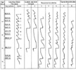
Faunal and floral extinctions and evolutions, as well as some abundance acme, derived from data in more than 41 wells (Figure 4) have been used in the Columbus Basin to aid in creating a chronostratigraphic framework for the Pliocene-Pleistocene. The age significance of planktonic foraminifera and palynomorph occurrences is detailed in Pocknall et al. (1996, 1999) (Figure 8).
Depositional Environments and Facies
In addition to the use of palynomorphs and planktonic foraminifera as age indicators, assemblage and abundance data of these fossils have been used, along with geophysical log motif, to define five distinct depositional facies that characterize the Columbus Basin: (1) fluvial/estuarine/transitional barrier island, (2) prograding shoreface, (3) slope fan, (4) basin-floor fan, and (5) condensed section facies. Details of the faunal and floral assemblages and their environments that characterize these elements are detailed in Pocknall et al. (1999) and are summarized in a following section.
Fluvial/Estuarine/Transitional Barrier
Fluvial/estuarine/transitional barrier depositional facies are composed of sediments deposited either subaerially or within the zone of tidal influence. Environments include active and abandoned channel fills, flood plains, swamps, estuarine sand bars, lagoons, beaches, marshes, and tidal flats. Mangrove pollen (derived from Rhizophora, Avicennia, and Pelliciera) is common in estuarine valley-fill sediments. Other significant components include the benthic foraminifera Milliammina telemaquensis, Arenoparrella mexicana, Ammonia beccarii, and Ammobaculities dilitatus; pollen derived from swamp plants such as Symphonia (Pachydermites diederixi) and Ceratopteris (Magnastriatities howardi); and Gramineae pollen derived from the swamp-marsh grass.
Log character for the fluvial and transitional barrier-complex facies consists of a blocky or occasional upward-fining motif commonly having a serrated texture. Sandier units are generally interbedded with alluvial overbank, fine-grained deposits and crevasse splay sands and fine-grained estuarine facies. In some wells, these finer grained intervals are several hundreds of feet thick. The sands that characterize these facies are well sorted and friable and in outcrop exhibit ripples, low-angle cross-beds, and some bidirectional cross-bedding. Interbedded dark-black, organic-rich siltstones and silty mudstones show ripples and wavy laminations. Reworked shells and plant and organic material are common. In outcrop, these facies exhibit soft sediment deformation. Little evidence of coal or lignite can be found in cutting samples from these facies, but in outcrop coals and laterally continuous lignites both are not uncommon.
Prograding Shoreface
Prograding shoreface consists of the lower, middle, and upper shoreface subfacies deposited predominantly below sea level and within the zone of wave, tide, and storm influence. Faunal assemblages reflect an overall upward-shallowing succession from Buliminella spp., Planulina foveolata, and Bolivina multicostata, to increasing occurrences of Uvigerina peregrina in the middle shelf, and, finally, Amphistegina lessonii, Nonionella atlantica, and Bolivina spinata in the inner shelf sediments. Finer grained shelfal units are characterized by abundances of dinoflagellates, whereas sandier shelf systems show a decrease in dinoflagellates. In outcrop these facies consist of thick, clean, fine-grained sands (10 to 20 ft [3 to 6 m]) separated by interbedded silts and clays. Isolated beds of coarse-grained to medium-grained sand can occur at the top of upward-coarsening sequences. Sorting varies from moderate to good as one moves distally in the shoreface system. Thicker sands, having sharp scoured bases, contain abundant large-scale and medium-scale trough cross-beds. Thick, fine-grained sandstone/siltstone intervals have abundant vertical burrowing and shell fragments. Ophiomorpha dominate the ichnofauna assemblage. Silt/sand intervals underlying coarser grained sands contain abundant evidence of dewatering structures and convoluted bedding. Log motifs of these facies are characterized by an upward-coarsening stack of progradational parasequences whose final top is commonly sharply truncated and whose thickness may range to almost 1000 ft (330 m).
Slope Fan
Slope-fan sediments are deposited as slope fans and slope-leveed channel complexes in depths ranging from 600 to 3000 ft (200 to 1000 m) of water. Assemblages characteristic of these facies include the consistent occurrence of Guppyella miocenica, Trochamina trincherasensis, Cyclammina cancellata, planktonic foraminifera, and the occasional presence of Haplophragmoides carinatum, H. narivaensis, Bathysiphon spp., and Reticulophragmium venezuelanum. Transported Rhizophora pollen is commonly seen in high numbers in these facies. These facies are poorly exposed in outcrop and core data are extremely limited. They are dominantly composed of gray, micaceous, highly calcareous silts and silty clays, rich in foraminifera, interbedded with fine-grained, laminated, micaceous sands containing some carbonaceous streaks. Sands are swaley bedded, having abundant bioturbation, and coarsen upward from very fine to fine. Shales show some soft sediment deformation, and siltstones show evidence of low-angle cross-bedding. Well logs in these deposits are characterized by ratty, sand-shale log character, which typically fines upward in packages as thick as 1000 ft (330 m).
Basin-Floor Fan
Basin-floor-fan facies are deposited in very deep water (>3000 ft [1000 m]) near the toe of the slope. They contain much reworked middle to outer neritic fauna mixed with in-situ, deeper water, agglutinated fauna. In-situ fauna include common to abundant planktonics; benthic forms include Recurvoides obsoletum, Cyclammina cancellata, Ammodiscus spp., and Alveovalvulina suteri. Flora present include abundances of dinoflagellates and land-derived Rhizophora and various species of fern spores. Basin-floor-fan facies have not been described in outcrop or core. Well log motif of these sediments is sharp to sharply gradational at the base, overlain by several stacked packages (each ~100 ft [~30 m] thick), which show a blocky to slightly serrated character.
Condensed Section
Deep-water, fine-grained silts and shales compose the condensed section facies. Consistent and abundant Glomospira charoides, Alveovalvulina suteri, and Reticulophragmium venezuelanum are found in these facies. Dinoflagellates are common and commonly consist of monospecific assemblages of Nematosphaeropsis lemniscata. Well logs indicate very low resistivities and high (hot) gamma signatures associated with these deposits. Although condensed sections have not been cored in the basin, they are thought, on the basis of log character, to consist dominantly of silts and clay.
Rates of Sediment ![]() Accumulation
Accumulation![]()
Sediment supply throughout the Pliocene and Pleistocene in the Columbus Basin
was enormous, having the bulk of these sediments derived from the Andes
Mountains and associated regions far to the southwest of Trinidad. Rates of
sediment ![]() accumulation
accumulation![]() in the basin during this time period surpassed those seen
in other Tertiary deltaic settings, such as the Mississippi, Niger, or Nile
deltas. Sediment
in the basin during this time period surpassed those seen
in other Tertiary deltaic settings, such as the Mississippi, Niger, or Nile
deltas. Sediment ![]() accumulation
accumulation![]() rates of as much as 15 to 20 ft (5 to 6 m) per
1000 yr are typical across the basin, having rates of as much as 26 ft (8 m) per
1000 yr in some depocenters (Figure 7).
Evidence of these rapid rates of
rates of as much as 15 to 20 ft (5 to 6 m) per
1000 yr are typical across the basin, having rates of as much as 26 ft (8 m) per
1000 yr in some depocenters (Figure 7).
Evidence of these rapid rates of ![]() accumulation
accumulation![]() can be seen in the sedimentary
structures that characterize the upper Tertiary clastic section. Outcrops of
Pliocene strata on the island of Trinidad exhibit dewatering structures, flame
structures of as much as 3 ft (1 m) in height, fluidized flow features, large
ball and pillow features, and large-scale convoluted bedding (Figures
9a, 9b). Deposits
characterized by such features are commonly mistaken for deeper marine,
mass-flow facies. However, careful examination of these deposits reveals
coinciding ripple cross-laminations, climbing ripples, large-scale trough
cross-beds, tidal bedding and in-situ shelfal ichnofauna (Skolithos),
some vertical burrows reaching as much as 5 ft (15 m) in length (Farrelly,
1987). All evidence supports an interpretation of a shallow-water, shelfal
setting for deposition of these units.
can be seen in the sedimentary
structures that characterize the upper Tertiary clastic section. Outcrops of
Pliocene strata on the island of Trinidad exhibit dewatering structures, flame
structures of as much as 3 ft (1 m) in height, fluidized flow features, large
ball and pillow features, and large-scale convoluted bedding (Figures
9a, 9b). Deposits
characterized by such features are commonly mistaken for deeper marine,
mass-flow facies. However, careful examination of these deposits reveals
coinciding ripple cross-laminations, climbing ripples, large-scale trough
cross-beds, tidal bedding and in-situ shelfal ichnofauna (Skolithos),
some vertical burrows reaching as much as 5 ft (15 m) in length (Farrelly,
1987). All evidence supports an interpretation of a shallow-water, shelfal
setting for deposition of these units.
Pliocene-Pleistocene sediments in the subsurface of the basin are virtually
unconsolidated. Sand porosities, even at burial depths exceeding 12,000 ft
(>3660 m), can have 25 to 35%; permeabilities of several hundreds of darcys
are not atypical. Overpressure problems exist throughout the basin and are
partly due to the rapidly deposited, stacked, shallow, clastic shelf deposits
overlying deeper outer-shelf and upper-slope facies (Heppard et al., 1998). All
of these characteristics are evidence of a depositional setting having extremely
rapid ![]() accumulation
accumulation![]() of sediment, occurring in a shallow-marine shelf setting.
of sediment, occurring in a shallow-marine shelf setting.
Sequence Stratigraphy of the Columbus Basin
A series of progradational clastic wedges form the Pliocene-Pleistocene
stratigraphic architectural package of the Columbus Basin (Figure
10). Development and character of these wedges are driven by three primary
elements, namely, tectonic activity, sediment supply, and marine-process
redistribution of sediments. Although they progress from oldest in the west to
youngest in the ![]() east
east![]() , the wedges exhibit many similar characteristics. Each
clastic wedge prograded from southwest to northeast across a part of the basin,
and each exhibits a high degree of lateral facies continuity along depositional
strike (northwest-southeast) (Figure 7).
Within each wedge, the depositional facies deepen progressively from southwest
to northeast, changing from (1) terrigenous fluvial/estuarine to (2)
progradational or aggradational shoreface to (3) middle and outer neritic shelf
to (4) slope and, finally, to (5) basinal facies over a distance of a few
kilometers. Distal parts of each prograding wedge downlap onto a mobile
substrate thought to be the top of thick Miocene marine shales (Figure
5). Megadepositional sequences (defined here as genetically related strata
bounded by regionally unconformable surfaces and their basinward correlative
conformities) average 10,000 to 12,000 ft (3000 to 3660 m) in thickness and
accumulated over relatively short periods (300,000 to 500,000 yr).
, the wedges exhibit many similar characteristics. Each
clastic wedge prograded from southwest to northeast across a part of the basin,
and each exhibits a high degree of lateral facies continuity along depositional
strike (northwest-southeast) (Figure 7).
Within each wedge, the depositional facies deepen progressively from southwest
to northeast, changing from (1) terrigenous fluvial/estuarine to (2)
progradational or aggradational shoreface to (3) middle and outer neritic shelf
to (4) slope and, finally, to (5) basinal facies over a distance of a few
kilometers. Distal parts of each prograding wedge downlap onto a mobile
substrate thought to be the top of thick Miocene marine shales (Figure
5). Megadepositional sequences (defined here as genetically related strata
bounded by regionally unconformable surfaces and their basinward correlative
conformities) average 10,000 to 12,000 ft (3000 to 3660 m) in thickness and
accumulated over relatively short periods (300,000 to 500,000 yr).
The megasequences are internally composed of five to eight progradational
parasequences, each averaging 550 to 980 ft (170 to 300 m) in thickness and
deposited over 50,000 to 100,000 yr (Figures
7, 10). These parasequences
contain reservoir sand bodies elongated along depositional strike. Facies within
each parasequence show a high degree of continuity in the depositional strike
direction but give way in a depositional dip direction (generally,
north-northeast) and within a few kilometers to deep-marine environments.
Parasequences are bounded by subregional regressive surfaces of erosion at their
bases and by subregional deepening events at their tops. These flooding events,
extensive along strike, result in ![]() accumulation
accumulation![]() of shales that make excellent
local seals, although these same shales are limited in the dip direction. They
therefore make poor correlation markers regionally (i.e., beyond the extent of a
single megasequence) and cannot be assumed to form high-quality seals across a
regional area.
of shales that make excellent
local seals, although these same shales are limited in the dip direction. They
therefore make poor correlation markers regionally (i.e., beyond the extent of a
single megasequence) and cannot be assumed to form high-quality seals across a
regional area.
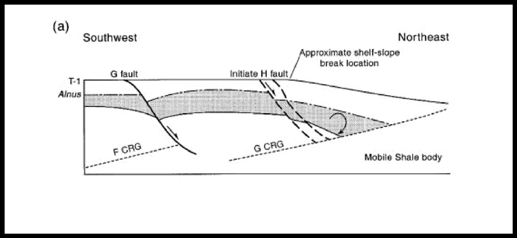
Several key surfaces have been identified that are important in defining the megasequences that fill the Columbus Basin. From youngest to oldest, the regionally extensive surfaces (see Figures 10, 11) are (1) the near base Pliocene lowstand surface (LS) (NBPLS; 3.8 m.y.), (2) the base green LS (BGLS; 3.6 m.y.), (3) the base 8 sand LS (B8LS; 3.0 m.y.), (4) the base braided 2 sand LS (BB2LS; 2.3-2.4 m.y.), (5) the "N" LS (NLS; 2.0 m.y.), (6) the "J" LS (JLS or base Alnus lowstand; 1.78 m.y.), (7) the "H" LS (HLS; 1.5 m.y.), (8) the "F" LS (FLS; 1.3 m.y.), (9) the "F" transgressive surface (FTS; 1.2 m.y.), (10) the "E" LS (ELS; 1.0 m.y.), (11) the "D" LS (DLS; 0.8 m.y.), and (12) the "B" LS (BLS; 0.5 m.y.). These surfaces, with the exception of the FTS, mark basinwide episodes of basinward facies shifts and the progressive northeastward progradation of the Orinoco Delta system. Each episode is characterized by a rapid thickening of the stratigraphic section across successively eastward growth faults. Stratigraphic architecture within these fault blocks typically consists of deep-water marine clastics grading upsection into successively shallower shelf deposits and finally culminating in the sudden deposition of a series of stacked shelf parasequences (Figures 5, 10). Each sequence is capped by an unconformity associated with sediment bypass of the next-younger sequence. The FTS is a regionally extensive surface of deepening that corresponds to mid-Pleistocene marine flooding and landward translation of facies across the basin. This event initiated a distinct change in the basin toward higher frequency and larger magnitude translations of shoreline. The result is a series of large-magnitude lowstand progradational and highstand retrogradational events occurring across the area during the mid to late Pleistocene, having thin, shallow, widespread lowstand systems tracts alternating with thick, deep-water, transgressive shales (Figures 7, 10). The apparent increase in number of Pleistocene sequences (six) relative to Pliocene sequences (three) is superficial and a function of an increased abundance of key faunal and floral extinctions and first occurrences in the Pleistocene and uppermost Pliocene sections. This fact allows for a more detailed resolution of regionally extensive surfaces in the younger sections.
A second level in the hierarchy of surfaces is the subregionally extensive surfaces that developed as a function of more localized, structurally driven variations in accommodation space. The most pronounced of these localized surfaces are several large-magnitude marine unconformities that are somewhat angular and appear to divide the stratigraphic sections in each megasequence into a lower and an upper stratigraphic interval (Figures 5, 7). The lower stratigraphic intervals, characterized by a few specific shallowing events, are dominated by deeper marine facies. In contrast, the upper intervals are dominated by shallow-marine to fluvial facies, which contain abundant and distinct parasequence-scale shoreface cycles. These diachronous marine unconformities postdate the preceding maximum flooding surface and early highstand systems tract deposits. These unconformities appear to be regressive surfaces of marine erosion, which precede the most dramatic and continuous phases of late highstand progradation and aggradation in the basin. These surfaces form as a result of submarine tide, wave, and storm processes active on the depositional shelf. Similar regressive surfaces of marine erosion have been identified in both ancient and modern deposits (Plint, 1988; Posamentier et al., 1992; Posamentier and Allen, 1993), albeit not having the pronounced expression seen in the Columbus Basin, which is likely a function of syndepositional tectonism. Large-scale flexuring in the basin created a structural hinge along which marine erosion was enhanced.
Influence of Tectonics on Stratigraphic Sequence Development
The Columbus Basin regional chronostratigraphic framework discussed on preceding pages has been used to explain the complex relationships between larger, regionally extensive normal faults, mobile shale diapirs, and the deposition of large, clastic-rich megasequences that make up the stratigraphic architecture of the Columbus Basin.
Regional extension, associated with the oblique transpression of the
Caribbean plate to the north and the South American plate to the south, creates
sites of weakness for prograding sediments to load, further enhancing failure
along normal faults. The initiation of movement on these extension faults is
reflected in the stratigraphy on their downthrown side. There the stratigraphic
units most proximal to the downthrown side of the fault are deep-marine deposits
overlain by an initial progradational shallow-marine sand, overlain by another
deep flooding event marking early activity on the normal fault. Once the
tectonic accommodation space closest to the fault is filled, the succession
progrades ![]() east
east![]() of the proximal normal fault, eventually stalling near the
depositional shelf break. These faults, once initiated, bound the proximal side
of a single megasequence (Figure 12).
Aided by loading from the weight of progressive sediment deposition, mobile
shales are forced northeastward and begin to rise. Accommodation space is
generated beneath the basinal edge of the megasequence by shale withdrawal, and
subsidence begins along a counterregional glide plane, creating distal
accommodation space. Growth occurs across the proximal bounding faults (G in Figure
12) as sediments from the proto-Orinoco strive to fill proximal
accommodation space. Stratigraphic thickening likewise occurs toward the diapir
in response to progressive downward rotation of beds along the counterregional
glide-plane surface (Figure 12).
of the proximal normal fault, eventually stalling near the
depositional shelf break. These faults, once initiated, bound the proximal side
of a single megasequence (Figure 12).
Aided by loading from the weight of progressive sediment deposition, mobile
shales are forced northeastward and begin to rise. Accommodation space is
generated beneath the basinal edge of the megasequence by shale withdrawal, and
subsidence begins along a counterregional glide plane, creating distal
accommodation space. Growth occurs across the proximal bounding faults (G in Figure
12) as sediments from the proto-Orinoco strive to fill proximal
accommodation space. Stratigraphic thickening likewise occurs toward the diapir
in response to progressive downward rotation of beds along the counterregional
glide-plane surface (Figure 12).
A typical sequence of fault initiation and strata development is illustrated
in Figure 13. Fault G, active
pre-time marker 1 (T1), shows growth and terminates glide plane F at depth. The
sediment wedge to the northeast of fault G begins to be rotated above
counterregional glide plane G, creating a shelf break and locus of sediment
![]() accumulation
accumulation![]() landward of the outlying shale diapir. Fault H is initiated in
response to continued extension and mobile-shale withdrawal. Sediment loading
proximal to the diapir and subregional subsidence enhance shale withdrawal,
severing the subsurface glide plane G. Subregional withdrawal subsidence within
fault block G-H ceases. Sediments fill remaining accommodation space in the area
and prograde the shelf break eastward of fault H. Fault G continues to show
limited activity and growth well into time 2 (T2), but the bulk of extension and
growth between T1 and T2 is taken up at fault H. Rotation occurs at depth above
the more eastward counterregional glide plane H, and both the shelf break and
loci of
landward of the outlying shale diapir. Fault H is initiated in
response to continued extension and mobile-shale withdrawal. Sediment loading
proximal to the diapir and subregional subsidence enhance shale withdrawal,
severing the subsurface glide plane G. Subregional withdrawal subsidence within
fault block G-H ceases. Sediments fill remaining accommodation space in the area
and prograde the shelf break eastward of fault H. Fault G continues to show
limited activity and growth well into time 2 (T2), but the bulk of extension and
growth between T1 and T2 is taken up at fault H. Rotation occurs at depth above
the more eastward counterregional glide plane H, and both the shelf break and
loci of ![]() accumulation
accumulation![]() reside
reside ![]() east
east![]() of fault H and proximal of glide plane H (Figure
13c). Expansion and growth continue along the H fault (T3), stratigraphic
thicknesses increasing by shale withdrawal and counterregional rotation. The H
fault eventually proves unable to keep pace with further extension because of
exhaustion of mobile material at depth. Any remaining accommodation space is
filled and there is a progressive eastward shift of extension faulting,
shelf-slope break location, and lateral shale withdrawal.
of fault H and proximal of glide plane H (Figure
13c). Expansion and growth continue along the H fault (T3), stratigraphic
thicknesses increasing by shale withdrawal and counterregional rotation. The H
fault eventually proves unable to keep pace with further extension because of
exhaustion of mobile material at depth. Any remaining accommodation space is
filled and there is a progressive eastward shift of extension faulting,
shelf-slope break location, and lateral shale withdrawal.
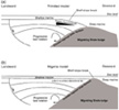
Comparison with the Niger Delta
The relationship between structure and stratigraphy in the geologic evolution
of the Columbus Basin resembles that identified by Evamy et al. (1978) in the
Niger Delta (Figure 14). In the
Niger Delta ![]() model
model![]() , shale migration establishes a bathymetric high in front of
the progradational Niger shelf system, forming a break between paralic/deltaic
sedimentation, which has been trapped behind the bulge and slope/bathyal
sedimentation outboard of the bulge crest. Beds deposited behind the bulge show
progressive downward rotation and steepening of dip along a counterregional
glide plane associated with progressively basinward migration of the mobile
shale. Large growth faults develop landward in response to extension and mobile
shale withdrawal at depth.
, shale migration establishes a bathymetric high in front of
the progradational Niger shelf system, forming a break between paralic/deltaic
sedimentation, which has been trapped behind the bulge and slope/bathyal
sedimentation outboard of the bulge crest. Beds deposited behind the bulge show
progressive downward rotation and steepening of dip along a counterregional
glide plane associated with progressively basinward migration of the mobile
shale. Large growth faults develop landward in response to extension and mobile
shale withdrawal at depth.
Although similarities between the offshore Nigeria tectonostratigraphic
processes and those of Trinidad's Columbus Basin are obvious, a few notable
differences exist. The most obvious of these differences is the location of the
shelf-slope break with respect to the migrating shale bulge. In the Niger Delta
![]() model
model![]() , the break between shelfal water depths and slope/bathyal water depths
occurs at the crest of the shale bulge (Figure
14). This configuration limits distribution of deep-marine facies to the
distal side of the bulge, having little primary depositional dip across the
sedimentary shelf system, proximal to the bulge. In contrast, the Orinoco Delta
strata exhibit a distinct break from shelf to slope/bathyal water depths on the
proximal side of the shale bulge. The result is a significant bathymetry change
across the sedimentary shelf and slope systems. Slope and basinal facies are
thus able to downlap and onlap the underlying mobile shales. This difference
creates significant primary depositional dip across the Columbus Basin
depositional system proximal to the shale bulge.
, the break between shelfal water depths and slope/bathyal water depths
occurs at the crest of the shale bulge (Figure
14). This configuration limits distribution of deep-marine facies to the
distal side of the bulge, having little primary depositional dip across the
sedimentary shelf system, proximal to the bulge. In contrast, the Orinoco Delta
strata exhibit a distinct break from shelf to slope/bathyal water depths on the
proximal side of the shale bulge. The result is a significant bathymetry change
across the sedimentary shelf and slope systems. Slope and basinal facies are
thus able to downlap and onlap the underlying mobile shales. This difference
creates significant primary depositional dip across the Columbus Basin
depositional system proximal to the shale bulge.
A second difference between these two models is the discrepancy in the height of the shale bulge (Figure 14). Although Evamy et al. (1978) suggested that the shale bulges in the Niger Delta rise to near sea level, the crests of the shale bulges in the Columbus Basin, Orinoco Delta, never rose to shelfal water depths. This interpretation, based on paleobathymetric data and seismic facies analysis of deposits that onlap the shale bulges, suggests outer neritic to bathyal water depths and facies associated with these deposits. Finally, shale bulges in the Columbus Basin were probably subjected to reworking by geostrophic currents, longshore currents, slumps, and slides that were more effective than similar features in the offshore Nigeria area. This inference is based partly on the high magnitude of offshore submarine forces reworking the Columbus Basin area throughout the late Tertiary and today, as well as the tectonic activity of the basin.
Niger Delta oil fields are characterized by structural crests that migrate
back into the fault in successively younger strata (Weber, 1987). This pattern
indicates syndepositional wedging back into bounding growth faults (Figure
15a). In the Columbus Basin, however, some of the structures, such as ![]() East
East![]() Mayaro field, have structural crests that migrate away from the normal fault in
successively younger strata. This pattern may reflect postdepositional
modification of the original locations of the structural crest by late growth
across the field-bounding normal fault. Figures
5 and 13 illustrate these
differences, showing post-Grimsdalea (FLS) depositional growth along the H fault
causing migration of the structural crests of T1 (HLS) horizons to successively
more eastward positions.
Mayaro field, have structural crests that migrate away from the normal fault in
successively younger strata. This pattern may reflect postdepositional
modification of the original locations of the structural crest by late growth
across the field-bounding normal fault. Figures
5 and 13 illustrate these
differences, showing post-Grimsdalea (FLS) depositional growth along the H fault
causing migration of the structural crests of T1 (HLS) horizons to successively
more eastward positions.
A final noted difference between the Trinidad and Nigeria sequences is that of bidirectional wedging of sediments within the Columbus Basin megasequences vs. unidirectional wedging of strata proximally in the Niger Delta (Weber, 1987). This difference is a function of the location of the depositional shelf break, which occurs proximal of the eastward-migrating shale diapir in the Columbus Basin system. Sediments thicken in response to distal accommodation along the associated counterregional surface, as well as thickening, similar to that in the Niger Delta setting, along the proximal normal fault.
Structural Control on Depositional Systems and Accommodation Space
Structural uplifts associated with Miocene and early Pliocene thrusting to the west of Trinidad contributed sediments to the basin and focused fluvial feeder systems into the basin (Speed, 1985). As this compressional deformation wave moved progressively southward and eastward, compressional ridges, oriented northeast-southwest were formed in the offshore areas of the Columbus Basin. Today these ridges form the productive offshore trends (Figure 4) and are as young as Pleistocene in age. Earlier formed ridges in the northwestern areas served to channel late Pleistocene distributaries along lows in the proximal coastal plain. Such focusing of fluvial feeder systems aided in transport of sediment across what was a very low, broad coastal plain.
Limited accommodation space in the coastal plain and most inner-shelf areas meant rapid progradation of depositional systems during the early stages of any sea level fall. In some cases, shorelines most likely moved basinward as a result of sediment outbuilding only to stall as they impinged upon high-accommodation zones at the shelf break, steepened by focused zones of shale withdrawal (see Figures 6, 12). Sediments from the proto-Orinoco Delta were most likely swept northeastward by strong longshore currents until abutting against the offshore bathymetric highs formed by eastern extension of the Darien Ridge. The linear (northwest-southeast) nature of shale bulge fronts led to northwest-southeast-oriented loci of deposition and subsequent lineation of strand-plain deposits.
Two types of parasequences make up these stacked shoreface parasequence sets:
(1) bypass and (2) aggradational shorefaces. Bypass-shoreface development
occurred in areas of limited accommodation space, either proximally along the
structural hinge of a megasequence or at the shelf break during times of low
subsidence. These systems exhibit a thin progradational base, indicating rapid
progradation and little ![]() accumulation
accumulation![]() of sediments. The parasequence overall is
of limited thickness, bypassing most sediment basinward early in lowstand time
to form slope and basin-floor fan systems.
of sediments. The parasequence overall is
of limited thickness, bypassing most sediment basinward early in lowstand time
to form slope and basin-floor fan systems.
In contrast, aggradational shoreface development occurred during times of high rates of accommodation-space development, typically at the depositional shelf break. These systems may possess either thin or thick progradational bases, depending on the availability of early highstand accommodation space. Where large amounts of lowstand sediments are stored in the aggrading lowstand shoreface, little sediment is left over to form gravity deposits on the slope and basin, resulting in limited development of slope fan and basin-floor fan reservoirs. This concept was illustrated in modeling studies by Ross (1990), and these relationships between deep-water and shallow-water deposition are documented in strata across the basin.
Because of the high sediment-supply rates of the Orinoco Delta system,
accommodation space is almost always completely filled during lowstand cycles.
The late lowstand fill leaves little space to accommodate transgressive systems
tract sediments. Biofacies associated with sediments, typically shales,
overlying lowstand shoreface deposits show rapid deepening above these systems.
This rapid deepening is reflected in the limited, to unresolvable, thickness of
many transgressive systems tracts and limited ability to resolve shelf onlap on
conventional seismic lines. Such onlap in other basins is commonly used as
evidence of transgression. In addition, these rapid flooding events create an
excellent reservoir/seal relationship (Figure
16). In a few locations within the basin, transgressive subsidence is
greater than sediment supply, and transgressive sediments back step above the
lowstand shoreface system. The resulting transgressive systems tract can form a
![]() hydrocarbon
hydrocarbon![]() "waste zone" that has limited productivity (Figure
16) as compared with highstand and early lowstand deposits.
"waste zone" that has limited productivity (Figure
16) as compared with highstand and early lowstand deposits.
Implications and Recommendations for Exploration in the Columbus Basin
Several observations have been made throughout the course of this work that bear on future exploration risk and success in the Columbus Basin and in other high-sediment-supply, transpressional basins, including the following.
- Large megasequences define distinct episodes of sedimentation across the Columbus Basin; they wedge bidirectionally as a result of thickening along a proximal normal fault and along a distal counterregional glide-plane surface. Consideration of reservoir risk across such a megasequence requires looking at it as a complete paleofeature. Failure to do so could lead to an incomplete understanding of reservoir quality, thickness and distribution, and fault timing across a prospect area and result in failure to find adequate reservoir sands and problems in assessing migration risk.
- Original structural crests associated with bidirectional roll are commonly modified by subsequent growth along the proximal normal faults, resulting in posthydrocarbon migration of structural crests basinward as the section youngs upward. Such postmigration structuring can breach in-place traps. The implications for remigration of hydrocarbons from original crestal traps should be considered in assessing migration risk.
- Megasequences are composed of bypass shorefaces along the structural hinge and a combination of bypass and aggradational shoreface parasequences along the depositional shelf break. The relative abundances of aggradational and bypass shorefaces developed at the shelf break are a function of continuous vs. episodic subsidence. Understanding the distribution of accommodation-space loci and bypass loci within the megasequence in turn results in an accurate understanding of reservoir and seal risk for distinct horizons at different locations.
- Bypass shoreface systems feed early, sand-rich, lowstand slope and basin-floor fan deposits. Aggradational shorefaces bypass limited amounts of sandy sediment to slope and basinal deposits.
- Thickness of sediment
accumulation is a function of available space to fill. The thickness of
sediment accumulated on a proximal bypass surface has no relationship to the
volume of sediment being bypassed across it. More important is the degree of
shallowing associated with the surface. If sediment is not accumulating
above a surface at a proximal locality, it simply means that the sediment is
in either a distal or lateral location of accommodation.
- The character (i.e., thickness, rate of thinning, angle of termination, etc.) of classic seismic stratal terminations (onlap, offlap, toplap, downlap) is strongly affected by the relative relationship of progradation vs. aggradation in a system. If the setting is high accommodation, great thicknesses of sediment may aggrade before a basinward, progradational step of the delta. Conversely, low-sloping depositional surfaces (i.e., low-accommodation space) and high-energy depositional conditions (i.e., low-preservation settings) may combine to produce thin, laterally extensive delta coverage of the shelf. At a fixed vertical resolution of seismic data, classic stratal relationships used typically to classify deposits genetically above and below a surface of termination are obscured. It is important to recognize the effect that changes in accommodation and energy have on classic seismic stratigraphic interpretation criteria.
- The depth of a quality reservoir in any megasequence increases with movement more proximal to the normal fault that bounds the proximal edge of a megasequence (Ortmann and Wood, 1996). Drilling deeper in the more proximal locations of a megasequence may produce a higher quality reservoir than that found in the time-equivalent section to the northeast. Drilling deeper may bring penetration of the lowstand progradational strata that initiated failure on the proximal bounding fault, encasing them in postfailure, deeper water shales.
- The stratigraphic top of
overpressured strata within the basin is diachronous. Regressive surfaces of
erosion closely approximate the transition into the overpressured section
within each megasequence. Heppard et al. (1998) pointed out that
hydrostatic-pressure relationships across the Columbus Basin exert a strong
influence on the migration and trapping of hydrocarbons and the distribution
of hydrocarbon type within the basin. Understanding the genesis and
distribution of regressive surfaces of erosion within each megasequence may
lead to improving understanding of hydrocarbon-type distribution across the
basin.
The Columbus Basin is a world-class ![]() hydrocarbon
hydrocarbon![]() basin of Pliocene and
Pleistocene age, having some of the highest
basin of Pliocene and
Pleistocene age, having some of the highest ![]() accumulation
accumulation![]() rates of any basin in
the world. The sediments are unconsolidated, and the stratigraphic section is
more than 49,000 ft (>15,000 m) thick. A chronostratigraphic framework of the
basin is presented herein that is based on several key lowstand horizons
identified in the Pliocene and Pleistocene section. Using these key lowstand
surfaces, we can subdivide the stratigraphic interval into at least nine
megasequence units. Megasequences become progressively younger to the
rates of any basin in
the world. The sediments are unconsolidated, and the stratigraphic section is
more than 49,000 ft (>15,000 m) thick. A chronostratigraphic framework of the
basin is presented herein that is based on several key lowstand horizons
identified in the Pliocene and Pleistocene section. Using these key lowstand
surfaces, we can subdivide the stratigraphic interval into at least nine
megasequence units. Megasequences become progressively younger to the ![]() east
east![]() and
are bounded at the base and top by regionally extensive unconformities and
correlative basinal conformities. Sediments within these sequences were
deposited by the wave-dominated paleo-Orinoco Delta system that prograded onto a
storm-influenced and current-influenced shelf to very near the shelf-slope
break. At shelf-edge locations, the delta was exposed to high wave and current
energy that formed sands into cuspate, strike-continuous, clean reservoir bodies
that characterize the basin. Megasequences do not exhibit the classic Exxon
"slug" geometries seen in passive-margin basins. Instead, these
"bow-tie" sequences (Figure
12) fan down and seaward (
and
are bounded at the base and top by regionally extensive unconformities and
correlative basinal conformities. Sediments within these sequences were
deposited by the wave-dominated paleo-Orinoco Delta system that prograded onto a
storm-influenced and current-influenced shelf to very near the shelf-slope
break. At shelf-edge locations, the delta was exposed to high wave and current
energy that formed sands into cuspate, strike-continuous, clean reservoir bodies
that characterize the basin. Megasequences do not exhibit the classic Exxon
"slug" geometries seen in passive-margin basins. Instead, these
"bow-tie" sequences (Figure
12) fan down and seaward (![]() east
east![]() ) into the counterregional glide surface along
the shale diapir, which marks their
) into the counterregional glide surface along
the shale diapir, which marks their ![]() east
east![]() edge. Sedimentary packages thin
landward (west) along the megasequence hinge then thicken again farther landward
into the proximal, megasequence-bounding normal fault.
edge. Sedimentary packages thin
landward (west) along the megasequence hinge then thicken again farther landward
into the proximal, megasequence-bounding normal fault.
The megasequences range between 9800 and 13,000 ft (3000 and 4000 m) thick, and each was deposited over a period of 300,000 to 500,000 yr. Their deposition was driven by a combination of controls, including eustatic sea level and regional tectonics. Megasequences are internally composed of a series of stacked parasequences, some of which are more than 820 ft (>250 m) thick, deposited over periods of 50,000 to 80,000 yr. They are bounded at their base by local unconformity surfaces and at their top by local flooding events. Parasequence bounding surfaces are continuous in a depositional strike direction (generally northwest to southeast) but are poor horizons for regional correlation work. In this structurally complex setting, compressional structural features tended to focus transport systems, whereas extension structural features focused depositional systems.
Many similarities exist between the Columbus Basin and the Niger Delta, although there are subtle differences that have important implications for reservoir type within megasequences. In contrast to the Niger Delta setting, as structural crests in the Columbus Basin migrate progressively basinward, the younger the section becomes. This geometry reflects postdepositional alteration of some of the original structural crests, suggesting implications for secondary migration within large structures.
Armentrout, J. M., and J. F. Clement, 1990, Biostratigraphic
calibration of depositional cycles: a case study in High-Island-Galveston-![]() East
East![]()
![]() Breaks
Breaks![]() areas, offshore Texas, in J. M. Armentrout and B. F.
Perkins, eds., Sequence stratigraphy as an exploration tool: concepts and
practices in the Gulf Coast: Gulf Coast SEPM 11th Annual Research Conference, p.
21-51.
areas, offshore Texas, in J. M. Armentrout and B. F.
Perkins, eds., Sequence stratigraphy as an exploration tool: concepts and
practices in the Gulf Coast: Gulf Coast SEPM 11th Annual Research Conference, p.
21-51.
Ave Lallemant, H. G., 1991, The Caribbean-South American plate boundary, Araya Peninsula, eastern Venezuela, in D. K. Larue and G. Draper, eds., St. Croix, U.S. Virgin Islands, Transactions of the 12th Caribbean Geological Conference, unpaginated.
Babb, S., and P. Mann, 1999, Structural and sedimentary development of a Neogene transpressional plate boundary between the Caribbean and South American plates in Trinidad and the Gulf of Paria, in P. Mann, ed., Caribbean basins: sedimentary basins of the world, four: Amsterdam, Elsevier Science B.V., p. 495-557.
Beard, J. H., J. B. Sangree, and L. A. Smith, 1982, Quaternary chronology, paleoclimate, depositional sequences, and eustatic cycles: AAPG Bulletin, v. 66, p. 158-169.
Devlin, W. J., K. W. Rudolph, C. A. Shaw, and K. D. Ehman, 1993, The effect of tectonic and eustatic cycles on accommodation and sequence-stratigraphic framework in the Upper Cretaceous foreland basin of southwestern Wyoming, in H. W. Posamentier, C. P. Summerhayes, B. U. Haq, and G. P. Allen, eds., Sequence stratigraphy and facies associations: Blackwell Scientific Publications, International Association of Sedimentology Special Publication 18, p. 501-520.
Diaz de Gamero, M. I., 1996, The changing course of the Orinoco River during the Neogene: a review: Palaeogeography, Palaeoclimatology, and Palaeoecology, v. 123, no. 1-4, p. 385-402.
Di Croce, J., A. Bally, and P. Vail, 1999, Sequence stratigraphy of the Eastern Venezuelan Basin, in P. Mann, ed., Caribbean basins: sedimentary basins of the world, four: Amsterdam, Elsevier Science B.V., p. 417-474.
Dominguez, J. M., 1996, The Sao Francisco strand plain: a paradigm for wave-dominated deltas?, in M. De Batist and P. Jacobs, eds., Geology of siliciclastic shelf seas: Geological Society of America Special Publication 17, p. 217-231.
Erlich, R. N., and S. F. Barrett, 1990, Cenozoic plate tectonic history of the northern Venezuelan-Trinidad area: Tectonics, v. 9, p. 161-184.
Erlich, R. N., and S. F. Barrett, 1994, Petroleum geology of the eastern Venezuela foreland basin, in R. W. McQueen and D. Leckie, eds., Foreland basins and fold belts: AAPG Memoir 55, p. 341-362.
Evamy, D. D., J. Haremboure, P. Kamerling, W. A. Knaap, F. A.
Molloy, and P. H. Rowlands, 1978, ![]() Hydrocarbon
Hydrocarbon![]() habitat of Tertiary Niger
Delta: AAPG Bulletin, v. 62, p. 1-39.
habitat of Tertiary Niger
Delta: AAPG Bulletin, v. 62, p. 1-39.
Farrelly, J. J., 1987, Depositional setting and evolution of the Pliocene-basal Pleistocene section of southeast Trinidad: Master's thesis, University of Texas at Austin, 141 p.
Galloway, W. E., D. K. Hobday, and K. Magara, 1982, Frio formation
of Texas Gulf coastal plain: depositional systems, structural framework, and
![]() hydrocarbon
hydrocarbon![]() distribution: AAPG Bulletin, v. 66, p. 649-688.
distribution: AAPG Bulletin, v. 66, p. 649-688.
Haq, B. U., J. Hardenbol, and P. R. Vail, 1988, Mesozoic and Cenozoic chronostratigraphy and cycles of sea-level change, in C. K. Wilgus, H. Posamentier, C. A. Ross, and C. G. St. C. Kendall, eds., Sea level changes: an integrated approach: SEPM Special Publication 42, p. 71-108.
Hedberg, H. D., 1950, Geology of the Eastern Venezuela Basin (Anzoategui-Monagas-Sucre-eastern Guarico portion): Geological Society of America Bulletin, v. 61, p. 1173-1215.
Heppard, P. H., R. L. Ames, and L. M. Ross, 1990, Migration of oils into Samaan Field, offshore Trinidad, West Indies, in K. A. Gillezeau, ed., Transactions of the Second Geological Conference of the Geological Society of Trinidad and Tobago, p. 157-168.
Heppard, P. D., H. S. Cander, and E. B. Eggertson, 1998,
Abnormal pressure and the occurrence of hydrocarbons in offshore eastern
Trinidad, West Indies, in B. E. Law, G. F. Ulmishek, and V. I.
Slavin, eds., Abnormal pressures in ![]() hydrocarbon
hydrocarbon![]() environments: AAPG Memoir 70, p.
215-246.
environments: AAPG Memoir 70, p.
215-246.
Hoorn, C., 1995, Miocene palynostratigraphy and paleoenvironments of northwestern Amazonia: evidence for marine incursions and the influence of Andean tectonics: Ph.D. dissertation, University of Amsterdam, Netherlands, 156 p.
Hoorn, C., J. Guerrero, G. Sarmiento, and M. Lorente, 1995, Andean tectonics as a cause for changing drainage patterns in Miocene northern South America: Geology, v. 23, p. 237-240.
Lamb, J. L., W. W. Wornhardt, T. C. Huang, and T. E. Dube, 1987, Practical application of Pleistocene eustacy in offshore Gulf of Mexico, in R. A. Ross and D. Haman, eds., Timing and depositional history of eustatic sequences: constraints on seismic stratigraphy: Cushman Foundation for Foraminiferal Research Special Publication 24, p. 33-39.
Leonard, R., 1983, Geology and ![]() hydrocarbon
hydrocarbon![]() accumulations, Columbus Basin,
offshore Trinidad: AAPG Bulletin, v. 67, p. 1081-1093.
accumulations, Columbus Basin,
offshore Trinidad: AAPG Bulletin, v. 67, p. 1081-1093.
Miller, T. W., 1995, New insights on natural hydraulic fractures induced by abnormally high pore pressures: AAPG Bulletin, v. 79, p. 1005-1018.
Mitchum, R. M., J. B. Sangree, P. R. Vail, and W. W. Wornhardt, 1991, Sequence stratigraphy in late Cenozoic expanded sections, Gulf of Mexico, in J. M. Armentrout and B. F. Perkins, eds., Sequence stratigraphy as an exploration tool: concepts and practices in the Gulf Coast: Gulf Coast SEPM 11th Annual Research Conference, p. 237-256.
Ortmann, K., and L. J. Wood, 1996, Successful application of 3-D seismic coherency models to predict stratigraphy offshore eastern Trinidad (abs.): Houston, Society of Exploration Geophysicists Abstracts with Program, p. 101-103.
Pacht, J. A., B. E. Bowen, B. L. Shaffer, and B. R.
Pottorf, 1990, Sequence stratigraphy of Plio-Pleistocene strata in the offshore
Louisiana Gulf coast-applications to ![]() hydrocarbon
hydrocarbon![]() exploration, in J. M.
Armentrout and B. F. Perkins, eds., Sequence stratigraphy as an exploration
tool: concepts and practices in the Gulf Coast: Gulf Coast SEPM 11th Annual
Research Conference, p. 269-285.
exploration, in J. M.
Armentrout and B. F. Perkins, eds., Sequence stratigraphy as an exploration
tool: concepts and practices in the Gulf Coast: Gulf Coast SEPM 11th Annual
Research Conference, p. 269-285.
Parnaud, F. Y., Y. Gou, J.-C. Pascual, I. Truskowski, O. Gallango, H. Passalacqua, and F. Roure, 1995, Petroleum geology of the central part of the Eastern Venezuela Basin, in A. J. Tankard, R. Sua'rez, and H. J. Welsnik, eds., Petroleum basins of South America: AAPG Memoir 62, p. 741-756.
Perez, O. J., and Y. P. Aggarwal, 1981, Present-day tectonics of the southeastern Caribbean and northeastern Venezuela: Journal of Geophysical Research, v. 86, p. 10791-10804.
Persad, K., S. Talukdar, and W. Dow, 1993, Tectonic control in source rock maturation and oil migration in Trinidad and implications for petroleum exploration: Gulf Coast SEPM Foundation 13th Annual Research Conference Proceedings, p. 237-249.
Pindell, J. L., and J. P. Erikson, 1993, Mesozoic passive margin of northern South America, in J. A. Salfity, ed., Cretaceous tectonics in the Andes: Wiesbaden, FRG, Vieweg Publishing, Earth Evolution Sciences, International Monograph Series, p. 1-60.
Plint, A. G., 1988, Sharp-based shoreface sequences and "offshore bars" in the Cardium Formation of Alberta; their relationship to relative changes in sea level, in C. K. Wilgus, H. Posamentier, C. A. Ross, and C. G. St. C. Kendall, eds., Sea level changes: an integrated approach: SEPM Special Publication 42, p. 357-370.
Pocknall, D. T., L. J. Wood, A. F. Geen, B. E. Harry, and R. W. Hedlund, 1996, Integrated paleontological studies of Pliocene to Pleistocene deposits of the Orinoco Delta, eastern Venezuela and Trinidad (abs.): Houston, 9th International Palynological Congress, Program and Abstracts, unpaginated.
Pocknall, D. T., L. J. Wood, and A. F. Geen, 1999, Depositional facies in the Pliocene-Pleistocene section, offshore eastern Trinidad: Port-of-Spain, Transactions of the 14th Caribbean Geologic Conference, unpaginated.
Posamentier, H. W., and G. P. Allen, 1993, Siliciclastic sequence stratigraphic patterns in foreland ramp-style basins: Geology, v. 21, p. 445-458.
Posamentier, H. W., and P. R. Vail, 1988, Eustatic controls on clastic deposition II-sequence and systems tract models, in C. K. Wilgus, H. Posamentier, C. A. Ross, and C. G. St. C. Kendall, eds., Sea-level changes: an integrated approach: SEPM Special Publication 42, p. 109-124.
Posamentier, H. W., G. P. Allen, D. P. James, and M. Tesson, 1992, Forced regressions in a sequence stratigraphic framework: concepts, examples, and exploration significance: AAPG Bulletin, v. 76, p. 1687-1709.
Robertson, P., and K. Burke, 1989, Evolution of the southern Caribbean plate boundary, vicinity of Trinidad and Tobago: AAPG Bulletin, v. 73, p. 490-509.
Rodrigues, K., 1988, Oil source bed recognition and crude oil correlation, Trinidad, West Indies: advances in organic geochemistry 1987: Organic Geochemistry, v. 13, p. 365-371.
Rodrigues, K., 1998, Factors controlling API gravity variations among Trinidad crudes: Port-of-Spain, Trinidad, Transactions of the 3rd Geological Conference of the Geological Society of Trinidad and Tobago and the 14th Caribbean Geological Conference, unpaginated.
Ross, W. C., 1990, Modeling base-level dynamics as a control on basin-fill geometries and facies distribution: a conceptual framework, in T. Cross, ed., Quantitative dynamic stratigraphy: Englewood Cliffs, New Jersey, Prentice-Hall, p. 387-399.
Ross, L. M., and R. L. Ames, 1988, Stratification of oil in Columbus Basin of Trinidad: Oil & Gas Journal, v. 86, no. 39, p. 72-76.
Russo, R. M., and R. C. Speed, 1992, Oblique collision and tectonic wedging of the South American continent and Caribbean terranes: Geology, v. 20, p. 447-450.
Speed, R. C., 1985, Cenozoic collision of the Lesser Antilles Arc and continental South America and the origin of the El Pilar fault: Tectonics, v. 4, p. 41-69.
Swift, D. J. P., P. M. Hudelson, R. L. Brenner, and P. Thompson, 1987, Shelf construction in a foreland basin: storm beds, shelf sand bodies, and shelf-slope depositional sequences in the Upper Cretaceous Mesaverde Group, Book Cliffs, Utah: Sedimentology, v. 34, no. 3, p. 423-457.
Talukdar, S. C., O. Gallango, and A. Ruggiero, 1988, Generation and migration of oil in the Maturin subbasin, Eastern Venezuela Basin: advances in organic geochemistry, 1987: Organic Geochemistry, v. 13, p. 537-547.
Talukdar, S. C., W. G. Dow, and K. M. Persad, 1990, Deep oil prospects in Trinidad: Houston Geological Society Bulletin, October, p. 16-19.
Tiratsoo, E. N., 1986, Oilfields of the World, 3d ed.: Houston, Texas, Gulf Publishing Company, 392 p.
Vail, P. R, R. M. Mitchum, and S. Thompson III, 1977, Seismic
stratigraphy and global changes of sea level, part 3: relative changes of sea
level from coastal onlap, in C. W. Payton, ed., Seismic stratigraphy
applications to ![]() hydrocarbon
hydrocarbon![]() exploration: AAPG Memoir 26, p. 63-97.
exploration: AAPG Memoir 26, p. 63-97.
Warne, A. G., A. Aslan, W. A. White, J. C. Gibeaut, T. A. Tremblay, R. C. Smyth, E. H. Guevara, R. Gutierrez, S. D. Hovorka, and J. A. Raney, 1999a, Final report year two: geoenvironmental characterization of the Delta del Orinoco: University of Texas at Austin, Bureau of Economic Geology, Report to Petr¾leos de Venezuela, S.A., 327 p.
Warne, A. G., E. H. Guevara, J. C. Gibeaut, W. A. White, R. C. Smyth, A. Aslan, and J. A. Raney, 1999b, The Orinoco River and Delta, Venezuela: a comparison with other major fluvio-deltaic systems: Proceedings of the International Association of Geomorphologists Large Rivers Conference, unpaginated.
Weber, K. J., 1987, ![]() Hydrocarbon
Hydrocarbon![]() distribution patterns in Nigerian growth
fault structures controlled by structural style and stratigraphy: Journal of
Petroleum Science and Engineering, v. 1, p. 91-104.
distribution patterns in Nigerian growth
fault structures controlled by structural style and stratigraphy: Journal of
Petroleum Science and Engineering, v. 1, p. 91-104.
Wood, L. J., 1995, Stratigraphic sequence development in high sediment supply, high accommodation space basins (abs.): Port-of-Spain, Trinidad, 14th Caribbean Geologic Conference, Abstracts with Program, v. 3, p. 87.
Wood, L. J., 1996, A ![]() model
model![]() for tectonostratigraphic sequence
development in a rapidly subsiding basin and implications for successful
exploration: Columbus Basin, Trinidad and Tobago, West Indies: Baku, Azerbaijan,
AAPG Hedberg Conference on Oil and Gas Petroleum Systems in Rapidly Subsiding
Basins Proceedings, unpaginated.
for tectonostratigraphic sequence
development in a rapidly subsiding basin and implications for successful
exploration: Columbus Basin, Trinidad and Tobago, West Indies: Baku, Azerbaijan,
AAPG Hedberg Conference on Oil and Gas Petroleum Systems in Rapidly Subsiding
Basins Proceedings, unpaginated.
Wood, L. J., and G. J. Nash, 1995, Shallow ![]() hydrocarbon
hydrocarbon![]() migration
and seafloor seepage, offshore Samaan field, southeastern Trinidad (abs.):
Port-of-Spain, Trinidad, 14th Caribbean Geologic Conference, Abstracts with
Program, p. 87.
migration
and seafloor seepage, offshore Samaan field, southeastern Trinidad (abs.):
Port-of-Spain, Trinidad, 14th Caribbean Geologic Conference, Abstracts with
Program, p. 87.
Wood, L. J., M. Henry, B. Lanan, L. Spencer, P. Belanger, K. Ortmann, N. Engelhardt-Moore, D. Pocknall, and T. Romero, 1994, Sequence stratigraphy in structurally complex areas: integration of multidisciplinary data sets, Columbus Basin, Trinidad (abs.): AAPG Annual Meeting, Abstracts with Program, v. 3, p. 286.
Wornhardt, W. W., and P. R. Vail, 1990, Revision of the Plio-Pleistocene cycles and their application to sequence stratigraphy of shelf and slope sediments in the Gulf of Mexico, in J. M. Armentrout and B. F. Perkins, eds., Sequence stratigraphy as an exploration tool: concepts and practices in the Gulf Coast: Gulf Coast SEPM 11th Annual Research Conference, p. 391-397.
Lesli J. Wood is a research associate in the Bureau of Economic Geology's Industrial Associates Research Program at the University of Texas at Austin. She received her Ph.D. from Colorado State University in 1992, where she studied sequence stratigraphy of clastic shoreline and nearshore systems and their response to base-level changes. Wood joined Amoco Production Company in 1992, where she obtained extensive exploration and production experience in South America and the Caribbean and was a member of the Seismic Attributes Development Team working in clastic basins in Argentina, Brazil, Egypt, and Azerbaijan. Wood joined the bureau in 1997 as a member of the Deltaic Systems Research Group and is currently working in the modern Orinoco Delta in Venezuela, as well as in ancient fluvial/deltaic outcrops of the United States western interior.
The regional chronostratigraphic framework and tectonostratigraphic ![]() model
model![]() for
development of the Columbus Basin is a product of 3 years' regional work by
many, many individuals. I would like especially to thank Peter Bentham, David
Pocknall, Maria Henry, and Ken Ortmann for direct input into ideas,
correlations, and implications. I would also like to thank Amoco Energy Company
of Trinidad and Tobago for permission to publish the results of this work and
the company geoscientists for many stimulating conversations regarding the
geology of the Eastern Venezuela Basin. Much appreciation to M. Wade, F. Krause,
and an anonymous reviewer, too, for reviews of this manuscript, as well as to
Martin Jackson for conversations regarding the diapirs of the Columbus Basin.
Finally, thanks to the graphics and editing staff at the Bureau of Economic
Geology, University of Texas at Austin, for assistance in completing final
figures and manuscript.
for
development of the Columbus Basin is a product of 3 years' regional work by
many, many individuals. I would like especially to thank Peter Bentham, David
Pocknall, Maria Henry, and Ken Ortmann for direct input into ideas,
correlations, and implications. I would also like to thank Amoco Energy Company
of Trinidad and Tobago for permission to publish the results of this work and
the company geoscientists for many stimulating conversations regarding the
geology of the Eastern Venezuela Basin. Much appreciation to M. Wade, F. Krause,
and an anonymous reviewer, too, for reviews of this manuscript, as well as to
Martin Jackson for conversations regarding the diapirs of the Columbus Basin.
Finally, thanks to the graphics and editing staff at the Bureau of Economic
Geology, University of Texas at Austin, for assistance in completing final
figures and manuscript.