![]() Click to view article in PDF format.
Click to view article in PDF format.
Geological Controls and Variability in Pore Pressure in the Deep-Water Gulf of Mexico*
By
Michael A. Smith1
Search and Discovery Article # 10029 (2002)
*Adapted for online presentation from article of the same title by the same author published in AAPG Memoir 76 (August, 2002), Pressure Regimes in Sedimentary Basins and Their Prediction, A. R. Huffman and G. L. Bowers, eds., p. 107-113. This publication may be purchased from AAPG Bookstore (http://bookstore.aapg.org).
1Minerals Management Service, New Orleans, Louisiana ([email protected]).
Abstract
In most areas of
the world, pressure-related ![]() drilling
drilling![]() problems are the leading cause for
abandoning a deep-water well or else requiring expensive remedial changes in the
problems are the leading cause for
abandoning a deep-water well or else requiring expensive remedial changes in the
![]() drilling
drilling![]() and casing programs to reach its targeted reservoir depths. This
chapter discusses geological controls and trends in the onset of geopressure in
the deep-water Gulf of Mexico, shallow water flow from overpressured sands in
the top-hole section, and other pressure-related problems unique to deep water.
Pore-pressure prediction has become a subject of intense current interest with
several joint industry projects and predictive models now available for
government and company participation.
and casing programs to reach its targeted reservoir depths. This
chapter discusses geological controls and trends in the onset of geopressure in
the deep-water Gulf of Mexico, shallow water flow from overpressured sands in
the top-hole section, and other pressure-related problems unique to deep water.
Pore-pressure prediction has become a subject of intense current interest with
several joint industry projects and predictive models now available for
government and company participation.
|
uOverpressured sands in ultradeep water
uOverpressured sands in ultradeep water
uOverpressured sands in ultradeep water
uOverpressured sands in ultradeep water
uOverpressured sands in ultradeep water
uOverpressured sands in ultradeep water
uOverpressured sands in ultradeep water
uOverpressured sands in ultradeep water
|
Figure Captions
Click here for sequence of Figure 2 and Figure 3.
Click here for sequence of Figure 2 and Figure 3.
Introduction
As exploration moves into deeper water in the Gulf of Mexico,
pore-pressure prediction and the correct anticipation of overpressured
sands becomes more and more critical to the effective evaluation of
federal outer continental shelf (OCS) lease blocks. Since 1992, the
growth in deep-water activity has been reflected in numerous leasing,
In this article, we look at the occurrence of geopressure in about 100
wells in deep water from Viosca Knoll to Alaminos Canyon, most of them
drilled in more than 2000 ft (610 m) of water during the last five
years. We also analyze shallow water-flow encounters and trends in these
areas. As exploratory
Pore-Pressure Gradients
Minerals Management Service (MMS) geological reviews of exploration and
development plans and applications for permit to drill on Gulf of Mexico
OCS leases include a discussion of possible abnormal pressure zones.
Geopressure is defined as the situation where pore fluid pressure
exceeds normal hydrostatic pressure (Fertl, 1976; Dutta, 1987). This
onset of moderate overpressure in continental shelf deltaic sediment
occurs where pore pressures are equivalent to 12.5 pound per gallon (ppg)
mud weights. In deep water, however, the fracture gradient and shallow
casing shoe tests are lower, and the onset of even mild overpressures of
9.5 to 12.0 ppg contributes to many
We analyzed predicted and actual pore pressures, sedimentation rates, and formation temperatures in the deep-water Gulf of Mexico and prepared trend maps of the occurrence of geopressure for this province. The top of geopressure was defined as the depth at which pore-pressure equivalent mud weights, referenced to kelly bushing elevation, exceeded 12.5 ppg. The wells in this study are located in four deep-water sections that include, from east to west, Viosca Knoll/ Mississippi Canyon/Atwater Valley, Green Canyon, Garden Banks, and East Breaks/Alaminos Canyon. The upper slope (less than 1000 m of water) in Mississippi Canyon has a thicker Pliocene section with a shallower top of geopressure, an average of about 6950 ft (2118 m) bml, than the deeper water parts of this area. In deeper water, the average top of geopressure occurs in the Miocene at about 10,700 ft (3261 m) bml. In the younger Pliocene-Pleistocene section to the west in Green Canyon, Garden Banks, and East Breaks, the average top of geopressure occurs at about 8700 ft (2652 m) bml. In the deeper water sections in Green Canyon, Garden Banks, and Alaminos Canyon to the south and southeast, however, the top of geopressure occurs in the Miocene at an average depth of about 11,200 ft (3414 m) bml. Throughout the deep-water Gulf of Mexico, as shown in Figure 2, it appears that older and more compacted strata have a deeper top of geopressure than occurs in younger strata.
Except for the northeastern corner of Mississippi Canyon, the thermal gradient in the eastern study area is lower than that of deep-water areas to the west, generally about 1.05oF/100 ft (0.58oC/30.5 m). The thermal gradient falls from an average of 1.25oF/100 ft (0.69oC/30.5 m) in East Breaks to about 1.0oF/100 ft (0.555oC/30.5 m) in Garden Banks, and in Green Canyon the temperature gradient appears to decrease from 1.3 to 0.8oF/100 ft (from 0.72 to 0.44oC/30.5 m) to the southeast with greater water depths. These observations suggest that lower thermal gradients may correspond to a deeper top of geopressure.
Salt domes and ridges that form the boundaries of salt-withdrawal minibasins cause increased pore pressure in the surrounding sediment. This fact results in anomalously high pore pressures in wells drilled on the flanks of a salt dome relative to wells drilled through equivalent strata toward the center of the basin. Pore-pressure ramps or steep increases also occur adjacent to salt masses, and some deep-water exploratory wells have had to be abandoned during attempts to drill through overpressured fractured shale associated with a salt diapir before the reservoir interval was reached. Below tabular salt sheets, formations can be overpressured because of an effective seal, and in some subsalt wells a pressure kick has been encountered in the rubble zone below salt. In general, however, the top of subsalt geopressure occurs at greater depths and deeper in the stratigraphic section than in wells without salt.
Shallow Water-Flow Sands
Water flow from an overpressured shallow aquifer occurring above the
first pressure-containing casing string can significantly impact
salt sills that are 1000 to 10,000 ft (305-3048 m) below the sea floor
in some areas. This fact may suggest that communication with the deeper
stratigraphic section contributes to abnormal pressures in shallow sands
or that the salt forms a positive sea floor topographic feature,
preventing sediment loading that might contribute to the generation of
overpressures. The integration of high-resolution multichannel and
reprocessed conventional two-dimensional (2-D) and three-dimensional
(3-D) seismic data for the top-hole section, further refined by seismic
facies analysis, can identify sand bodies with moderate or high shallow
water-flow potential. In assessing shallow water-flow risk, information
from surrounding wells and shallow borehole tests also provides
important data for
Mitigating approaches that have been used in the
Overpressured Sands in Ultradeep Water
In low-margin deep-water
The northern Gulf of Mexico Basin can be divided into various arcuate
tectonic provinces that parallel the shelf/slope break (Diegel et al.,
1995; Karlo and Shoup, 1999). Salt-withdrawal minibasins on the
continental slope, such as those in the Green Canyon and Garden Banks
areas, are bounded by salt walls and filled with the ponded turbidite
sands that provide reservoirs for most of the earlier deep-water Gulf of
Mexico discoveries. A tabular salt canopy tectonic province occurs in a
basinward direction in Walker Ridge and Keathley Canyon, and the Sigsbee
Escarpment defines its extent. The middle to lower continental slope
contains fold/thrust belts with large prospective geological structures
that are the focus of current deep-water
In the centroid concept, pore pressure in a reservoir sand at the crest
of a high-relief overpressured structure can exceed pore pressure in the
bounding shale. Deep-water areas with extensive shallow faulting are
particularly vulnerable to low-margin
Conclusions
Many of the serious and costly
References Cited
Alberty, M.W., M.E. Hafle, J.C. Minge, and T.M. Byrd,
1997, Mechanisms of shallow waterflows and Baud, R.D., R.H. Peterson, C. Doyle, and G.E. Richardson, 2000, Deepwater Gulf of Mexico: America’s emerging frontier: Minerals Management Service Outer Continental Shelf Report 2000-022, 89 p. Diegel, F.A., J.F. Karlo, D.C. Schuster, R.C. Shoup, and P.R. Tauvers, 1995, Cenozoic structural evolution and tectono-stratigraphic framework of the northern Gulf Coast continental margin: AAPG Memoir 65, p. 109-151. Dutta, N.C., ed., 1987, Geopressure: Society of Exploration Geophysicists Reprint Series 7, 365 p. Fertl, H.W., 1976, Abnormal formation pressures: Amsterdam, Elsevier, 382 p. Karlo, J.F., and R.C. Shoup, 1999, Large patterns become predictive tools to define trends, reduce exploration risk: Offshore, v. 59, no. 7, p. 94-95, 156. Law, B.E., G.F. Ulmishek, and V.I. Slavin, eds., 1998, Abnormal pressures in hydrocarbon environments: AAPG Memoir 70, 264 p. Peel, F., 1999, Structural styles of traps in deepwater fold/thrust belts of the northern Gulf of Mexico (abs.): AAPG International Conference, extended abstracts volume, p. 392. Rowan, M.G., B.D. Trudgill, and J.C. Fiduk, 2000, Deepwater, salt-cored foldbelts: lessons from the Mississippi Fan and Perdido foldbelts, northern Gulf of Mexico: American Geophysical Union Monograph 115, p. 173-191. Smith, M.A., 1999, MMS regulatory approach to shallow water flow mitigation: Proceedings of the 1999 International Forum on Shallow Water Flows, paper 15, unpaginated.
Smith, K.L., and A.D. Gault, 2002, Subsea mudlift
Stauffer, K.E., A. Ahmed, R.C. Kuzela, and M.A. Smith, 1999, Revised MMS regulations on shallow geohazards in the Gulf of Mexico: Offshore Technology Conference Proceedings Paper OTC 10728, v. 1, p. 79-81. Traugott, M., 1997, Pore/fracture pressure determinations in deep water: World Oil, v. 218, no. 8, p. 68-70.
Acknowledgments
This
project was initiated as a result of excellent presentations at the 1998
American Association of |
 Figure 1.
Deep-water (>1000 ft [305 m]) and ultradeep-water (>5000 ft [1524 m])
active leases in the Gulf of Mexico.
Figure 1.
Deep-water (>1000 ft [305 m]) and ultradeep-water (>5000 ft [1524 m])
active leases in the Gulf of Mexico. Figure 2.
Average depth and stratigraphic interval for the occurrence of moderate
overpressures (12.5 ppg pore pressure), deep-water Gulf of Mexico.
Figure 2.
Average depth and stratigraphic interval for the occurrence of moderate
overpressures (12.5 ppg pore pressure), deep-water Gulf of Mexico. Figure 3.
Established and frontier deep-water Gulf of Mexico hydrocarbon plays.
Figure 3.
Established and frontier deep-water Gulf of Mexico hydrocarbon plays. Figure 4.
Ultradeep-water exploratory well that encountered rapid pore-pressure
buildup requiring extra shallow casing strings. Higher values in the
Total Gas track are marked with an x.
Figure 4.
Ultradeep-water exploratory well that encountered rapid pore-pressure
buildup requiring extra shallow casing strings. Higher values in the
Total Gas track are marked with an x.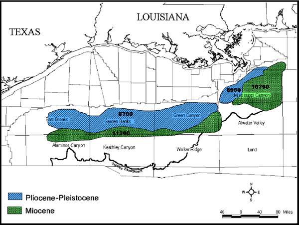