![]() Click to view page images in PDF format.
Click to view page images in PDF format.
PETROLEUM SYSTEM AND FUTURE PROSPECTS OF THE NORTH FALKLAND BASIN: POST-DRILLING ANALYSIS
By P. C. Richards*and B. V. Hillier**
Search and Discovery Article #10017 (2001)
Adaptation of article, entitled Post-Drilling Analysis of the North Falkland Basin—Part 2: Petroleum System and Future Prospects, by the same authors, published in Journal of Petroleum Geology, vol. 23 (3), July 2000, p. 273-292. Appreciation is expressed to the authors and to Christopher G. H. Tiratsoo, Scientific Press Ltd. and Journal of Petroleum Geology (www.jpg.co.uk).
*British Geological Survey, West Mains Road, Edinburgh, EH9 3LA.
**Shell Production and Development Ltd (Falklands Branch), Shell Centre, London.
Correspondence to [email protected].
ABSTRACT
Six wells were
drilled in the North Falkland Basin in 1998. Five of these wells recorded ![]() oil
oil![]() shows, and up to 32% gas was also recorded in mud returns to the rig floor.
However, none of the wells encountered commercially viable petroleum
accumulations.
shows, and up to 32% gas was also recorded in mud returns to the rig floor.
However, none of the wells encountered commercially viable petroleum
accumulations.
The syn-rift and
early post-rift intervals contain thick, lacustrine claystones with ![]() oil
oil![]()
![]() source
source![]() potential as indicated by TOC values up to 7. 5% and
potential as indicated by TOC values up to 7. 5% and ![]() Rock
Rock![]() -Eval S 2 values of up
to 102 kg HC per tonne of
-Eval S 2 values of up
to 102 kg HC per tonne of ![]() rock
rock![]() . These source rocks were immature or only
marginally mature in five of the wells but had attained maturity in one of them.
Modelling suggests that the main source interval may well be within the peak
. These source rocks were immature or only
marginally mature in five of the wells but had attained maturity in one of them.
Modelling suggests that the main source interval may well be within the peak ![]() oil
oil![]() generation window in deeper, undrilled parts of the basin. Calculations of the
amount of
generation window in deeper, undrilled parts of the basin. Calculations of the
amount of ![]() oil
oil![]() expelled range up to 60 billion barrels.
expelled range up to 60 billion barrels.
Most of the wells
tested a closely-related set of plays in large structures associated with a
sandstone interval near the top of the late syn-rift to early post-rift
source-![]() rock
rock![]() succession. Post-drilling geological modelling of the basin suggests
that
succession. Post-drilling geological modelling of the basin suggests
that ![]() oil
oil![]() is unlikely to have migrated into this sandstone play at the localities
tested, and that the wells consequently failed largely due to a lack of charge.
However, the play maintains exploration potential elsewhere. Other plays,
particularly those stratigraphically associated with the base rather than the
top of the source
is unlikely to have migrated into this sandstone play at the localities
tested, and that the wells consequently failed largely due to a lack of charge.
However, the play maintains exploration potential elsewhere. Other plays,
particularly those stratigraphically associated with the base rather than the
top of the source ![]() rock
rock![]() , may have a higher chance of exploration success.
, may have a higher chance of exploration success.
Click here for overlays of Figs. 1, 2, 3.
 Fig. 2. Plot of S 2 values (
![]() oil
oil![]() yield in kg HC per tonne of
yield in kg HC per tonne of ![]() rock
rock![]() ) against
depth (metres below KB) for the six wells in the North Falkland Basin.
) against
depth (metres below KB) for the six wells in the North Falkland Basin.
Click here for overlays of Figs. 1, 2, 3.
Click here for overlays of Figs. 1, 2, 3.
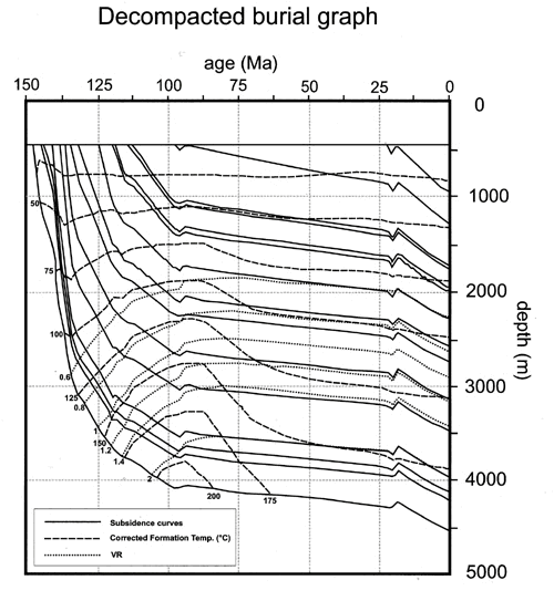
Click here for overlays of three curves of burial graph.
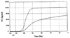 Fig. 5. Modelled
generation (solid line) and expulsion (dashed line) of
Fig. 5. Modelled
generation (solid line) and expulsion (dashed line) of ![]() oil
oil![]() from the base of the
main source
from the base of the
main source ![]() rock
rock![]() interval (the early post-rift lacustrine claystone). The
interval (the early post-rift lacustrine claystone). The ![]() oil
oil![]() generation/expulsion scale on the y-axis assumes a thickness of 400 m of mature
source rocks.
generation/expulsion scale on the y-axis assumes a thickness of 400 m of mature
source rocks.
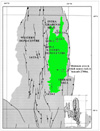 Fig.
6. Map of the base of the syn- to post-rift transitional unit, based on depth-
converted interpretation of seismic
data in the basin, showing the minimum area in which source rocks are buried
to depths greater than the 2,700 m threshold required for
Fig.
6. Map of the base of the syn- to post-rift transitional unit, based on depth-
converted interpretation of seismic
data in the basin, showing the minimum area in which source rocks are buried
to depths greater than the 2,700 m threshold required for ![]() oil
oil![]() generation.
generation.
Table 1. Source
![]() rock
rock![]() data (kerogen type, TOC, and
data (kerogen type, TOC, and ![]() Rock
Rock![]() -Eval pyrolysis results) for the
six wells in the North Falkland Basin.
-Eval pyrolysis results) for the
six wells in the North Falkland Basin.
Table 2.
Comparison of source-![]() rock
rock![]() characteristics for the North Falkland Basin and for
the Junggar Basin, NW China.
characteristics for the North Falkland Basin and for
the Junggar Basin, NW China.
Table 4. Summary of ![]() oil
oil![]() sample
characteristics from Wells 14/5-1A, 14/10-1, 14/9-1 and 14/24-1.
sample
characteristics from Wells 14/5-1A, 14/10-1, 14/9-1 and 14/24-1.
SOURCE ROCKS IN THE NORTH FALKLAND BASIN
Source rocks in the Early syn-rift sequence (?mid Jurassic to ?Tithonian)
Source rocks in the late syn-rift sequence (Tithonian to Berriasian)
Comparisons with source rocks in other basins
Timing
of ![]() oil
oil![]() generation
generation
POTENTIAL RESERVOIR ROCKS IN THE NORTH FALKLAND BASIN
Early and late syn-rift potential reservoir rocks (mid-Jurassic to Berriasian)
Early post-rift reservoir rocks (Valanginian to early Aptian)
Middle psot-rift reservoir rocks (Aptian to Albian)
TRAPS, SEALS AND MIGRATION ROUTES
Syn-rift sandstones on the crests of tilted fault blocks
Middle post-rift transgressive and fluvial sandstones
Early post-rift axial delta play and associated basin floor sandstones
Fan sandstones along the eastern margin of the Eastern Depocentre
Laterally-derived delta sandstones along both basin margins
Basin margin sandstones developed during overstepping of the eastern rift shoulder
Closed high plays to the south of the drilled areas
Possible analogues in the East African Rift Valley
Several attempts were made before drilling to predict the nature of the North Falkland Basin’s fill and its petroleum potential (Richards et al., 1996 a and b; Richards and Fannin, 1997; Thomson and Underhill, 1999; Bransden et al., 1999; Lawrence et al., 1999). In a companion article, Richards and Hillier (2000) summarize the new tectono-stratigraphic model which has been developed for the basin using all the existing well and seismic data from the region. Presented here is a summary of the petroleum-related results of the six exploration wells which were drilled in the North Falkland Basin in the period April to November, 1998.
The oldest Mesozoic sedimentary rocks in the North Falkland Basin are Jurassic to Valanginian, early and late syn-rift successions of predominantly fluvio-lacustrine origin. The succeeding, post-rift, thermal sag deposits can be divided into five units (Richards and Hillier, 2000): a transitional unit characterized by lacustrine sedimentation; an early post-rift unit also characterized by lacustrine sedimentation, but with evidence of deltaic deposition from the northern, western and eastern margins of the basin; a middle post-rift phase characterized by the re-establishment of fluvial conditions; a late post-rift phase characterized by a transition from marginal-marine/fluvial more open-marine conditions; and a post-uplift sag phase unit recording open-marine conditions.
This study presents a summary of the results of the principal investigations into the nature of the petroleum system of the North Falkland Basin. A detailed breakdown of the proprietary analyses conducted for each well is beyond the scope of this paper, and accordingly only a summary of the salient features of the petroleum system is given.
Geochemical analyses
were conducted by each operating company (using a number of different
laboratories), in order to determine the nature and maturity of the source
rocks. Analyses included measurements of TOC and vitrinite reflectance. ![]() Rock
Rock![]() -Eval
pyrolysis was conducted on samples from each well, with the results
comprising S 1 (amount of free-hydrocarbons), S 2 (hydrocarbon-generating
potential), S 3 (volume of CO 2 evolved during pyrolysis), together with T max,
Hydrogen Index (HI), Oxygen Index (OI), and Production Index (PI). Oils
recovered at surface while drilling, together with samples centrifugally spun
from cores, were also analyzed in order to compare their isotope geochemistry
with that of the source rocks studied. Burial history modelling was conducted
independently by each company and by the authors, using a variety of heat-flow
scenarios. Porosity and permeability measurements and petrological
determinations from conventional and side-wall cores were integrated with
petrophysical log readings in order to calculate water saturations (Sw) and log
porosities.
-Eval
pyrolysis was conducted on samples from each well, with the results
comprising S 1 (amount of free-hydrocarbons), S 2 (hydrocarbon-generating
potential), S 3 (volume of CO 2 evolved during pyrolysis), together with T max,
Hydrogen Index (HI), Oxygen Index (OI), and Production Index (PI). Oils
recovered at surface while drilling, together with samples centrifugally spun
from cores, were also analyzed in order to compare their isotope geochemistry
with that of the source rocks studied. Burial history modelling was conducted
independently by each company and by the authors, using a variety of heat-flow
scenarios. Porosity and permeability measurements and petrological
determinations from conventional and side-wall cores were integrated with
petrophysical log readings in order to calculate water saturations (Sw) and log
porosities.
SOURCE ROCKS IN THE NORTH FALKLAND BASIN
Extensive analyses
have been conducted on claystones from all six wells. A complete review and
listing of all the geochemical data available is beyond the scope of this paper,
but a summary of TOC, ![]() Rock
Rock![]() -Eval S 2 and vitrinite reflectance (VR) values
recorded in the six wells is presented graphically in Figs.
1, 2 and 3. Key
source
-Eval S 2 and vitrinite reflectance (VR) values
recorded in the six wells is presented graphically in Figs.
1, 2 and 3. Key
source ![]() rock
rock![]() data from the six wells are also presented in Table 1.
data from the six wells are also presented in Table 1.
Although source ![]() rock
rock![]() data were collected and analyzed from all the wells in the basin, source-
data were collected and analyzed from all the wells in the basin, source-![]() rock
rock![]() evaluation is probably best illustrated with reference to the claystone-rich
intervals in Wells 14/5-1A and 14/10-1, which were drilled in a
basinal setting within the Eastern Depocentre (Richards and Hillier, 2000 Figs. 1 and
2). The
nature of the source rocks in the syn-rift to early post-rift intervals in these
wells is discussed below.
evaluation is probably best illustrated with reference to the claystone-rich
intervals in Wells 14/5-1A and 14/10-1, which were drilled in a
basinal setting within the Eastern Depocentre (Richards and Hillier, 2000 Figs. 1 and
2). The
nature of the source rocks in the syn-rift to early post-rift intervals in these
wells is discussed below.
Source rocks in the early syn-rift sequence (?mid Jurassic to ?Tithonian)
Average TOC values for this unit in Well 14/5-1A were 0. 76%, but
ranged up to 1. 6%. Although there are lacustrine components within this
succession, it contains more fluviatile sediments than the overlying claystone-dominated
units, and the depositional setting may have been relatively unfavourable for
source-![]() rock
rock![]() preservation. However, post-mature Type II source rocks are present
below 4, 150m in Well 14/5-1A. Vitrinite reflectance studies suggest that
the transition from wet gas/condensate to dry gas occurs at around 3, 762m in
Well 14/5-1A, while significant levels of gas (up to 32% ) are recorded
from this unit below 4, 000 m.
preservation. However, post-mature Type II source rocks are present
below 4, 150m in Well 14/5-1A. Vitrinite reflectance studies suggest that
the transition from wet gas/condensate to dry gas occurs at around 3, 762m in
Well 14/5-1A, while significant levels of gas (up to 32% ) are recorded
from this unit below 4, 000 m.
Source rocks in the late syn-rift sequence (Tithonian to Berriasian)
In Wells 14/5-1A and 14/10-1, the late syn-rift sequence is
characterized by highly mature, predominantly Type II source rocks. The unit has
average TOC values of 1. 6% in the two wells, although values range up to 7. 5%
in one of the other wells. Average values of ![]() Rock
Rock![]() - Eval S 2 in well 14/5-1A are 5. 6 kg HC/tonne
- Eval S 2 in well 14/5-1A are 5. 6 kg HC/tonne ![]() rock
rock![]() , with values as high as 77 kg HC/tonne recorded
from one sample (Table 1). Vitrinite reflectance values of 0. 9% were recorded
for claystones at 3, 000m below KB in Well 14/10-1, placing the sequence
at the very base of this well within the zone of peak
, with values as high as 77 kg HC/tonne recorded
from one sample (Table 1). Vitrinite reflectance values of 0. 9% were recorded
for claystones at 3, 000m below KB in Well 14/10-1, placing the sequence
at the very base of this well within the zone of peak ![]() oil
oil![]() generation.
generation.
Source rocks in the syn-to post-rift transition (Berriasian to Valanginian) and early post-rift sequence (Valanginian to early Aptian)
These claystone-dominated
units are here treated together because they form the main lacustrine
source-![]() rock
rock![]() interval in the North Falkland Basin. The TOC content of the
claystones generally increases downwards through this interval. TOC values reach
7. 5% near the base of the units in Well 14/5-1A. The downward increase
in TOC values corresponds to a downward decrease in sonic log velocity values
recorded in all the wells (Richards and Hillier, 2000, Fig. 2). The downward increase in TOC
values is accompanied by a general downward increase in
interval in the North Falkland Basin. The TOC content of the
claystones generally increases downwards through this interval. TOC values reach
7. 5% near the base of the units in Well 14/5-1A. The downward increase
in TOC values corresponds to a downward decrease in sonic log velocity values
recorded in all the wells (Richards and Hillier, 2000, Fig. 2). The downward increase in TOC
values is accompanied by a general downward increase in ![]() Rock
Rock![]() - Eval S 2
values, from 3 kg HC/tonne at the top, to over 69 kg HC/tonne in places in Well 14/10-1.
However, S 2 values of over 100 kg HC/tonne were recorded from one sample in
Well 14/24-1 (Table 1).
- Eval S 2
values, from 3 kg HC/tonne at the top, to over 69 kg HC/tonne in places in Well 14/10-1.
However, S 2 values of over 100 kg HC/tonne were recorded from one sample in
Well 14/24-1 (Table 1).
The organic matter in this claystone-dominated interval is mainly composed of Type I kerogens, principally alginite or lamalginite. Minor amounts of organic matter derived from terrestrial plants are also present. The algae are composed primarily of small unicellular types with some larger Botryococcus, and indicate deposition in a lacustrine environment. The bottom of the lake was probably well oxygenated during the later stages of the early-post rift interval, when a major, southwards-prograding axial delta (Richards and Hillier, 2000) may have contributed to frequent overturning of the water column. However, the sudden downward increase in well-preserved algal matter below the foresets of the younger portion of delta (i. e. below about 2,050m in Well 14/5-1A ) indicates a change to more anaerobic bottom conditions. The transitional unit at the base of the claystone interval was probably deposited under slightly more oxygenated conditions than the overlying unit (Richards and Hillier, 2000).
Comparisons with source rocks in other basins
The greyish-brown lacustrine source rocks occurring within the late syn-rift
to early post- rift sections are lithologically similar to the Upper Permian
lacustrine source rocks of the southern Junggar Basin of NW China. Carroll et
al. (1992) described these rocks as ranking amongst the richest petroleum
source rocks in the World, with TOC values up to 34% and ![]() Rock
Rock![]() -Eval S 2
yields of up to 200 kg HC/tonne of
-Eval S 2
yields of up to 200 kg HC/tonne of ![]() rock
rock![]() . While these maximum values are
significantly higher than those recorded in the North Falkland Basin, the
average values for both source
. While these maximum values are
significantly higher than those recorded in the North Falkland Basin, the
average values for both source ![]() rock
rock![]() intervals are much closer together (Table 2).
intervals are much closer together (Table 2).
Source Potential Index
(SPI) values (Demaison and Huizinga, 1991) can be calculated for any potential
source ![]() rock
rock![]() using the formula:
using the formula:
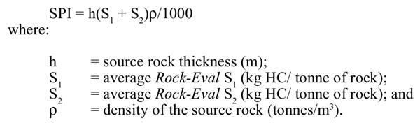
SPI values for the
North Falkland Basin lacustrine sequences vary according to the units studied
(Table 3). The average SPI for the entire source-![]() rock
rock![]() interval, spanning the syn-rift
through early post-rift successions, is 62. 5. This calculation is based on an
estimate of total source-
interval, spanning the syn-rift
through early post-rift successions, is 62. 5. This calculation is based on an
estimate of total source-![]() rock
rock![]() thickness of 2, 205 m, an average S 1 of 2. 14, an
average S 2 of 10. 19, and a density of 2. 3.
thickness of 2, 205 m, an average S 1 of 2. 14, an
average S 2 of 10. 19, and a density of 2. 3.
The SPI value for the
Valanginian to early Aptian, early post-rift unit only (the interval with the
highest TOC values) is calculated to be 49. 2, based on an estimated h =485 m,
average S 1 =3. 7, average S 2 =40. 4 and ñ =2. 3. The SPI for the late syn-rift
(Tithonian to Berriasian) and the rift to post-rift Transitional Unit (Berriasian
to Valanginian) is 21. 5 (h = 820 m, average S 1 =4. 56, average S 2 =6. 83, and
ñ =2. 3) :this interval does not contain as much organic carbon as the younger
sequences. The stratigraphically lower units are probably within the main ![]() oil
oil![]() generation window, and they are therefore probably the units that are best
suited to comparison with source rocks from
generation window, and they are therefore probably the units that are best
suited to comparison with source rocks from ![]() oil
oil![]() -producing basins elsewhere
(Table 3). Based on SPI values, the late syn-rift and transitional units in the
North Falkland Basin may constitute the seventh-best source
-producing basins elsewhere
(Table 3). Based on SPI values, the late syn-rift and transitional units in the
North Falkland Basin may constitute the seventh-best source ![]() rock
rock![]() known
(excluding overlying, less mature units in the same basin) on the basis of the
available data.
known
(excluding overlying, less mature units in the same basin) on the basis of the
available data.
The early post-rift
and Transitional Unit claystones that form the primary source ![]() rock
rock![]() interval in
the North Falkland Basin are located in a tectono-stratigraphic setting similar
to that of the Aptian ?marine early sag succession in the Colorado Basin,
offshore Buenos Aires Province, Argentina. Bushnell et al. (1997)
described this undrilled unit as potentially the most promising source-
interval in
the North Falkland Basin are located in a tectono-stratigraphic setting similar
to that of the Aptian ?marine early sag succession in the Colorado Basin,
offshore Buenos Aires Province, Argentina. Bushnell et al. (1997)
described this undrilled unit as potentially the most promising source-![]() rock
rock![]() succession in the basin. In common with the early post-rift source
succession in the basin. In common with the early post-rift source ![]() rock
rock![]() of the
North Falkland Basin, it is characterized on seismic sections by a package of
high amplitude reflectors (Richards and Hillier, 2000). However, the unit in the Colorado Basin
is currently buried to depths of more than 5, 000 m below sea level, and is
therefore below the
of the
North Falkland Basin, it is characterized on seismic sections by a package of
high amplitude reflectors (Richards and Hillier, 2000). However, the unit in the Colorado Basin
is currently buried to depths of more than 5, 000 m below sea level, and is
therefore below the ![]() oil
oil![]() -generation window (Bushnell et al., 1997).
-generation window (Bushnell et al., 1997).
The main source ![]() rock
rock![]() in the nearby Malvinas Basin is the Barremian to Aptian, Lower Inoceramus
Formation, described by Galeazzi (1998) as a regressive wedge deposited in an
anoxic marine setting. This source
in the nearby Malvinas Basin is the Barremian to Aptian, Lower Inoceramus
Formation, described by Galeazzi (1998) as a regressive wedge deposited in an
anoxic marine setting. This source ![]() rock
rock![]() contains Types II and III kerogens, and
is more closely comparable to Cretaceous anoxic-marine claystones described by
Jacquin and Graciansky (1988) from DSDP drill sites on the Maurice Ewing Bank,
to the East of the Falkland Islands, than to the lacustrine claystones of the
North Falkland Basin.
contains Types II and III kerogens, and
is more closely comparable to Cretaceous anoxic-marine claystones described by
Jacquin and Graciansky (1988) from DSDP drill sites on the Maurice Ewing Bank,
to the East of the Falkland Islands, than to the lacustrine claystones of the
North Falkland Basin.
Modelling the timing of ![]() oil
oil![]() generation is imprecise because it is difficult
to define precisely the time of peak heat-flow in the basin:it may have been
either from about 150 to 125 Ma (during Jurassic to Valanginian rifting), or
around 90 Ma (during the post-rift phase, perhaps associated with the opening of
the South Atlantic). A regional unconformity has been recognized in the Turonian
at about 90 Ma (Richards and Hillier, 2000). This presumably represents a phase of regional
uplift and crustal thinning, and could therefore be associated with increased
heat flows at that time.
generation is imprecise because it is difficult
to define precisely the time of peak heat-flow in the basin:it may have been
either from about 150 to 125 Ma (during Jurassic to Valanginian rifting), or
around 90 Ma (during the post-rift phase, perhaps associated with the opening of
the South Atlantic). A regional unconformity has been recognized in the Turonian
at about 90 Ma (Richards and Hillier, 2000). This presumably represents a phase of regional
uplift and crustal thinning, and could therefore be associated with increased
heat flows at that time.
A number of burial
history models with varying heat-flows have been calculated for the basin. A
model with a peak heat-flow of around 80 mW/m 2 at 90 Ma (Fig.
4) was found to
most closely match the observed VR, temperature and geochemical data, and
indicates that ![]() oil
oil![]() generation took place from the early post-rift source
generation took place from the early post-rift source ![]() rock
rock![]() during the Late Cretaceous, between 70 and 100 Ma (Fig.
5). This model suggests
that at a depth of around 3, 000m below sea level, over 50% of the organic
material will have been converted to
during the Late Cretaceous, between 70 and 100 Ma (Fig.
5). This model suggests
that at a depth of around 3, 000m below sea level, over 50% of the organic
material will have been converted to ![]() oil
oil![]() . Modelling based on an earlier
heat-flow peak (around 125Ma) results in peak
. Modelling based on an earlier
heat-flow peak (around 125Ma) results in peak ![]() oil
oil![]() generation around the present
day, but suggests that there would be only about 2% conversion of organic matter
and this is not consistent with the maturation analyses carried out on the
source rocks themselves. A third model, with a heat-flow peak at around 112 Ma
and with an estimated source
generation around the present
day, but suggests that there would be only about 2% conversion of organic matter
and this is not consistent with the maturation analyses carried out on the
source rocks themselves. A third model, with a heat-flow peak at around 112 Ma
and with an estimated source ![]() rock
rock![]() interval at 3, 400m below sea level (feasible
for deeper, undrilled parts of the basin), predicts about 35% organic matter
conversion to
interval at 3, 400m below sea level (feasible
for deeper, undrilled parts of the basin), predicts about 35% organic matter
conversion to ![]() oil
oil![]() but with maximum expulsion occurring in the Aptian.
but with maximum expulsion occurring in the Aptian.
Burial history modelling of the (relatively lean) deeper potential source rocks of mid-Jurassic to Berriasian age within the early and late syn-rift successions suggests that they are currently post-mature, but have possibly been a (marginal) source, mostly for gas. They probably reached peak generation in the Early Cretaceous, with most of the hydrocarbons expelled by about 90 Ma (Cenomanian to Turonian).
![]() Oil
Oil![]() or
or ![]() oil
oil![]() and gas
shows were encountered in five of the six wells, but the only hydrocarbons that
flowed to surface were waxy oils (27 ° API) from Well 14/10-1. The shows
were recorded from reservoir rocks at various levels, and also while drilling
through the late syn-rift to early post-rift interval, apparently seeping
directly from the source. The characteristics of these
and gas
shows were encountered in five of the six wells, but the only hydrocarbons that
flowed to surface were waxy oils (27 ° API) from Well 14/10-1. The shows
were recorded from reservoir rocks at various levels, and also while drilling
through the late syn-rift to early post-rift interval, apparently seeping
directly from the source. The characteristics of these ![]() oil
oil![]() samples are
summarized in Table 4.
samples are
summarized in Table 4.
Oils within the middle
post-rift sandstones in Well 14/9-1, and those recovered from the late
syn-rift succession in Well 14/10-1, were derived from the lowermost part
of the early post-rift lacustrine, Type I source ![]() rock
rock![]() . By contrast, shows in the
middle post-rift sandstones in Well 14/5-1A are from a different, Type II
source
. By contrast, shows in the
middle post-rift sandstones in Well 14/5-1A are from a different, Type II
source ![]() rock
rock![]() , characteristic of the late syn-rift succession. The
, characteristic of the late syn-rift succession. The ![]() oil
oil![]() recovered
from near the base of Well 14/10-1 was probably expelled downwards from
the early post-rift succession, whereas the
recovered
from near the base of Well 14/10-1 was probably expelled downwards from
the early post-rift succession, whereas the ![]() oil
oil![]() spun from the middle post-rift
core in well 14/9-1 appears to have migrated vertically and laterally for
at least six kilometres from a deeper kitchen area, as have the
spun from the middle post-rift
core in well 14/9-1 appears to have migrated vertically and laterally for
at least six kilometres from a deeper kitchen area, as have the ![]() oil
oil![]() shows
recorded from the middle post-rift sandstones in Well 14/5-1A. The
vertical migration pathway appears to have been less efficient than the downward
migration pathway, because live oils were recovered from horizons below the main
source interval but only shows were reported from above (see below for further
discussion of migration pathways).
shows
recorded from the middle post-rift sandstones in Well 14/5-1A. The
vertical migration pathway appears to have been less efficient than the downward
migration pathway, because live oils were recovered from horizons below the main
source interval but only shows were reported from above (see below for further
discussion of migration pathways).
Gas shows observed during drilling ranged from less than 1% to in excess of 32% in the early syn-rift sequence in Well 14/5-1A (from thin sandstones in a unit comprising about 120 m of net sandstone — Richards and Hillier, 2000) ). Gases were dominated by C 1 types with minor amounts of C 2 and C 3, although high levels of C 2 to C 5 were also recorded locally. Gas shows in the stratigraphically-higher sandstones are generally less voluminous with, for example, up to 2, 900 ppm C 1 and only traces of C 2 recorded from the middle post-rift sandstones in Well 14/ 9-2. Gas shows directly from syn-rift and early post-rift lacustrine claystones are up to 12. 1% (in Well 14/10-1 ), with a complete range of C 1 through C 5 gases recorded.
POTENTIAL RESERVOIR ROCKS IN THE NORTH FALKLAND BASIN
All six exploration wells encountered potential reservoir rocks, ranging in age from Late Jurassic to Late Cretaceous. Lower Cretaceous potential reservoirs were most commonly encountered, particularly within the early and middle post-rift units. The lithologies of these intervals were described in Richards and Hillier (2000).
Early and late syn-rift potential reservoir rocks (mid-Jurassic to Berriasian)
Several siliciclastic reservoir intervals were encountered within these units in Well 14/5- 1A. One sand-dominated, early syn-rift interval has a net reservoir thickness of nearly 40m, with porosities of 4. 4 to 7. 5% ; a second early syn-rift interval has a net thickness of over 10 m but porosities of only up to 4. 6% ; a third reservoir interval, which spans the boundary between the early and late syn-rift sequences in Well 14/5-1A, has net a thickness of 74m and porosities of up to 9. 0%. The thickest late syn-rift reservoir interval in Well 14/5-1A has a net thickness of 125m, with porosities ranging from 27. 8 to 30. 4% and Sw values as low as 51%. Although these net sand values are relatively high, the sandstones themselves are thinly bedded.
Well 14/10-1 also encountered two thin, late syn-rift reservoir intervals. The lower of these had a net thickness of 1. 2 m; the upper had a net thickness of 2. 4 m. Both of these sandstones had log-derived Sw values as low as 36%. Well 14/9-1 also encountered potential reservoir within the late syn-rift sequence, with porosities of up to 30% and water saturations as low as 70%, but sampling using a wireline formation tester was unsuccessful, suggesting that the sandstones were tight.
Early post-rift reservoir rocks (Valanginian to early Aptian)
Early post-rift sandstones were only encountered in Well 14/5-1A, where they form part of the southerly-prograding axial delta deposits in the Eastern Depocentre. A sandstone-dominated interval identified within the delta foresets contained 38m of net sandstone reservoir, with up to 28% porosity and 974 mD permeability, but 89% water saturation.
Middle post-rift reservoir rocks (Aptian to Albian)
Middle post-rift reservoir sandstones were deposited in a transgressive, fluvio-lacustrine setting following the end of lacustrine deposition. Therefore, these reservoir rocks lie immediately above the main source interval. They are present in all of the wells. In Well 14/5- 1A, the sandstones have a net thickness of nearly 23m, with a net-to-gross ratio of 0. 56 and a porosity range of 19. 6 to 25. 4%. Furthermore, 79 m of net sandstone in this interval were encountered in Well 14/10-1, while over 133 m of net sandstone were found in Well 14/24-1.
These sandstones
constituted a prime exploration target in four of the wells, and an important
secondary target in the other two. However, the relatively low permeabilities
and high water saturations, together with the common occurrence of
pore-throat-blocking kaolinite cements, has reduced their reservoir quality.
Furthermore, their effectiveness as a trap for hydrocarbons migrating from the
underlying source ![]() rock
rock![]() interval may be limited by the sealing nature of the
uppermost parts of the claystone interval, which may have acted as a barrier to
vertical fluid migration (see discussions below of migration routes and seals).
interval may be limited by the sealing nature of the
uppermost parts of the claystone interval, which may have acted as a barrier to
vertical fluid migration (see discussions below of migration routes and seals).
In summary, some significant sandstone reservoir intervals have been encountered. Well 14/5-1A encountered a total of 390 m of net reservoir (deltaic and fluvial sandstones) with an average porosity of 13% ; while Well 14/10-1 had a total of 84 m of net sandstones, with porosities averaging 27. 5%.
TRAPS, SEALS AND MIGRATION ROUTES
A number of different trap styles were tested by the six wells drilled in the North Falkland Basin. Four of the wells tested four-way dip closures with reservoirs in the middle post-rift succession. Well 14/9-1 was designed to test early and late syn-rift sandstones within a tilted fault block forming part of the Intra-Graben High, in addition to the four-way drape at the top of the early post-rift level. Well 14/9-2 was designed to test a syn-rift closed high on the eastern flank of the Intra-Graben High. Well 14/13-1 was designed to test a similar structure within the Western Depocentre (the so-called Minke High). Wells 14/5-1A and 14/10-1 tested four-way dip closures within the early post-rift sequence, in addition to the middle post-rift drapes.
An understanding of
migration pathways and seals may provide the key to predicting the presence of
hydrocarbon accumulations in the North Falkland Basin. The most effective top
seal is probably provided by the early post-rift source ![]() rock
rock![]() itself, just as the
Kimmeridge Clay Formation acts as both source and regional seal in the central
and northern North Sea. The uppermost 600 m or so of the early post-rift
claystone interval is above the
itself, just as the
Kimmeridge Clay Formation acts as both source and regional seal in the central
and northern North Sea. The uppermost 600 m or so of the early post-rift
claystone interval is above the ![]() oil
oil![]() generation window in the central parts of
the Eastern Depocentre. Headspace gas analyses suggest that there has been no
vertical migration of gas through this claystone, pointing to its viability as
an effective seal.
generation window in the central parts of
the Eastern Depocentre. Headspace gas analyses suggest that there has been no
vertical migration of gas through this claystone, pointing to its viability as
an effective seal.
The main source ![]() rock
rock![]() interval (the Valanginian to early Aptian, early
post-rift sequence) is represented on seismic sections by a Low Velocity Zone (LVZ),
and before drilling this was thought to represent an overpressured zone.
However, no overpressures were recorded in the basin during drilling, and the
LVZ represents an extremely organic rich interval with a low density:the low
density values, and a downwards decrease in density with depth is accompanied by
a downwards increase in TOC values in each well (Fig.
1), and also by a
downwards increase in
interval (the Valanginian to early Aptian, early
post-rift sequence) is represented on seismic sections by a Low Velocity Zone (LVZ),
and before drilling this was thought to represent an overpressured zone.
However, no overpressures were recorded in the basin during drilling, and the
LVZ represents an extremely organic rich interval with a low density:the low
density values, and a downwards decrease in density with depth is accompanied by
a downwards increase in TOC values in each well (Fig.
1), and also by a
downwards increase in ![]() Rock
Rock![]() -Eval S 2 values (Fig.
2) which represent a
downwards increase in hydrocarbon expulsion.
-Eval S 2 values (Fig.
2) which represent a
downwards increase in hydrocarbon expulsion.
Since the claystones
are not overpressured, the fluid-flow system beneath the claystones is not
confined and hydrocarbons are therefore more likely to have migrated laterally
down- section, along migration channels provided by sandstones within or just
below the claystones. This type of migration would tend to favour the
accumulation of ![]() oil
oil![]() either near the basin margin in marginally-attached fans, in
tilted fault blocks stratigraphically beneath the claystone blanket, or in syn-rift
reservoirs along features such as the Intra-Graben High. Thus, it is possible
that the syn-rift succession penetrated in Well 14/9-1, which was found
to have poor reservoir qualities at this location, may be a viable target at
other sites along the Intra-Graben High. Some younger, middle post-rift targets
may also be viable if they are near to faults which breach the early post-rift
claystone seal.
either near the basin margin in marginally-attached fans, in
tilted fault blocks stratigraphically beneath the claystone blanket, or in syn-rift
reservoirs along features such as the Intra-Graben High. Thus, it is possible
that the syn-rift succession penetrated in Well 14/9-1, which was found
to have poor reservoir qualities at this location, may be a viable target at
other sites along the Intra-Graben High. Some younger, middle post-rift targets
may also be viable if they are near to faults which breach the early post-rift
claystone seal.
Analyses of the oils
recovered at the surface and observed as shows tend to confirm the model of
preferential downwards migration. Only ![]() oil
oil![]() shows were observed in apparently
under- charged sandstones above the main early post-rift source interval,
whereas live
shows were observed in apparently
under- charged sandstones above the main early post-rift source interval,
whereas live ![]() oil
oil![]() was recovered from beneath the early post-rift source
was recovered from beneath the early post-rift source ![]() rock
rock![]() in
Well 14/10-1.
in
Well 14/10-1.
An unconfined
migration system could mean that relatively long-distance, lateral migration
into syn-rift sandstones within the Western Depocentre is a possibility.
Therefore, structures such as the Minke High (drilled by Well 14/13-1 )
could contain ![]() oil
oil![]() where they comprise syn- rift sedimentary rocks rather than
basement. Because Well 14/13-1 did not penetrate beneath the base of the
claystone, it is not known whether syn-rift sandstones are present within that
structure or down-flank to the east of the well location.
where they comprise syn- rift sedimentary rocks rather than
basement. Because Well 14/13-1 did not penetrate beneath the base of the
claystone, it is not known whether syn-rift sandstones are present within that
structure or down-flank to the east of the well location.
In summary, it
seems probable that the main source ![]() rock
rock![]() interval provides an efficient vertical
barrier to migration, and this possibly explains why only small amounts of
interval provides an efficient vertical
barrier to migration, and this possibly explains why only small amounts of ![]() oil
oil![]() were able to migrate from the mature, basal parts of the source
were able to migrate from the mature, basal parts of the source ![]() rock
rock![]() interval up
into the middle post- rift transgressive and fluvial sandstones penetrated in
all six wells. However, vertical migration into the middle post-rift sandstones
may be possible where traps lie close to penetrative faults which provide a
migration pathway down into the main kitchen area in the Eastern Depocentre,
particularly adjacent to the basin margins. Lateral migration beneath the
claystones and then into sub-source
interval up
into the middle post- rift transgressive and fluvial sandstones penetrated in
all six wells. However, vertical migration into the middle post-rift sandstones
may be possible where traps lie close to penetrative faults which provide a
migration pathway down into the main kitchen area in the Eastern Depocentre,
particularly adjacent to the basin margins. Lateral migration beneath the
claystones and then into sub-source ![]() rock
rock![]() tilted fault blocks, fans attached to
the eastern margin, or syn-rift sandstones in places along the Intra-Graben
High, is possibly the most efficient migration pathway in the basin.
tilted fault blocks, fans attached to
the eastern margin, or syn-rift sandstones in places along the Intra-Graben
High, is possibly the most efficient migration pathway in the basin.
Large volumes of ![]() oil
oil![]() may have been generated in the basin, but there are only relatively minor shows
in post-rift traps, while syn-rift traps have not been adequately tested.
may have been generated in the basin, but there are only relatively minor shows
in post-rift traps, while syn-rift traps have not been adequately tested.
A variety of play types were planned to be targeted by the 1998 drilling campaign, but post- well analyses indicate that only three play types were actually partially tested. These tested plays were the early post-rift deltas, the middle post-rift transgressive and fluvial sandstones, and the syn-rift succession in the core of the Intra-Graben High. More untested than partially-tested plays remain in the basin and a selection of both types are reviewed below.
Syn-rift sandstones on the crests of tilted fault blocks
Only Well 14/9-1 tested this play within closure on the crest of the Intra-Graben High. The mid-Jurassic to Berriasian sandstones encountered on the Intra-Graben High had reasonable reservoir properties, particularly those within the Tithonian to Berriasian, late syn-rift unit: log-derived porosities up to 30% and Sw values as low as 70% were recorded. Although permeabilities appear to be poor at the 14/9-1 location, the prospectivity of the syn-rift succession cannot be ruled out elsewhere.
Two thin sandstone
beds (3-and 5-m thick) were also penetrated in the late syn-rift sequence by
Well 14/10-1, in a palaeo-lake centre setting. It is thought that these
two sandstones were not within closure at the level they were encountered, and
therefore were not fully ![]() oil
oil![]() charged. However, both the sandstones had
charged. However, both the sandstones had ![]() oil
oil![]() shows, with porosities of about 19% and Sw values of about 36%. These
characteristics indicate that the syn-rift succession may have considerable
reservoir potential. The play has been only partially tested and may merit
further drilling at other locations, particularly on the eastern flank of the
Intra-Graben High. The syn-rift succession should not be taken to represent
economic basement in the region without considerable further drilling data being
acquired.
shows, with porosities of about 19% and Sw values of about 36%. These
characteristics indicate that the syn-rift succession may have considerable
reservoir potential. The play has been only partially tested and may merit
further drilling at other locations, particularly on the eastern flank of the
Intra-Graben High. The syn-rift succession should not be taken to represent
economic basement in the region without considerable further drilling data being
acquired.
Middle post-rift transgressive and fluvial sandstones
All six wells
encountered reservoir quality sandstones within the Aptian to Albian middle
post-rift unit that directly overlies the main source-![]() rock
rock![]() succession, and five
of them had
succession, and five
of them had ![]() oil
oil![]() shows. The play has been only partially tested and may merit
further exploration, particularly if viable migration pathways can be mapped.
For example, there are several relatively shallow closures along the crest of
the Intra-Graben High. These closures may also be located immediately adjacent
to a fault which breaches the early post-rift seal, and which provides a direct
migration pathway from the kitchen area in the middle of the Eastern Depocentre.
shows. The play has been only partially tested and may merit
further exploration, particularly if viable migration pathways can be mapped.
For example, there are several relatively shallow closures along the crest of
the Intra-Graben High. These closures may also be located immediately adjacent
to a fault which breaches the early post-rift seal, and which provides a direct
migration pathway from the kitchen area in the middle of the Eastern Depocentre.
Early post-rift axial delta play and associated basin floor sandstones
Only Well 14/5-1A addressed the Valanginian to early Aptian, early post-rift axial delta play. Thick sandstones are likely to occur at delta-top and delta-front levels to the north of the 14/5-1A well location, but there is very little seismic data in that area at present. Possible channel features which have been imaged appear to cut into the front of the delta in the Eastern Depocentre, and may also have significant potential especially as they are encased in source rocks which may provide a straightforward migration pathway and therefore relatively easy charge. They may also have carried sand further out into the lacustrine basin, into as yet undrilled acreage, which is only sparsely covered by seismic data.
Fan sandstones along the eastern margin of the Eastern Depocentre
Jurassic to earliest
Cretaceous fan sandstones, deposited during the syn-rift phase, may be developed
along the margins of the basin in situations analogous to the Brae complex in
the South Viking Graben. Such sandstones would be stratigraphically subjacent to
the mature, basal part of the source ![]() rock
rock![]() , and may therefore be likely to be
charged with hydrocarbons. Fan-like bodies have been mapped in places along the
basin margin, but are difficult to identify on existing seismic data.
, and may therefore be likely to be
charged with hydrocarbons. Fan-like bodies have been mapped in places along the
basin margin, but are difficult to identify on existing seismic data.
Laterally-derived delta sandstones along both basin margins
Early Cretaceous deltaic bodies that prograded into the basin from marginal areas during the early post-rift phase may be sand-rich and may also be closer to migration pathways, particularly those associated with the basin-margin faults. They may therefore be more to likely to have been charged with hydrocarbons than sandstones within the axial delta. It is difficult to identify their distribution with any certainty using existing seismic data, but they may be significantly more extensive than is currently thought.
Basin margin sandstones developed during overstepping of the eastern rift shoulder
Shoreline and/or
transgressive sandstones of Aptian to Albian age may have been deposited along
the margins of the basin during the initial overstepping of the flanks in the
middle post- rift phase. Although such sandstones would be stratigraphically
above the main mature part of the source ![]() rock
rock![]() succession, they might have been
charged by fluid flow up basin-margin faults.
succession, they might have been
charged by fluid flow up basin-margin faults.
Closed high plays to the south of the drilled areas
Mapping of the 2D
seismic data acquired by Desire Petroleum during 1998 in the southern part of
the North Falkland Basin is not yet complete, but early results point to the
presence of numerous closed highs in a number of discrete, deep sub-basins that
extend to at least four seconds of two-way-travel time. No definitive
correlations have yet been established with the drilled areas to the north,
although it seems likely that the deeper parts of the section equate with the
early syn-rift sediments penetrated in Well 14/5-1A. These sediments were
the source of gas in that well, although they are capable of generating ![]() oil
oil![]() where less deeply buried.
where less deeply buried.
Good quality source
rocks, reservoirs, seals and traps have been identified in the North Falkland
Basin. Although ![]() oil
oil![]() was recovered at surface in small quantities, the structures
and primary reservoir targets drilled by the six wells did not contain
commercially viable accumulations of hydrocarbons. However, all of the elements
of a working petroleum system are present in the basin, suggesting that further
drilling, planned using information such as that derived from this post-well
analysis, could lead to better commercial results.
was recovered at surface in small quantities, the structures
and primary reservoir targets drilled by the six wells did not contain
commercially viable accumulations of hydrocarbons. However, all of the elements
of a working petroleum system are present in the basin, suggesting that further
drilling, planned using information such as that derived from this post-well
analysis, could lead to better commercial results.
The present-day
geothermal gradient for the basin has been established as approximately 44o
C/km. With this geothermal gradient, ![]() oil
oil![]() -prone claystones would begin to
generate
-prone claystones would begin to
generate ![]() oil
oil![]() at about 2, 700m below sea level, with peak generation occurring at
depths greater than 3, 000m. The main
at about 2, 700m below sea level, with peak generation occurring at
depths greater than 3, 000m. The main ![]() oil
oil![]() -prone source-
-prone source-![]() rock
rock![]() intervals are
provided by early post-rift lacustrine claystones of Valanginian to early Aptian
age, although there is also some source potential in underlying units.
Valanginian to early Aptian claystones have not yet been penetrated at depths
greater than 3, 000m, although both they and the older source rocks are more
deeply buried in undrilled parts of the basin. Fig. 6 is a depth map on the top
of the late syn-rift unit, and indicates the area in which the lower portion of
the potential source-
intervals are
provided by early post-rift lacustrine claystones of Valanginian to early Aptian
age, although there is also some source potential in underlying units.
Valanginian to early Aptian claystones have not yet been penetrated at depths
greater than 3, 000m, although both they and the older source rocks are more
deeply buried in undrilled parts of the basin. Fig. 6 is a depth map on the top
of the late syn-rift unit, and indicates the area in which the lower portion of
the potential source-![]() rock
rock![]() succession is buried to depths greater than 2, 700m,
the probable depth at which
succession is buried to depths greater than 2, 700m,
the probable depth at which ![]() oil
oil![]() generation begins.
generation begins.
There is probably a
sufficient thickness of source ![]() rock
rock![]() in the basin, buried to depths in excess of
3, 000m, to generate significant volumes of
in the basin, buried to depths in excess of
3, 000m, to generate significant volumes of ![]() oil
oil![]() . One (perhaps optimistic)
calculation suggests that up to 60 billion barrels of
. One (perhaps optimistic)
calculation suggests that up to 60 billion barrels of ![]() oil
oil![]() may have been
expelled. This figure is based on the source-
may have been
expelled. This figure is based on the source-![]() rock
rock![]() pyrolysis data obtained from
the wells (Fig. 2), and assumes a mature interval some 400-m thick at the base
of the source-
pyrolysis data obtained from
the wells (Fig. 2), and assumes a mature interval some 400-m thick at the base
of the source-![]() rock
rock![]() succession (as shown by Well 14/10-1 ), extending over
an area of 40 km by 40 km. Even when calculations are based on more conservative
figures for the thickness and extent of the mature source and the richness and
generative potential of the kerogen, significant volumes are predicted. For
example, a 200-m thick mature interval over an area of 35km by 12km may have
expelled over 11. 5 billion barrels of
succession (as shown by Well 14/10-1 ), extending over
an area of 40 km by 40 km. Even when calculations are based on more conservative
figures for the thickness and extent of the mature source and the richness and
generative potential of the kerogen, significant volumes are predicted. For
example, a 200-m thick mature interval over an area of 35km by 12km may have
expelled over 11. 5 billion barrels of ![]() oil
oil![]() , even at
, even at ![]() oil
oil![]() yields of 8 kg HC/tonne,
which are rather low compared to the results of
yields of 8 kg HC/tonne,
which are rather low compared to the results of ![]() Rock
Rock![]() -Eval pyrolysis. When
the area of potentially mature source rocks is reduced to 180 km 2 (30km by 6km),
and a very low potential
-Eval pyrolysis. When
the area of potentially mature source rocks is reduced to 180 km 2 (30km by 6km),
and a very low potential ![]() oil
oil![]() -yield of only 2 kg HC/tonne of
-yield of only 2 kg HC/tonne of ![]() rock
rock![]() is used, over
1. 2 billion barrels of
is used, over
1. 2 billion barrels of ![]() oil
oil![]() are predicted to have been expelled.
are predicted to have been expelled.
Kinetic modelling of
the early post-rift claystones were conducted for Shell (by a commercial
laboratory) on samples from Well 14/5-1A, in order to assess the timing
of organic matter conversion into hydrocarbons. Details of the modelling are
beyond the scope of this paper, but in summary the results indicate that a
sample from 2, 100m (within the uppermost parts of the early post-rift sequence)
reached the onset of ![]() oil
oil![]() generation at a VR value of 0. 74% with peak generation
at a VR of 0. 86% ; while a sample from 2, 478m (within the lowermost part of
the early post-rift sequence) reached
generation at a VR value of 0. 74% with peak generation
at a VR of 0. 86% ; while a sample from 2, 478m (within the lowermost part of
the early post-rift sequence) reached ![]() oil
oil![]() generation onset at VR =0. 76% and
peak generation at VR =0. 9%. VR=0. 76% is higher than the value generally
accepted for the onset of
generation onset at VR =0. 76% and
peak generation at VR =0. 9%. VR=0. 76% is higher than the value generally
accepted for the onset of ![]() oil
oil![]() generation (0. 7% ), and may reflect the greater
thermal maturity and greater depth of burial required to generate
generation (0. 7% ), and may reflect the greater
thermal maturity and greater depth of burial required to generate ![]() oil
oil![]() from Type
I kerogens than from source rocks characterized by mixed kerogen
assemblages.
from Type
I kerogens than from source rocks characterized by mixed kerogen
assemblages.
The extrapolated VR
measurements in Well 14/5-1A suggest that the most prolific ![]() oil
oil![]() - prone
interval (from 2, 000m to 2, 550m:the early post-rift unit) is still immature,
while the less rich basal part of the interval (2, 550m to 2, 615m:the
transitional unit) is just entering the
- prone
interval (from 2, 000m to 2, 550m:the early post-rift unit) is still immature,
while the less rich basal part of the interval (2, 550m to 2, 615m:the
transitional unit) is just entering the ![]() oil
oil![]() window, and is currently generating
minor quantities of waxy crude
window, and is currently generating
minor quantities of waxy crude ![]() oil
oil![]() . However, results from Well 14/10-1 indicate
that the syn to post-rift transitional succession of the claystone-dominated
interval at this locality is within the zone of peak
. However, results from Well 14/10-1 indicate
that the syn to post-rift transitional succession of the claystone-dominated
interval at this locality is within the zone of peak ![]() oil
oil![]() generation, with VR
values of 0. 9% recorded.
generation, with VR
values of 0. 9% recorded.
The six wells were drilled in quick succession, using a single rig, on pre-planned locations that had been site-surveyed several months previously. Although some scope for testing different play types had been built into the exploration programme by the drilling companies, each had picked the largest, most easily defined structure to test in their own acreage. These structures all relied on a primary reservoir being located in early or middle post-rift sandstones situated within or above the early post-rift sequence that was correctly predicted to be the main source interval in the basin. Because the wells were drilled back to back, with little time available to analyze data obtained from previous wells, there was very limited opportunity for the companies to refocus wells to target different play concepts. Consequently, all six wells focused primarily on targeting sandstones that are located on probably the least effective migration pathway in the basin, and all found under-charged reservoirs.
High quality
reservoirs may yet be found in other parts of the basin, on more viable
migration routes. Particularly favourable locations may lie along the eastern
basin flank and elsewhere beneath the main-source ![]() rock
rock![]() succession, as well as in
various deltaic settings (perhaps to the north of Well 14/5-1A ), and in
delta-front channels and associated fans further south.
succession, as well as in
various deltaic settings (perhaps to the north of Well 14/5-1A ), and in
delta-front channels and associated fans further south.
Possible analogues in the East African Rift Valley
Studies of modern lakes in the East African Rift Valley may assist exploration in the North Falkland Basin. For example, a number of sandstone depositional environments have been described from Lake Malawi (Johnson and Ng’ang’a, 1990:the following discussion is based on this reference). The sedimentary architecture of the lake is complex and includes the deposition of coarse-grained clastic material in river deltas and along border faults. Coarse- grained aprons or fans of sediment attached to the northern border faults extend for several kilometres lakewards. A number of river-fed deltas extend into the lake –the Ruhuhu delta fan, for example, covers an area of about 400 sq. km. Fluvial discharge is greatest in rivers draining the higher rainfall areas to the north. The deltas have well-developed, incised channel systems that funnel turbidity currents into the deep offshore basin. Acoustic maps show that nearshore sands extend to depths of about 100m in many parts of the Lake Malawi, indicating the great depths to which surface waves can influence sedimentation in large lakes. The nearshore sands were thought to be texturally and mineralogically immature, reflecting the short transport distance from source areas on the rift margins. However, the beach sands are likely to be the best sorted of the various sandy facies, because winnowing by waves is a very effective sorting mechanism in very shallow waters.
The North Rukuru and Ruhuhu deltas in the north of Lake Malawi are together about half of the size of the delta interpreted in the early post-rift sequence in the North Falkland Basin (Richards and Hillier, 2000). The upper section of the North Rukuru fan extends about 25 km into the basin, and shows evidence of several incised turbidite channels, similar to those observed on 3D seismic cutting the front of the axial North Falkland Basin delta. The surface of the Ruhuhu delta is transected by deep distributary channels, floored by gravel, which radiate from the river mouth. Gravity cores from both deltas were found to contain turbidite sands and debris flow deposits by Johnson and Ng’ang’a (1990). They noted that multi-channel seismic data (Scholz and Rosendahl, 1988) suggest that some sand units, such as those off the Ruhuhu delta, may be up to 1, 000-m thick.
Cohen (1990) reviewed the setting of depositional systems in Lake Tanganyika. Axial rift drainage is important here, and axial-margin rivers such as the Ruzizi supply thick, prograding deltas which may provide analogues for the axial delta in the North Falkland Basin. However, Cohen (1990) noted that platform-margin deltas (such as the Malagarasi River delta, possibly analogous to the easterly and westerly-derived deltas in the North Falkland Basin) may have more advantageous source-reservoir-seal geometries.
A very rich source
![]() rock
rock![]() has been encountered in the North Falkland Basin and is capable of
generating up to 102 kg HC/tonne of
has been encountered in the North Falkland Basin and is capable of
generating up to 102 kg HC/tonne of ![]() rock
rock![]() . Although much of the vertical
thickness of the source
. Although much of the vertical
thickness of the source ![]() rock
rock![]() is immature, it is capable of generating
hydrocarbons below about 2, 700m and reaches peak
is immature, it is capable of generating
hydrocarbons below about 2, 700m and reaches peak ![]() oil
oil![]() generation at a depth of
about 3, 000m. Estimates of the volume of source
generation at a depth of
about 3, 000m. Estimates of the volume of source ![]() rock
rock![]() that lie within the
that lie within the
![]() oil
oil![]() -mature window range from 36 x 10 9 m 3 to 400 x 10 9 m 3, depending on the
seismic horizon mapped. It has been estimated that up to 60 billion barrels of
-mature window range from 36 x 10 9 m 3 to 400 x 10 9 m 3, depending on the
seismic horizon mapped. It has been estimated that up to 60 billion barrels of
![]() oil
oil![]() may have been expelled in the basin.
may have been expelled in the basin.
Some thick
(approximately 100 m) sandstones have been encountered above the main
source-![]() rock
rock![]() interval, with porosities ranging up to about 30%. Well 14/5-1A encountered
a total of about 390 m of net sandstone throughout the syn-to post-rift
interval, indicating that there are significant sandstone bodies within the
basin. Very few thick sandstones with good reservoir properties have yet been
encountered in the syn-rift succession beneath the main source
interval, with porosities ranging up to about 30%. Well 14/5-1A encountered
a total of about 390 m of net sandstone throughout the syn-to post-rift
interval, indicating that there are significant sandstone bodies within the
basin. Very few thick sandstones with good reservoir properties have yet been
encountered in the syn-rift succession beneath the main source ![]() rock
rock![]() interval,
but few of the wells have penetrated this section.
interval,
but few of the wells have penetrated this section.
The absence of
overpressures within the basin suggests that any expelled oils may have migrated
laterally, and they may therefore be trapped preferentially in syn-rift
reservoirs developed beneath and lateral to the main source ![]() rock
rock![]() interval.
Reservoirs of this age have been encountered within structural closure only in
Well 14/9-1, where they had good porosities but assumed poor
permeabilities (based on failed wireline formation tests). Several structures
that contain syn-rift sedimentary rocks have been mapped, and these may provide
adequate exploration targets for future drilling. However, most play-concept
mapping has so far concentrated on early to mid post-rift reservoirs and
associated targets, and little information has been gathered about syn-rift
plays.
interval.
Reservoirs of this age have been encountered within structural closure only in
Well 14/9-1, where they had good porosities but assumed poor
permeabilities (based on failed wireline formation tests). Several structures
that contain syn-rift sedimentary rocks have been mapped, and these may provide
adequate exploration targets for future drilling. However, most play-concept
mapping has so far concentrated on early to mid post-rift reservoirs and
associated targets, and little information has been gathered about syn-rift
plays.
The six wells drilled
so far in the basin targeted a middle post-rift sandstone lying immediately
above the main source-![]() rock
rock![]() interval as the main play. This source
interval as the main play. This source ![]() rock
rock![]() is
immature in its upper parts, and acts as an effective seal over much of the
basin, being breached by faults only at the basin margins. Consequently,
hydrocarbon charge into the middle post-rift sandstones was low where they were
tested by the six wells.
is
immature in its upper parts, and acts as an effective seal over much of the
basin, being breached by faults only at the basin margins. Consequently,
hydrocarbon charge into the middle post-rift sandstones was low where they were
tested by the six wells.
The optimum plays that
should be tested by future wells, given the probable sealing nature of the thick
source ![]() rock
rock![]() interval, are sub-source sandstones in both stratigraphic traps and
tilted fault blocks. These may be difficult to locate on the present seismic
data, which was acquired and processed primarily with the intention of exploring
the younger, shallower parts of the basin.
interval, are sub-source sandstones in both stratigraphic traps and
tilted fault blocks. These may be difficult to locate on the present seismic
data, which was acquired and processed primarily with the intention of exploring
the younger, shallower parts of the basin.
The contributions of
all members of the FOSA drilling consortium (Shell, Amerada, Lasmo, IPC and
their respective partners) are gratefully acknowledged. All have kindly agreed
to this early release of well data and associated evaluations conducted at
commercial laboratories. In particular, the following individuals are thanked
for their important contributions to the analysis of the North Falkland
Basin:Kevin Fielding, Claire Price and Bob Petty (Amerada); Martin Durham, Pete
Burgess and Tim Bushell (Lasmo); Uli Seemann (Shell); and Stephane Labonte and
Robert Bottinga (Lundin ![]() Oil
Oil![]() /IPC). Contributors to specific studies are too
numerous to mention, but in particular, Leon Hermans (Shell) performed the
geochemical studies and is thanked for allowing incorporation of summary results
into this paper; Joanne Cavill (BGS) assisted in the compilation of the
reservoir data; Martin Quinn (BGS) assisted with the evaluation of the basin’s
subsidence history; and Robert Knox (BGS) performed the heavy minerals analyses.
However, the interpretations and conclusions presented are those of the authors
and do not necessarily reflect the opinions of any of the above. We thank Martin
Keeley and David Macdonald for their detailed comments during Journal review
of both Parts 1 and 2 of this paper. Sandy Henderson and Sheila Jones (BGS)
drafted the figures. This paper is published by permission of the Falkland
Islands Government, and the Director, British Geological Survey (NERC).
/IPC). Contributors to specific studies are too
numerous to mention, but in particular, Leon Hermans (Shell) performed the
geochemical studies and is thanked for allowing incorporation of summary results
into this paper; Joanne Cavill (BGS) assisted in the compilation of the
reservoir data; Martin Quinn (BGS) assisted with the evaluation of the basin’s
subsidence history; and Robert Knox (BGS) performed the heavy minerals analyses.
However, the interpretations and conclusions presented are those of the authors
and do not necessarily reflect the opinions of any of the above. We thank Martin
Keeley and David Macdonald for their detailed comments during Journal review
of both Parts 1 and 2 of this paper. Sandy Henderson and Sheila Jones (BGS)
drafted the figures. This paper is published by permission of the Falkland
Islands Government, and the Director, British Geological Survey (NERC).
BUSHNELL, D. C., BALDI, J. E., BETTINI, F. H., FRANZIN, H., KOVAS, E., MARINELLI, R. V. and GRANT, J. W., 1997. Petroleum systems of the Colorado Basin, Offshore Northern Argentina. In: Petroleum systems of the South Atlantic Margin. AAPG/ABGP Joint Research Symposium, Rio de Janeiro, Brazil, 1997. Extended abstract.
CARROLL, A. R., BRASSELL, S. C. and GRAHAM, S. A.,
1992. Upper Permian lacustrine ![]() oil
oil![]() shales, Southern Junggar Basin, Northwest
China. AAPG Bull., 77, 1874-1902.
shales, Southern Junggar Basin, Northwest
China. AAPG Bull., 77, 1874-1902.
COHEN, A. S., 1990. Tectono-stratigraphic model for sedimentation in Lake Tanganyika, Africa. In: KATZ, B. J., (Ed.), Lacustrine Basin exploration - case studies and modern analogues. AAPG Mem., 50, 137-150.
DEMAISON, G. and HUIZINGA, B. J., 1991. Genetic classification of petroleum systems. AAPG Bull., 75, 1626-1643.
GALEAZZI, J. S., 1998. Structural and stratigraphic evolution of the western Malvinas Basin. AAPG Bull., 82, 596-636.
JACQUIN, T. and GRACIANSKY, P. Ch. de., 1988. Cyclic fluctuations of anoxia during Cretaceous time in the South Atlantic Ocean. Marin. Petrol. Geol., 5, 359-369.
JOHNSON, T. C. and NG’ANG’A, P., 1990. Reflections on a rift lake. In: KATZ, B. J., (Ed.), Lacustrine Basin exploration - case studies and modern analogues. AAPG Mem., 50, 113-135.
RICHARDS, P. C. and FANNIN, N. G. T., 1997. Geology of the North Falkland Basin. Journ. Petrol. Geol., 20, 165-183.
RICHARDS, P.C. AND HILLIER, B.V, 2000. Post-Drilling Analysis of the North Falkland Basin—Part 1: Tectono-Stratigraphic Framework. Journ Petrol. Geol., 23, 253-272.
SCHOLZ, C. A. and ROSENDAHL, B. R., 1988. Low lake stands in Lakes Malawi and Tanganyika, east Africa, delineated with multi-fold seismic data. Science, 240, 1645-1648.