![]() Click to view article in PDF format with low-resolution
images. NOTE: File size is approximately 18 mb; therefore, time for
downloading is considerable.
Click to view article in PDF format with low-resolution
images. NOTE: File size is approximately 18 mb; therefore, time for
downloading is considerable.
![]() Click to view article in PDF format with high-resolution
images. NOTE: File size is approximately 32 mb; time for downloading
is unusually long.
Click to view article in PDF format with high-resolution
images. NOTE: File size is approximately 32 mb; time for downloading
is unusually long.
The North West Shelf of Australia - A Woodside Perspective*
By
I.M.
Longley, C. Buessenschuett, L. Clydsdale, C.J. Cubitt, R.C. Davis, M.K.
Johnson, N.M. Marshall, A.P. Murray, R. Somerville,
T.B. Spry, and N.B. Thompson
Search and Discovery article #10041 (2003)
Woodside Energy Ltd, 1 Adelaide Tce, Perth, WA 6000 ([email protected])
*On line version of article of the same title by the same authors published in The Sedimentary Basins of Western Australia 3, M. Keep and S.J. Moss, eds., as Proceedings of the Petroleum Exploration Society of Australia Symposium, Perth WA. Appreciation is expressed to the Petroleum Exploration Society of Australia for permission to present this article online.
The North West Shelf of
Australia is a world class gas ![]() province
province![]() with minor oily sweet spots. It is a
marginal rift with pre-rift Permo-Triassic intracratonic sediments, overlain by
Jurassic to Cainozoic syn- and post-rift successions. These were deposited in
response to rifting and seafloor spreading of at least three continental blocks
in Oxfordian, Tithonian and Valanginian times. Rifting was initiated in the
central Argo area in the Oxfordian. In Tithonian times, the rifting jumped to
the north of Timor
(where the spreading record has been subsequently subducted), then in the
Valanginian it moved to the southern Cuvier area. This break-up history produced
a complex spatial and temporal distribution of rift and post rift deposits,
which strongly control the efficiency and liquid hydrocarbon potential of the
margin’s petroleum systems.
with minor oily sweet spots. It is a
marginal rift with pre-rift Permo-Triassic intracratonic sediments, overlain by
Jurassic to Cainozoic syn- and post-rift successions. These were deposited in
response to rifting and seafloor spreading of at least three continental blocks
in Oxfordian, Tithonian and Valanginian times. Rifting was initiated in the
central Argo area in the Oxfordian. In Tithonian times, the rifting jumped to
the north of Timor
(where the spreading record has been subsequently subducted), then in the
Valanginian it moved to the southern Cuvier area. This break-up history produced
a complex spatial and temporal distribution of rift and post rift deposits,
which strongly control the efficiency and liquid hydrocarbon potential of the
margin’s petroleum systems.
Since exploration drilling commenced in 1953, some 754 exploration wells have been drilled (at Dec 2001), discovering estimated reserves of 2.6 billion bbls of oil, 2.6 billion bbls of condensate and 152 Tcf of gas within 233 hydrocarbon fields. Most of the successful traps comprise sands within rift-related horsts and tilt blocks, or sands within overlying drape structures. Almost all (97%) of the margin’s resources are reservoired beneath the (dominantly Cretaceous) regional seal. Other more complex traps have been rarely successful, in general the margin offers little encouragement for stratigraphic entrapment due to the sandy section beneath (and above) the regional seal.
The dominance of gas (84% by boe) is due to the quality, and often the high maturity, of the source rocks within all identified hydrocarbon systems. Rare oil-prone source rocks are present, but their effectiveness in producing economic oil fields relies on protection from gas flushing, and/or biodegradation or the selective loss or separation of the dominant gas charge via fault leakage or water washing. Effective oil source rocks are found locally within mainly Jurassic pre- and syn-rift deltaic, or syn-rift marine settings, within partially restricted depositional settings, whereas sediments deposited in open marine environments are typically lean and gas-prone.
The extensive coverage of 3D seismic acquired in the late 1990s over the ‘oily’ portions of the margin has not resulted in large exploration successes. This is due to the simple effective traps at base regional seal level being beneath the amplitude floor and had been previously identified with 2D data. Small traps were identified by 3D in these areas, and these discoveries will be developed as infrastructure matures, and economic thresholds decrease.
Some 119 Tcf of gas reserves
remain undeveloped, together with an estimated 1400 mmbbls of potential
condensate reserves. The future of the North West Shelf hydrocarbon ![]() province
province![]() largely lies in developing these resources and exploring for traps surrounding
the future infrastructure. The
largely lies in developing these resources and exploring for traps surrounding
the future infrastructure. The ![]() province
province![]() is still under-explored by global
standards, especially outside of proven oily areas, where large potential
volumes remain in untested deepwater Mesozoic basins, and inboard poorly
explored Palaeozoic basins.
is still under-explored by global
standards, especially outside of proven oily areas, where large potential
volumes remain in untested deepwater Mesozoic basins, and inboard poorly
explored Palaeozoic basins.
The North West Shelf of
Australia provided the initial growth platform for Woodside, and Woodside will
continue to be committed to further significant exploration in the ![]() province
province![]() .
With vast discovered, but undeveloped, gas reserves, Woodside is focussed on
developing existing gas reserves, whilst continuing exploration for oil.
However, the low probability of discovering a new oily sub-
.
With vast discovered, but undeveloped, gas reserves, Woodside is focussed on
developing existing gas reserves, whilst continuing exploration for oil.
However, the low probability of discovering a new oily sub-![]() basin
basin![]() , simple trap
geometries, gassy charge and the poor record of 3D seismic in proven oily areas,
creates a challenge to compete for exploration funds for oil exploration on the
North West Shelf when compared against global oil opportunities.
, simple trap
geometries, gassy charge and the poor record of 3D seismic in proven oily areas,
creates a challenge to compete for exploration funds for oil exploration on the
North West Shelf when compared against global oil opportunities.
|
tDampier, Barrow & Exmouth Sub-basins tSahul, Flamingo & Nancar area tGreater Kelp-Sunrise High and Malita Graben
tPetrel
Sub-
tDampier, Barrow & Exmouth Sub-basins tSahul, Flamingo & Nancar area tGreater Kelp-Sunrise High and Malita Graben
tPetrel
Sub-
tDampier, Barrow & Exmouth Sub-basins tSahul, Flamingo & Nancar area tGreater Kelp-Sunrise High and Malita Graben
tPetrel
Sub-
tDampier, Barrow & Exmouth Sub-basins tSahul, Flamingo & Nancar area tGreater Kelp-Sunrise High and Malita Graben
tPetrel
Sub-
tDampier, Barrow & Exmouth Sub-basins tSahul, Flamingo & Nancar area tGreater Kelp-Sunrise High and Malita Graben
tPetrel
Sub-
tDampier, Barrow & Exmouth Sub-basins tSahul, Flamingo & Nancar area tGreater Kelp-Sunrise High and Malita Graben
tPetrel
Sub-
tDampier, Barrow & Exmouth Sub-basins tSahul, Flamingo & Nancar area tGreater Kelp-Sunrise High and Malita Graben
tPetrel
Sub-
tDampier, Barrow & Exmouth Sub-basins tSahul, Flamingo & Nancar area tGreater Kelp-Sunrise High and Malita Graben
tPetrel
Sub-
tDampier, Barrow & Exmouth Sub-basins tSahul, Flamingo & Nancar area tGreater Kelp-Sunrise High and Malita Graben
tPetrel
Sub-
tDampier, Barrow & Exmouth Sub-basins tSahul, Flamingo & Nancar area tGreater Kelp-Sunrise High and Malita Graben
tPetrel
Sub-
tDampier, Barrow & Exmouth Sub-basins tSahul, Flamingo & Nancar area tGreater Kelp-Sunrise High and Malita Graben
tPetrel
Sub-
tDampier, Barrow & Exmouth Sub-basins tSahul, Flamingo & Nancar area tGreater Kelp-Sunrise High and Malita Graben
tPetrel
Sub-
tDampier, Barrow & Exmouth Sub-basins tSahul, Flamingo & Nancar area tGreater Kelp-Sunrise High and Malita Graben
tPetrel
Sub-
tDampier, Barrow & Exmouth Sub-basins tSahul, Flamingo & Nancar area tGreater Kelp-Sunrise High and Malita Graben
tPetrel
Sub-
tDampier, Barrow & Exmouth Sub-basins tSahul, Flamingo & Nancar area tGreater Kelp-Sunrise High and Malita Graben
tPetrel
Sub-
tDampier, Barrow & Exmouth Sub-basins tSahul, Flamingo & Nancar area tGreater Kelp-Sunrise High and Malita Graben
tPetrel
Sub-
tDampier, Barrow & Exmouth Sub-basins tSahul, Flamingo & Nancar area tGreater Kelp-Sunrise High and Malita Graben
tPetrel
Sub-
tDampier, Barrow & Exmouth Sub-basins tSahul, Flamingo & Nancar area tGreater Kelp-Sunrise High and Malita Graben
tPetrel
Sub-
tDampier, Barrow & Exmouth Sub-basins tSahul, Flamingo & Nancar area tGreater Kelp-Sunrise High and Malita Graben
tPetrel
Sub-
tDampier, Barrow & Exmouth Sub-basins tSahul, Flamingo & Nancar area tGreater Kelp-Sunrise High and Malita Graben
tPetrel
Sub-
tDampier, Barrow & Exmouth Sub-basins tSahul, Flamingo & Nancar area tGreater Kelp-Sunrise High and Malita Graben
tPetrel
Sub-
tDampier, Barrow & Exmouth Sub-basins tSahul, Flamingo & Nancar area tGreater Kelp-Sunrise High and Malita Graben
tPetrel
Sub-
tDampier, Barrow & Exmouth Sub-basins tSahul, Flamingo & Nancar area tGreater Kelp-Sunrise High and Malita Graben
tPetrel
Sub-
tDampier, Barrow & Exmouth Sub-basins tSahul, Flamingo & Nancar area tGreater Kelp-Sunrise High and Malita Graben
tPetrel
Sub-
tDampier, Barrow & Exmouth Sub-basins tSahul, Flamingo & Nancar area tGreater Kelp-Sunrise High and Malita Graben
tPetrel
Sub-
tDampier, Barrow & Exmouth Sub-basins tSahul, Flamingo & Nancar area tGreater Kelp-Sunrise High and Malita Graben |
{Figure Caption (1)}
The North West Shelf (Figure 1) is a geographic term applied to the offshore and marginal basins areas flanking the northwest coast of Australia (Purcell and Purcell, 1988a). Woodside was first awarded a 268,580 km2 exploration permit (PE213H) on the North West Shelf in 1963, and by 1965 had equity in a further nine blocks, with a total area of 367,000 km2, which is equivalent to 0.53, 1.5 and 10.8 times the land area of Texas, UK and Holland respectively. Early exploration success within these and subsequent permit areas led ultimately (in 1984) to commercial development. By 2001, Woodside operated an onshore LNG plant with three processing LNG (liquified natural gas) trains (soon to be expanded to four and probably five), and other offshore operated facilities (two offshore platforms, two floating production and storage offtake vessels (FPSOs) and a mobile offshore production unit (MOPU). These facilities in 2001 cumulatively produced 131 cargoes of LNG (7.75 million tonnes of LNG and 803 tonnes of liquified petroleum gas (LPG)), an average of 536 terrajoules per day of domestic gas, 95,500 barrels of condensate per day and 254,000 barrels of oil per day. Also, at the end of 2001 Woodside was participating in 34 exploration licences (30 operated) along the North West Shelf, covering 101,000 km2 and has equity in 19 production licences and/or retention leases (all Woodside operated) covering an area of 5116 km2. Woodside's net reserves (reserves plus scope) from just the North West Shelf portion of its portfolio at the end of 2001 was 3.8 billion barrels of oil equivalent (17.8 trillion cubic feet (Tcf) of gas, 411 million barrels (mmbbls) of condensate and 445 million barrels of oil or 78% gas oil equivalent - using 6 billion cubic feet (bcf) of gas is equivalent to 1 mmbbls of oil).
In 1998,
Woodside perceived that the potential for material growth of the company
exclusively through further exploration within the North West Shelf (and
Australia) was becoming increasingly difficult, due to its focus on exploring
for large oil reserves in the dominantly gassy In April 2000, Woodside formed a North West Shelf evaluation team with the specific task of improving it’s regional understanding. The work was completed by January 2001 and some of the results are presented in this technical overview. The study confirmed that despite Woodside’s ongoing commitment to oil exploration on the North West Shelf, this region alone was considered unlikely to satisfy its future oil volume targets. The rationale and logic behind this decision is the central theme of this paper. Geological Synopsis {Figure (2-21) and Table (1) Captions}
Click to view Figures 12, 13, 14, 15 (Sinemurian-Tithonian palaeography).
Click to view Figures 16 and 17 (Berriasian-Barremian palaeography). Click to view sequence of Figures 8, 13, 14, 15, 16, 17 (Norian to Barremian palaeogeography).
Click to view Figures 11, 18, 19, 20, 21 (isopach maps—Triassic-water bottom).
Table
The published geological evolution and petroleum geology of the North West Shelf is described in the proceedings of three Petroleum Exploration Society of Australia symposia edited by Purcell and Purcell (1988a, 1994, 1998). The following geological synopsis is based on these and other published works, integrated with the results of proprietary studies relating to Woodside’s exploration activities over almost 40 years. The limits of the North West Shelf as defined by this study are shown in Figures 2, 3, and 4, the underlying tectonic elements in Figure 5, and a set of schematic regional cross-sections in Figures 6a and 6b. The North West Shelf is comprised of four basins, namely the Northern Carnarvon, Offshore Canning (or Roebuck), Browse and Bonaparte basins, and one orogenic belt, herein termed the Timor-Banda Orogen. The four basins cumulatively comprise the “Westralian Superbasin” (Yeates et. al., 1987), abbreviated to WASB hereafter. The WASB is filled with a thick late Palaeozoic, Mesozoic, and Cainozoic sedimentary succession relating principally to the fragmentation of Gondwana. The Timor-Banda Orogen is the product of a Neogene collision between the distal edge of the WASB with the Banda Arc, and arc systems flanking the Southeast Asian Sundaland Craton (Figure 5) (Metcalfe, 1999; Keep et. al., 2002).
The WASB lies predominantly
within Australian territorial waters, and the Timor-Banda Orogen lies
exclusively within East Timorese and Indonesian waters (Figure 2). This overlap
of political and geologic boundaries has historically tended to mask the common
geology between the two regions, and confuse the outboard limit of the North
West Shelf (sensu geological The outboard limit of the North West Shelf comprises oceanic crust in the south, and accreted volcanic arc and accretionary wedge material in the north (Figure 5). The lateral limits of the North West Shelf in the southwest and northeast are arbitrarily defined where post-Palaeozoic sediments thin onto platform areas.
The combination of sequence stratigraphic modelling within the constraints of a
reliable and detailed biostratigraphic framework has had a considerable impact
on the geological understanding of the North West Shelf within Woodside over the
last decade. Of particular importance was the publication of the Helby et al.
(1987) palynological zonation for the Australian Mesozoic, which provided a
reliable and unified standard for correlating strata throughout the region. The
currently used sequence stratigraphic model is an extension of that defined by
Jablonski (1997) for the Dampier Sub- The
major surfaces within this sequence stratigraphic model have been used to define
a set of regional picks marking the boundaries of the Woodside
Significant tectonic events from within and beyond the study area are
illustrated in Figure 7 (after Metcalfe, 1999; Norvick et al., 2001; Norvick and
Smith, 2001; Muller et al., 2000; Keep et al., 2002; Hill and Raza, 1999) and
the significant Jurassic and Early Cretaceous seismic events and intervening
The
early Palaeozoic Cambro-Ordovician section is not described here, since this
section is either deeply buried or absent, and has not materially contributed to
the petroleum prospectivity of the study area. The early Palaeozoic is overlain
in parts of the Bonaparte The
second of the two main Palaeozoic rift phases occurred in the Late
Carboniferous, and is the most important rifting event on the North West Shelf,
as it gave rise to the WASB (AGSO
NORTH WEST SHELF STUDY GROUP, 1994). It
relates to the onset of the Sibamasu block separation (Metcalfe, 1999), and
resulted in a thick (approx. 10 km), continuous fill of mainly Permian and
Mesozoic sediments (Bradshaw et al. 1988), covering the entire NE-SW striking
Westralian The third significant period of terrane dispersion from the Gondwanan margin occurred in the Late Triassic to Late Jurassic, associated with the Norian drift of the Lhasa block and the subsequent drift of the West Burma and Woyla blocks into the Late Jurassic (Metcalfe, 1999). The Late
Triassic Carnian to Norian succession was deposited following a regionally
extensive period of significant tectonism, erosion and uplift along the edges of
the craton, known as the “Fitzroy Movement” (Forman and Wales, 1981).
Synchronous events (e.g. the Scott Reef-Buffon trend was created and the Bedout
High further accentuated), are evident on seismic and well data in the offshore
Bonaparte, Browse and Canning basins, suggesting a regional tectonic event.
These were related either to breakup events from the Gondwanan margin or, more
likely, to docking of continental blocks along the adjacent Irian/Papua New
Guinea subduction margin. Regardless of the cause, the hinterland uplift and
tectonic events associated with the Fitzroy Movement resulted in the influx of a
thick sequence of (TR20) sediment in the Northern Carnarvon The Lhasa block rifted from the northern Indian Margin during the Norian (Metcalfe, 1999). In the WASB this event is associated with a major flooding surface within the basal section of the Rhaetian, which is mapped as the TRR seismic event (Figures. 7 and 9). Following the drift of the Lhasa block, extension along the Gondwanan margin continued, and the West Burma and Woyla Blocks subsequently drifted from the Australian margin of Gondwana. Metcalfe (1999) is not specific about the exact drift ages of the fragments and herein a more detailed model is proposed to explain the stratigraphic and structural observations from the WASB. This model is consistent with the work of Muller et al. (1998), and is based on preserved magnetic marine anomalies, which suggest that Oxfordian and Valanginian drift events respectively formed the Argo and Cuvier oceanic basins. The interpreted age of block rotation in different areas, from latest Triassic to Early Cretaceous, is shown as Figure 5, while the age of the major rifting events (rift onset and cessation ages) along the margin is shown as Figures 7 and 9. The proposed model to explain these observations is shown as Figure 10, whereby the West Burma Block was comprised of three sub-blocks which rifted during the Sinemurian, Oxfordian and Tithonian, respectively. It is not considered crucial that the blocks fully rifted and drifted from the Gondwanan margin during these periods, since failed rift events may also have resulted in associated flooding events further inboard onto the craton. In the
proposed model, West Burma Block 1 (Figure 10) began to rift in the latest Hettangian as inferred from the dating of a major basinward shift of facies at
the CTS5 seismic event, which marks the onset of a major phase of sand influx.
This extension continued until break-up in the Sinemurian. The subsidence caused
by the emplacement of oceanic crust, and the change to drift tectonism is
expressed inboard as the major JP1 flooding event (seen over the North Carnarvon
to Browse area – Figure 5). This flooding event becomes progressively less
distinct in the Bonaparte Rifting
of the second West Burma Block from the margin (Figure 10) began in the Callovian (JC seismic event) and was complete by the Oxfordian (JO seismic
event) (Figures 7 and 9). The palaeogeography of the synrift J30 Callovian
section is shown on Figure 13, and highlights the dramatic change in palaeogeography from the underlying broad delta plain in the Bathonian (Figure
12), to deposition within narrow rift valleys. Again, because of the distance of
the Bonaparte In the
Tithonian, it is interpreted that a third West Burma Block separated from the
margin, from a position outboard of the Bonaparte In the
Vulcan, Sahul and Flamingo synclinal areas the onset of this rifting event is
interpreted to be marked by the JK intra-Kimmeridgian seismic event, which
records the relative deepening and reduction of clastic sediment supply into the
already sediment-starved rift The tectonic influence of the Tithonian rifting event on the southern portion of the margin was minimal, as these depocentres were located at some distance from the main active rift area (see Figure 15). In the
Berriasian, Greater India began to rift from Gondwana (Figures 7,
9 and 10),
with the formation of a long narrow rift With the
separation of Greater India in the Valanginian (Figures 7,
9 and 10), the entire WASB was subject to regional post-rift sag, and the various underlying sandy
environments were drowned by a regional marine flooding (KV seismic event)
(Figure 17). In the south, the remnants of the Barrow delta, now cut off from
its Perth The
isopach between the Oxfordian and Valanginian seismic (see
Figure 18)
illustrates the combined thicknesses of the Barrow delta and underlying Oxfordian rift basins in the Barrow region, the Oxfordian rift basins in the
Dampier Sub- The thermal sag phase for the WASB following the separation of greater India in the Valanginian can be divided into three broad units; · Early Cretaceous K20/K30 interval (KV - KA seismic events) · Middle to Late Cretaceous K40/K50/K60 interval (KA -T seismic events) · Tertiary T10/T30 interval (T-Water Bottom seismic events). Isopachs for these intervals are shown as Figures 19, 20 and 21, respectively. What is
clear from these maps is that isopach thick intervals from the earliest sag unit
(K20/K30) (Figure 19) do not overlie the rift The early sag fill in the K20/K30 sequence was deposited as marine shales within a long (partially restricted) marine embayment. This deposition was punctuated by occasional regressive events, providing important reservoir facies on the inboard margin. The K20/K30 sequence is overlain by a regionally distinct marker (both seismically and lithologically) along the entire margin (Figures 7 and 9), which is termed the KA event. This event relates to the separation of Greater India from Antarctica and the establishment of open oceanic conditions (Figure10). KA marks the first flooding associated with the onset of a mature ocean phase (Bradshaw et al., 1988) and is recognised by a radiolarite-rich section which results from upwelling of deep oceanic water enriched in silica and more oxygenated oceanic circulation currents (Ellis, 1987). The K40 section forms the uppermost portion of the regional Cretaceous seal over the WASB area (Figure 7). Locally, K50 and K60 units can be shaley, forming sealing strata. Commonly underlying units down into the uppermost Jurassic are also shaley, but K40 is the most extensive shale unit and forms the ultimate regional topseal. During
the Campanian, uplift of the hinterland (in response to rift events along the
Australian southern margin), resulted in a phase of inversion in the Exmouth
Plateau and Exmouth Sub- In the
Neogene, the WASB was affected by further regional tectonism, in response to two
processes. The first was restricted to the Bonaparte The
timing of both Neogene events is shown on Figure 7. The New Guinea Fold Belt
formed between about 12 Ma and 3 to 4 Ma (Hill and Raza, 1999) and the Sumba-Banda
collision occurred between 8 Ma and 3 Ma (Keep et al., 2002). In New Guinea the
end of the foldbelt phase was marked by a change from convergent to
transpressional plate motion (Hill and Raza, 1999). In the Timor area the 3 Ma
tectonic event records the cessation of Australian crust subduction into the
Banda Arc, as it locally jammed the subduction The regional Neogene tectonism resulted in breach of some traps and release of hydrocarbons from existing hydrocarbon accumulations and the leakage to the seabed. It has been suggested by Hovland et al. (1994) that this seepage assisted in the formation of bioherms via the hydrocarbons providing nutrients for bacteria, which were, in turn, part of the food chain for organisms such as Halimeda codiacean algae. The association of leakage with surface biohermal mounds has also been noted by Bishop and O'Brien (1998) in the Nancar area and over the greater Timor Sea area by O'Brien et al. (2002). Since the 1970s it is has also been a suspected mechanism for the formation of the massive atoll over the Scott Reef field (Figure 3). However, whether all or just some of the Neogene to present-day reefs have been seeded from hydrocarbon leakage is not clear. O'Brien and Woods (1995) and Cowley and O’Brien (2000) also describe interpreted seepage-related amplitude anomalies from within the shallow sedimentary section (called hydrocarbon related diagenetic zones, HRDZs) which are present over many of the margin's accumulations. These features are believed to be formed by the emplacement of carbonate cements within shallow Tertiary sand units via the oxidisation of migrating thermogengic hydrocarbons. Exploration History {Figure Captions (22-28)}
The exploration history of
the North West Shelf is described by Purcell and Purcell (1994), and the history
of Australia’s exploration industry (including a history of the North West
Shelf), by Wilkinson (1991). Systematic exploration for hydrocarbons began in
the early 1950s with field mapping of onshore and island areas. Onshore seismic
followed, and the first exploration well was drilled at Rough Range 1 in 1953
(Fig. 2). Offshore exploration resulted in, with major oil and gas discoveries
in the early 1960s, with significant discoveries being made through to the
present day. A year-by-year summary of this exploration record is displayed as
Figure 22, which shows the amount of 2D and 3D seismic acquired, the number of
exploration wells drilled, success rates (for both zero and 20 million barrel
oil equivalent cut-offs), total volumes discovered and average field sizes. The
cumulative discovery history ("creaming") curves are shown by phase (oil,
condensate and gas) as Figure 23, and by sub- The data on Figures 23, 24, and 25 are from Woodside’s proprietary database, which classifies all wells into exploration or non-exploration types. Many “exploration” wells that discovered extensions to known pools are reclassified in the Woodside database as appraisal wells. Similarly, "appraisal" wells that discovered new pools are classified as exploration wells. Thus, the total exploration well counts shown on Figure 22 (and on all other figures and tables in this paper) will not necessarily match other published well count data. The distribution of wells classified as genuine exploration wells is shown on Figure 2. Woodside's database also contains estimates of recoverable oil, condensate and gas volumes for all fields (conversion of gas to oil equivalent is based on 6 billion cubic feet of gas is equal to 1 million barrels of oil). Reserve estimates vary widely in quality from published certified and audited volumes, and estimates from annual reports, to those based on hearsay, where no documentation of field volumes exists in the public domain. It is not possible, therefore, to compile a database of in-place or hydrocarbon pore volume estimates, which would make a better basis for data comparison and tabulation. In addition, where multiple estimates are available, the estimate which corresponds to the “scope volume” has been used in plots and tables herein; i.e. the volume based on a theoretical recovery volume, unshackled by development economics. In essence, our database is imperfect, but we believe the conclusions and trends derived from the data are still valid. Discovery history plots on Figures 23, 24, and 25 do not include any measure of “reserves growth”, i.e. a measure of how the reserve estimate has changed through time. On these plots, the best estimate of the scope recoverable volume for the entire field is allocated to the spud date of the "discovery well". When a well first penetrates a hydrocarbon pool this well is deemed to be the “discovery well”, even though the significance of the discovery may not become clear for many years, and a later well may actually be credited with the “discovery”. Examples of this include North Rankin 4, which first penetrated the Perseus gas accumulation in 1972, whereas Perseus 1 was not drilled until 1996 (Taylor et al., 1998). In our database, therefore, the current scope Perseus reserve estimates are attributed to the North Rankin 4 well, and Perseus 1 is classified as an appraisal well. Similarly Hilda 1 drilled in 1974 is the discovery well for the Griffin/Ramilles Field (i.e. not Griffin 1, drilled in 1989), the discovery well for the Woollybutt Field was West Barrow 1 in 1982 (not Woollybutt 1, drilled in 1997), and Brewster 1 drilled in 1980 is the discovery well for the Gorgonichthys/Titanichthys/Dinichthys discovery made in 1999/2000.
The relative volume of
discovered oil, condensate and gas reserves, as shown on Figures 23 and
26,
highlights the gas-prone nature of the North West Shelf, in that by billion oil
equivalent (boe), the margin is 92% gas or condensate, with only 8% of the
estimated reserves being oil. Discovery data and volumes by sub- The various trends illustrated on Figures 22 to 26 show that exploration on the North West Shelf has gone through four phases:- · The “Early Years” (1953-1970), with limited offshore drilling, where the only significant discoveries were Barrow Island (Barrow 1, 1964) and Legendre (Legendre 1, 1968). · The 1971-1980 “Big gassy fish in a barrel” era when most of the large gas fields were discovered on open grids of poor quality 2D seismic data (North Rankin, Goodwyn, Scott Reef in 1971, Gorgon and Brewster in 1980). · The 1981-1996 “2D seismic oil” era, when following the inability to develop the discovered gas reserves, and an increase in oil prices, most of the exploration effort was targeted at discovering oil via the use of more dense 2D seismic datasets (i.e. South Pepper in 1982, North Herald, Chervil, Jabiru, Harriet in 1983, Saladin in 1985, Wanaea in 1988, Cossack in 1989, Roller in 1990, Wandoo in 1991, Stag in 1993 and Laminaria in 1994). · The 1997-2001 “3D seismic oil” era, where large multi-client seismic surveys were acquired over the proven oil-prone portions of the margin, and mop-up of the remaining oil potential was the primary exploration focus. There has been a general increase in drilling activity, from 1-5 wells per year in the early years, to an average of around 40 wells per year in the 3D era. This exploration effort discovered approximately two-thirds of all the discovered hydrocarbons during the “Big Gas” phase of exploration, when most of the primary large structures were drilled. Since then, approximately 100 mmbbls of oil reserves and 400 to 700 bcf of gas reserves have been discovered annually, even though the average oil field size has steadily decreased through time. The total annual oil volumes have been maintained through increased numbers of exploration wells, and not via an exploration bonanza based on new 3D seismic- based plays. The reason for this rests with the inherent geology of the WASB margin. The main
trap styles on the North West Shelf are simple drape anticlines (over underlying
horsts), and horst/tilted fault block structures at the level of the base
regional seal (Longley et al., 2002). Throughout the evolution of the margin,
the main clastic sediment provenance was from the southeastern cratonic flank,
so the stratigraphic level of top porosity beneath the regional seal (Figure 7)
generally becomes progressively younger towards the cratonic edge (Figure 27).
Regional Valanginian uplift in the south of the Exmouth Sub- The distribution of the region's estimated reserves by phase and reservoir level is shown on Figure 28. Most of the oil is reservoired in the Late Jurassic and Early Cretaceous section, and most of the gas is reservoired within Middle Jurassic to Triassic sandstones. The main trap styles present along most of the North West Shelf are easily identified by good quality 2D seismic data. The advent of good-quality 2D seismic, and using local well control to define the level of top porosity, meant that most of the secondary simple traps on the WASB were identified and drilled during the “2D seismic oil” exploration phase. This left relatively little potential to be mopped up by subsequent 3D seismic exploration programs. Even in areas with no well control, common vertical stacking of target horizons meant that detailed knowledge of the stratigraphic level of the base regional seal porosity level was usually not required. The primary impact of 3D on the North West Shelf has been: · The better definition (decreased range) of discovered resource volumetric estimates, prior to field development (e.g. Perseus, Taylor et al., (1998); Legendre, Willetts et al. (1999)); · The discovery of smaller nearfield traps, not readily apparent on 2D datasets; · To provide a consistent volume of seismic velocity data enabling the confident depth conversion of subtle traps (e.g. East Spar, Craig et al. (1997) and Woollybutt, Hearty and Battrick (2002); · To identify potentially complex structural and stratigraphic traps, based on amplitude and AVO (amplitude versus offset) analysis (e.g. Linda, Apache (2002); Enfield, Bussel et al. (2001). · To gain a better understanding of the geological evolution of the margin from the better imaging of deeper seismic events. The depth conversion impact of 3D on discovered volumes has been modest to date, since there generally has to be an inflection or structural nose on existing two-way time or velocity data, which the depth conversion process accentuates into a robust depth closure. These features, although significant, are by their very nature uncommon and, because of their subtle relief, they are very unlikely to contain large hydrocarbon volumes (e.g. greater than 100 mmbbls of recoverable reserves). The
amplitude and AVO impact of 3D data on exploration is proven through numerous
small discoveries, such as the amplitude supported onlap trap intersected by
Linda 1 in the Barrow Sub- Regional Petroleum Systems {Figure Captions (29-35)}
The
concept of a simple source-reservoir couplet “petroleum · There is no world class source rock present. Demaison and Huizinga (1994) and Spry (1993) both rate the major sub-basins along the margin as having a moderate “source potential index” as defined by Demaison and Huizinga (1994). · Source rocks are generally of poor quality, and commonly occur at multiple stratigraphic levels. Products generated from different levels are usually geochemically similar, and co-mingle during migration (or in the reservoir), making the parent source units difficult to identify using conventional oil-source correlation methods; · Many of the actual source units are difficult to identify, since some are undrilled, some contain source material dispersed over thick stratigraphic intervals, and others are developed within ephemeral facies which are rarely drilled and difficult to understand.
Notwithstanding the above, the petroleum systems operating on the North West
Shelf have been defined by Bradshaw et al. (1994) and Edwards et al. (1997) and
the work presented here builds on this foundation. Figure 29 presents a
simplified distribution map of the effective petroleum systems and the migration
style after Demaison and Huizinga (1994). These charge areas are schematic only
and their limits are poorly constrained. Individual areas are described in more
detail below, but the figure clearly demonstrates that many parts of the margin
do not contain an effective charge Neogene
reactivation of the North West Shelf has historically focussed attention on trap
breach as a major reason for many exploration well failures (O’Brien et al.,
2002). Although undoubtedly a major risk in some areas (e.g. the Londonderry
Terrace – Figure 2 and Brincat et al., 2001) this focus has tended to mask the
importance of the underlying source risk. Trap risk is the primary suspect in
many failed trap analyses because of the obsessive focus of exploration
companies on seismic In an attempt to better understand the source rock systems, Woodside has compiled, quality controlled and evaluated a comprehensive set of source rock data, based on core, sidewall core and cuttings samples from the North West Shelf, consisting of almost 30,000 records. The Woodside database was supplemented from a fusion of Geoscience Australias ORGCHEM database and a Mesozoic Source Rocks database (Dolan and Associates et al., 2000). Histograms of Total Organic Carbon (TOC) and Hydrogen Index (HI) are displayed as Figures 30 and 31, respectively. Although somewhat simplistic, these demonstrate that whereas most sediments contain sufficiently high TOC to be considered as source rocks, the proportion of liquids-prone samples is very small, and that most sediments are probably only capable of generating gas. This is consistent with the dominance of gas over oil (92% of reserves are gas or condensate by boe – see Figure 26) within existing discoveries. Identifying oil-prone source intervals from this data set is a key issue. Scott (1992) in his discussion of North West Shelf petroleum systems, noted the difficulty of characterising marginal source rocks with mixed marine-terrestrial kerogens, and suggested that Rock-Eval data underestimates their oil potential. He proposed the use of pyrolysis-gas chromatography (Py-GC) to complement source rock screening, by evaluating the distribution of gas and oil products in pyrolysates. We concur with Scott (1992) in finding no correlation between Rock-Eval Hydrogen Index and the Pyrolysis-GC derived parameter gas-oil generation index (GOGI; Figure 32). There is also no support for the GOGI versus HI correlation published by Pepper and Corvi (1995). This lack of correlation persists, regardless of how the data are filtered. Mineral matrix effects related to low TOC are not considered a root cause. This has important implications for the way Rock-Eval data are used in identifying and modelling source rock behaviour in marginal source rock provinces, as it implies that Hydrogen Index may not be sufficiently indicative of source quality. With this caveat in mind, and in the absence of any more rigorous method of evaluating source potential, we attempted to map out the relative liquids potential of different source sequences, using a statistical comparison of source rock quality at each stratigraphic level. The details of this analysis remains confidential, but the simplified results are shown as Figure 33, showing source quality in different areas divided into a simple four (4) class relative scheme namely gas-prone, minor, fair and good liquid potential. No attempt was made to correct for sediment maturity, and it must be pointed out that even the “good” source rock successions would probably only be classified as fair by global standards. When integrated with other geological and exploration data, the source rock screening data reveal that; · Oil-prone source rocks occur at multiple levels in the Dampier, Vulcan and Sahul-Flamingo-Nancar areas (Figure 2), consistent with the occurrence of oil fields in these regions: · Source rocks are not identified in the Barrow and Exmouth sub-basins (Figure 2), yet these areas contain numerous oil accumulations. This is interpreted to be due to a combination of under-sampling, and burial of J40 marine source beds beneath the thick K10 Barrow delta (Figure 18); · The Beagle and Browse basins contain no identified liquids-prone source rock sequences, consistent with the very small volumes of oil discovered to date in these regions; · The TR20-TR10 (Triassic) section appears to have little or no oil potential across the margin, though distal marine facies are not yet well sampled; · There is some oil potential within the delta top sediments within the J10/J20/J30 sections particularly in the Dampier, Vulcan and Sahul-Flamingo-Nancar areas; · Significant oil-prone source rocks are developed within the J40 section in the marine rift basins particularly within the Dampier and Vulcan regions; · There is significant oil-prone potential within the condensed K10-K40 shale intervals in the Vulcan and Sahul-Flamingo-Nancar areas (Figure 19). The observations above are consistent with the reservoir distribution of oil and gas, which, assuming upward migration of hydrocarbons, indicates that the primary oil source rock is at J30 or younger levels, and that major gas source rocks must be within TR20 or younger sediments (Figure 33). The
burial, maturation and migration of hydrocarbons from identified source rock
successions is commonly evaluated using computer-based models, which are well
beyond the scope of this regional synopsis. At a higher level, there are some
general observations that can be made about the maturity and migration process
along the margin. The present day maturity of the main Early Cretaceous-Triassic
source rock units (Figure 33) is approximated by the present-day regional JO (Oxfordian)
maturity map (Figure 34). The primary driver is the Tertiary prograding wedge
(Figure 21), which attains thicknesses of up to 4 kms in some basinal areas.
Late burial means that most kitchen areas are currently at maximum burial
depths, and that there is no structuration-migration timing problem for most
trap types; the only exception being some very late traps formed (not
reactivated) by late Neogene tectonism. The areas which have not experienced
this late burial, and rely on earlier burial phases for charge, include the
outboard deepwater areas and inboard Palaeozoic areas such as the Petrel
Sub- Portions
of the WASB which are currently mature for gas are the central basinal areas
within the Barrow-Dampier, Caswell and Malita Sub-basins (Figures 2 and
34).
Burial history in these areas has resulted in the main source units (Figure 33)
passing through the oil window in the Late Cretaceous in response to thick
Cretaceous sedimentation (Figures 19 and
20). Subsequent Tertiary burial has
pushed basinal source units into the gas window, and those on the flank (if
present) into the oil window (Figure 34). The most complex area for maturation
is the Exmouth sub- Figures 18 to 21 highlight the progressive outboard (northwesterly) migration of depocentres from the Oxfordian (Figures 18 to 21) to the present day. The primary reason why most deepwater portions of the margin are generally gas-prone is because they lack Late Jurassic synrift source rocks and that the migration of depocentres outboard has also tended to focus charge from the Late Jurassic depocentres in an inboard (southeasterly) direction. It may be stated that all of the major oil and gas discoveries along the North West Shelf access source kitchen areas currently at maximum depths of burial due to Tertiary progradation. Local migration can be complex, particularly beneath the key diachronous base regional seal (Figure 27). Relatively unstructured basinal areas with thick Cretaceous shale development (Barrow/Dampier, Caswell and Malita sub-basins) are areas of laterally-drained high-impedence migration (sensu Demaison and Huizinga, 1994) at the base regional seal level. Consequently, lateral migration dominates, and oil generated during Cretaceous burial is flushed by gas, unless protected by an underlying shale aquaclude (e.g. at the base of the J20 section, Lambert 2 oil and gas discovery, Kingsley et al., 1998). Such a gas flushing versus overpressured (and thus effective) seal relationship was noted for the Barrow-Exmouth area by Zaunbrecher (1994). All
basinal areas are flanked by shelfal and platform areas, where Cretaceous
sealing units become thinner and/or faulting becomes more pervasive. In these
areas, a lower-impedence fault-related vertically-drained migration character
dominates. In these lower impedance areas, particularly those affected by
pervasive Neogene tectonism, such as the Vulcan Sub- Apart from gas-flushing and the selective leakage of gas up faults, there are two processes which affect in situ reservoired hydrocarbons, and the resultant hydrocarbon phase. These are:- · Degradation of a light oil into heavy oil and dry gas via biodegradation (e.g. Vincent - Enfield area, Figure 3) as evidenced by the association of a dry gas cap with a biodegraded oil. · Water-washing, acting upon a mixed oil and gas charge to produce a light oil, as proposed by Newell (1999) for the Laminaria area. The
former will only occur at low temperatures (below 70 to 80oC),
and biodegradation risk can readily be assessed. Water washing resulting in
enhancement of oil charge is poorly understood, however, it may be unrecognised
elsewhere along the margin, or may be limited to the Laminaria area, and related
to the establishment of an aquifer In summary, it appears that a gassy charge can be enriched in liquids via selective dynamic gas leakage and/or water washing, and an oily charge can be destroyed by gas flushing and/or biodegradation. The factors which affect the presence and phase of reservoired hydrocarbons along the North West Shelf are therefore complex, and go significantly beyond the traditional depth, pressure, temperature, source quality, maturity, migration and trap risk factors typically considered by explorationists. Four
source rock models have been identified; the first two illustrated in
Figure 35
are favoured for the development of effective liquids-prone source rocks within
the North West Shelf. Model A (Figure 35A) comprises marine shale deposited
under suboxic to anoxic conditions, within an underfilled rift The
second model (Figure 35B) of oil-prone source rock development is seen in the
underlying J20/J30 clastic section and is poorly understood. The observations
concerning this source · Certain wells show enriched source rock intervals occurring within delta top coals or in proximal marine shales whereas in wells immediately along strike these sequences do not show the same enrichment. That is, source rock development is laterally discontinuous. · Though the source potential is spacially erratic, where identified it tends to be repeated within stacked parasequences suggesting the enrichment mechanism is repeated in the same location and thus is probably structurally controlled · Both the marine shale and delta-top coals are within strongly interbedded sequences associated within facies either side of the delta front suggesting the source rocks were deposited within a deltafront area where frequent, widespread marine floods occurred. The
“delta front enrichment” source rock models are shown in Figure 35. The models
proposed both rely on “ponding” due to subsidence over an underlying low
(sedimentary thick area) near the delta front. In the delta top case frequent
marine incursions have been shown to considerably increase the oil source
potential of coals (Sykes, 2001) and thick coal developments have been linked to highstand deposits as described for the Tertiary coals of Australia by Holdgate
and Clarke (2000). Clearly structural embayments and/or structural depressions
in areas behind coastal barrier systems would be favoured environments in this
model. The underlying structural control on these depressions thus explains why
the enrichment is both localised and repeated in stacked sequences. A similar
model is also proposed in the shallow offshore bar environment beyond the coast
where ponding occurs behind an offshore bar A fourth
unproven model for liquids could be hydrocarbons sourced from deep water marls
rather than marine shales with a significant higher plant input as found in the
inboard failed rifts (Bradshaw, 2001; Summons et al., 1998).
There is some geochemical evidence to suggest that the oils sourced from
Mesozoic carbonate facies seen in Seram, Buton, Buru and Timor may also extend
to the outer Bonaparte and Browse basins (Edwards et al., 2001) and to the
Carnarvon The starting point for Woodside’s regional interpretation of fluid geochemistry was the “Oils of Western Australia” study by AGSO/Geomark (1996). This systematic review of 160+ oils and condensates emphasised the primary tectonic control on source rock depositional environment. Subsequent publications by the same group have extended the classification scheme (e.g. Summons et al., 1998). For this review we incorporated more recent published material into the AGSO/Geomark framework, and commissioned new analyses of aromatic hydrocarbons and compound specific isotopes for all fluids in the Woodside collection. The new analyses help to identify differences due to maturity and secondary alteration from those fundamentally related to source. Until recently, very little published geochemical data was available for gases. Recent reports (AGSO/Geotech 2000; Boreham et al. 2001; Crostella and Boreham, 2000; Pallaser, 2000) have greatly improved matters but there is still a paucity of carbon isotope data for individual gas components. Such data are essential to gas typing and maturity estimation and in particular, to recognising mixtures of thermogenic and biogenic gas. Petroleum Geology of the Main Productive AreasThe petroleum geology of the various sub-basins and areas along the North West Shelf is described below. At the end of 2001 the North West Shelf contained some 233 field discoveries and 754 exploration wells indicating an historical technical success rate of 32% and a 12% historical success rate for fields greater than 20 mmboe. The margin is estimated to contain (scope) reserves of 152 Tcf of gas, 2603 mmbbls of condensate and 2557 mmbls of oil which equates to a 8%/8%/84% oil/condensate/gas volume split respectively by boe. Of these discovered estimated (scope) reserves at the end of 2001 some 866 mmbbls of oil, 371 mmbbls of condensate and some 119 Tcf of gas remains undeveloped.
Exmouth Plateau (Figures 2, 3, 20, 29) The Exmouth Plateau at the end of 2001 contained 11 discoveries and 23 exploration wells with a historical technical success rate of 74% and a 35% historical success rate for fields greater than 20mmboe. The plateau is estimated to contain (scope) reserves of 32 Tcf of gas, 81 mmbbls of condensate and no oil which which equates to a 1%/99% condensate/gas volume split respectively by boe. None of these reserves have yet been developed. The petroleum geology and early exploration history of the Exmouth Plateau is described by Barber (1988). The Exmouth Plateau contains a number of large Cretaceous (K10) dry gas accumulations including Scarborough, and Jansz/Io (reservoired in J40 fan sands - see Bussel et al., 2001) and a number of large Triassic (TR20) dry gas accumulations such as Orthrus and Maenad inboard (Figures 2 and 29) plus smaller gas pools intersected in Jupiter, Sirius and Eendracht (Figure 3). All these accumulations have the majority of their reserves reservoired at the base regional seal level. The sandiness of the stratigraphy beneath this level generally precludes significant intra-Triassic (TR20 and TR10) accumulations, and enables effective vertical migration to regional top porosity level. Evidence of trap breach is present on seismic data, explaining why some traps (e.g. Jupiter) are underfilled. TR20 and younger sequences are immature, and the dry gas is consequently interpreted to have been sourced from TR10 delta top sediments, as penetrated by Jupiter 1. Gas in the large Scarborough field (4 TCF) (Longley et al., 2002; Bradshaw et al., 1998) is both extremely dry (C1/(C1-C4 = 0.998) and low in CO2 (trace). This composition and the relatively shallow/cool reservoir suggest a biogenic origin, however, the methane isotope value of minus 42.3 (Crostella and Boreham, 2000) is more consistent with a thermogenic source. Furthermore, biodegraded gases at Sirius and Eendracht are at least partly thermogenic (James and Burns, 1984), and consistent with a Middle Triassic (TR10) coaly source. Assuming that the composition and carbon isotope values of Scarborough gas are both valid, it could be an end-stage anaerobic biodegradation product of an initially dry, thermogenic gas. In the absence of isotope data for the CO2, an early thermal origin is also possible. The Exmouth Plateau was strongly affected by Campanian structuring (Bradshaw et al., 1998) and the largest inversion structure is Scarborough, which is still at the bathymetric crest of the plateau (Figure 3). Significant Tertiary burial occurs inboard of this area (Figure 20), and TR10 in the (uninverted) synclinal area is interpreted to be at maximum depth of burial, and still supplying gas to reservoirs at the base regional seal level.
Dampier, Barrow and Exmouth sub-basins (Figures 7, 14, 33, 34) The
principal effective oil source rocks in the Dampier, Barrow and Exmouth
sub-basins are J40 synrift anoxic marine shales (Figures 14 and
33) which are
currently within the oil window on the
Dampier Sub- The
Dampier Sub- The
Dampier Sub- The
accumulation of significant volumes of hydrocarbons at multiple stratigraphic
levels along both flanks and within the main basinal area demonstrates the
laterally drained high-impedance nature of the petroleum In the
Dampier Sub- Most
oils in the Dampier Sub- The
imprint of an early, biodegraded oil charge to the Rankin Platform is evident in
the prevalence of 25-norhopanes in oils trapped in Triassic reservoirs. Although
this feature has long been recognised (Volkman et al., 1983) the implications
for fluid source correlation have not always been considered. Biomarker
compounds traditionally used for fluid-source correlation are initially enriched
in biodegraded oils and unless degradation has proceeded to the point where they
are completely removed, they will mix with and alter the biomarker signature of
any subsequently emplaced fluid. This is especially so if the second phase is a
gas-condensate, as occurs at several places on the Rankin Platform (e.g.
Dockrell and Rankin fields). Because of this, and the lack of gas-isotope
data, the origin of some large gas accumulations in the Carnarvon
Barrow Sub- The
Barrow Sub- The
Barrow Sub- The lack of observed source potential in Barrow and Exmouth sub-basins from the Woodside source screening work (Figure 33) is interpreted to be due to burial of the main J40 source sequence beneath thick K10 Barrow sequence of deltaic sediments (Figure 18), with the result that it is rarely drilled, and often overmature where penetrated. Volkman
et al. (1983) correlated some Barrow Sub- Gases of
the Gorgon area, especially those in reservoirs associated with deep, high angle
faults, are higher in CO2 and much lower in liquids content than
analogous fields of the Rankin Platform. This is in part due to the deeper
burial of source units within the adjacent basinal area, but also due to
flushing of earlier (wetter) gases via a spill chain passing from Gorgon (south
to central to north) to Chrysaor, Dionysus and Geryon, with a late dry, CO2
rich charge. It is possible that the J20 section may be responsible for
much of the liquids content in the Dampier gas fields (as is the case at Angel)
and since the J20 delta top sediments were limited to the Dampier area and did
not extend into the Barrow rift (Figures 11 and
12) the initial charge into the
flanking Gorgon area traps may have been relatively dry gas. In addition, the
amount of erosion at the base regional seal level is greater in the Gorgon area
and little or no delta top sediments within the J10 or J20 units remain to
provide a wet gas charge as they may do in the Rankin Platform area. Condensates
in the Gorgon Platform fields are highly aromatic, and both saturated and
aromatic biomarkers show evidence of mixing (AGSO/Geomark, 1996; AGSO/Geotech,
2000; van Aarssen et al., 2000). It is therefore considered likely that the
liquids and gas components of the Gorgon gases are decoupled with respect to
source and maturity, and in fact the liquids may be the result of gas stripping
of mature coal organic matter in the reservoir and/or along the migration
pathway. Such considerations reduce the relevance of biomarker information in
assigning a source for the gas. Furthermore, in the absence of information on
kerogen isotopes it is not possible to deconvolute source and maturity
influences on the gas isotope signature. As noted in the AGSO/Geotech study,
however, uniformity in the isotope composition of wet gas components argues for
a common source for most Carnarvon Gases in
the Barrow Sub- The deep
basinal areas of the Barrow Sub-
Exmouth Sub- The
Exmouth Sub- The
Exmouth Sub- All of
the Vinceint, Enfield and Laverda fluids are heavily biodegraded (both oil and
gas), and would be unproduceable were it not for (a) the excellent reservoir
quality in the K20 and J50 and (b) the fact that the oils were light to begin
with and therefore contained low concentrations of the polar and asphaltenic
materials responsible for high viscosity in biodegraded oils. Oil-source
correlation is hampered by the heavy bio-degradation, but a combination of
analytical techniques has revealed that the primary Vincent charge resembled
light marine oils of Late Jurassic (J40) origin from the central and western
Barrow Sub- A group
of oils with much stronger terrestrial affinity than those of the main
Barrow-Dampier-Exmouth family are found in the eastern part of the Exmouth
Sub-
Beagle Sub-
|
|
AGSO NORTH WEST SHELF STUDY GROUP, 1994, Deep Reflections on the
North West Shelf: Changing Perceptions of AGSO/GEOMARK, 1996, The Oils of Western Australia – Petroleum Geochemistry and Correlation. Australian Geological Survey Organisation and Geomark Research Inc., March 1996, unpublished. AGSO/GEOTECH, 2000, Characterisation of Natural Gases from West Australian Basins, Australian Geological Survey Organisation and Geotechnical Services, Multiclient non-exclusive report, unpublished.
APACHE, 2002, Recent discoveries in the
Barrow Sub- ARDITTO, P.A., 1996, A sequence stratigraphic study of the Callovian fluvio-deltaic to marine succession within the ZOCA region. APPEA Journal 36(1), 269-283. AULD, K., THOMAS, B., GOODALL, J. ELLIOT, L., and BENSON, J., 2002, The Johns Brookes gas – the road to discovery, in M. Keep and S.J. Moss (Eds), The Sedimentary Basins of Western Australia 3: Proceedings of the Petroleum Exploration Society of Australia Symposium, Perth WA.
BAILLIE, P.W., and JACOBSON, E.P., 1997, Prospectivity and
exploration history of the Barrow sub- BAILLIE, P.W., POWELL, C.McA., LI, Z.X., and RYALL, A.M., 1994, The tectonic framework of Western Australia’s Neoproterozoic to Recent Sedimentary Basins, in PURCELL, P.G., and PURCELL, R.R., (Eds), The Sedimentary Basins of Western Australia: Proceedings of the Petroleum Exploration Society of Australia, Perth, 1994, 45-62. BALLESTEROS, M., 1998, Recent discoveries in the Barrow and Dampier sub-basins: Agincourt, Alkimos, Wonnich, Reindeer and Legendre fields, in PURCELL, P.G., and PURCELL, R.R., (Eds), The Sedimentary Basins of Western Australia 2: Proceedings of the Petroleum Exploration Society of Australia, Perth, 1998, 541-551. BARBER, P.M., 1988, The Exmouth Plateau deep water frontier: a case history. The North West Shelf, Australia. in PURCELL, P.G., and PURCELL, R.R., (Eds), The North West Shelf, Australia: Proceedings of the Petroleum Exploration Society of Australia, Perth, 1988, 173-187. BARR, D.C., KENNARD, A.F., FOWLES, J., MARSHALL, N., and CUTTEN, V.L., 2001, Determining Reservoir Continuity in the Laminaria Formation by integrated geological study, The APPEA Journal, 41 (1), 415-428.
BAUER, J.A., HOOPER, E.C.D., and CROWLEY, J., 1994, The
Leatherback Discovery, Carnarvon
BEACHER, G.J., McLERIE, M.K., and MILLER, N.W, 1994, Recent WAPET
Discoveries near Thevenard Island, Southeast Barrow Sub- BENTLEY, J. 1988 The Candace Terrace - a geological perspective. The North West Shelf, Australia. in PURCELL, P.G., and PURCELL, R.R., (Eds), The North West Shelf, Australia: Proceedings of the Petroleum Exploration Society of Australia, Perth, 1988, 157-171.
BINT, T, 1988, Gas fields of the Browse BISHOP, D.J., and O'BRIEN, G.W., 1998, A multi-disciplinary approach to definition and characterisation of carbonate shoals, shallow gas accumulations and related complex near-surface sedimentary structures in the Timor Sea, The APPEA Journal, 38 (1), 93-114 BOREHAM, C.J., HOPE, J.M., and HARTUNG-KAGI, B., 2001, Understanding source, distribution and preservation of Australian natural gas: A geochemical perspective, The APPEA Journal, 41 (1), 523-547.
BLEVIN, J.E.; Stephenson, A.E.; and West, B.G., 1994, Mesozoic
structural development of the Beagle Sub-
BLEVIN, J.E., STRUCKMEYER, H.I.M., CATHRO, D.L., TOTTERDELL, J.M.,
BOREHAM, G.J., ROMINE, K.K., LOUTIT, T.S., and SAYERS, J., 1998a,
Tectonostratigraphic Framework and Petroleum systems of the Browse
BLEVIN, J.E., BOREHAM, G.J., SUMMONS, R.E., STRUCKMEYER, H.I.M.,
and LOUTIT, T.S., 1998,b, An effective Lower Cretaceous Petroleum BRADSHAW, M.T., 2001, Australia and Eastern Indonesia at the cross-roads of Gondwana and Tethys - the implications for petroleum resources, SEAPEX Exploration Conference, Abstract, Singapore 4th-6th April, 2001. BRADSHAW, J., SAYERS, J.; BRADSHAW, M.; KNEALE, R.; FORD, C., SPENCER, L., LISK, M., 1998, Palaeogeography and its impact on the petroleum systems of the North West Shelf, Australia in PURCELL, P.G., and PURCELL, R.R., (Eds), The Sedimentary Basins of Western Australia 2: Proceedings of the Petroleum Exploration Society of Australia, Perth, 1998, 95-121. BRADSHAW, M.T., BRADSHAW, J., MURRAY, A.P., NEEDHAM, D.J., SPENCER, L., SUMMONS, R.E., WILMOT, J., and WINN, S, 1994, Petroleum systems in west Australian basins, in PURCELL, P.G., and PURCELL, R.R., (Eds), The Sedimentary Basins of Western Australia: Proceedings of the Petroleum Exploration Society of Australia, Perth, 1994, 93-118. BRADSHAW, M.T., YEATES, A.N., BEYNON, R.M., BRAKEL, A.T., LANGFORD, R.P., TOTTERDELL, J.M., and YEUNG, M., 1988, Palaeogeographic evolution of the North West Shelf region in PURCELL, P.G., and PURCELL, R.R., (Eds), The North West Shelf, Australia: Proceedings of the Petroleum Exploration Society of Australia, Perth, 1988, 29-54. BRANSDEN, P.J.E., and MATTHEWS, S.J., 1992, Structural and Stratigraphic Evolution of the East Java Sea, Indonesia, Proceedings of the Indonesian Petroleum Association Annual Convention, 21 (1), 417-453. BRINCAT, M.P., O’BRIEN, G.W., LISK, M., DE RUIG, M., and GEORGE, S.C., 2001, Hydrocarbon charge history of the Northern Londonderry High: implications for trap integrity and future prospectivity. The APPEA Journal, 41 (1), 483-496. BROOKS, D.M., GOODY, A.K., O’REILLY, J.B., and McCARTY, K.L., 1996, Bayu/Undan gas-condensate discovery: Western Timor gap zone of cooperation, area A, The APPEA Journal, 36 (1), 142-160. BUSSELL, M.R., JABLONSKI, D., ENMAN, T., WILSON, M.J., and BINT, A.N., 2001, Deepwater Exploration: North Western Australia compared with Gulf of Mexico and Mauritania, The APPEA Journal, 41 (1), 289-319. Casagrande, D.J., 1987, Sulphur in peat and coal in SCOTT, A.C. (Ed.): Coal and Coal-bearing Strata: Recent Advance, Geological Society Special Publication 32, 87-105.
CLARE, A.P., and
CROWLEY, A.J., 2001, Qualitative analysis of spectral gamma ray data as a tool
for fieldwide and regional stratigraphic correlation, Enderby Terrace, Carnarvon
COWELL,
J.B., and
STAGG,
H.M.J. 1994, Structure of the offshore Canning
COLWELL, J.B., and KENNARD, J.M., 1996,
AGSO Petrel Sub-
COWLEY, R., and O’Brien, G.W., 2000,
Identification and interpretation of leaking hydrocarbons using
seismic data: a comparative montage of examples from the major fields of
Australia’s north west shelf and Gippsland Craig, A., Sit, H., Sheridan, P., and MacLean, L., 1997, A geophysical appraisal of the East Spar gas/condensate field, The APPEA Journal, 37 (1), 12-30.
CROSTELLA, A., and BOREHAM, C.J., 2000, Origin, distribution and
migration patterns of gas in the
Northern Carnarvon CROWLEY, J., and COLLINS, E.S., 1996, The Stag Oilfield, The APPEA Journal, 36 (1), 130-141.
DEMAISON, G., and HUIZINGA, B.J., 1994, Genetic Classification of
petroleum systems Using three factors Charge, Migration, and Entrapment, in
MORGAN, L.B., and DOW, W.G., (Eds), The Petroleum DELFOS, E. 1994, Wandoo oil field: a formation evaluation case history. in PURCELL, P.G., and PURCELL, R.R., (Eds), The Sedimentary Basins of Western Australia : Proceedings of the Petroleum Exploration Society of Australia, Perth, 1994, 615-631. DELFOS, E., and DEDMAN, R., 1988, The petroleum potential of the Peedamullah Shelf. in PURCELL, P.G., and PURCELL, R.R., (Eds), The North West Shelf, Australia: Proceedings of the Petroleum Exploration Society of Australia, Perth, 1988, 147-156. DE RUIG, M.J., TRUPP, M., BISHOP, D.J., KUEK, D., and CASTILLO, D.A., 2000, Fault architecture and the mechanics of fault reactivation in the Nancar Trough/Laminaria area of the Timor Sea, The APPEA Journal, 40 (1), 174-193. DICKINSON, J.A., WALLACE, M.W., HOLDGATE, G.R., DANIELS, J., GALLAGHER, S.J., and THOMAS, L., 2001, Neogene Tectonics in SE Australia: implications for petroleum systems, The APPEA Journal, 41 (1), 37-52. DI TORO, G.A.E., 1994, The reservoir geology of the Wanaea and Cossack oil fields, in PURCELL, P.G., and PURCELL, R.R., (Eds), The Sedimentary Basins of Western Australia: Proceedings of the Petroleum Exploration Society of Australia, Perth, 1994, 557-572.
DOLAN and
ASSOCIATES, GEOTECHNICAL SERVICES, PETROLEUM GEOLOGICAL ANALYSIS PTY LTD and WA
CENTRE FOR PETROLEUM EXPLORATION, 2000, Mesozoic Source Rocks Database Bonaparte
EDWARDS, D.S., SUMMONS, R.E., KENNARD, J.M., NICOLL, R.S., BRADSHAW, J., BRADSHAW, M., FOSTER, C.B., O’BRIEN, G.W., and ZUMBERGE, J.F., 1997, Geochemical characteristics of Palaeozoic petroleum systems in northwestern Australia, The APPEA Journal, 37, 351-379. EDWARDS, D.S., KENNARD, J.M., PRESTON, J.C., BOREHAM, C.J., SUMMONS, R.E., and ZUMBERGE, J.E., 2001, Geochemical evidence for numerous Mesozoic petroleum systems in the Bonaparte and Browse Basins, Northwestern Australia. Abstracts of the AAPG Annual Meeting, Denver, Colorado, June 3-6, 2001, American Association of Petroleum Geologists Bulletin, 85 (13).
Edwards, D.S., Kennard, J.M., Preston, J.C., Summons, R. E.,
Boreham, C.J., and Zumberge, J.E.,
2002,
Geochemical Characteristics of Hydrocarbon Families And Petroleum Systems in the
Bonaparte
ELLIS,
G., 1987, Lower Cretaceous radiolarian biostratigraphy and depositional
environment of the Windalia Radiolarite, Carnarvon ELLIS, G.K., 1988, Diagenesis of the Talisman 1 reservoir sequence, in PURCELL, P.G., and PURCELL, R.R., (Eds), The North West Shelf, Australia: Proceedings of the Petroleum Exploration Society of Australia, Perth, 1988, 237-249.
ELLIS,
G.K., and JONASSON, K., 2002, Rough Range Oilfield Carnarvon ELLIS, G.K., PITCHFORD, A., and BRUCE, R.H., 1999, Barrow Island oil field, The APPEA Journal, 39 (1), 158-176.
Forman, D.J and Wales, D.W.,
1981, Geological evolution of the Canning GEORGE, S.C., LISK, M., SUMMONS, R.E., and QUEZADA, R.A., 1998, Constraining the oil charge history of the South Pepper oilfield from the analysis of oil-bearing fluid inclusions, Organic Geochemistry, 29, 631-648 GEORGE, S.C., VOLK, H., RUBLE, T.E., and BRINCAT, M.P., 2002, Evidence for a new oil family in the Nancar Trough area, Timor Sea, The APPEA Journal, 42 (1), 387-404.
GENRICH, J.F., BOCK, Y., McCAFFREY, R., CALAIS, E., STEVENS, C.W.,
and SUBARYA, C., 1996, Accretion of the southern Banda arc to the Australian
plate margin determined by Global Positioning GORTER, J.D., and KIRK, A.S., 1995, The Kimmeridgian marl in the Timor Sea: Relevance to regional geological evolution and possible hydrocarbon plays, The APPEA Journal, 35 (1), 152-168.
GORTER,
J.D., ZIOLKOWSKI, V., and BAYFORD, S.W., 1998, Evidence of Lower Triassic
reservoirs with possible hydrocarbon charge in the southern Bonaparte GORMAN, I. G. D. 1990, The role of reservoir simulation in the development of the Challis and Cassini fields, The APPEA Journal, 30 (1), 212-221.
GUNN, P.J., 1988a, Bonaparte
GUNN, P.J., 1988b, Hydrocarbon discoveries in the Bonaparte
HASTON, R.B., and FARRELLY, J.J., 1993, Regional significance of
the Arquebus-1 well,
Browse
HEARTY, D., and BATTRICK, M., 2002, The Woolybutt oilfield, an
odyssey from Helby, R., Morgan, R., and Partridge, A.D., 1987. A palynological zonation of the Australian Mesozoic, Memoir of the Association of Australasian Palaeontologists, 4, 1-94. HILL, K.C., and RAZA, A., 1999, Arc-continent collision in Papua Guinea: Constraints from fission track thermochronology, Tectonics, 18, 950-966. HILLIS, R.R, MILDREN, S.D., PIGRAM, C.J., and WILLOUGHBY, D.R., 1997, Rotation of horizontal stresses in the Australian North West Shelf continental shelf due to the collision of the Indo-Australian and Eurasian Plates, Tectonics, 16, 323-335. HOLDGATE, G.R., and CLARKE, J.D.A., 2000, A review of Tertiary brown coal deposits in Australia – their depositional factors and eustatic correlations, American Association of Petroleum Geologists Bulletin, 84, 1129-1151.
Horstman, E.L., and Purcell, P.G., 1988,
The offshore Canning HOVLAND, M., CROCKWER, P.F., and MARTIN, M., 1994, Faults-associated seabed mounds (carbonate knolls?) off western Ireland and north-west Australia, Marine and Petroleum Geology, 11, 232-246. HOWELL, E.A., 1988, The Harriet Oilfield, in PURCELL, P.G., and PURCELL, R.R., (Eds), The North West Shelf, Australia: Proceedings of the Petroleum Exploration Society of Australia, Perth, 1988, 391-401. INGRAM, G.M., EATON, S., and REGTIEN, J.M.M., 2000, Cornea case study: lessons for the future, The APPEA Journal, 40 (1), 56-65.
JABLONSKI, D., 1997, Recent advances in the sequence stratigraphy
of the Triassic to Lower Cretaceous succession in the northern Carnarvon JAMES, A.T., and BURNS, B.J., 1984, Microbial alteration of subsurface natural gas accumulations. AAPG Bulletin 68(8), 957-960.
KAIKO, A.R., and TAIT, A.M., 2001, Post-rift tectonic subsidence
and paleo-water depths in the Northern Carnarvon KEEP, M., LONGLEY, I., and JONES, R., 2002, The Sumba enigma and its effect on Australia’s northwest margin, in Hillis, R.R., and Muller, R.D., (Eds), The Evolution and Dynamics of the Australian Plate, Joint Special Publication of GS Aust and Geol. Soc. America, in press.
KENNARD, J.M., JACKSON, M.J., ROMINE, K.K., SHAW, R.D., and
SOUTHGATE, P.N., 1994, Depositional sequences and associated petroleum systems
of the Canning
KENNARD, J., EDWARDS, D.S., BOREHAM, C.J., GORTER, J.D., KING,
M.R., RUBLE, T.E., and LISK, M., 2000, Evidence for a Permian Petroleum
KINGSLEY,
D.R.; THOMPSON, M.J.; HARRIS, D.P., and FOWLES, J.,
1998, Lambert 2 oil and gas
discovery, Carnarvon
KINGSLEY, D.R., and TILBURY, L.A., 1999, Impact of 3D seismic on
exploration and drilling success in the Dampier Sub-
KINGSLEY, D.R., THOMPSON, M.J., HARRIS, D.P., and FOWLES, J.,
1998, Lambert 2 Oil and Gas Discovery, Carnarvon LARTER, S., HOCKEY, A., APLIN, A., TELNAES, N., WILHELMS, A., HORSTAD, I., DI PRIMIO, R., and SYLTA, O., 1999, When biodegradation preserves petroleum: North Sea oil rimmed gas accumulations (ORGA’s). In: SCHOELL, M., and CLAYPOOL, G.E., (Eds.), Proceedings of the American Association of Petroleum Geologists Hedberg Research Conference, June 6-10, 1999. LIPSKI, P., 1994, Structural framework and depositional history of the Bedout and Rowley Sub-basins, In: PURCELL, P.G., and PURCELL, R.R., (Eds), 1994, The Sedimentary Basins of Western Australia: Proceedings of the Petroleum Exploration Society of Australia, Perth, 1994,769-777. LONGLEY, I.M., BRADSHAW, M.T., and HEBBERGER, J., 2002, Australian Petroleum Provinces of the 21st Century, in DOWNEY, M.W., and MORGAN, W.A., (Eds), Petroleum Provinces of the twenty-first century, American Association of Petroleum Geologists Memoir, 74, 287-317.
MAGOON L.B., and DOW, W.G., 1994, The petroleum
MAUNG,
T.U., CADMAN, S., and WEST,
B.,
1994,
A
review of the petroleum potential of the Browse
McCLURE, I.M., SMOTH, D.N., WILLIAMS, A.F., CLEGG, L.J., and
FORD, C.C., 1988, Oil and Gas Fields in the Barrow sub- McCAFFREY, R., 1996, Slip partitioning at convergent plate boundaries of SE Asia, in HALL, R., and BLUNDELL, D., (Eds), Tectonic Evolution of Southeast Asia: Geological Society Special Publication, 106, 3-18,
McCONACHIE, B.A., BRADSHAW, M.T., and BRADSHAW, J., 1996,
Petroleum systems of the Petrel Sub- METCALFE, I., 1999, Gondwana dispersion and Asian accretion: An overview, in METCALFE, I., (Ed), Gondwana Dispersion and Asian Accretion – IGCP 321 Final Results Volume, A.A. Balkema, Rotterdam, 9-28.
MORY, A.J., 1988, Regional geology of the offshore Bonaparte
MULLER, R.D., MIHUT, D., and BALDWIN, S., 1998, A new kinematic model for the formation and evolution of the west and northwest Australian margin in PURCELL, P.G., and PURCELL, R.R., (Eds), The Sedimentary Basins of Western Australia 2: Proceedings of the Petroleum Exploration Society of Australia, Perth, 1994, 55-72. MULLER, D, GAINA, C., TIKKU, A., MIHUT, D., CANDE, S.C., and STOCK, J.M., 2000, Mesozoic/Cenozoic Tectonic Events around Australia, in, The History and Dynamics of Global Plate Motions, Geophysical Monograph 121, American Geophysical Union, 161-188. NELSON, W. A., 1989, Jabiru field - horst, sub-horst or inverted graben? The APPEA Journal, 29 (1), 176-194 NELSON, W. A., 1990, Wrench interpretation of the Jabiru oil field, Australia. American Association of Petroleum Geologists Bulletin 74(5), 729.
NEWELL, N.A., 1999, Water washing in the Northern Bonaparte
NICOLL, R.S., and FOSTER, C.B., 1994, Late Triassic conodont and palynomorph biostratigraphy and conodont thermal maturation, North West Shelf, Australia. AGSO Journal of Australian Geology and Geophysics, 15(1), 101-118 NORVICK, M.S., and SMITH, M., A., 2001, Mapping the plate tectonic reconstruction of southern and south eastern Australia and implications for petroleum systems, The APPEA Journal, 41 (1), 15-36.
NORVICK, M.S., SMITH, M.A., and POWER, M.R., 2001, The Plate
Tectonic Evolution of Eastern Australia Guided by the Stratigraphy of the
Gippsland
O'BRIEN, G.w., and woods, e.p.,
1995, Hydrocarbon-related Diagenetic Zones (HRDZ's) in the Vulcan Sub- O'BRIEN, G.W., GLENN, K., LAWRENCE, G., WILLIAMS, A.K., WEBSTER, M., BURNS, S., and COWLEY, R., 2002, Influence of Hydrocarbon migration and seepage on benthic communities in the Timor sea, Australia, The APPEA Journal, 42 (1), 225-239. OSBORNE, M., 1990, The exploration and appraisal history of the Skua field, AG/P2 - Timor Sea, The APPEA Journal, 30 (1), 197-211
OSBORNE,
D.G., 1994, Nebo oil
discovery, Beagle Sub- PALLASSER, R.J., 2000, Recognising biodegradation in gas/oil accumulations through the d13C compositions of gas components, Organic Geochemistry, 31, 1363-1373 PARRY, J.C., and SMITH, D.N., 1988, The Barrow-Exmouth Sub-basins, in PURCELL, P.G., and PURCELL, R.R., (Eds), The North West Shelf, Australia: Proceedings of the Petroleum Exploration Society of Australia, Perth, 1988, 129-145. PATTILLO, J., and NICHOLLS, P.J., 1990, A tectonostratigraphic framework for the Vulcan Graben, Timor Sea Region, The APPEA Journal, 30 (1), 27-51. PEPPER, A.S and CORVI, P.J., 1995, Simple kinetic models of petroleum formation Part 1: Oil and gas generation from Kerogen, Marine and Petroleum Geology, 12, 291-319. PETERS, K.E., 1986, Guidelines for evaluating petroleum source rocks using programmed pyrolysis, American Association Petroleum Bulletin, 70, 318-329 Pockalny, R.A., Fox, P.J., Fornari, D.J., Macdonald, K.C., and Perfit, M.R., 1997. Tectonic reconstruction of the Clipperton and Siqueiros Fracture Zones: Evidence and consequences of plate motion change for the last 3 Myr, Journal of Geophysics Resolution Solid Earth, 102, 3167-3181. POWELL, T.G., 2001, Understanding Australia’s Petroleum Resources, Future production trends and the role of the frontiers, The APPEA Journal, 41 (1), 273-287.
PRESTON,
J.C., and EDWARDS, D.S., 2000, The petroleum geochemistry of oils and source
rocks from the Northern Bonaparte
PRYER, L.L., ROMINE, K.K., LOUTIT, T.S., and BARNES, R.G., 2002,
Carnarvon PURCELL, P.G., and PURCELL, R.R, 1988a, The North West Shelf, Australia - An Introduction, in PURCELL, P.G., and PURCELL, R.R., (Eds), The North West Shelf, Australia: Proceedings of the Petroleum Exploration Society of Australia, Perth, 1988, 3-15, PURCELL, P.G., and PURCELL, R.R., (Eds), 1988b, The North West Shelf, Australia: Proceedings of the Petroleum Exploration Society, Australia, Perth, 1988. PURCELL, P.G., and PURCELL, R.R., (Eds), 1994, The Sedimentary Basins of Western Australia: Proceedings of the Petroleum Exploration Society of Australia, Perth, 1994, 1 - 15. PURCELL, P.G., and PURCELL, R.R., (Eds), 1998, The Sedimentary Basins of Western Australia 2: Proceedings of the Petroleum Exploration Society of Australia, Perth, 1998, v.
RAVNAS,
R., and STEEL, R.J., 1998, Architecture of marine Rift- SCOTT, J., 1992. Accurate recognition of source rock character in the Jurassic of the North West Shelf, Western Australia, The APPEA Journal, 32 (1), 289-299. SCOTT, J., 1994, Source rocks of Western Australia, in PURCELL, P.G., and PURCELL, R.R., (Eds), The Sedimentary Basins of Western Australia: Proceedings of the Petroleum Exploration Society of Australia, Perth, 1994, 141-155. SEGGIE, R.J., AINSWORTH, R.B., JOHNSON, D.A., KONINX, J.P.M., SPAARGAREN, B., and STEPHENSON, P.M., 2000, Awakening of a sleeping giant: Sunrise-Trobadour gas-condensate field, The APPEA Journal, 40 (1), 417-435. SIBLEY, D., HERKENHOFF, F., CRIDDLE, D., and McLERIE, M., 1999, Reducing resource uncertainty using seismic amplitude analysis on the southern Rankin Trend, northwest Australia, The APPEA Journal, 39 (1), 128-148. SIT, K.H., HILLOCK, P.M., and MILLER, N.W.D., 1994, The Maitland gas discovery - a geophysical/petrophysical case history in PURCELL, P.G., and PURCELL, R.R., (Eds), The Sedimentary Basins of Western Australia: Proceedings of the Petroleum Exploration Society of Australia, Perth, 1994, 597-613. SMITH, G.C., TILBURY, L.A., CHATFIELD, A., SENYCIA, P., and THOMPSON, N.B., 1996, Laminaria: a new Timor Sea discovery, The APPEA Journal, 36 (1), 12-29. SMITH, P.M., and SUTHERLAND, N.D., 1991, Discovery of salt in the Vulcan Graben, A geophysical and geological evaluation, The APPEA Journal, 31 (1), 229-243.
Smith, S.A, Tingate, P.R, Griffiths, C.M and Hull, J.N.F, 1999,
The structural development and petroleum potential of the Roebuck
SPRY, T.B., 1993, Source Potential Index (SPI) as a hydrocarbon prospectivity ranking factor in Australian basins, BSc (Hons), University of Adelaide, unpublished.
SPRY, T., and WARD, I., 1997, The Gwydion discovery: a new
STRUCKMEYER, H.I.M., BAXTER, K., BLEVIN, J.E., and CATHRO, D.L.
1977, Palaeozoic rift
STRUCKMEYER, H.I.M.; BAXTER, K.; BLEVIN, J.E., and CATHRO, D.L.,
1997, Palaeozoic rift
STRUCKMEYER, H.I.M, BLEVIN, J.E., SAYERS, J., TOTTERELL, J.M.,
BAXTER, K., and CATHRO, D., 1998, Structural Evolution of the Browse SUMMONS, R.E., BRADSHAW, M., CROWLEY, J., EDWARDS, D.S., GEORGE, S.C., and ZUMBERGE, J.E., 1998, Vagrant oils: geochemical signposts to unrecognised petroleum systems. in: PURCELL, P.G., and PURCELL, R.R., (Eds), The Sedimentary Basins of Western Australia 2. Proceedings of the Petroleum Exploration Society of Australia, Perth, 1998, 169-184. SYKES, M.P., and DAS, U.C., 2001, Directional filtering for linear feature enhancement in geophysical maps. Geophysics, 65, 1758-1768. TAYLOR, M.L., THOMPSON, N.B., and TAYLOR, N.C., 1998, The Perseus field, North West Shelf, Australia; a giant gas accumulation in a complex structural/stratigraphic trap, The APPEA Journal, 38 (1), 52-67.
TINDALE, K., NEWELL, N., KEALL, J., and SMITH, N., 1998,
Structural evolution and charge history of the Exmouth Sub-
TINGATE, P.R., KHAKSAR, A., VAN RUTH, P., DEWHURST, D., RAVEN,
M., YOUNG, H., HILLIS, R., and DODDS, K., 2001. Geologic controls on
overpressure in the northern Carnarvon US GEOLOGICAL SURVEY WORLD ENERGY ASSESSMENT TEAM, 2000, US Geological Survey World Petroleum Assessment 2000, USGS Digital data Series 60, 4 CD-ROMS.
VAN AARSSEN, B.G.K., ALEXANDER, R., and KAGI, R.I., 1996, The
origin of Barrow Sub- VAN AARSSEN, B.G.K., ALEXANDER, R., and KAGI, R.I., 2000, Reconstructing the geological history of Australian crude oils using aromatic hydrocarbons, The APPEA Journal, 40, 283-292.
VOLKMAN, J.K., ALEXANDER, R., KAGI, R.I., NOBLE R.A., and
WOODHOUSE, G.W., 1983, A geochemical reconstruction of oil generation in the
Barrow Sub-
VINCENT, P., and TILBURY, L., 1988, Gas and oil fields of the
Rankin Trend and northern Barrow-Dampier Sub- WHITTAM, D.B., NORVICK, M.S., and MCINTYRE, C.I., 1996, Mesozoic and Cainozoic tectonostratigraphy of western ZOCA and adjacent area, The APPEA Journal, 36 (1), 209-232. WILKINSON, R., 1991, Where God Never Trod: David Ell Press Pty Ltd, Australia. WILLETTS, J.M., MASON, D.J., GUERRERA, L., and RYLES, P., 1999, Legendre: maturation of a marginal offshore oil discovery to development project, The APPEA Journal, 39 (1), 523-531.
WOODS, E.P., 1994, A salt-related detachment model for the
development of the
Vulcan Sub-
WOODSIDE 1988, Petroleum geology and hydrocarbon potential of the
Barrow-Dampier Sub- YOUNG, A., 1998, Development of the Goodwyn Gas Field, north west shelf, Australia, in PURCELL, P.G., and PURCELL, R.R., (Eds), The Sedimentary Basins of Western Australia 2: Proceedings of the Petroleum Exploration Society of Australia, Perth, 1998, 535-540. YEATES, A.N., BRADSHAW, M.T., DICKINS, J.M., BRAKEL, A.T., EXON, N.F., LANFORD, R.P., MULHOLLAND, S.M., TOTTERDELL, J.M., and YEUNG, M., 1987, The Westralian Superbasin, an Australian link with Tethys, in McKENZIE, K.G., (Ed), Shallow Tethys 2: International on Shallow Tethys 2, Wagga Wagga, 1987, 199-213. ZAUNBRECHER, M.I., 1994. Oil and gas accumulations of the offshore Barrow and Exmouth Sub-Basins – Trends in hydrocarbon habitat in PURCELL, P.G., and PURCELL, R.R., (Eds), 1994, The Sedimentary Basins of Western Australia: Proceedings of the Petroleum Exploration Society of Australia, Perth, 1994, 449-458.
AcknowledgementsThe authors acknowledge both the contribution from the many geoscientists who worked at Woodside over the last 40 years and the contribution that both Woodside’s numerous joint venture partners and particularly Geoscience Australia (formerly AGSO) has made to the ideas and content of this paper. The authors also recognise the significant contribution former Woodside employee Dariusz Jablonski made to the study results. |
|
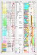 7. Chronostratigraphic
summary of the North West Shelf.
7. Chronostratigraphic
summary of the North West Shelf.  11. Composite map of JP1-JO
isopach map (J20 + J30 sequences) in the Northern Carnarvon
11. Composite map of JP1-JO
isopach map (J20 + J30 sequences) in the Northern Carnarvon  22. Historical summary
(1953-2001) of exploration along the North West Shelf showing by year
22. Historical summary
(1953-2001) of exploration along the North West Shelf showing by year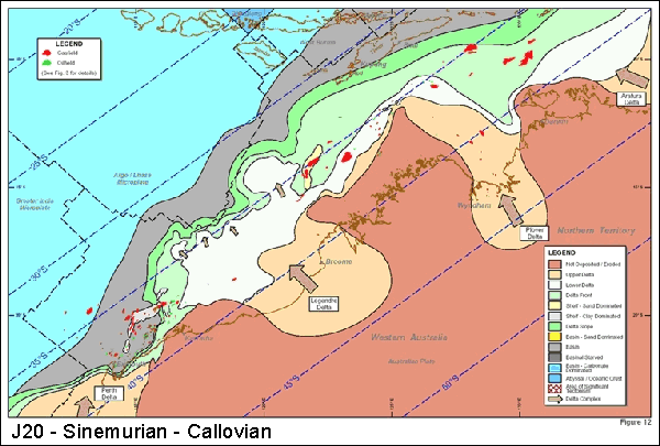
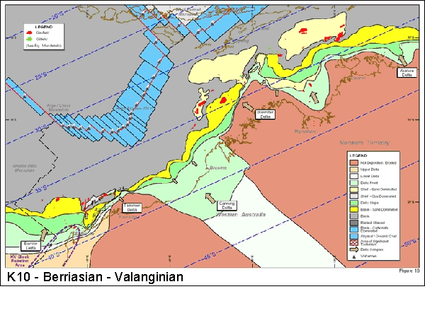
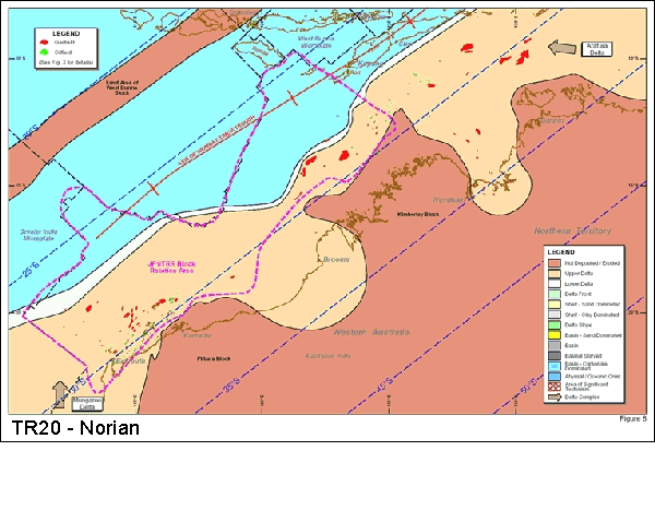
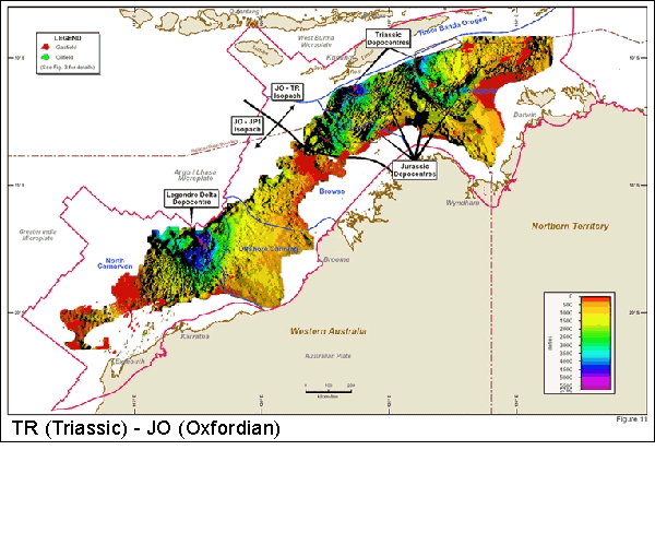