![]() Click to view article in PDF format.
Click to view article in PDF format.
Hydrocarbon Systems Analysis of the Northern Gulf of Mexico: Delineation of Hydrocarbon Migration Pathways Using Seeps and Seismic Imaging*
By
Kenneth C. Hood1, L. M. Wenger2, O. P. Gross3, S.C. Harrison4
Search and Discovery Article #40061 (2002)
* *Adapted for online presentation from article of the same title by the same authors published in AAPG Studies in Geology 48 and SEG Geophysical References Series No. 11, Surface Exploration case Histories: Applications of Geochemistry, Magnetics, and Remote Sensing, D. Schumacher and LA. LeSchack, eds.,p. 25-40. This publication may be purchased from AAPG Bookstore (http://bookstore.aapg.org). Authors performed research and prepared manuscript while employed by Exxon Exploration Company, Houston, Texas, U.S.A.
1-4 Current addresses: 1ExxonMobil Exploration Company, Houston, Texas, U.S.A.; 2ExxonMobil Upstream Research Company, Houston, Texas, U.S.A.; 3Esso Production Malaysia Inc., Kuala Lumpur, Malaysia; 4Consultant, Houston, Texas, U.S.A.
Widespread ![]() oil
oil![]() and gas seepage in
the offshore U.S. Gulf of Mexico has allowed the extension of hydrocarbon
systems and maturity maps far beyond well control. Analysis of sea-bottom
dropcores and imaging of sea-surface slicks have complemented Exxon’s
integrated, multidisciplinary study of sources, maturation, and migration
pathways. Our approach involved development of a regional geologic framework
through interpretation of 2-D and 3-D seismic data, identification and mapping
of potential source intervals, and delineation of likely migration pathways to
reservoirs and seismic-amplitude anomalies. Hydrocarbon compositions from more
than 2000 reservoired oils, 600 reservoired natural gases, and 3000
hydrocarbon-bearing, sea-bottom dropcores help constrain such source-
and gas seepage in
the offshore U.S. Gulf of Mexico has allowed the extension of hydrocarbon
systems and maturity maps far beyond well control. Analysis of sea-bottom
dropcores and imaging of sea-surface slicks have complemented Exxon’s
integrated, multidisciplinary study of sources, maturation, and migration
pathways. Our approach involved development of a regional geologic framework
through interpretation of 2-D and 3-D seismic data, identification and mapping
of potential source intervals, and delineation of likely migration pathways to
reservoirs and seismic-amplitude anomalies. Hydrocarbon compositions from more
than 2000 reservoired oils, 600 reservoired natural gases, and 3000
hydrocarbon-bearing, sea-bottom dropcores help constrain such source-![]() rock
rock![]() characteristics as organic-matter type, depositional facies, level of maturation
and, to some extent, age. East of the Mississippi River Delta, the complete
stratigraphic section is visible on seismic sections, and wells have penetrated
deep source intervals. To the west, correlative organic-rich rocks have been
sampled onshore and from sheaths overlying salt diapirs offshore. Integration of
these data into a regional geologic framework provides a strong basis for
hyrocarbon-systems interpretations.
characteristics as organic-matter type, depositional facies, level of maturation
and, to some extent, age. East of the Mississippi River Delta, the complete
stratigraphic section is visible on seismic sections, and wells have penetrated
deep source intervals. To the west, correlative organic-rich rocks have been
sampled onshore and from sheaths overlying salt diapirs offshore. Integration of
these data into a regional geologic framework provides a strong basis for
hyrocarbon-systems interpretations.
Major offshore hydrocarbon systems
are derived from lower Tertiary (centered on Eocene), Upper Cretaceous (centered
on Turonian), and Upper Jurassic (centered on Tithonian) source intervals. All
Eocene ![]() oil
oil![]() types (marine, intermediate, and terrestrial) have been
tied to source rocks and are consistent with
paleofacies distributions for the Eocene deltaic systems. Eocene oils and gases
are prevalent on the Texas and Louisiana shelves and extend both onshore and
onto the Texas Slope. Turonian oils have been tied to source rocks offshore
(east of the Mississippi River Delta) and onshore (e.g., Tuscaloosa and Giddings
trends). Based on seismic-image thinning of the interval and disappearance of
diagnostic oils, we interpret a basinward loss of this source type.
Elevated-sulfur oils and associated (cogenerated) gases on the upper Gulf of
Mexico Slope are interpreted to have originated from a Tithonian source.
High-maturity, organic-rich calcareous shales of this age have been penetrated
in the eastern Gulf of Mexico, and Tithonian oils occur in Cretaceous reservoirs
on the Florida Shelf where the Upper Cretaceous and Tertiary sections are
immature. Oxfordian carbonate-sourced oils are common across the northern Gulf
basin’s rim, and lower-maturity hydrocarbons from this source occur in stains
and seeps in the deep central Gulf of Mexico.
types (marine, intermediate, and terrestrial) have been
tied to source rocks and are consistent with
paleofacies distributions for the Eocene deltaic systems. Eocene oils and gases
are prevalent on the Texas and Louisiana shelves and extend both onshore and
onto the Texas Slope. Turonian oils have been tied to source rocks offshore
(east of the Mississippi River Delta) and onshore (e.g., Tuscaloosa and Giddings
trends). Based on seismic-image thinning of the interval and disappearance of
diagnostic oils, we interpret a basinward loss of this source type.
Elevated-sulfur oils and associated (cogenerated) gases on the upper Gulf of
Mexico Slope are interpreted to have originated from a Tithonian source.
High-maturity, organic-rich calcareous shales of this age have been penetrated
in the eastern Gulf of Mexico, and Tithonian oils occur in Cretaceous reservoirs
on the Florida Shelf where the Upper Cretaceous and Tertiary sections are
immature. Oxfordian carbonate-sourced oils are common across the northern Gulf
basin’s rim, and lower-maturity hydrocarbons from this source occur in stains
and seeps in the deep central Gulf of Mexico.
Refinements in our understanding of Gulf of Mexico hydrocarbon systems have resulted
from this study. They have helped us to improve our exploration methodologies and have provided us with new play concepts
|
|
Click here for sequence of Figure 2 (hydrocarbon-systems map) and Figure 4 (seep-distribution map).
Table Caption
INTRODUCTIONContinued exploration success in the northern U.S. Gulf of Mexico Basin requires a thorough understanding of all elements of the hydrocarbon systems. To this end, Exxon (now ExxonMobil) has carried out an integrated study to assess sources, maturation, and migration pathways of known and potential hydrocarbon plays in the offshore U.S. Gulf of Mexico. Exxon’s multidisciplinary approach has involved development of a regional geologic framework through the interpretation of 2-D and 3-D seismic data, identification and mapping of potential source intervals, and delineation of likely migration path-ways. This approach permits evaluation of hydrocarbon migration from mature source intervals to known accumulations and potential reservoirs, as identified by seismic-amplitude anomalies.
The recognition of widespread, and often
intense,
APPROACH AND GEOLOGIC FRAMEWORK
The sources for oils reservoired in the
young Tertiary section of the offshore Gulf of Mexico have been
enigmatic in the past, because of a paucity of source-
Geochemical compositions
of reservoired and seep hydrocarbons provide a perspective on the
regional characteristics and maturity of their respective source rocks.
To the east of the present-day Mississippi River Delta, source intervals occur at depths between about 16,000 and 35,000 ft (4900–10,700 m) and are generally visible on seismic sections because of only limited interference by small, simple salt bodies above source levels (Figure 1). In contrast, to the west, the source intervals commonly occur at depths between 30,000 and 45,000+ ft (9200–13,700+ m), and seismic visibility is hampered by the presence of multilayered salt sills and/or salt welds with complex geometries formed by sediment loading. Interpretation of hydrocarbon families and source intervals in this more complex setting was guided by extending westward the observations and methodologies developed in the east and north. Most 2-D seismic surveys designed to image common reservoir intervals are generally inadequate to only marginally adequate for imaging deeper source intervals and migration pathways. These data are typically high (60–75) fold, acquired with 4000–4500 m of cable, and recorded to 8 seconds (s). Dramatic improvements in imaging the total hydrocarbon system are provided by a longer cable (6000 m), 3-D versus 2-D acquisition, and longer recording times (15 s). To date, 3-D data collected using a 6000-m cable have provided some of the best resolution (Gross et al., 1995). We used more than 3500 mi 2 (9100 km 2 ) of 3-D seismic data and 25,000 line-mi (40,250 line-km) of 2-D seismic data within the area east of the Mississippi River Delta, including a 4-mi (6.4-km) grid of 6000-m cable data, recorded to 15 s. A similar amount of seismic data was interpreted to the west of the Mississippi River Delta, on the Louisiana Shelf and Slope and the Texas Slope. GULF OF MEXICO HYDROCARBON SYSTEMS
Knowledge of the effective
source rocks for an area is critical to understanding the overall
hydrocarbon system. Critical source-
Regional differences in
the original organic-matter composition of the lower Tertiary source
appear to explain much of the variation in the resulting hydrocarbon
compositions (distribution of
The next-older source
interval identified is in Upper Cretaceous strata, centered on the
Turonian. Turonian source rocks are clay-rich shales with dominantly
marine organic matter that generates low-sulfur oils (Marine–Low
Sulfur–No Tertiary Influence). Direct
The source for most reservoired
thermogenic hydrocarbons on the Gulf of Mexico Slope is interpreted to
be uppermost Jurassic, centered on the Tithonian. Organic-rich
calcareous shales of Tithonian age have been penetrated and sampled
within wells in the area east of the present Mississippi River Delta.
Although the high maturity level of these shales makes geochemical
Upper Jurassic (Oxfordian)
carbonate-sourced oils (Carbonate–Elevated Salinity–Jurassic
Finally, hydrocarbons from a Triassic
lacustrine source have been encountered along the bounding faults of the
northern Gulf basin. These hydrocarbon liquids display a strong (and
unusual) fermenting bacterial input from the source facies. Although
they are postmature where penetrated, paleontologic and palynologic
analyses of organic-rich Triassic cores from northeast Texas have
confirmed the nonmarine (i.e., the lacustrine) nature of the
depositional environment and have provided a basis for
The four key source intervals in the offshore Gulf of Mexico (centered on lower Tertiary, Upper Cretaceous, Upper Jurassic–Tithonian, and Upper Jurassic–Oxfordian strata) coincide with second-order transgressions in a sequence-stratigraphic framework (Figure 3). Core and cuttings analyses indicate that source richness can vary considerably within an interval, possibly reflecting local or temporal variations in the environment. REMOTE SENSING OF SEA-SURFACE SLICKSRemote-sensing (satellite) techniques are useful screening tools for identifying potential hydrocarbon seepage in a basin (e.g., MacDonald et al., 1993). Various techniques, such as Landsat Thematic Mapper and Synthetic Aperture Radar, can image hydrocarbon slicks remotely on the sea surface. Hydrocarbons on the sea surface often dampen ripples and reduce the reflectivity of water, making slicks appear as darker patterns on the sea surface. Remote-sensing techniques are often expedient because large offshore areas can be screened rapidly and in a cost-effective manner. Application of multiple techniques and/or multitemporal images raises confidence in the interpretation of authentic natural surface slicks. Abundant natural slicks generally indicate an active hydrocarbon system (e.g., MacGregor, 1993; Kornacki et al., 1994) and may provide some evidence of hydrocarbon charge limits.
Slick distributions provide an initial guide to areas that are candidates for site-specific, sea-bottom sediment coring surveys. Numerous factors can affect both the interpretation of authentic seepage and the location of surface slicks relative to source vents on the sea bottom. These factors include wind velocity and direction, currents, cloud cover, meteorologic conditions, marine vegetation, and anthropogenic pollution. After candidate areas have been identified, the next step is to verify the sea-bottom source of the hydrocarbons. High-resolution 2-D and 3-D seismic data, sometimes complemented by side-scan sonar surveys, are used to identify sea-bottom features from which dropcores can be collected. Potential targets include the surface expressions of deep-cutting faults and diapirs, as well as such other water-bottom features as mounds and pockmarks. Many such water-bottom features in the deep-water Gulf of Mexico contain small quantities of hydrocarbons that have migrated from depth. Dropcores collected over targeted water-bottom features are analyzed for the presence and geochemical characteristics of petroleum hydrocarbons.
SEA-BOTTOM HYDROCARBON SEEPS
The Gulf of Mexico Slope
contains widespread areas of
Figure 5 illustrates the intense
hydrocarbon biodegradation that can be encountered in dropcores
collected on the Gulf of Mexico Slope. In this particular example, only
about 5 ft (1.5 m) of sediments was recovered, although most Gulf of
Mexico dropcores recover about 15 ft (4.6 m) of sediment. The limited
penetration likely results from an authigenic carbonate hard-ground
surface formed in response to hydrocarbon seepage. Canned headspace gas
concentrations and whole-extract gas chromatograms (GCs) are shown for
three sections sampled from the core.
All three samples from the dropcore
contained high levels of natural gas and
To evaluate the hydrocarbons in
sea-bottom sediments, the
Seeps can be used to enhance our understanding of several aspects of the hydrocarbon system, including source maturation and migration timing. On the Gulf of Mexico Slope, many large hydrocarbon accumulations have large seeps at the intersection of the cross-stratal migration pathway with the seafloor. For reasons discussed below, we interpret these large seeps to indicate active, ongoing charge from the source rather than trap failure resulting from inadequate seal or structural deformation subsequent to hydrocarbon emplacement. Other authors, including Nunn and Sassen (1986) and Kornacki et al. (1994), have reached similar conclusions about the derivation of hydrocarbons in seeps. Because seeps appear to indicate active migration from the source, they represent a positive indicator of the potential effectiveness of the associated migration pathways. In contrast, if hydrocarbons in seeps resulted from trap failure without active recharge, then large seeps would likely be associated with under-filled or dry structures.
Several lines of evidence support the
interpretation that pervasive seepage on the Gulf of Mexico Slope
results from active hydrocarbon generation and ongoing charge from the
source. First, the apparent volume of seeping hydrocarbons appears to
preclude the possibility that generation occurred in the past and that
hydrocarbons are currently leaking out of known or unidentified deep
reservoirs. For example, MacDonald et al. (1993) estimated that the
volume of hydrocarbons in surface slicks exceeds 120,000 barrels (bbl)
of
Natural seeps contain varying mixtures
of
A small dropcore program was designed to
evaluate the use of seeps as direct indicators of the extent of a field
(Figure 8). A grid of 41 dropcores was extended from presumed
background, across the seismic-amplitude anomalies of a major discovery
on the eastern Gulf of Mexico Slope, and across the interpreted
migration pathway. Background MFI values were recorded in dropcores
represented along the right and upper parts of the figure. Substantially
higher MFI values were recorded near salt features and faults associated
with the likely cross-stratal migration conduit. Fluorescence intensity
generally decreases from right to left, away from cross-stratal
migration pathways. Anomalously high values over the field but away from
the principal cross-stratal migration conduit may suggest migration of
MIGRATION PATHWAY EVALUATIONAn understanding of source intervals, coupled with the ability to image known and potential hydrocarbon accumulations (from seismic-amplitude anomalies), facilitates the evaluation of potential migration pathways within a basin. Most known fields and discoveries in the offshore Gulf of Mexico require cross-stratal migration to move hydrocarbons from known, deep source intervals to young Tertiary reservoirs. The two most likely mechanisms for creating cross-stratal conduits are salt movement and faulting. To be effective, potential migration pathways must intersect both the deep source intervals and the young reservoir levels. In some areas, modern seismic data allow the entire inferred migration pathway to be imaged. In cases where migration pathways extend to the seafloor, sea-bottom hydrocarbon occurrences and surface slicks can be used to document active migration.
In our study area, migration pathways with the fewest segments (individual faults or salt/sediment interfaces) and the greatest disruption between source and reservoir levels appear to be the most effective. Consequently, collapsed salt stocks appear to provide more effective migration conduits than faults do, in areas where both features are present. Vertical salt movement from the Middle Jurassic Louann Salt (autochthonous salt) to allochthonous salt sills within the Tertiary section rovides a strong disruption of the overlying sources and younger strata. The disruption appears to be enhanced when the salt stock pinches off from the mother salt, and the surrounding strata collapse as the salt evacuates. Figure 9 illustrates several potential as well as some unlikely migration pathways on the eastern Gulf of Mexico Slope. Notice how the salt stock on the right part of the seismic line penetrates all potential source intervals and provides a strong focus of hydrocarbons into the cross-stratal conduit. Several seismic-amplitude anomalies shallower in the section appear to connect to this pathway extending below the shallow salt. The large fault on the lower left part of the seismic line also cuts the potential source intervals, but the dip of the source on the downthrown side of the fault appears to provide less migration focus into the cross-stratal conduit in this 2-D view. A somewhat smaller seismic-amplitude anomaly connects to the conduit shallower in the section. Many other shallow faults on this part of the line do not intersect the source intervals and thus would have limited potential as effective migration conduits.
In many areas of the Gulf of Mexico, the source intervals cannot be imaged on seismic sections, making it difficult to evaluate the viability of potential migration pathways. Fortunately, many of the potential migration pathways reach the seafloor and can be evaluated for direct evidence of hydrocarbon migration. Even so, the relationship between seafloor hydrocarbon indicators and hydrocarbon accumulations at depth is complex. Most large hydrocarbon accumulations on the Gulf of Mexico Slope have large seeps at or near the intersection of the cross-stratal migration conduit with the seafloor. However, some migration pathways with large seeps at the seafloor do not have known or inferred hydrocarbon accumulations at depth. Thus, a large seep at the seafloor would be considered a positive indicator of hydrocarbon migration, thereby reducing the risk for an associated seismic-amplitude anomaly, but it would not be considered a definitive indicator of a hydrocarbon accumulation.
Figure 10 illustrates the
interpreted migration pathway for a major discovery on the Gulf of
Mexico Slope. The interpreted collapsed salt stock is labeled
“salt-ascension zone” under the salt body. The collapsed salt stock
appears to be the main conduit connecting the uppermost Jurassic (Tithonian)
source interval to Miocene reservoirs. Figure 11 shows high-resolution,
shallow seismic data across a seafloor mound near the intersection of
the cross-stratal migration
conduit with the sea bottom. The seafloor mound is 200+ ft (60+ m) high
and more than 8000 ft (2500 m) wide. MFI values exceeding 2.5 million
indicate that the mound is a site of substantial CONCLUSIONSAn integrated-study approach to understanding regional source distribution, hydrocarbon maturation levels, and effective migration pathways in the deep-water Gulf of Mexico has resulted in development of new play concepts and has helped to improve Exxon’s exploration strategies.
Major offshore hydrocarbon systems are derived from lower Tertiary (centered on Eocene), Upper Cretaceous (centered on Turonian), and Upper Jurassic (centered on Tithonian) source intervals. Regional variations in source facies result in subfamilies within these hydrocarbon systems. Oxfordian carbonate-sourced oils are common across the northern Gulf basin rim, and lower-maturity hydrocarbons from this source are found in stains and seeps in the deep central Gulf of Mexico.
Satellite-based tools for seep detection
have proved useful for screening large tracts of offshore acreage for
evidence of active hydrocarbon systems in a cost-effective manner.
Piston-core sampling of features imaged on the seafloor has provided
samples of
Analysis of many sea-bottom sediments by such high-resolution techniques as GC/MS and GC/MS/MS has allowed us to place samples within a regional interpretive framework. This framework has enabled us to understand complex signatures that included heavily biodegraded petroleum compounds and the overprint of recent organic matter. The regional framework has allowed estimation of likely characteristics of reservoired oils over virtually the entire offshore Gulf of Mexico.
Integration of seep data with geophysical imaging of source rocks and potential migration pathways, such as diapiric salt and major faults, has improved our understanding of effective migration pathways. This understanding can be used to risk the migration pathways associated with amplitude anomalies, which may represent hydrocarbon accumulations, or any other trap. Potential pathways that provide the greatest disruption and fewest segments between source and reservoir levels (e.g., salt diapirs) appear to provide the most effective migration conduits. The collection of dropcores and analysis of seeps have been major contributors to our current understanding of hydrocarbon migration on the Gulf of Mexico Slope.
ACKNOWLEDGMENTSWe thank Exxon Exploration Company (now Exxon-Mobil) for permission to publish this paper. We would like to acknowledge the contributions of many coworkers in the Gulf of Mexico, and particularly Marilyn Smith for encouraging this publication. We also thank Roger Sassen for many Gulf of Mexico discussions and for permission to use selected analytical data from the Geochemical and Environmental Research Group at Texas A & M University. The paper has benefited from critical reviews by Jerry Atkinson, Flip Koch, Mark Beeunas, Joe Curiale, and Kate Weissenburger. REFERENCES CITED
Brooks, J. M., M. C. Kennicutt, and B. D. Carey, 1986,
Offshore surface geochemical exploration: Brooks, J. M., M. C. Kennicutt, L. A. Barnard, G. J. Denoux, and B. D. Carey, 1983, Application of total scanning fluorescence to exploration geochemistry: Proceedings of the 15th Offshore Technology Conference, Houston, Texas, v. 3, p. 393–400. Connan, J., 1984, Biodegradation of crude oils in reservoirs, in J. Brooks and D. Welte, eds., Advances in Petroleum Geochemistry, v. 1: Academic Press (London) Ltd., p. 299–335. González-García, R., and N. Holguin-Quiñones, 1992, Geology of the source rocks of Mexico: Proceedings of the 13th World Petroleum Congress, v. 2, p. 95–104. Gross, O. P., K. C. Hood, L. M. Wenger, and S. C. Harrison, 1995, Seismic imaging and analysis of source and migration within an integrated hydrocarbon system study: Northern Gulf of Mexico Basin, in First Latin American Geophysical Conference, Rio de Janeiro, 4 p. Haq, B. U., J. Hardenbol, and P. R. Vail, 1988, Mesozoic and Cenozoic chronostratigraphy and cycles of sea-level change, in C. K. Wilgus et al., eds., Sea-level changes: An integrated approach: SEPM Special Publication no. 42, p. 71–108. James, A. T., L. M. Wenger, M. B. Melia, A. H. Ross, and C. P. Kuminez, 1993, Recognition of a new hydrocarbon play in a mature exploration area through integration of geochemical, palynologic, geologic, and seismic interpretations (onshore northern Gulf of Mexico): Program with Abstracts, 1993 AAPG Annual Meeting, New Orleans, Louisiana, U.S.A., p. 123.
Kornacki, A. S., J. W. Kendrick, and J. L. Berry, 1994,
Impact of
Lawrence, D. T., and R. N. Anderson, 1993, Details
confirm Gulf of Mexico deepwater as significant province:
MacDonald. I. R., J. F. Reilly Jr., S. E. Best, R.
Venkataramaiah, R. Sassen, N.L. Guinasso, and J. F. Amos, 1996, Remote
sensing inventory of active chemosynthetic communities in the northern Gulf of Mexico, in D. Schumacher and M. A. Abrams, eds., Hydrocarbon migration and its near-surface expression: AAPG Memoir 66, p. 27–37.
MacDonald, I. R., N. L. Guinasso, S. G. Ackleson, J. F.
Amos, R. Duckworth, R. Sassen, and J. M. Brooks, 1993, Natural MacGregor, D. S., 1993, A new look at an old tool: The exploration significance of surface seeps: AAPG Bulletin, v. 77, p. 1644. McDade, E. C., R. Sassen, L. M. Wenger, and G. A. Cole, 1993, Identification of organic-rich Lower Tertiary shales as petroleum source rocks, south Louisiana: Gulf Coast Association of Geological Societies Transactions, v. 43, p. 257–267. Nunn, J. A., and R. Sassen, 1986, The framework of hydrocarbon generation and migration, Gulf of Mexico Slope: Gulf Coast Association of Geological Societies Transactions, v. 36, p. 257–262.
Oehler, J. H, 1984, Carbonate source rocks in the
Jurassic Smackover trend of Mississippi, Alabama, and Florida, in
J. G. Palacas, ed., Petroleum geochemistry and source Peters, K. E., and J. M. Moldowan, 1993, The biomarker guide: Englewood Cliffs, New Jersey, Prentice-Hall, 363 p. Rice, D. D, 1993, Biogenic gas: Controls, habitats, and resource potential: USGS Professional Paper 1570, p. 58–606.
Schumacher, D., and R. M. Parker, 1990, Possible
pre-Jurassic origin for some Jurassic-reservoired Thompson, K. F. M., M. C. Kennicutt II, and J. M. Brooks, 1990, Classification of offshore Gulf of Mexico oils and gas condensates: AAPG Bulletin, v. 74, p. 187–198.
Wagner, B. E., Z. Sofer, and B. L. Claxton, 1994, Source
Wenger, L. M., L. R. Goodoff, O. P. Gross, S. C. Harrison, and K. C. Hood, 1994, Northern Gulf of Mexico: An integrated approach to source, maturation, and migration, in N. Scheidermann, P. Cruz, and R. Sanchez, eds., Geologic aspects of petroleum systems: First Joint AAPG-AMGP Hedberg Research Conference, 5 p. Wenger, L. M., R. Sassen, and D. Schumacher, 1990, Molecular characteristics of Smackover, Tuscaloosa and Wilcox reservoired oils in the eastern Gulf Coast, in D. Schumacher, ed., Geochemistry of Gulf Coast oils and gases: Gulf Coast Section SEPM Foundation Ninth Research Conference, p. 37–57. |
 Figure
3. Stratigraphic column showing the Mesozoic source intervals (arrows)
for the offshore Gulf of Mexico. Note that source intervals coincide
with second-order transgressions in a sequence-stratigraphic framework
(e.g., Haq et al., 1988).
Figure
3. Stratigraphic column showing the Mesozoic source intervals (arrows)
for the offshore Gulf of Mexico. Note that source intervals coincide
with second-order transgressions in a sequence-stratigraphic framework
(e.g., Haq et al., 1988). Figure
5. Example of a biodegradation profile within a single sea-bottom
dropcore from Ewing Banks. Total depth of the core is about 5 ft (1.5
m).
Figure
5. Example of a biodegradation profile within a single sea-bottom
dropcore from Ewing Banks. Total depth of the core is about 5 ft (1.5
m). Figure
6. Comparison of deepest
Figure
6. Comparison of deepest 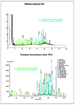 Figure
7. Whole-
Figure
7. Whole- Figure
8. Sea-bottom dropcore grid within Viosca Knoll, designed to evaluate
the utility of seeps for defining the limit of field extent as indicated
by seismic-amplitude anomalies (shaded area).
Figure
8. Sea-bottom dropcore grid within Viosca Knoll, designed to evaluate
the utility of seeps for defining the limit of field extent as indicated
by seismic-amplitude anomalies (shaded area). Figure
9. Example of a seismic line showing the source intervals and several
potential hydrocarbon migration pathways (compliments of Veritas Marine
Services).
Figure
9. Example of a seismic line showing the source intervals and several
potential hydrocarbon migration pathways (compliments of Veritas Marine
Services). Figure
10. Example of a seismic line showing the interpreted cross-stratal
migration pathway to a large discovery in the southern Mississippi
Canyon.
Figure
10. Example of a seismic line showing the interpreted cross-stratal
migration pathway to a large discovery in the southern Mississippi
Canyon. Figure
11. Example of a seismic line showing a close-up of a seafloor mound
interpreted to represent a chemosynthetic community over the cross-stratal
migration pathway illustrated in
Figure
11. Example of a seismic line showing a close-up of a seafloor mound
interpreted to represent a chemosynthetic community over the cross-stratal
migration pathway illustrated in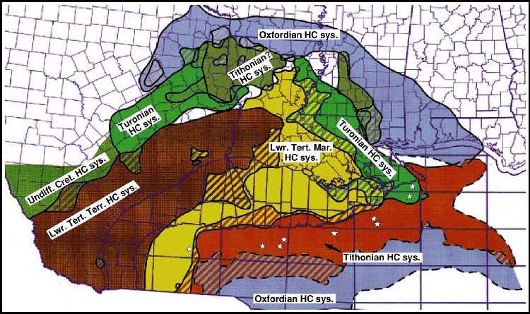