The following companies have sponsored the posting of this article:


![]() Click
to view article in PDF format.
Click
to view article in PDF format.
GIS in an Overview of Iraq ![]() Petroleum
Petroleum![]() Geology
Geology
By
Jingyao Gong1 and Larry Gerken2
Search and Discovery Article #10041 (2003)
1AAPG, Tulsa, OK, USA ([email protected])
2Newfield Exploration Company, Tulsa, OK, USA ([email protected])
Georeferenced maps of Iraq, almost entirely from AAPG
publications, are presented herein to show the overall framework of this country
within a region that contains vast ![]() petroleum
petroleum![]() resources and to show some features
of representative fields. Several maps of fields are accompanied by
cross-sections; correlation diagrams for Northern and Southern Iraq are
presented along with a tabulation of the various producing stratigraphic units.
For presentation, each map utilizes the geographic coordinate system wherein
each increment of latitude and longitude is equal.*
resources and to show some features
of representative fields. Several maps of fields are accompanied by
cross-sections; correlation diagrams for Northern and Southern Iraq are
presented along with a tabulation of the various producing stratigraphic units.
For presentation, each map utilizes the geographic coordinate system wherein
each increment of latitude and longitude is equal.*
An additional item that is presented in this preliminary compilation is a database of giant fields in Iraq, from the comprehensive databases of giant fields compiled by M.K. Horn to be incorporated in the soon-to-be-published AAPG Memoir, Giant Oil and Gas Fields of the Decade 1990-1999.
.
*Maps presented herein are available in ARCview, from AAPG online bookstore (http://bookstore.aapg.org). They are accompanied by the other illustrations (in PDF format), with appropriate links.
.
|
|
Click to view sequence of cross sections.
Click to view sequence of structure maps.
Click to view sequence of cross sections.
Geologic ConsiderationsIraq is part
of the Zagros and Arabian sedimentary provinces, according to St. John et
al. (1984) (Figure 1). The former is a
folded belt, related to A-subduction; and the Arabian province is a
foredeep, in which the ramp has buried grabens, but with little
blockfaulting (St. John et al., 1984). Fields are present in both
provinces (Figures 2,
3, and 4).
Konert et al. (2001) consider the foredeep in front of
the Zagros (Figures 5 and
6) as a part of a very widespread stable platform. Versfelt (2001)
shows the Zagros ãForeland Basinä to flank the the Zagros mountain front
from the northeast-trending Khleissia high in the north to Hormuz in the
south (Figure 6). The Zagros
sedimentary province includes the Kirkuk (Sirwan) embayment, Lurestan,
Dezful Embayment (Khuzestan), and Fars, the last three being predominantly
in Reservoirs
range in age from Miocene to Triassic. Paleozoic Both carbonates and sandstones are well represented as reservoir rocks. Sandstones are commonly more significant as reservoirs outside the main part of the Zagros province, whereas carbonates are dominant in the main part of the Zagros. Miocene-Oligocene-Eocene are most likely to be productive southwest of the ãmountain frontä (Versfelt, 2001), where the Miocene evaporite (seal) is preserved (Figure 6). Source rocks have been identified in the Eocene-Paleocene, Upper Cretaceous, Mid- to Lower Cretaceous, Upper Jurassic, Middle Jurassic, and Triassic (Versfelt, 2001). Silurian source rock has been documented in western/northwestern Iraq (Konert et al., 2001).
As shown in
the database of giant fields of Iraq (Table 1) (M.K. Horn, 2003), there
are 28 giant fields in Iraq; 27 are classified as oil fields. Discovered
in 1953, the largest field is Rumaila (Figure 15),
9th largest in the world (3rd largest oil field)
with 22 BOE. It is in Southern Iraq and the Arabian sedimentary province.
Kirkuk (Figures 8 and
9), the second largest Iraqi field with 17 BOE, is in Northern Iraq
and the Zagros province. Discovered in 1927, it is the 17th
largest field (8th largest oil field) in the world. Ultimate
recovery from the giant fields of Iraq is estimated to be 85 BOE; for
comparison, the estimate for North Dome Gas Field in Qatar is 160 BOE, and
97 BOE for Ghawar Oil Field in Saudi Arabia. Remaining recovery, or
reserves, for the Iraqi giant fields is estimated to be 41 BOE (Horn,
2003), or
approximately one-half of the ultimate recovery. More than a decade ago,
ultimate recoverable
Al Shdidi, Saad, Gerard Thomas, and Jean Delfaud, 1995, Sedimentology, diagenesis, and oil habitat of Lower Cretaceous Qamchuqa Group, Northern Iraq: AAPG Bulletin , v. 79, p. 763-778. Beydoun. Z. R., 1991, SG 33: Arabian Plate Hydrocarbon Geology and Potential--A Plate Tectonic Approach: AAPG Studies in Geology #33, 77p.
Carmalt, S.W.,
and Bill St. John, 1986, Giant oil and gas fields, in Future
El Zarka, Mohamed Hossny, Ain
Zalah Field--Iraq Zagros folded zone, Northern Iraq, in Structural
Traps VIII, AAPG Treatise of
Halbouty, Michel T., A.A. Meyerhoff, Robert E. King, Robert
H. Dott, Sr, H. Douglas Klemme, and Theodore Shabad, 1970, World's giant
oil and gas fields, geologic factors affecting their formation, and basin
classification: Part I: Giant oil and gas fields, in Geology of
Giant Horn, M.K., 2003, Giant fields, 1868-2003 (databases), in Giant Oil and Gas Field of the Decade 1990-1999, AAPG Memoir (in press).
Ibrahim, M.W., 1983,
Konert, G., A.M. Afifi, S.A. Al-Hajri,
K. de Groot, A.A. Al Naim, and H.J.Droste, Paleozoic stratigraphy and
hydrocarbon habitat of the Arabian Plate, in Majid, A. Hamid, and Jan Veizer, 1986, Deposition and chemical diagenesis of Tertiary carbonates, Kirkuk oil field, Iraq: AAPG Bulletin, v. 70, p. 898-913. St. John, Bill, A.W. Bally, H.Douglas Klemme, 1984, Sedimentary provinces of the world÷hydrocarbon productive and nonproductive: AAPG. map and booklet (35 p.).
Versfelt, Porter, L., Jr., 2001, Major hydrocarbon
potential in
|
 Figure
1. Sedimentary provinces of much of Europe, Africa, and Asia, centered on
the Zagros (folded belt) and Arabian (foredeep) provinces (from St. John et al., 1984).
Figure
1. Sedimentary provinces of much of Europe, Africa, and Asia, centered on
the Zagros (folded belt) and Arabian (foredeep) provinces (from St. John et al., 1984). Figure
2. Fields and discoveries (as of 1990) of the Arabian Plate (from Beydoun,
1991).
Figure
2. Fields and discoveries (as of 1990) of the Arabian Plate (from Beydoun,
1991). Figure
3. Enlargement of
Figure
3. Enlargement of Figure
4. Tectonic elements of the Arabian Plate and
Figure
4. Tectonic elements of the Arabian Plate and  Figure
6. Key structural elements in the Zagros province, with oil and gas fields
(from Versfelt, 2001).
Figure
6. Key structural elements in the Zagros province, with oil and gas fields
(from Versfelt, 2001). Figure
8. Structural sketch map of Kirkuk field, Northern Iraq (after Dunnington,
1958; Majid and Veizer, 1986).
Figure
8. Structural sketch map of Kirkuk field, Northern Iraq (after Dunnington,
1958; Majid and Veizer, 1986). Figure
9. Schematic cross-sections of Kirkuk area, illustrating accumulations in
Baba dome and Bai Hassan field (after Dunnington, 1958).
Figure
9. Schematic cross-sections of Kirkuk area, illustrating accumulations in
Baba dome and Bai Hassan field (after Dunnington, 1958).  Figure
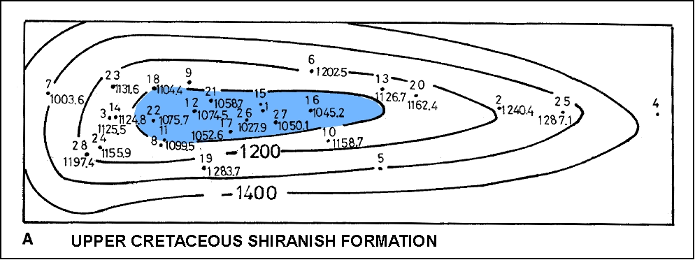
10. Structure maps, Ain Zalah (from El Zarka 1993). A on top of upper
Upper Cretaceous Shiranish Formation. B on top of Upper Cretaceouos
Mashurah Formation. C on top of Lower Cretaceous Qamchuqa Formation.
Figure
10. Structure maps, Ain Zalah (from El Zarka 1993). A on top of upper
Upper Cretaceous Shiranish Formation. B on top of Upper Cretaceouos
Mashurah Formation. C on top of Lower Cretaceous Qamchuqa Formation.  Figure
11. Cross section of Ain Zalah field (after Dunnington, 1958).
Figure
11. Cross section of Ain Zalah field (after Dunnington, 1958). Figure
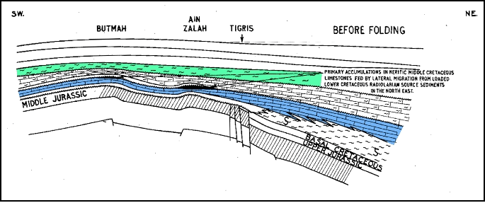
12. Schematic cross-sections of Ain Zalah area, showing the entrapment of
oil in Ain Zalah and Butmah fields (after Dunnington, 1958).
Figure
12. Schematic cross-sections of Ain Zalah area, showing the entrapment of
oil in Ain Zalah and Butmah fields (after Dunnington, 1958).  Figure
13. Schematic structural map and cross section of fields in the Qaiyarah
area, showing two superposed accumulations. Both show tilted oil-water
contacts. (After Dunnington, 1958).
Figure
13. Schematic structural map and cross section of fields in the Qaiyarah
area, showing two superposed accumulations. Both show tilted oil-water
contacts. (After Dunnington, 1958). Figure
14. Stratigraphic column, Permian-Pleistocene, Northern Iraq (after Al
Shdidi et al., 1995).
Figure
14. Stratigraphic column, Permian-Pleistocene, Northern Iraq (after Al
Shdidi et al., 1995). Figure
15. Schematic structure map of Rumaila, Tuba, and Zubair fields, Southern
Iraq, on Lower Cretaceous Zubair sandstone.
Figure
15. Schematic structure map of Rumaila, Tuba, and Zubair fields, Southern
Iraq, on Lower Cretaceous Zubair sandstone.
![Database of giant fields in Iraq, showing basic geologic features and estimates of ultimate recovery and reserves (from Horn, 2003 [with minor revision]).](images/tab01.jpg)