![]() Click to view page images in PDF format.
Click to view page images in PDF format.
Jeremy J. Zimmerman1
Search and Discovery Article #40023 (2001)
1Nuevo Energy Company, Houston, TX ([email protected]).
*Adapted
for online presentation from article entitled “It’s All a Matter of Space
and ![]() Time
Time![]() ” by the same author in Geophysical Corner, AAPG
Explorer, December, 1996. Appreciation is expressed to the author and to M.
Ray Thomasson, former Chairman of the AAPG Geophysical Integration Committee,
and Larry Nation, AAPG Communications Director, for their support of this online
version.
” by the same author in Geophysical Corner, AAPG
Explorer, December, 1996. Appreciation is expressed to the author and to M.
Ray Thomasson, former Chairman of the AAPG Geophysical Integration Committee,
and Larry Nation, AAPG Communications Director, for their support of this online
version.
Most geoscientists in
the petroleum industry are dealing with the problem that seismic information is
usually displayed in some form of a ![]() time
time![]() section, be it a
section, be it a ![]() time
time![]() stack section or
a
stack section or
a ![]() time
time![]() -migrated section. Drillers, engineers, geologists, geophysicists, and
earth scientists in general describe the earth in depth, as in “x” number of
feet to target, “x” number of feet of oil column, etc. How do you get easily
from
-migrated section. Drillers, engineers, geologists, geophysicists, and
earth scientists in general describe the earth in depth, as in “x” number of
feet to target, “x” number of feet of oil column, etc. How do you get easily
from ![]() time
time![]() to depth? The answer depends on the desired level of complexity, which
is usually dictated by how soon something is needed or how much it will cost.
to depth? The answer depends on the desired level of complexity, which
is usually dictated by how soon something is needed or how much it will cost.
The overall process is
called depth conversion, although some prefer to be more rigorous and call it
depth ![]() migration
migration![]() . The simplest definition of depth conversion is the conversion
of some measurable
. The simplest definition of depth conversion is the conversion
of some measurable ![]() time
time![]() quantity into some understandable value in depth. The
old joke of when someone asks how deep is the well and the junior geoscientist
responds that “it’s about three seconds ...” pops into many people’s
minds when dealing with representations of well progress with respect to a
chosen seismic section. So just how do we convert from
quantity into some understandable value in depth. The
old joke of when someone asks how deep is the well and the junior geoscientist
responds that “it’s about three seconds ...” pops into many people’s
minds when dealing with representations of well progress with respect to a
chosen seismic section. So just how do we convert from ![]() time
time![]() to depth?
to depth?
The purpose of this
article is to introduce geoscientists to some basic ideas about depth conversion
as well as give examples of when it is appropriate to use a given method. It is
not meant to be a rigorous dissertation of depth ![]() migration
migration![]() .
.
|
|
Click here for sequence of Figures 3 and 7.
Click here for sequence of Figures 4 and 5.
Click here for sequence of Figures 4 and 5.
Click here for sequence of Figures 3 and 7. The
raypath concept is the keystone to seismic exploration. The assumption
that an expanding wavefront (analogous to the expanding circle that is
produced when a rock is dropped in water) can be simulated by a collection
of raypaths that are traveling perpendicular to the wavefront, is the
basis of seismic modeling and travel- Most
seismic-modeling packages, whether they are two-dimensional (2-D) or
three-dimensional ( A
seismic source imparts energy into the ground, sending waves of energy
down into the subsurface, where some of the energy is reflected, some of
it is transmitted and some portion is lost as attenuation. That part which
is reflected is measured or detected by geophones (land) or hydrophones
(marine). A seismic section is a measure of the amount of energy that is
reflected back to the location of the geophone/hydrophone with respect to
the Typically, rays are easily influenced by the medium in which they travel. The characteristic that is of greatest concern to the geoscientist is the velocity of the different layers through which the rays travel. When seismic energy encounters a medium of different velocity from the one in which it is traveling, it is deflected in accordance with the velocity change, as shown in Figure 2. If the new medium is higher velocity, the energy – and therefore, the raypath – is bent more away from vertical. If the new medium is a lower velocity, the seismic energy is deflected to more nearly vertical. The
first type of section (and most often ignored by much of the petroleum
industry) is the The
second type of section (and the one most often used by the petroleum
industry) is the Upon
seeing a If
dips on events exceed 10o and the velocity field is
“well-behaved,” then depth conversion becomes a little more
complicated. The idea that vertical travel times taken from even a
If
the subsurface reflectors exhibit no dip, then this is a valid assumption.
Otherwise, the endpoint at depth for the vertical raypath and the actual
raypath for the Snell’s
law tells us that small changes in dip and velocity can cause the raypath
to refract. To best compensate for this change in raypath direction, depth
The
example shown here is only in two dimensions. A method for creating depth
models based on ray displacements in three dimensions is called map
Many
map Depth
|
 Figure
2: Elements of Snell’s Law.
Figure
2: Elements of Snell’s Law. Figure
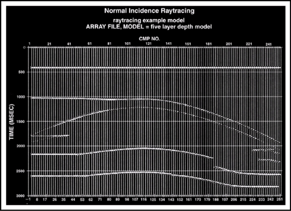
4: Normal–incidence (
Figure
4: Normal–incidence ( Figure
5:
Figure
5:  Figure
6. Raypath endpoints for tme-stack,
Figure
6. Raypath endpoints for tme-stack, 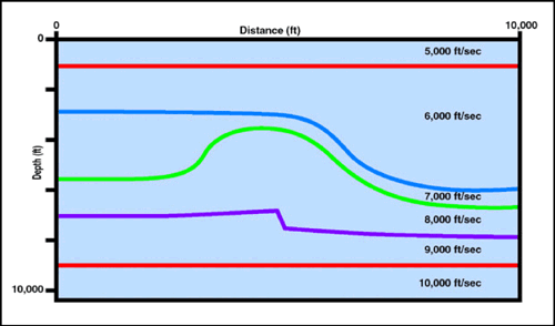