![]() Click to view images of illustrations in PDF format.
Click to view images of illustrations in PDF format.
SEISMIC RESOLUTION: A KEY ELEMENT*
By
Search and Discovery Article #40036 (2001)
*Adapted for online presentation from article of the same title by the same author in Geophysical Corner, AAPG Explorer, October, 1997. Appreciation is expressed to the author and to M. Ray Thomasson, former Chairman of the AAPG Geophysical Integration Committee, and Larry Nation, AAPG Communications Director, for their support of this online version.
1University of Houston, Houston, Texas ([email protected]).
|
|
Click here for sequence of Figure 2A (F-37) and 2B (F-39).
Click here for sequence of Figure 3A and 3B. Click here for sequence of Figure 3C and 3D.
“Resolution
is the ability to separate two features that are very close together; the
minimum separation of two bodies before their individual identities are lost”
( If we consider two similar features (Figure 1), the measurable anomalies that they produce may show as separate, distinguishable anomalies when the two features are well separated – a condition we call “resolved.” When they are close together, however, their effects merge and it is impossible (or at least difficult) to tell that two rather than just one feature is present – and this is a condition we call “unresolved.” The problems of resolution are to determine how (and where) to separate resolved from unresolved domains. Resolution considerations are clearly important in all geologic measurements. How much distance has to separate two anticlines to make it clear that there are two? How far apart must two faults be to recognize that there are two faults? Clearly the data sampling interval is a factor in answering the question (but we shall not delve into this aspect here). The practical problem of resolution has subjective aspects – geologists experienced in looking for subtleties may find clues that tell them that more than one feature is responsible for a given anomaly, whereas inexperienced geologists may not notice the significant aspects. The amount of background noise and other factors also are important in resolution. Resolution also depends on the magnitude of features – they are less resolvable if too weak. To quantify the separation of resolved from unresolved domains, mathematical criteria have to be set; yet, different criteria in the literature lead to different definitions of “resolvable limit.” The first definition by Lord Rayleigh with respect to optical resolution is also the most useful and does not differ by very much from other definitions. In seismic work one usually distinguishes between vertical and horizontal resolution. Vertical resolution concerns the minimum thickness of a bed, so that reflections from the bed’s top and base can be distinguished – that is, so that one can distinguish between a bed of finite thickness from a single reflecting interface. The Rayleigh limit of resolution is that the bed thickness must be 1/4 of the dominant wavelength. This is also the thickness where interpretation criteria change. Measuring the thickness of a bed that is thicker than the Rayleigh limit has to be based on features of the waveshape, whereas for one that is thinner it has to be based on amplitude measurements. Waveshape distortions in the latter case also mean that traveltime measurements to determine bed depth will be in error. To improve the vertical resolution one must shorten the wavelet shape; this requires higher frequencies or shorter wavelength. In passing through the earth a seismic wavelet becomes longer and broader, the shorter wavelengths being attenuated more than the longer ones. Deconvolution is the seismic processing operation that is designed to remove some of the effects of the natural filtering and to produce a shorter wavelet with a waveshape that is easier to interpret. Creating shorter wavelengths improves resolution. In some cases frequency filtering to remove low-frequency components can help, and occasionally one removes the high-frequency components so that one can determine thickness from amplitude measurements. Horizontal
resolution of unmigrated seismic data is often taken as the Fresnel zone
dimensions (
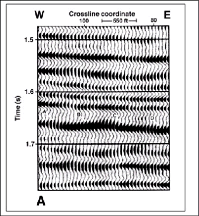
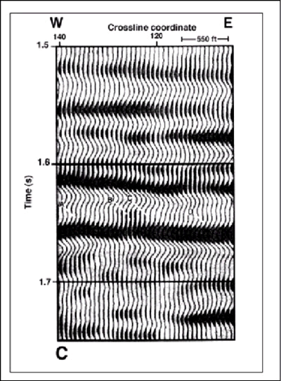
The stratigraphic situation illustrated in Figure 2 is taken from some South Texas studies by the Bureau of Economic Geology (supported by the Gas Research Institute and the U.S. Department of Energy). In Figure 2, a succession of channels, which are commonly productive, lie on top of each other. The different channels are isolated from each other so that each is a separate reservoir. This is clear from production records as the different channel reservoirs have different pressure histories. The evidence of the stacked channels blends together to create a single low frequency reflection that wanders up and down across the section depending on which of the stacked channels is present at a given location. The resolution problem is one of separating the effects of the different channels. Figure 3 shows reflection F-11, which appears to be relatively uniform over the entire area and unaffected by the channels shown as F-37 and F-39, which meandered over the area. It is assumed that the F-11 reflector indicates the surface of the earth at the time of deposition and that, except for overall subsidence, the surface did not change very much between F-11 and the time of the productive channels (F-37 and F-39). Thus, after we flatten data on F-11, any slices through the 3-D volume of seismic data parallel to F-11 but displaced below it represent surfaces of the earth at times earlier than F-11 time. A display of such data is called a horizon slice. Horizon slices are used to remove the effects of deformation subsequent to deposition. This area was subjected to both faulting and tilting since deposition, but these effects have been largely removed by the horizon slicing process. Figure 2 shows the F-37 and F-39 horizon slices that are spaced only 4 ms (0.004 seconds) apart. These two horizon slices show different features, especially the channels in the lower right but also elsewhere. The vertical distance equivalent to 4 ms is about 16 feet, which is near the quarter-wavelength criterion.. Figure 3 shows portions of two east-west lines across the channel shown in the lower right quadrant of Figure 2. It would be very difficult to separate the channel features on the vertical sections, as the interpreted sections in Figure 3 illustrate, but the coherence of the successive horizon slices clearly indicates that different features are being separated in this interpretation. Spatial sampling is clearly a factor in horizontal resolution. Generally the same criteria are used for spatial sampling as for temporal sampling. To some extent there is an interplay between spatial and temporal sampling, and this interplay is currently a subject of study.
|
 Figure 2.
Horizon slices that are separated by 4 ms begin to show different features (from
Tertiary of South Texas).
Figure 2.
Horizon slices that are separated by 4 ms begin to show different features (from
Tertiary of South Texas). Figure 3.
Uninterpreted and interpreted versions of two east-west lines across the channel
features shown in the lower right quadrant of
Figure 3.
Uninterpreted and interpreted versions of two east-west lines across the channel
features shown in the lower right quadrant of