![]() Click to view images of illustrations in PDF format.
Click to view images of illustrations in PDF format.
By Brian S. Anderson1, Mark E. Weber1, and John E. Bain2
Search and Discovery Article #40035 (2001)
1Fugro - LCT Inc., Houston, Texas ([email protected]) ([email protected])
2Galileo Geophysics Inc., Houston, Texas ([email protected])
Adapted
for online presentation from two articles by same authors, entitled
“![]() Gravity
Gravity![]() /Magnetic Data Use Surges” in Geophysical Corner, AAPG Explorer, February, 1998, and “Integration: A Practical
View” in Geophysical Corner, AAPG
Explorer, March, 1998. Appreciation is expressed to the authors and to M.
Ray Thomasson, former Chairman of the AAPG Geophysical Integration Committee,
and Larry Nation, AAPG Communications Director, for their support of this online
version.
/Magnetic Data Use Surges” in Geophysical Corner, AAPG Explorer, February, 1998, and “Integration: A Practical
View” in Geophysical Corner, AAPG
Explorer, March, 1998. Appreciation is expressed to the authors and to M.
Ray Thomasson, former Chairman of the AAPG Geophysical Integration Committee,
and Larry Nation, AAPG Communications Director, for their support of this online
version.
General Statement
Fifty
percent of the world’s seismic fleet is now recording ![]() gravity
gravity![]() and/or magnetic
data – representing a 100 percent increase over just two years ago.
and/or magnetic
data – representing a 100 percent increase over just two years ago.
As
answer to the question of what this remarkable increase represents, the ongoing
surge in use of ![]() gravity
gravity![]() to the present historic high levels can be attributed to
several recent key developments, including:
to the present historic high levels can be attributed to
several recent key developments, including:
·
The industry is involved in more
challenging ![]() exploration
exploration![]() plays than ever before.
plays than ever before.
·
Increased costs of ![]() exploration
exploration![]() and
drilling.
and
drilling.
· Major advances in data resolution.
·
Three-D modeling software applications
are now integrating seismic, ![]() gravity
gravity![]() and magnetics on the same workstation.
and magnetics on the same workstation.
· Three-D seismic has not answered all our questions.
·
Cost-effectiveness of the ![]() gravity
gravity![]() and
magnetic techniques.
and
magnetic techniques.
|
uPractical View of Integration uTeam-Oriented
uPractical View of Integration uTeam-Oriented
uPractical View of Integration uTeam-Oriented
uPractical View of Integration uTeam-Oriented
uPractical View of Integration uTeam-Oriented
uPractical View of Integration uTeam-Oriented
uPractical View of Integration uTeam-Oriented
|
Click here for sequence of Figures 7 and 8.
Click here for sequence of Figures 7 and 8.
Recent AdvancesHistorically,
If
the results of the At
a recent technical meeting in Houston, Ed Biegert, non-seismic methods
specialist for Shell, asked the question: “Why do we re-acquire
Recent
advances in
With these advances, industry has seen stunning improvements over data recorded as recently as 10 years ago. In many cases, there is an increase of up to 10 times the data per unit area in new surveys over older data, with a correspondingly higher level of confidence in interpreted geological results. Many
operators are routinely incorporating new high resolution One
very experienced oil company 1.
Sidney Schafer Water Bottom 2. Legacy Deep Water Marine Data (over 10 years old) over 10,000-foot horizontal distances: 0.5 to 1.0 mGal. 3. New High-Resolution Deep Water Marine Data (1991 or newer), over 1,500-to 3,000-foot horizontal distances: 0.1 to 0.5 mGal. The above examples are general estimates based on several criteria, including positioning, instrumentation, sampling, processing techniques and associated bathymetry accuracy. Recent work has shown that errors of 0.3 to 1.0 mGal or greater can be introduced into data due to use of incorrect water depth or positioning information. The
importance of data resolution makes a thorough investigation of the
Not
many of us have a good grasp of what this measurement unit of The
following is an exercise in converting Modeled
salt thickness
vs. Using
a generalized density vs. depth curve for the deep water Gulf of Mexico,
a series of sensitivity models have been constructed for a salt
lens, two miles in diameter (Figure 3). The salt was inserted into the
density model at several depths. At each depth the thickness was varied
to establish data points for a salt burial depth and thickness vs.
Admittedly,
this is an over-simplified example, but it is effective in demonstrating
the need for good quality For
0.2 mGal data this range grows up to 400 feet; for 0.5 mGal data results
are plus or minus 1000 feet. For 1.0 mGal New
high resolution In terms of new data acquisition, crew and equipment costs are in the range of $1,500 per day or less. In areas like the deep water Gulf, many companies are finding this a worthwhile investment. When rig rates are pushing well over $100,000 per day, it is easy to understand why. Practical View of Integration MethodsEven with the best quality 3-D seismic
data, an interpreter can have a troublesome task in defining the
salt/sediment boundary at the flanks of a salt dome, salt sheet or other
complex structure. For decades,
By incorporating a co-recorded data set
with each data set (e.g., seismic and With the trend toward highly focused
In using a new software tool kit,
high-resolution 1. High-resolution 2. The seismic velocity data are used to create a corresponding density section (or volume, in the 3-D case) by means of a flexible velocity-density conversion tool kit, incorporating: Gardner’s Equation. Nafe/Drake, Hilterman and other density-velocity relationships. Use of available empirical data (e.g. velocity logs, check shot surveys, gamma-gamma density logs, etc.). User defined conversion algorithms or formulae. Other approaches. 3. The density model can be as simple or as elaborate as the corresponding velocity model – up to and including a discrete value of density for each x-y-z node within the profile or volume of data. 4. Input of digital horizon data (again, 2-D or 3-D) as interpreted on the seismic workstation. The system incorporates a “universal translator” for the conversion of one type of horizon to another to accommodate company partner teams, etc. 5. Computation of the 6. Manipulation of the model using both
forward modeling and inversion processes based on minimizing the misfits
between model and measured 7. On completion of the modeling and/or inversion process, the revised earth model is converted into the velocity domain, providing an improved starting point velocity model for depth migration. 8. This iterative process and feedback loop continues throughout the seismic migration and interpretation process. Figure 7 is a cross section through a full three dimensional model of a salt feature in the Gulf of Mexico. The density cube is derived from available well control. The top of salt is typically obtained from a simple initial stretch to depth from the time interpretation. Later--in the interpretive processing sequence--this is updated with the post-stack or pre-stack depth migration results. The base of salt is input from an initial
time interpretation. In many cases the initial base of salt
interpretation is provided with confidence factors; e.g., a 10 might be
assigned to high seismic confidence areas, a 0 being assigned to seismic
blind zones, and grades in between. The The density and velocity data are analyzed,
typically using cross plots, and a function is derived to convert
between the density and the velocity volumes. The Once the final density model is
constructed, the density-velocity function is used to translate the
alterations into an apparent velocity cube. Figure 8 is the final result
of this process. Note the original outline of the salt body (prior to
integration of the A full 3-D view of an integrated
seismic- In today’s team-oriented
To be most effective, the integration of
|
 Figure 6--Flow diagram for integrated seismic-
 Figure 9--Full integration: Incorporated into this Gulf of Mexico
interpretation are a 3-D seismic volume, 3-D velocity volume, 3-D
density volume, calculated and observed
Figure 9--Full integration: Incorporated into this Gulf of Mexico
interpretation are a 3-D seismic volume, 3-D velocity volume, 3-D
density volume, calculated and observed 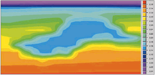