|
Figure Captions (1-6)
 Figure 1. Index map of offshore
Louisiana, showing location of Main Pass (MP) blocks 122/133 area, Bay
Marchand Field (BM), Eugene Island (EI) Block 330 Field, and South
Marsh Island (SMI) Block 130 Field. Figure 1. Index map of offshore
Louisiana, showing location of Main Pass (MP) blocks 122/133 area, Bay
Marchand Field (BM), Eugene Island (EI) Block 330 Field, and South
Marsh Island (SMI) Block 130 Field.
 Figure 2.
The first of two seismic lines in Main Pass
122/133 area, offshore Louisiana, showing strong seismic reflections
associated with low-relief structure. Figure 2.
The first of two seismic lines in Main Pass
122/133 area, offshore Louisiana, showing strong seismic reflections
associated with low-relief structure.
 Figure 3.
The second of two seismic lines in Main Pass
122/133 area, offshore Louisiana, showing strong seismic reflections
over crest of low-relief structure, with position of 6000-feet test. Figure 3.
The second of two seismic lines in Main Pass
122/133 area, offshore Louisiana, showing strong seismic reflections
over crest of low-relief structure, with position of 6000-feet test.
 Figure 4. Well log
suite of one of several wells
drilled in the area through interval with gas sands, corresponding to
seismic-amplitude anomalies and with velocities of 5000 feet/second
compared to 6700 feet/second in surrounding shales. NFG=net feet of gas
(pay). Figure 4. Well log
suite of one of several wells
drilled in the area through interval with gas sands, corresponding to
seismic-amplitude anomalies and with velocities of 5000 feet/second
compared to 6700 feet/second in surrounding shales. NFG=net feet of gas
(pay).
 Figure
5. North-south seismic line across south flank of Bay Marchand Field
(South Timbalier Block 26) shows strong seismic event at 3.0 seconds (on
the north end of the line) with several hundred milliseconds of relief
(about 2500 feet). The exploration well
drilled in 1968 had 100 net feet oil that corresponded to the amplitude
anomaly. Figure
5. North-south seismic line across south flank of Bay Marchand Field
(South Timbalier Block 26) shows strong seismic event at 3.0 seconds (on
the north end of the line) with several hundred milliseconds of relief
(about 2500 feet). The exploration well
drilled in 1968 had 100 net feet oil that corresponded to the amplitude
anomaly.
 Figure 6. Seismic
line in the Offshore Louisiana Plio-Pleistocene trend, showing several seismic amplitude anomalies on the
crest of a Pleistocene structure. The strong amplitudes are at depths of
5000 and 10,000 feet. Figure 6. Seismic
line in the Offshore Louisiana Plio-Pleistocene trend, showing several seismic amplitude anomalies on the
crest of a Pleistocene structure. The strong amplitudes are at depths of
5000 and 10,000 feet.
Introduction
This article describes oil exploration
studies that were performed in Shell Oil Company (USA) during 1967 to
1972. Strong seismic reflections were observed over crests of structures
in the Gulf of Mexico. After a calibration study was completed where
petrophysical data were available, an operations/research team was
formed, and “ Bright Bright Spot” technology was applied in acquiring leases in
the 1970 and 1972 federal offshore lease sales. Shell early discoveries
include Eugene Island Block 331 (Figure 1) that has 150 million barrels
of oil and gas equivalent (MMBOE) and South Marsh Island Block 130 Field
(Figure 1) with 250 MMBOE. Spot” technology was applied in acquiring leases in
the 1970 and 1972 federal offshore lease sales. Shell early discoveries
include Eugene Island Block 331 (Figure 1) that has 150 million barrels
of oil and gas equivalent (MMBOE) and South Marsh Island Block 130 Field
(Figure 1) with 250 MMBOE.
Return
to top.
“Bright Spot” History
In 1967, Mike Forrest, Shell
geophysicist, observed high amplitude reflections that appear to conform
to the shallow crest of a low relief closure in the Main Pass (MP)
122/133 area, offshore Louisiana (Figures 2 and
3).
In early
1968, as illustrated by one of several wells drilled in the area (Figure
4), gas sands at 2000 feet to 3000 feet correspond to seismic
amplitude anomalies. Sonic log shows that velocity of gas sands is less
than 5000 feet/second compared to 6700 feet/second in surrounding shales,
thus causing the strong reflections. The author read a Russian
geophysical abstract that discussed the theory and an example of direct
detection of oil and gas pays using seismic data. (Today, MP 133 area is
a 300 BCF shallow gas field that was developed starting in the mid
1970’s.)
In late
1968, Shell was preparing to bid at a lease sale on offshore block South
Timbalier 26 (Bay Marchand Field). North-south
seismic line across south flank of that field shows strong seismic event
at 3.0 seconds (on the north end of the line) with several hundred
milliseconds of relief (about 2500 feet) (Figure
5). Structural mapping
indicated the strong reflection conformed to fault closure. Urban Allen,
Shell geologist, performed a “fault plane analysis” that indicated the
amplitude anomaly (that was assumed to be associated with a sand) was
juxtaposed with an oil sand across a small fault. After leasing the
block, drilling found the amplitude anomaly corresponded with a 100- to
200-foot oil sand with approximately 100 MMBO.
During the
late 1960’s, seismic acquisition and processing changed from analog to
digital format, thus allowing the preservation of “relative seismic
amplitudes” along a seismic trace and between traces. Seismic amplitude
anomalies were observed on the crests of many structures in the Offshore
Louisiana and Texas Plio-Pleistocene trend. One prospect (Figure
6) showed strong amplitudes at depths of 5000 and 10,000 feet,
thus providing an economic incentive to study the meaning of the strong
reflections. Because the Pleistocene trend
was essentially an unexplored province at the time, no well data were
available to help determine the cause of the strong reflections.
In 1969, the term “Bright Spot” was
coined in Shell New Orleans office. Gene McMahan. Shell geophysicist,
looked over Mike Forrest’s shoulder one day and stated, “Those strong
reflections look like bright spots.” The term became a fixture after
discussions in coffee shop and meetings.
During the spring of 1969, Mike Forrest
reviewed several gas and oil fields in the Pliocene/Miocene trend in the
shallow waters of the Louisiana shelf. A data package was prepared that
showed gas/oil pays related to “Bright Spots” on seismic data and
calibrated to low impedance (velocity multiplied by density) intervals
on well logs. These field studies were shown to R.E. “Mac” McAdams, VP
Exploration, who immediately formed an operations research team to study
and calibrate seismic “Bright Spots.”
During the next year, there were several
drilling successes and failures based on “Bright Spots” observed on then
current Shell leases; this time was referred to as “Peak and Valley
Days.”
Return
to top.
Figure Captions (7-18)
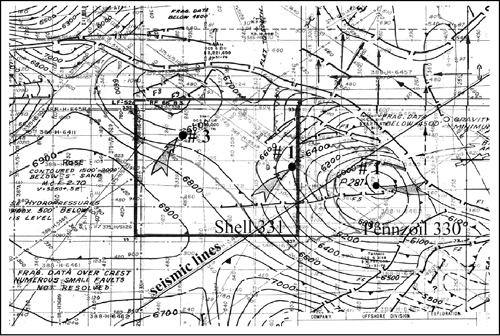
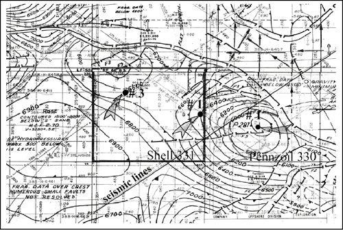
 Figure 7. Structure map, Prospect Posy,
EI 330 Field, contoured on “J” sand, which, at approximately 1.7
seconds, has a good “Bright Spot” that conforms to structural closure.
Interpretation by Mike Forrest. Primary crest of structure (in Block
330) and secondary crest (in Block 331) are part of a large closure
extending through several blocks. Location of northeast-southwest
seismic lines (Figures 8
and 9), as well as the locations of Shell 331
#3, Shell 331 #1, and Pennzoil 330 #1 wells and cross-section through
them. Figure 7. Structure map, Prospect Posy,
EI 330 Field, contoured on “J” sand, which, at approximately 1.7
seconds, has a good “Bright Spot” that conforms to structural closure.
Interpretation by Mike Forrest. Primary crest of structure (in Block
330) and secondary crest (in Block 331) are part of a large closure
extending through several blocks. Location of northeast-southwest
seismic lines (Figures 8
and 9), as well as the locations of Shell 331
#3, Shell 331 #1, and Pennzoil 330 #1 wells and cross-section through
them.
 Figure 8. Northeast-southwest seismic
line (388-8486) across the main structure that is located in Block 330,
with “Bright Spot” associated with “J” sand. Location of line shown in
Figure 7. Figure 8. Northeast-southwest seismic
line (388-8486) across the main structure that is located in Block 330,
with “Bright Spot” associated with “J” sand. Location of line shown in
Figure 7.
 Figure 9. Another northeast-southeast
seismic line (375-1127) in the same vicinity as line in Figure
8,
showing “J” sand “Bright Spot.” This seismic line is the same as shown
in Figure 6.
Location of line shown in Figure
7. Figure 9. Another northeast-southeast
seismic line (375-1127) in the same vicinity as line in Figure
8,
showing “J” sand “Bright Spot.” This seismic line is the same as shown
in Figure 6.
Location of line shown in Figure
7.
 Figure 10. Map of “J” sand “Bright Spot”
outline, which conforms to structural closure, as shown in Figure
7.
Outline is based on unmigrated seismic data; the Fresnel Zone correction
and outline after structural migration are also shown. Figure 10. Map of “J” sand “Bright Spot”
outline, which conforms to structural closure, as shown in Figure
7.
Outline is based on unmigrated seismic data; the Fresnel Zone correction
and outline after structural migration are also shown.
Click here for sequence of Figures 7 and
10 (structure and “Bright Spot” outline, respectively).
 Figure 11. Seismic line over crest of
Prospect Posy, together with Amplitude/Background (A/B) measurements at
“J” sand level. Line is through location of Shell#1 well. Measurements
were made using program called Payzo, written by Aubrey Bassett, Shell
Geophysicist. Figure 11. Seismic line over crest of
Prospect Posy, together with Amplitude/Background (A/B) measurements at
“J” sand level. Line is through location of Shell#1 well. Measurements
were made using program called Payzo, written by Aubrey Bassett, Shell
Geophysicist.
 Figure 12. Map of Amplitude/Background
at “J” sand level, Prospect Posy. In much of the updip area, A/B is
about four; there is consistent strong amplitude in the area around the
location of Shell #3 well. Figure 12. Map of Amplitude/Background
at “J” sand level, Prospect Posy. In much of the updip area, A/B is
about four; there is consistent strong amplitude in the area around the
location of Shell #3 well.
Click here for sequence of Figures 7,
10, and 12 (structure, “Bright Spot” outline, and B/A, respectively).
 Figure 13. Portion of east-west seismic
line 388-6411 through the location of Shell # 3 well. Note the good
“Bright Spot” at “J” sand level with a “Flat Spot” indicating a thick
pay. Location of line shown in Figure 7. Figure 13. Portion of east-west seismic
line 388-6411 through the location of Shell # 3 well. Note the good
“Bright Spot” at “J” sand level with a “Flat Spot” indicating a thick
pay. Location of line shown in Figure 7.
 Figure 14. Map of “J” sand gross
thickness, Prospect Posy, prepared by Chuck Roripaugh, Shell
geophysicist, from seismic data. Gross thickness of more than 150 feet
in northwest portion of Block 331 in area of Shell #3 well thins to less
than 60 feet on crest of structure in Block 330. Figure 14. Map of “J” sand gross
thickness, Prospect Posy, prepared by Chuck Roripaugh, Shell
geophysicist, from seismic data. Gross thickness of more than 150 feet
in northwest portion of Block 331 in area of Shell #3 well thins to less
than 60 feet on crest of structure in Block 330.
Click here for sequence of Figures 7,
10, 12, and 14 (structure, “Bright Spot” outline, B/A, and gross sand
thickness, respectively).
 Figure 15. Portion of well log from
Shell # 3 well, showing 160 feet of gross sand in the “J” sand interval,
with 66 net feet gas (NFG). Location of well shown in Figure 7. Figure 15. Portion of well log from
Shell # 3 well, showing 160 feet of gross sand in the “J” sand interval,
with 66 net feet gas (NFG). Location of well shown in Figure 7.
 Figure 16. Geologic cross-section from
Shell #3 well to Pennzoil #1 well. Note the multiple oil and gas pays
and the thinning of the gross interval and of individual sands from
Block 331 to crest of structure in Block 330. Line of section shown in
Figure 7. Figure 16. Geologic cross-section from
Shell #3 well to Pennzoil #1 well. Note the multiple oil and gas pays
and the thinning of the gross interval and of individual sands from
Block 331 to crest of structure in Block 330. Line of section shown in
Figure 7.
 Figure 17. Seismic acoustic impedance
log from data in Shell #1 well, with pays annotated, compared to the
seismic data, across the well, in Runsum format. Runsum, developed after
the 1970 sale, is a pseudo-acoustic impedance log derived by integrating
the seismic trace (running sum = Runsum). Figure 17. Seismic acoustic impedance
log from data in Shell #1 well, with pays annotated, compared to the
seismic data, across the well, in Runsum format. Runsum, developed after
the 1970 sale, is a pseudo-acoustic impedance log derived by integrating
the seismic trace (running sum = Runsum).
 Figure 18. Reflection coefficient vs.
depth for Plio-Pleistocene trend. These “trend curves” were derived from
petrophysical data acquired in the Pleistocene trend during 1970/1971. Figure 18. Reflection coefficient vs.
depth for Plio-Pleistocene trend. These “trend curves” were derived from
petrophysical data acquired in the Pleistocene trend during 1970/1971.
Eugene Island (EI) 330 Field,
1969-1970
Development
Posy was one of the first prospects
where Shell made detail amplitude and thickness measurements. Shell
leased EI Block 331 and discovered 150 MMBOE. Ultimate recovery of the
entire EI 330 Field, in the Plio-Pleistocene trend, is 750 MMBOE.
Prospect Posy at “J” sand level, at
approximately 1.7 seconds, has a good “Bright Spot” that conforms to
structural closure, as interpreted by the author. The primary crest of
the structure is located in the middle of Block 330, but a secondary
crest is present in the north half of Block 331(Figure
7); both crests
are part of a large closure that spans several offshore blocks.
Northeast-southwest seismic lines across the main structure in Block 330
illustrate the “J” sand “Bright Spot” (Figures 8 and
9). These are good
examples of a prospect with amplitude anomalies in the offshore
Pleistocene, or Plio-Pleistocene, area.
The outline of “J” sand “Bright Spot,”
based on unmigrated seismic data, is shown in Figure
10.
Amplitude/Background (A/B) measurements at “J” sand level (Figure
11)
were made, using the program Payzo written by Shell Geophysicist Aubrey
Bassett. The map of Amplitude/Background measurements at the “J” sand
level shows a consistently strong amplitude in the area around Shell #3
well, and A/B in much of the updip area is approximately four (Figure
12).
Figure 13
is part of an east-west seismic line through the location of Shell # 3
well. The good “Bright Spot” at “J” sand level, with a “Flat Spot,”
indicates a thick pay. A map of “J” sand gross thickness, derived from
seismic data by Chuck Roripaugh, Shell geophysicist, shows a maximum
thickness of more than 150 feet in the northwestern part of Block 331 in
the area of Shell #3 to less than 60 feet on the crest of the structure
in Block 330 (Figure 14).
Potential reserves in the “J” sand, along with those in the deeper “L”
sand, were calculated by Leighton Steward, Shell geology project leader,
and Shell bid and won Block 331 for $13 million in the 1970 lease sale.
There was a good match between seismic
interpretation and well data (Figure 15). In Shell #3 well, the “J” sand
interval has 160 feet of gross sand, with 66 net feet gas. Further,
additional well data confirmed the thinning of the gross interval and of
individual sands from Block 331 to Block 330 (Figure
16). All of the oil
and gas pays correlate with amplitude anomalies of varying quality. The
seismic data across the well
(shown as
a pseudo-acoustic impedance log [Runsum format, which is the
mathematical integration of the seismic trace]), compared to seismic
acoustic impedance derived from data in Shell #1 well, also show good
correlation of seismic and well data (Figure
17).
Crossplots
called “trend curves” show reflection coefficient vs. depth for gas,
oil, and wet sands
(Figure
18), derived
from petrophysical data acquired in 1970/1971 from wells in the
Pleistocene trend, were used to help interpret amplitude anomalies in
the 1972 Federal lease sale. Petrophysical “trend curves” are more
complex than shown, as sand quality plays a major role in petrophysical
measurements and interpretation.
Return
to top.
Summary
The first mapping of
Amplitude/Background and thickness was performed by Shell at Prospect
Posy. The “J” sand was characterized as thick gas pay, and in hindsight
the “L” sand was the first oil “Bright Spot.” In addition, several other
qualitative “Bright Spots” defined pays. As noted above, Eugene Island
330 Field has ultimate recoverable hydrocarbons of 750 MMBOE (Holland et
al., 1990;
1999), with Shell Block 331 contributing 150 MMBOE.
Figure Captions (19-23)
 Figure 19. Structure map, Prospect Pine,
South Marsh Island 130, near top of stacked seismic amplitude sequence.
Interpretation by Jules Laine, Shell geophysicist. Figure 19. Structure map, Prospect Pine,
South Marsh Island 130, near top of stacked seismic amplitude sequence.
Interpretation by Jules Laine, Shell geophysicist.
 Figure 20. East-southeast-west-northwest seismic line,
Prospect Pine and West Pine. Stacked “Bright Spots” on west flank of the
salt/shale diapir are oil and gas pays; the single “Bright Spot” across
the syncline to the west at Prospect West Pine is caused by
low-saturation gas. Figure 20. East-southeast-west-northwest seismic line,
Prospect Pine and West Pine. Stacked “Bright Spots” on west flank of the
salt/shale diapir are oil and gas pays; the single “Bright Spot” across
the syncline to the west at Prospect West Pine is caused by
low-saturation gas.
 Figure 21. East-west Runsum
(pseudo-acoustic impedance log) cross-section, Prospect Pine, of seismic
amplitude package. Figure 21. East-west Runsum
(pseudo-acoustic impedance log) cross-section, Prospect Pine, of seismic
amplitude package.
 Figure 22. East-west geologic
cross-section through the first two exploration wells in Prospect Pine,
a downdip and an updip test, both with oil and gas pays. Figure 22. East-west geologic
cross-section through the first two exploration wells in Prospect Pine,
a downdip and an updip test, both with oil and gas pays.
 Figure 23. Synthetic seismogram from
petrophysical data from Shell #1 and #2 wells, Prospect Pine, with
oil/gas pay thicknesses. Figure 23. Synthetic seismogram from
petrophysical data from Shell #1 and #2 wells, Prospect Pine, with
oil/gas pay thicknesses.
South Marsh Island (SMI) 130 Field,
1972-1973
Development
First detail application of Runsum
seismic processing was made at Prospect Pine, and there was calibration
to petrophysical trend curves. “Bright Spots” were used successfully to
predict oil pays; this was very important at the time as oil was a much
more valuable resource than gas.
In 1972,
the Prospect Pine structure was depicted by Jules Laine, Shell
geophysicist, as a small salt/shale diapir with a radial fault pattern
and a downthrown fault block on the west flank where the best amplitude
anomalies were observed (Figure 19).
West Pine is shown as a southeast-dipping structure bounded by faults.
Laine also made the “Bright Spot” interpretation.
Stacked “Bright Spots” are present on
west flank of Prospect Pine, and a single “Bright Spot” is present
across the syncline to the west at Prospect West Pine (Figure
20). The
Pine amplitudes are oil and gas pays, whereas the West Pine amplitude,
which has the same measured amplitude as an oil pay across the syncline
at Pine, is caused by low-saturation gas in a sand. Shell tested low
quantities of gas, and the sonic log showed cycle skipping, suggesting
that the sand had about 10% gas saturation. The theory of low-saturation
gas sands having seismic amplitudes as high-saturation gas sands was
developed at about the same time as the West Pine observation.
Figure 21 shows the Runsum of the
Prospect Pine seismic amplitude package in an east-west cross-section,
with potential pays being represented by this format of integrating the
seismic trace. For comparison, a geologic cross-section through the
first two exploration wells in Prospect Pine shows oil and gas pays in
both a downdip and an updip test (Figure 22). The synthetic seismogram
derived from petrophysical data from two exploration wells at Prospect
Pine shows features correlative with oil/gas pay thicknesses (Figure
23).
Summary
The first application of Runsum
processing and petrophysical “trend curves” was at Prospect Pine/West
Pine. The original estimate of 100MMBO was based on high probability
“oil calls.” The current estimate of total recoverable hydrocarbons is
more than 250 MMBOE. First recognition of low-saturation gas problem (LSG)
was at West Pine.
Recoverable Hydrocarbons
Shell discoveries using
“Bright Spots” on the shelf of the Gulf of Mexico (GOM) are estimated to
found 1.5 to 2 BBOE. In GOM deep water, the estimate of recoverable
hydrocarbons is approximately 4 BBOE. The present of “Bright Spots” was
a key factor in entering GOM Deep Water during 1983 to 1986.
Lessons from Shell initial “Bright Spot”
studies and Prospect Posy and Pine successes
-
Good ideas come from operations
people; these need to be followed-up with research team(s).
-
New ideas require persistence. “Beware
of the skeptics.”
-
In hindsight, good ideas are very
often simple and easy to understand.
-
If technical staff and management
agree on application of new technology, “go for it.”
Shell Team Members - 1967
to 1972
Successful exploration is
always a team effort. Each of the persons listed below played a
significant role in “Bright Spot” technology studies. Spot” technology studies.
Billy Flowers, Glenn Robertson, Mike
Forrest, Urban Allen, Dick Grolla, Aubrey Bassett, Chuck Roripaugh, Ray
Thomasson, Leighton Steward, “Mac” McAdams, Miner Long, Manny Baskir,
Dave DiMartini, Gene McMahan, Lee Backsen, Bill Scaife, Harlan Ritch,
Sam Mitchell, J.T. Smith, Jules Laine, and others.
References
David S.
Holland, John B. Leedy, David R. Lammlein, 1990, Eugene Island Block 330
Field—U.S.A. Offshore Louisiana, in Structural Traps III: Tectonic Fold
and Fault Traps: AAPG Treatise of Petroleum Geology Atlas of Oil and Gas
Fields, p. 103-143.
David S.
Holland, John B. Leedy, David R. Lammlein, 1990, Eugene Island Block 330
Field—U.S.A. Offshore Louisiana, Search and Discovery Article #20003 (http://www.searchanddiscovery.net/documents/97015/eugene.htm).
Return
to top.
|