![]() Click here to view original article in pdf format.
Click here to view original article in pdf format.
COALBED METHANE: LOUISIANA'S UNDEREXPLOITED ENERGY RESOURCE
John B. Echols1
Search and Discovery Article #10011 (2000)
Adaptation for online presentation of article of the same title by the same author published in Volume 9, pages 18-27 (June, 2000) of the Basin Research Institute Bulletin, a publication of the Louisiana Geological Survey. Website of BRI is www.lgs.lsu.edu.
1Louisiana Geological Survey, Louisiana State University, Baton Rouge, Louisiana 70803
The Central Louisiana Coalbed Methane Basin (CELCOM) is part of a much larger coalbed methane basin, the Tertiary Coalbed Methane Basin, which covers parts of seven states. It is given its own name primarily for the purpose of reference in communication. In the entirety of the Tertiary Coalbed Methane Basin, there appears to be only one coalbed methane gas-producing well. This well was completed in the CELCOM in 1989. Within the United States, there are 16 known coalbed methane basins that contain approximately 8,000 methane gas-producing wells. To date, coalbed methane production accounts for about 6% of the national total of gas production.
Coalbed methane gas (CH4) is produced by bacteria that feed on coalbeds. The gas is adsorbed onto the coal itself and is produced as the water from the coal is removed. Coalbed methane is 98% (or greater) pure CH4. Analysis of the coalbed methane gas showed it to be 99.94% pure methane.

![]() Figure 3 - Idealized illustration of stratigraphic
capture process.
Figure 3 - Idealized illustration of stratigraphic
capture process.

 Figure 4 - Interpretation of electric log data of the
Wilcox group in the Tertiary illustrates, in sections, its geologic history (Select
A, B, C, or
D). *Detailed description for each at
end of "List of Figures."
Figure 4 - Interpretation of electric log data of the
Wilcox group in the Tertiary illustrates, in sections, its geologic history (Select
A, B, C, or
D). *Detailed description for each at
end of "List of Figures."
Click here for composite log of A.-D. comprising Figure 4.

 Figure 6 - Location of CELCOM in regional geologic
setting of Louisiana.
Figure 6 - Location of CELCOM in regional geologic
setting of Louisiana.
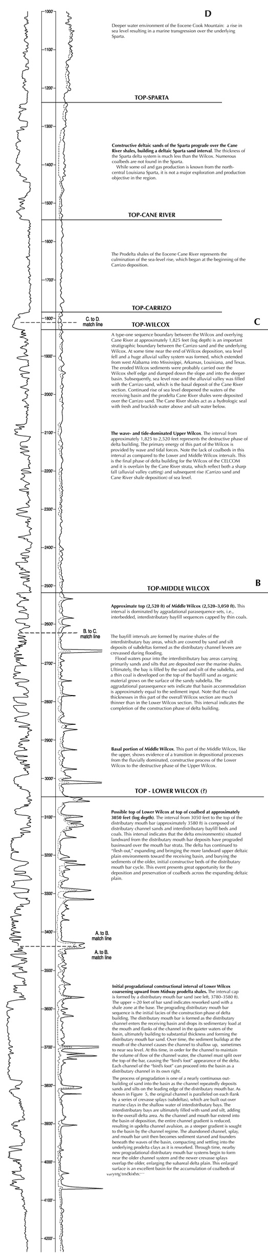
Figure 4A - Initial progradational constructional interval of Lower Wilcox coarsening upward from Midway prodelta shales. The interval cap is formed by a distributary mouth bar sand (see left, 3780–3580 ft). The upper +-20 feet of bar sand indicates reworked sand with a shale zone at the base. The prograding distributary mouth bar sequence is the initial facies of the construction phase of delta building. The distributary mouth bar is formed as the distributary channel enters the receiving basin and drops its sedimentary load at the mouth and flanks of the channel in the quieter waters of the basin, ultimately building to substantial thickness and forming the distributary mouth bar sand. Over time, the sediment buildup at the mouth of the channel causes the channel to shallow up, sometimes to near sea level. At this time, in order for the channel to maintain the volume of flow of the channel water, the channel must split over the top of the bar, causing the "bird’s foot" appearance of the delta. Each channel of the "bird’s foot" can proceed into the basin as a distributary channel in its own right.
The process of progradation is one of a nearly continuous out-building of sand into the basin as the channel repeatedly deposits sands and silts on the leading edge of the distributary mouth bar. As shown in Figure 5, the original channel is paralleled on each flank by a series of crevasse splays (subdeltas), which are built out over marine clays in the shallow water of interdistributary bays. The interdistributary bays are ultimately filled with sand and silt, adding to the overall delta area. As the channel and mouth bar extend into the basin of deposition, the entire channel gradient is reduced, resulting in updelta channel avulsion, as a steeper gradient is sought to the basin by the channel regime. The abandoned channel, splay, and mouth bar unit then becomes sediment starved and founders beneath the waves of the basin, compacting and settling into the underlying prodelta clays as it is reworked. Through time, nearby new progradational distributary mouth bar systems begin to form near the older channel system and the newer crevasse splays overlap the older, enlarging the subareal delta plain. This enlarged surface is an excellent basin for the accumulation of coalbeds of varying thickness.
Figure 4B - The bayfill intervals are formed by marine shales of the interdistributary bay areas, which are covered by sand and silt deposits of subdeltas formed as the distributary channel levees are crevassed during flooding.
Flood waters pour into the interdistributary bay areas carrying primarily sands and silts that are deposited over the marine shales. Ultimately, the bay is filled by the sand and silt of the subdelta, and a thin coal is developed on the top of the bayfill sand as organic material grows on the surface of the sandy subdelta. The aggradational parasequence sets indicate that basin accommodation is approximately equal to the sediment input. Note that the coal thicknesses in this part of the overall Wilcox section are much thinner than in the Lower Wilcox section. This interval indicates the completion of the construction phase of delta building.
Basal portion of Middle Wilcox. This part of the Middle Wilcox, like the upper, shows evidence of a transition in depositional processes from the fluvially dominated, constructive process of the Lower Wilcox to the destructive phase of the Upper Wilcox.
TOP - LOWER WILCOX (?)
Possible top of Lower Wilcox at top of coalbed at approximately 3050 feet (log depth). The interval from 3050 feet to the top of the distributary mouth bar (approximately 3580 ft) is composed of distributary channel sands and interdistributary bayfill beds and coals. This interval indicates that the delta environment(s) situated landward from the distributary mouth bar deposits have prograded basinward over the mouth bar strata. The delta has continued to "flesh out," expanding and bringing the more landward upper deltaic plain environments toward the receiving basin, and burying the sediments of the older, initial constructive beds of the distributary mouth bar cycle. This event presents great opportunity for the deposition and preservation of coalbeds across the expanding deltaic plain.
Figure 4C - A type-one sequence boundary between the Wilcox and overlying Cane River at approximately 1,825 feet (log depth) is an important stratigraphic boundary between the Carrizo sand and the underlying Wilcox. At some time near the end of Wilcox deposition, sea level fell and a huge alluvial valley system was formed, which extended from west Alabama into Mississippi, Arkansas, Louisiana, and Texas. The eroded Wilcox sediments were probably carried over the Wilcox shelf edge and dumped down the slope and into the deeper basin. Subsequently, sea level rose and the alluvial valley was filled with the Carrizo sand, which is the basal deposit of the Cane River section. Continued rise of sea level deepened the waters of the receiving basin and the prodelta Cane River shales were deposited over the Carrizo sand. The Cane River shales act as a hydrologic seal with fresh and brackish water above and salt water below.
The wave- and tide-dominated Upper Wilcox. The interval from approximately 1,825 to 2,520 feet represents the destructive phase of delta building. The primary energy of this part of the Wilcox is provided by wave and tidal forces. Note the lack of coalbeds in this interval as compared to the Lower and Middle Wilcox intervals. This is the final phase of delta building for the Wilcox of the CELCOM and it is overlain by the Cane River strata, which reflect both a sharp fall (alluvial valley cutting) and subsequent rise (Carrizo sand and Cane River shale deposition) of sea level.
TOP-MIDDLE WILCOX
Approximate top (2,520 ft) of Middle Wilcox (2,520–3,050 ft). This interval is dominated by aggradational parasequence sets, i.e., interbedded, interdistributary bayfill sequences capped by thin coals.
Figure 4D - Deeper water environment of the Eocene Cook Mountain: a rise in sea level resulting in a marine transgression over the underlying Sparta.
TOP-SPARTA
Constructive deltaic sands of the Sparta prograde over the Cane River shales, building a deltaic Sparta sand interval. The thickness of the Sparta delta system is much less than the Wilcox. Numerous coalbeds are not found in the Sparta.
While some oil and gas production is known from the north-central Louisiana Sparta, it is not a major exploration and production objective in the region.
TOP-CANE RIVER
The Prodelta shales of the Eocene Cane River represents the culmination of the sea-level rise, which began at the beginning of the Carrizo deposition.
TOP-CARRIZO
Geology of the Late Paleocene Midway and Early Wilcox in the CELCOM Area:
Geology of the Early Wilcox Sediments of the CELCOM
There are 16 known coalbed methane gas-producing basins in the continental United States. One of the largest is the Tertiary Coalbed Methane Basin, which contains the Central Louisiana Coalbed Methane Basin (CELCOM) and covers parts of the seven states of Florida, Alabama, Mississippi, Tennessee, Arkansas, Texas and Louisiana (Fig. 1). However, for all practical purposes, the potential coalbed methane gas resources of this basin are totally unknown. The only known coalbed methane gas-producing well in this entire Tertiary basin area was completed in Louisiana in April 1989 by Torch Operating Company, Dallas, Texas (Fig. 2), in Caldwell Parish. It was plugged and abandoned in December 1989. Presently, in the other coalbed methane basins of the United States, there are about 8,000 coalbed methane- gas producing wells. In the last two decades, the total coalbed methane gas production in the United States is in excess of 7 Tcf , a value of $156.1 billion, at $2.23/mcf (Nelson, 1999).
Coalbed methane gas is a very pure form of methane or "natural" gas, whose volume is composed of the molecule CH4 in amounts of 98% or greater. It is also known as "dry gas," and "biogenic gas." Coalbed methane gas is sourced, or generated, within a coalbed, and is created by the action of methanogenic bacteria on coal. The bacteria ingest the carbon from the coal, and by the process of bacterial fermentation, generate methane gas, which is adsorbed onto the coalbed itself. This occurs only under anaerobic conditions, where little sulphate or interstitial water is present in the coal. Coalbed methane gas is usually reservoired in the coalbed and is produced from the coalbed itself. However, as is discussed later, in some instances coalbed methane is produced from reservoirs other than coalbeds. Coalbed methane gas differs from a second, but more common form of gas, called "wet" gas, that is composed of 98% or less of methane and usually produced from reservoirs other than coal. Wet gas is formed by the process of catagenesis.
Catagenesis is the thermal alteration of organic matter in sediments. Kerogen is particulate organic material that is contained in sediments. It is insoluble in organic solvents, and originates from elements of animals, plants, and bacteria. As the sediments containing the kerogen are buried increasingly deeper, and heated to temperatures upward of 1500 C over long periods of time, perhaps millions of years, the kerogen decomposes to crude oil and wet gas. With yet deeper burial, the additional components forming wet gas are "burned out" of the kerogen, resulting in the complete decomposition and disappearance of the kerogen. At this stage the kerogen is "burned out" of the sediments and is incapable of producing any more hydrocarbons.
In late 1993 and early 1994, as part of another project, the author was attempting to discover the nature of the produced Wilcox gas, which he assumed to be generated by catagenesis from the deep Jurassic beds underlying the CELCOM, and put in place in the Wilcox sand reservoirs by migration of the gas up vertical fractures. It was a great surprise to learn that the gas was biogenic (99.94% pure methane), and was sourced by bacterial action on the Paleocene-Eocene Wilcox coalbeds. Further, geologic studies indicated that the gas was placed into the reservoirs by the process the author and a colleague in an earlier report (Echols and Goddard, 1992) termed "stratigraphic capture" (Fig. 3). Stratigraphic capture is a process whereby younger strata cut into older, underlying strata and allow gasses and liquids in the older strata to escape into the sand-filled channels of the younger strata. Coalbeds that are scoured by the younger channels bleed gas into the sand-filled channels. The gas then migrates updip into traps within the sandstone of the channel fill from which it is produced.
The geologic history of the Wilcox of the CELCOM area (Fig. 4) is conducive to the formation of coalbeds variable in both extent and thickness.
Geology of the Late Paleocene Midway and Early Wilcox in the CELCOM Area:
The Prodelta Midway Shale and Fluvially Dominated Wilcox Deltas
H. V. Andersen, 1993, identified the depositional environment of the Paleocene Midway shales of Natchitoches Parish, Louisiana, as inner to outer neritic (120-300 ft water depth). Northeast Natchitoches Parish is located about 50 miles west of the central area of the CELCOM, and generally along structural and stratigraphic strike with it. Anderson's water depth estimate identifies the depositional environment of the Midway in these areas as prodelta.
Approximately 60 million years ago, at the beginning of Wilcox time, through a combination of uplift and fall of sea level, the interior of North America was sufficiently elevated above sea level to begin a cycle of erosion that resulted in the transportation of large volumes of sand, silt, and clay into the Gulf of Mexico basin of deposition, which includes the CELCOM.
The prodelta Midway shales are the product of erosion of the distant interior bedrock of the North American continent. The Midway depositional environment was far removed from the interior sediment sources and the majority of sediments reaching the prodeltaic depositional sites of the Midway were clays, later compacted to shale. With the passage of time, the streams carrying the coarser detritus and lesser amounts of clays reached the CELCOM area. These sediment-laden streams prograded out over the surface of the prodelta Midway shales in the initial stages of the constructive delta building of the Wilcox. This constructive process created a new and distinct depositional environment: a fluvially dominated deltaic environment. It is in this setting that the coalbeds of the CELCOM were deposited.
Galloway and Hobday (1983) identify two processes that control deposition in delta systems: the constructive process and the destructive process. In a constructive, fluvially dominated delta, the sediment input is greater than the energy of the receiving basin to rework and modify the delta. In the destructive process, wave and tidal energy rework, redistribute and remove some of the sediments of the constructive phase.
Geology of the Early Wilcox Sediments of the CELCOM
Approximately 60 million years ago, the sediments of the Wilcox in the CELCOM area were deposited by sediment-laden rivers prograding into the CELCOM area. These rivers, called distributaries, prograded basinward and constructed a dominately sandstone structural and stratigraphic framework into and on top of the older prodelta shales of the Midway. Through time, the framework developed into overlapping deltas composed of many subsidiary depositional environments that contained numerous and, in some cases, thick coalbeds. Figure 4 illustrates the geologic history of the Wilcox of the CELCOM as can be interpreted by using electric log data.
The geologic evidence indicates a prograding, fluvially dominated history for the lower Wilcox of the CELCOM. Subsequently, the middle Wilcox prograded basinward over the lower Wilcox and indicates a transition from the progradational environment to an environment of multiple aggradational parasequence sets, where basin subsidence closely approximated the rate of sedimentation. Finally, basin subsidence gave way to a wave- and tidal-dominated destructional phase where the sediments of the delta were reworked and redistributed as they built out over the underlying middle and lower Wilcox strata. The first two phases in the lower and middle Wilcox resulted in coalbed deposition; the final, upper Wilcox indicates that the coalbeds, if deposited, were largely reworked and removed from the delta complex.
The CELCOM has only one completed and produced coalbed methane gas well. However, the geologic evidence indicates a much larger area (Fig. 6) with probable coalbed methane gas-producing potential. Interpretation of the geologic evidence indicates that the geologic history of the area is conducive to the development of widespread coalbeds with sufficient thickness to provide profitable gas well completion attempts in the area. An exploratory test well is called for at this time to answer the question.
The author extends his gratitude to the staff and director of the Basin Research Institute for their assistance in the preparation of this report. In particular, I would like to thank Riley Milner for his assistance in the research, Clifford Duplechin and Mary Lee Eggert for the preparation of the figures and other illustrations which accompany the report. Finally, my thanks to Margo Olinde for her talented editing efforts to make the article readable.
Andersen, H.V., 1993, Geology of Natchitoches Parish: Louisiana Geological Survey, Geological Bulletin n. 44, 227 p.
Coleman, J.M. and S.M. Gagliano,, 1964, Cyclic sedimentation in the Mississippi River deltaic plain: Gulf Coast Association of Geological Societies Transactions, v. 24, p.67-80.
Echols, J.B. and D.M. Goddard,, 1992, Stratigraphic capture: a depositional process facilitating fluid and gas movement between porous and permeable beds: Gulf Coast Association of Geological Societites Transactions, v. 42, p.121-133.
Galloway, W.E. and D.K. Hobday, 1983, Terrigenous Clastic Depositional Systems: Applications to Petroleum, Coal, and Uranium Exploration: Springer-Verlag, New York, 413 p.
Nelson, C. R., 1999, Changing perceptions regarding the size and production potential of coalbed methane resources: Gas Research Institute, Gas Tips, Summer 1999, v. 5, n. 2, p. 4-11.