3D GEOMETRY AND EVOLUTION OF SHALE DIAPIRS IN THE EASTERN VENEZUELAN BASIN*
Leonardo Duerto1,2 and Ken McClay1
Search and Discovery Article #10026 (2002)
*Adapted for online presentation from poster session by the authors at the AAPG Convention, Houston, Texas, March, 2002.
1Fault Dynamics Research Group, Royal Holloway, University of London, ([email protected]; [email protected]), and 2PETROLEOS DE VENEZUELA (PDVSA)
* Editorial Note: This article, which is highly graphic (or visual) in design, is presented as: (1) three posters, with (a) each represented in JPG by a small, low-resolution image map of the original; each illustration or section of text on each poster is accessible for viewing at screen scale (higher resolution) by locating the cursor over the part of interest before clicking; and (b) each represented by a PDF image, which contains the usual enlargement capabilities; and (2) searchable HTML text with figure captions linked to corresponding illustrations with descriptions.
Users without high-speed internet access to this article may experience significant delay in downloading some illustrations due to their sizes.
First Poster
Second Poster
Third Poster
The
frontal fold of the Interior Range fold Belt of Eastern Venezuelan Basin (EVB)
is characterized by a 150 Km long and 15 Km wide N20E oriented mud diapir belt.
Four types of diapirism related folding have been identified based on
morphology, growth strata geometries, and shortening. The mechanism of folding
is a progressive rotation and limb length ![]() variation
variation![]() due to the rise of Lower
Middle Miocene shale. Diapirs developed from west to east controlled mainly by
the advancing underlying thrust sheets during the Caribbean Collision in the
area. Shale shows strong lateral variations in composition, the most mobile
shale is restricted to the basin foredeep. There are evidences of early diapiric
intrusions and diapiric evolution from west to east. The initial age of shale
movement is late Miocene and has a continuous movement record until end
Pliocene-Early Pleistocene. Calderas and toe thrusts are potential exploration
targets.
due to the rise of Lower
Middle Miocene shale. Diapirs developed from west to east controlled mainly by
the advancing underlying thrust sheets during the Caribbean Collision in the
area. Shale shows strong lateral variations in composition, the most mobile
shale is restricted to the basin foredeep. There are evidences of early diapiric
intrusions and diapiric evolution from west to east. The initial age of shale
movement is late Miocene and has a continuous movement record until end
Pliocene-Early Pleistocene. Calderas and toe thrusts are potential exploration
targets.
|
|
FIGURE CAPTIONS (First Poster) Click on EVB for view of geological map (Fig. 1-2).
Location is shown on Figure 1-2.
Table 1-1. Mud Volcanoes and associated oil or gas shows. (Source: Petito, 1979). The EVB is located in the triple junction of the North American Plate, the Caribbean Plate and the South American Plate. The Eastern Venezuelan Basin (EVB, Fig.1-1) is the second most important basin in Venezuela for oil potential. It contributes with almost 40 % of the present-day hydrocarbon production. The basin, opened to the east, is overlain by a great amount of mud volcanoes as well as gas and oil seepages (Fig.1-7). Diapirs have always been seen as obstacles in the interpretation of the underlying oil-rich Cretaceous units. The increasing need of new discoveries has motivated a better understanding of shale diapirs as they have an important sedimentary control on the distribution of Neogene reservoir sands. More than 25,000 feet of sediments from Cretaceous through present day have accumulated in the EVB (Fig.1-2). The history of sedimentation started in Cretaceous time with the development of a carbonate platform (Fig.1-3). These carbonates represented by the Guayuta Group were deformed in Oligocene - Early Miocene time due to the subduction of the Caribbean Plate and related imbrication and duplexing (Fig. 1-3). During Oligo-Miocene, deep water shales and turbidites were deposited in the foredeep. These shales and turbidites, which have an important HC potential, were remobilized into diapirs at the deformation front during the final stages of the basin evolution (Fig. 1-3). Prior to the deposition of nearshore to continental facies of upper La Pica, Las Piedras, and Mesa formations, listric faults were developed over Early-Middle Miocene shales. The Caribbean Plate displacement gave rise to an eastward migration of the depocenters (Di Croce et al., 2000, Fig. 1-4). Shales deposited in the foredeep (Fig. 1-5) are called Roblecito in the West, Carapita in the Maturin area, and La Pica in the East of the EVB (Fig.1-4).
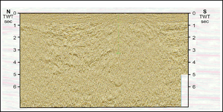
The
seismic data from the EVB is generally poor due to the occurrence of
gas, shale, and high bedding dips associated with the complex structure
of the area (Fig. 1-6). The top of Cretaceous generally has a strong
With Upper Miocene M3 and M3a surfaces, angularities were developed, as shown in all the seismic data, within the depositional sequence until Pleistocene, when changes in sedimentation rate took place. MUD VOLCANOES AND SEEPAGESThe diapirs are surrounded by numerous oil fields (Fig. 1-7). The most important field related to the sedimentary wedge over the shales is Pedernales, which comprises production and reservoir zones of Miocene age. One of the main characteristic of the diapirs is the presence of mud volcanoes. From Maturin Town to the east, many mud volcanoes have been reported (Petito,1979). Although small, no more than 10 m. high (Fig. 1-8), they are frequently related to gas and oil seepages (Fig. 1-9). Mud volcanoes are E-W aligned and continue through Trinidad and offshore Barbados Ridge Complex (Huyghe et al., 1999). Studies on the NE-SW-oriented mud volcanoes of the Columbus Basin (Zamora, 1999) indicate a strong sedimentary loading and the existence of counter regional listric faulting through which there were shale growths in the form of diapirs and mud volcanoes. Figure Captions (Second Poster)
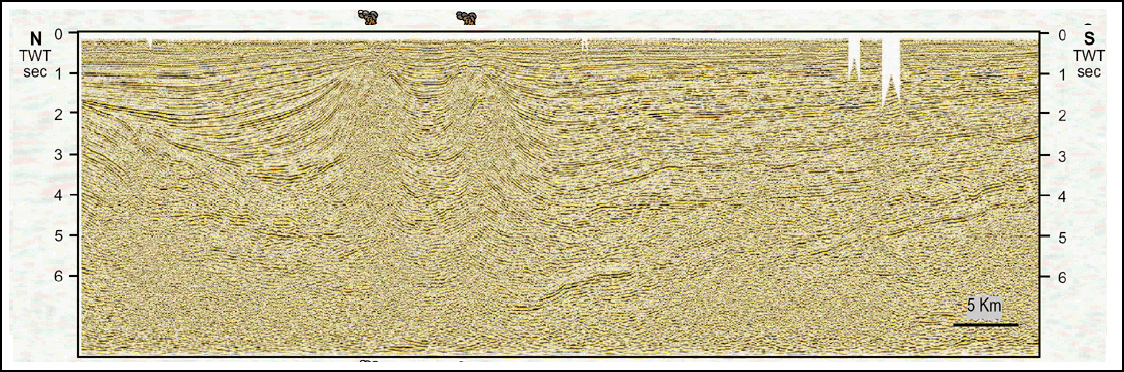
This research involves interpretation of 219 2D seismic lines covering more than 10.000 km, recorded from 1969 to 1994. The seismic data were combined with information from 23 selected wells. In addition to standard seismic interpretations detailed structural analyses consisted of shortening calculations (using bed lengths) above and below the ductile shales in the sections (Fig. 2-1). Shortening analyses together with the seismic interpretations enabled us to divide the subject area into four zones of diapirs. The change in reflection characteristics within individual seismic lines is related to the presence of gas and low velocity materials (i.e., shale and gas). Identification of these areas permitted delineation of shale calderas and diapir conduits (Fig. 2-2.). Figure 2-3 shows representative seismic lines across diapir structures in the study area. ZONE IThis zone is in the eastern part of the diapir belt and is dominated by smooth, north-vergent anticlines that are produced as major backthrusts with detachment zones in Miocene shales. The anticlines are developed over a south-vergent thrusts system that involves Cretaceous rocks (Fig. 2-4). There are no active mud volcanoes in Zone I but there is evidence of shale diapiric activity. Line T4 shows a deformed chimney (Fig. 2-4). The chimney, onlapped by Pliocene sediments, is located over a compressional structure. The presence of this chimney indicates undercompacted sediments at the western margins of the foredeep basin. Diapir chimneys are not present in the north and south of this zone because of the lack of overpressured shales there. ZONE IIIn the northern part of this sector, the presence of normal faults above the Miocene shale section (Fig. 2-5), as well as the presence of collapsed diapirs (Fig. 2-9), is evidence of shale re-mobilisation. The initial age for shale mobilisation is Middle Miocene (Fig. 2-9), but this is probably associated with listric normal fault movement. The rise of the shale could have been initially controlled by these faults but there is no conclusive evidence. The location of the main thrusts under the shale, the changes in reflector characteristics due to low velocity materials at 2 sec. TWT, together with the growth stratal architecture at 1 sec. (Fig. 2-9), show that this was a mud volcano that initially uplifted the beds during the Pliocene but collapsed in the Pleistocene; the caldera is shown in line 8419 (Fig. 2-9). There is also evidence of mud intrusives using faults as main fluid channelways in the southern part of line T3, but these have not reached the surface. The anticline related to the diapir is southward vergent. The diapir in this zone is formed by Miocene shales that form a single rounded stock (Fig. 2-6). This zone contains the thickest shale unit in the region. The orientation of the diapir coincides with the eastern border of the main thrust sheet in the Maturin area. Mud volcanoes occur at the crest of the diapir and are formed by upward flux of overpressured shales along normal faults above the buried stock. There is no evidence of diapirism in the Late Miocene but the growth sedimentation associated with the mobilised shale indicates that the diapir structure formed mainly in the Plio-Pleistocene. These diapirs are sourced from the overpressured Miocene strata and have a double walled shape with E-W strike (Fig. 2-7). Many active mud volcanoes are present above these diapirs. The volcanoes display structures that indicate a reservoir volume together with chimneys that reach the surface along normal faults above the chamber (Fig. 2-8). Growth stratal onlaps indicate that initial diapir movement occurred in the Late Miocene. The main phase of diapir growth occurred in the Plio-Pleistocene. The post-growth strata architecture shows only slight indications of diapir reactivation. Figure Captions (Third Poster)
COMPOSITE OVERVIEW OF THE DIAPIR ZONES From the map in Figure 3-1 note that:
· The thickest shale unit is located in the east of Zone III, and the maximum depth to basement is reached between Zone II and III.
MUD DIAPIR EVOLUTION
TRIGGERING OF DIAPIRISMThe four zones of diapirism identified are related to the main thrust sheets of the area. Overpressured shales and diapirs are produced in the tip of the thrust sheets where high pore fluids pressures are favored by the high horizontal compression. Diapirs are the shallow expression of underlying tectonic structures and can be used as an indicator of thrust sheets. The initial overpressured zone must have been localized in the northeast of the foredeep at the maximum depth to the basin. The effect of the thrust system was the southeastward displacement of the shale unit and the piling of the shale in the limit of Zone III.
The area has a strong lateral
The model of folding that best suites the
folds associated with diapirs in the EVB, based on the studies on growth
folds published by Poblet et al. (1997), is a progressive rotation and
limb length Diapirs have evolved from west to east. In Zone I and II there are evidences of early diapiric intrusions that were abandoned after the thrust system move eastward. Collapses in shale deposits and remobilization was mainly driven by the thrust system evolution. The initial age for the movement of shale in the area was Late Miocene, and had a continuous development until end Pliocene-Early Pleistocene were conditions in the sedimentation-uplift rate changed. Mud diapirs can be seals for HC. The formation of calderas can favor the formation of reservoirs in Early Miocene sands (Fig 3-3). The zone with more prospectivity for this kind of accumulation is Zone IV. Another possibility of structural reservoirs is the presence of Toe Thrusts in the pregrowth sequences. The impact of argillokinesis on HC migration path and Gas is a matter to be solved by future studies, such as the analysis of diapirs morphology. Adding more 3D seismic surveys can improve the understanding of diapirism and can help to identify new HC potentials. CHEVALIER, Y. (1994) A Transverse Section from the Orinoco Oil Belt to the El Pilar Fault System. Venezuela. Lagoven. Field Trip. V Bolivarian Symposium. 100 p. COLLIER, J. (1990) Seismic Imaging of Magma Chambers and Mud Diapirs. Ph.D. Thesis Unpublished. Cambridge University. DI CROCE, J., DE TONI, B., NAVARRO, A., YSACCIS, R., ALVAREZ, E., GHOSH, S., DUERTO, L., PORRAS, L. AND VIOLINO, R. (2000) Key Petroleum Elements of the Venezuelan Basins in a Improved Chronostratigraphic Framework. AAPG, Dallas, Poster Session. FUNVISIS (1998) Vulcan Sub-Basin fault styles – implications for hydrocarbon migration and entrapment. The APEA Journal, 32, p. 138-157. HUYGHE, P., MUGNIER, J-L., GRIBOULARD, R., DENIAUD, Y., GONTHIER, E. AND FAUGERES, J-C. (1999) Review of the Tectonic Controls and Sedimentary Patterns in Late Neogene Piggyback Basins on the Barbados Ridge Complex. Caribbean Basins. Sedimentary Basins of the World. Edited by P. Mann. Series Editor: K. Hsu. p.369-388. PETITO, M. (1979) Evaluacion Preliminar del Area Maturin-Pedernales. Lagoven Internal Report. POBLET, J., McCLAY, K., STORTI, F. and MUÑOS, J. (1997) Geometric of syntectonic sediments associated with single-layer detachment folds. Journal of Structural Geology, V.19, N 3-4. p. 369-381. YORIS, F., and OSTOS, M. (1997) Geologia de Venezuela. WEB. Evaluacion de Pozos. Schumberger, Surenco, Caracas, p. 3-44. Petroleos de Venezuela (PDVSA) for providing the data set, financial and moral support. I am grateful to Dr. Ken MClay for his useful comments and suggestion which have helped me to improve the project. Special thanks to Felipe Audemard and Jairo Lugo for helping me more than I do to myself, after all these years... Finally I would like to say thanks to the Latin Mafia of Royal Holloway for their continuous cheerful encouragement. |
 Figure 1-2. Geological map of the
EVB. Note
the location of the deepest part of the basin and the shape of it.
Modified from IFP (1990)
Figure 1-2. Geological map of the
EVB. Note
the location of the deepest part of the basin and the shape of it.
Modified from IFP (1990) Figure 1-5. Sources of sediments from the
positive areas since Miocene into the EVB. Modified From Yoris and Ostos
(1997).
Figure 1-5. Sources of sediments from the
positive areas since Miocene into the EVB. Modified From Yoris and Ostos
(1997).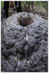 Figure 1-8. Mud Volcanoes as this one from the
Orinoco Delta are small but frequently associated with gas and
petroleum.Photo from BEG-UTexas Site.
Figure 1-8. Mud Volcanoes as this one from the
Orinoco Delta are small but frequently associated with gas and
petroleum.Photo from BEG-UTexas Site. Figure 2-2. Illustration of the changes in
reflection patterns due to diapir intrusion.
Figure 2-2. Illustration of the changes in
reflection patterns due to diapir intrusion. Figure 2-3. Location of seismic lines showed
here and wells used in the interpretation. Click on any labeled seismic
line to view it.
Figure 2-3. Location of seismic lines showed
here and wells used in the interpretation. Click on any labeled seismic
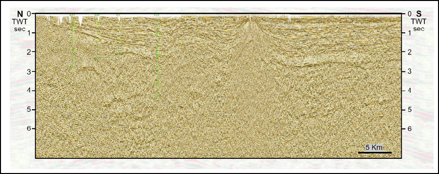
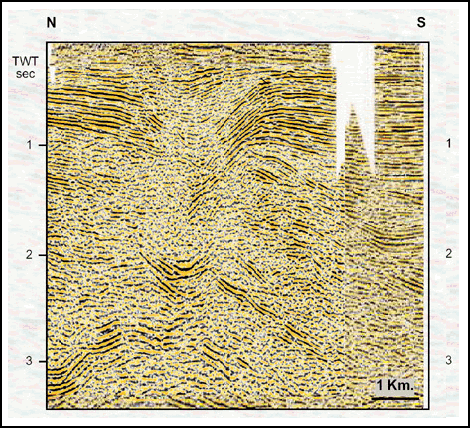
line to view it. Figure 2-4. Seismic section (Line T4) and
interpretation of a diapir in Zone I. Note the presence of a deformed
mud chimney, and backthrusting in the Miocene shales in response to
thrusting in the underlying Cretaceous units.
Figure 2-4. Seismic section (Line T4) and
interpretation of a diapir in Zone I. Note the presence of a deformed
mud chimney, and backthrusting in the Miocene shales in response to
thrusting in the underlying Cretaceous units. Figure 2-5. Seismic section (Line T3) and
interpretation of a diapir in Zone II. Note the presence of major
diapiric intrusion that used the extensional faults as fluid channelway.
Figure 2-5. Seismic section (Line T3) and
interpretation of a diapir in Zone II. Note the presence of major
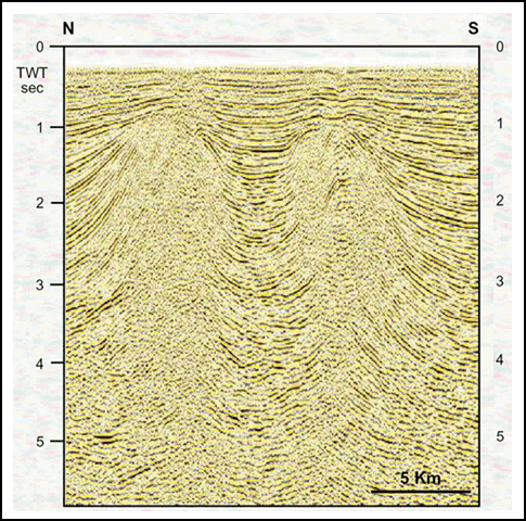
diapiric intrusion that used the extensional faults as fluid channelway. Figure 2-6. Seismic section (Line 9005) and
interpretation of a diapir in Zone III. This zone is characterized by
the thickest shale section in the region and by mud volcanism in the
crest of the structures.
Figure 2-6. Seismic section (Line 9005) and
interpretation of a diapir in Zone III. This zone is characterized by
the thickest shale section in the region and by mud volcanism in the
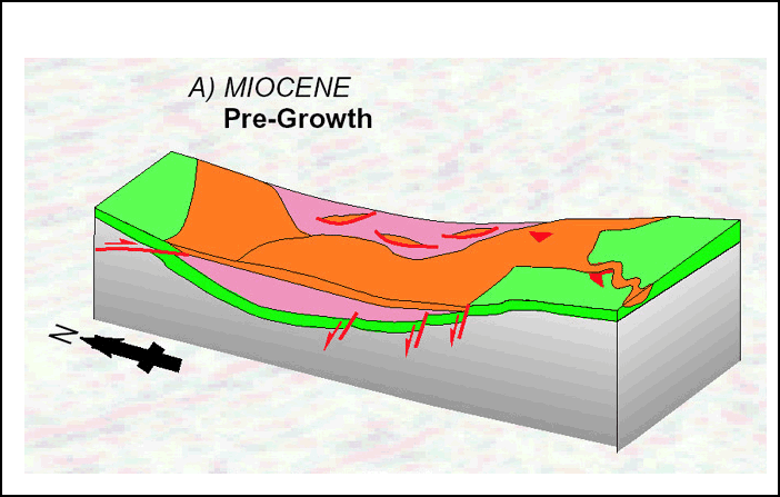
crest of the structures.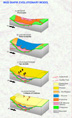 Figure 3-2. Four episodes of diapirism in
EVB.
A) Pre-growth stage, normal faulting B) Initial instability with
sedimentation controlled by diapirs rise, C) Syn-growth with the
formation of mud volcanoes and calderas. D) Collapse of calderas,
followed by the displacement of thrusting eastward.
Figure 3-2. Four episodes of diapirism in
EVB.
A) Pre-growth stage, normal faulting B) Initial instability with
sedimentation controlled by diapirs rise, C) Syn-growth with the
formation of mud volcanoes and calderas. D) Collapse of calderas,
followed by the displacement of thrusting eastward.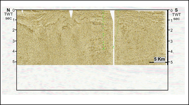