![]() Click to view article in PDF format.
Click to view article in PDF format.
Gas Prospective Areas in the Zagros Domain of Iran and in the Gulf Iranian Waters*
By
M.L. Bordenave1
Search and Discovery Article #10040a (2003)
*Adapted from “extended abstract” of presentation at AAPG Annual Meeting, March 10-12, 2002, Houston, Texas.
1Consultant, 24 Avenue President Kennedy, 75016 Paris, France
In the Province of Fars and in its offshore, gas reserves in excess of 600Tcf, discovered in Permo-Triassic carbonates well sealed by the anhydrite of the Dashtak Formation, were originated from early Llandoverian highly organic and radioactive shales. The current distribution of this source rock was influenced by the pre-Permian erosion on a system of N-S tilted blocks.
Extensive geochemical modeling has shown that oil generation began in the Middle Jurassic in some areas, while the onset of gas window was reached locally as early as Middle Cretaceous.
A suite of cumulative isopachs shows the evolution of the source rocks maturity through time. It also provides a reliable image of the geometry of the reservoirs, the long range migration and the location of large-size oil and gas accumulations on a few continuous regional highs prior to the Zagros orogeny. Huge amounts of gas and limited amounts of light oil later re-accumulated in the Zagros folds, formed during the late Miocene and Pliocene.
The characteristics of the Dalan and Kangan reservoirs and the areal extent of the Dashtak Formation, which seals the system, could be deduced from paleogeographic reconstruction, distribution of facies, and isopachs. The distribution of the reservoirs, seals, surface oil and gas seepages, and hydrocarbon-related indications, together with the location of the gas fields, make it possible to select, among the numerous Permo-Triassic prospects, those which are the most attractive. Some prospects may also contain light oil rings below gas.
|
|
Click here to view sequence of Figures 1, 3, and 5.
In the Zagros Foothills of Iran, a variety of Proterozoic rocks were uplifted by Proterozoic salt diapirs (Hormuz Formation [Figure 1]), but no source rocks were found in the few Hormuz samples we analyzed. No source rocks were found either in the Cambro-Ordovician layers cropping out at the base of the thrusted units in the High Zagros Mountains, or at Kuh-e Surmeh in Central Fars. The same observation was made in the few exploration wells drilled deep enough to penetrate the pre-Permian sediments. Reddish micaceous cross-bedded sandstones, dolomitic limestone, and gray-to chocolate brown micaceous shales, deposited in fluvial to shallow marine environments, during the Cambrian and the Ordovician, have TOC values lower than 0.4%). The end of Ordovician was marked by glaciation which extended widely over the Gondwana Continent. The rapid retreat of glaciers induced an abrupt sea level rise during the early Llandoverian, which caused the deposition of graptolitic black shales, almost everywhere at the edge of the Gondwana Continent. The basal transgressive layers, deposited in a very low-energy environment are organic-rich and highly radioactive. They are easily identified in wells by using gamma ray and density logs.The basal Silurian shales, known in Saudi Arabia (Figure 2) as the Qusaiba "hot shales" due to their radioactivity, contain between 4 and 12% of organic carbon. Several light oil discoveries in Lower Permian sandstones (Unayzah Formation [Figure 2]) originated from Silurian source rocks, as demonstrated by similar isotopic and biomarker composition (Mahmoud et al., 1992). Oil fields accumulated in the Haushi clastics of Carboniferous age, at the western limit of Oman, also have a Silurian origin, as shown by the oil-to-source rock correlation. In the Zagros Foothills, Silurian rocks crop out only in two places, north of Bandar Abbas (Figure 3), at Kuh-e Gahkum and Kuh-e Faraghan . At Kuh-e Faraghan, 600 m of barren shales are overlain by 70 m of black shales, which contain a middle Llandoverian fauna. At Kuh-e Gahkum, at least 40 m of black platy-bedded shales with a "coaly aspect" are radioactive and contain residual TOC values as high as 4.1%, although the organic matter is overmature (Tmax of 457°C, and Hydrogen Index varying from 50 to200 g HC/kg C). Cumulative isopachs show that Silurian rocks at Kuh-e Gahkum were buried to some 6000 m before the Zagros orogeny. The d13C of Silurian shales (-30.8°/oo) is comparable to those of other Silurian shales of Oman and Saudi Arabia (Bordenave and Burwood, 1990). The Qusaiba "hot-shales", widely distributed in Saudi Arabia, show a marked thinning on the western side of the old Qatar Arch (Mahmoud et al., 1992), which would have, as during the Proterozoic, separated a Western from an Eastern Silurian Basin. The Eastern Silurian Basin extended from NW Oman to the north of Bandar Abbas, while the Western Basin extended from North Africa to NE Saudi Arabia, and probably to most of the Lurestan and Khuzestan provinces of Iran (Figure 1). No Devonian and Carboniferous sediments were described in the Iranian Zagros Foothills, either in outcrops or in wells. During the Carboniferous, a major tectonic phase resulted in the formation of a system of N-S oriented horsts and asymmetric tilted blocks, well observed in Saudi Arabia. Exploration wells have also shown a major pre-Permian erosion (Figure 3). In some horsts, more than 1000 m of sediments were removed, including the whole Silurian interval (McGillivray et al., 1992). The High Zagros Cambro-Ordovician outcrops also contain a good example of pre-Permian erosion; more than 1000 m of sediments were removed at Kuh-e Dinar as compared to Zard-Kuh (Szabo and Kheradpir, 1978), but even at Zard-Kuh, basal Silurian shales likely have been eroded. The Ordovician shales at Kuh-e Surmeh, in Central Fars, were truncated as well, and the Permian sediments begin with a conglomerate showing a 10° angular unconformity with the Ordovician shales. The pre-Permian erosion is also important in the deep wells drilled in Western Fars and Lurestan. It is likely that the Silurian source rocks located in the West-Qatar Depression thicken northward, in a vast area including the Dezful Embayment, which was a depression during most of the Mesozoic. The existence of Silurian source rocks is also very probable in the eastern half of the Abu Dhabi waters and in the Rub al Khali Basin, where huge gas deposits are known; however, no wells were drilled deep enough to each pre-Permian sediments. It is also possible that the horsts observed in Saudi Arabia continue northward in the direction of the Kabir Kuh-1 and Huleylan-1 Lurestan wells, where pre-Permian erosion reached dolomitic limestone assumed to be of Middle Cambrian age. CHRONOLOGY OF OIL/GAS MIGRATION, ENTRAPMENT AND LATE DISPLACEMENT One of the critical factors for reconstructing the suite of events which eventually led to the formation of large size gas accumulations is the thermal evolution of the Silurian source rocks, and more precisely the time of oil expulsion and the beginning of the gas window. Three deep wells, located in Fars, which penetrated the Faraghan Formation (Figure 2) or pre-Permian rocks, were selected to model the thermal evolution of a layer located below the transgressive Faraghan sands. Calculations were made using the I.F.P. Genex software and the kinetic parameters of the Standard I.F.P. type II kerogen, in absence of other available data. The only Silurian source rocks known are in the Zagros Domain, at Kuh-e Gahkum, and they are already overmature. As the study area remained very stable, from the Late Permian to the late Miocene/Pliocene Zagros Orogeny, the hypothesis of a constant heatflow was considered as applicable. A 36 mW/m2 heatflow, which gave the best fit between the calculated and the observed values of the thermal indicators (vitrinite reflectance, Rock-Eval Tmax, and Hydrogen Index) utilized for the Kazhdumi and the Pabdeh source rocks (Figure 4), was used for modeling. The thickness of the eroded sediments in the selected wells was carefully estimated from nearby outcrops and regional isopach maps, as the anticlines were deeply dissected down to the Ilam, Pabdeh, or Asmari formations (Figure 4). The onset of the oil window was reached, at the three wells, when the base of the source rocks was buried to 3000 m, while some oil began to be expelled at about 3200m. The gas window was reached for a 5600 m burial. Oil began to be expelled when the Transformation Ratio (TR) attained 27 to 30%, between 137 Ma, toward the limit Jurassic/Cretaceous, close to the top of the Gavbendi High (Figure 5), and 160 Ma, during the Bathonian on the northern flank of the High and in the Shiraz area. The gas window is not yet reached on the top of the High, but was reached between 20 Ma in the early Miocene and 50 Ma in the early Eocene according to places. If the compaction of the sediments is considered, the 3200m burial necessary for the oil expulsion to commence corresponds to a current thickness of 2700m, while for the gas window the 5600m burial would correspond to 5000m of sediment thickness. A set of isopachs, prepared for individual formations, throughout the Jurassic to early Miocene period, shows the permanence of some structural features; i.e., a very wide low-relief high extending from Qatar to the south of the Lavan Island (O-4bis area) and to the central part of the Fars province (Gavbendi High), surrounded to the southeast, to the east, to the north, and to the northwest by pronounced depressions. Regional highs are also observed north of Bandar Abbas and in SW Lurestan (Figure 5). These features are well observed on the Jurassic and Cretaceous isopachs, and on cumulative isopachs, from the base Permian to the Jurassic, Early Cretaceous, Cretaceous, Asmari (early Miocene) and Mishan (middle Miocene) tops. The set of cumulative isopachs also shows the thermal evolution of the Silurian source rocks through time for the various structural units, regional highs and depressions. The isopachs show that, at the end of Jurassic, any bed located just below the Faraghan sands remained immature on the Qatar-Gavbendi High. By contrast, some oil has been already expelled in SE Fars, the eastern part of the Abu Dhabi offshore, the Shiraz-Gachsaran area, and likely in the Dezful Embayment, where no information is available as the top of the Dalan Formation is expected to be at 6000-8000m, nor in the eastern part of the Abu Dhabi offshore. The isopachs at the end of the Early Cretaceous show that oil expulsion continued, while the gas window was reached in most of the Dezful Embayment and in the area north of Shiraz. During the Late Cretaceous and Paleogene, the gas generation zone progressively extended. At the end of the Asmari deposition (Figure 5), the gas generation zone included the northern part of Fars, the Dezful Embayment, the northern part of the Gulf and Lurestan. At the end of middle Miocene, just before the main phase of Zagros folding, the gas zone extended over the western part of Fars, due to a depocenter situated north of Bandar Abbas, where up to 2800m of Mishan Marls were deposited. The hydrocarbons generated from the Silurian source rocks migrated and accumulated in the Lower Dalan, in areas where the anhydritic Nar Member is acting as a seal, i.e., in the part of the Arabo Persian Gulf located north of the Qatar Peninsula. Elsewhere, the hydrocarbons would have reached the Kangan/Upper Dalan reservoir. A large part of the oil generated in the eastern and western Silurian basin accumulated on the Gavbendi High/Qatar Arch, but some oil accumulated also on the North Bandar Abbas and in the SW Lurestan Highs, during the Late Jurassic and the Early/Middle Cretaceous. The end of Cenomanian corresponded to the readjustment of the old Paleozoic N-S fault network. From the end of Cretaceous onward, large amounts of gas produced on both sides of the Gavbendi High progressively pushed the oil downward, to form oil legs on the edge of the Highs. During the late Miocene and the Pliocene, part of the gas was re-accommodated in the new Zagros structures, while part of it was lost to the surface--in areas where the structures were deeply breached, such as at Kuh-e Surmeh. In the areas not affected by the Zagros Folding, gas remained trapped into wide regional highs, such as the North Dome/South Pars. DISTRIBUTION OF THE GAS FIELDS AND SEEPAGES As no post-Silurian source rocks were found in Fars, south of the latitude of Bushehr, the oil, gas, and bitumen seepages, and indirect hydrocarbon evidences such as the "Gashe Turushs" (free sulfur deposits due to the bacterial reduction of sulfates associated with gas seepages) and sulfur springs, widespread in Fars, are likely related to the existence of gas and oil that originated from Silurian source rocks. For the same reason, the huge gas reserves accumulated in the Permo-Triassic carbonates (Kangan/Dalan formations) are assumed to have the same origin. This is applicable to fields such as North Pars, Mand, Kangan, Nar, Varavi, Shanul, Tabnak, and Homa, to the North Dome field and its South Pars extension in the Iranian waters, and to several major gas fields found in the Abu Dhabi offshore. By contrast, large deposits of heavy oil (6-16° API) and bitumen, accumulated in the Cretaceous and Tertiary reservoirs of large structures such as Mand, F, H, and FB are assumed to have migrated laterally from the Hanifa/Tuwaiq Mountain kitchens, located in the northern part of Saudi Arabia and in the offshore of Abu Dhabi. Such an assumption seems to be confirmed by the high sulfur content of these heavy deposits (3.5 to 5%). In Western Far, an impressive paleo-oil seepage could help to verify the chronology of the oil accumulation, and to go back to the related source rocks. In the cliffs which border the Kuh-e Khurmuj salt plug, east of Bushehr, two layers of bitumen-impregnated limestone were observed, 10 m thick in the Cenomanian Sarvak Formation and 5 m thick in the Asmari of early Miocene. In both cases, the bituminous limestone, with its pores fully saturated with bitumen, is limited above and below by extremely porous limestone, devoid of bitumen. The limit between the bituminous and the clean limestone is abrupt, linear, and parallel to the stratification. Observed in thin-sections, the bituminous limestone look like an accumulation of extremely shallow fossil tests “slimed” all over with bitumen. The Khormuj salt plug, which was already breached at the base of Cenomanian, as shown by extremely shallow beach facies, formed an island, as it is the case for present day salt plugs in the Arabo-Persian Gulf. The bitumen is assumed to be detrital; i.e., a natural pollution, a thousand times greater than the "Torrey Canyon" ecological disaster, which could have continued for some 50,000 to 100,000 years due to the breaching of an already existing field. This was contemporaneous with a readjustment of the old "Hercynian" N-S fault system observed at the end of the Middle Cretaceous. This readjustment resulted from the transformation of the passive South Tethys margin into an active one, and the very beginning of the former Radiolarite Trough uplift on the NE edge of the Arabian Platform. An estimate of the volume of bitumen lost by the seepage proves the size of the field to be a supergiant. As a minimum burial was necessary for a source rock to have generated oil, it was concluded, from a reconstruction based upon a set of isopachs, that this oil was generated by source rocks deeper than Permian. As no source rocks were found either in the Proterozoic or in the Cambro-Ordovician, a Silurian origin was assumed.
The areas prospective for Permo-Triassic gas correspond to pre-Zagros Highs, where oil, then gas, progressively accumulated. The extension of the pre-Zagros gas fields and their oil rims could be deduced from the geometry of the Kangan/Dalan layers, as shown by the cumulative isopachs from the top of Kangan to the top of the Mishan Formation, and by the distribution of the known gas fields, the gas oil and bitumen seepages, and the hydrocarbon indirect evidences. Anticlines located inside the areas of pre-Zagros gas accumulations are potentially prospective, if several conditions are fulfilled: (i) they should be located in areas of potentially good reservoirs, (ii) covered by efficient Dashtak cap rocks; (iii) the structure should be large enough and relatively symmetrical, with no tectonic disconformity expected at the Dashtak level; and (iv) the top Kangan should not be too deep--shallower than 5000m. Four main facies of the Kangan/Dalan Formations (Figure 4) are observed: open marine, oxic, and highly fossiliferous, nearshore, and restricted. The areas of interest correspond to the extension of the restricted facies only. This facies includes two layers of carbonates, 250 to 450m thick, separated by the massive-bedded anhydrite of the Nar Member. The carbonates are made of thick layers of massive tight primary dolomites, and thin porous oolitic or pelletoid beds. The reservoir characteristics depend upon the relative thickness of the oolitic beds. On the eastern part of the Gavbendi High, for instance, no reservoirs were found in the Permo-Triassic formations; the Kangan Formation is tight and argillaceous at Kuh-e Surmeh, and to the SE, several wells found Kangan/Dalan formations to be tight (Bavush-1, Khalafani-1, M-1, and 0-4bis). The Dashtak Formation, made of a succession of thick massive anhydrite layers and of tight primary dolomite, is an efficient caprock. However, it is replaced in the NE part of the Zagros Domain by bedded dolomite, sometimes oolitic and pelletoid of the Khaneh Kat Formation, which is a reservoir. In this area, the sometimes excellent Kangan/Dalan reservoir, is not sealed and is not prospective. Several large-size structures, extending over 200 to 400 sq km, with the top of the upper reservoir being in between 2400 and 5000m depth, are potential targets for drilling, with the possibility of finding in each prospect between 5 and 25Tcf, with success ratios estimated between 5 and 40%. Gas could be either exported or used for re-injection in Enhanced Oil Recovery (EOR) project on one of the major field of the Dezful Embayment.
In the Paleozoic System, Silurian source rocks are connected with Permo-Triassic carbonates. Oil accumulated first in regional highs, such as the Qatar Arch/Gavbendi High, North Bandar Abbas, and SE Lurestan. Some oil was lost to surface as the result of fault readjustments during the Middle Cretaceous. The oil remaining in the Permian reservoir of the Gavbendi/Qatar High was later pushed downward towards the flanks of the High by increasing amounts of gas generated from maturing source rocks. It is therefore assumed that, before the Zagros orogeny, an impressive gas accumulation was located on the regional highs and particularly on the Qatar-Gavbendi High, surrounded by an oil leg on its flanks. Gas and perhaps some light oil, resulting from a partial cracking, were later re-accommodated in the Zagros structures.
Bordenave, M.L., and Burwood, R., 1990, Source rock distribution and maturation in the Zagros belt, provenance of the Asmari and Bangestan reservoir oil accumulations: Org. Geochem., v. 16, p. 369-387. McGillivray, J.G., and Husseini, M.I., 1992, The Paleozoic Petroleum geology of Central Arabia: AAPG Bulletin, v. 76, p. 1473-1490. James, G.A., and Wynd, J.G., 1965, Stratigraphic nomenclature of Iranian Oil Consortium Agreement Area, AAPG Bulletin, v. 49, p. 2182-2245. Konert, G., A.M. Afifi, S.A. Al-Hajri, K. de Groot, A.A. Al Naim, and H.J. Droste, 2001, Paleozoic stratigraphy and hydrocarbon habitat of the Arabian Plate: AAPG Memoir 74, p. 483-515. Mahmoud, M.D., Vaslet, D., and Husseini, M.I., 1992, The Lower Silurian Qalibah Formation of Saudi Arabia: an important hydrocarbon source rock: AAPG Bulletin, v. 76, p. 1491-1506. Szabo, F., and Kheradpir, A., 1978, Permian and Triassic stratigraphy, southwest Iran: Jour. Petr. Geol., v. 1, p. 57-82. |
 Figure
1. Distribution of Silurian source rocks, Middle East.
Figure
1. Distribution of Silurian source rocks, Middle East. Figure 2.
Stratigraphic summary diagram: Saudi Arabia to Iran (after Konert et
al., 2001).
Figure 2.
Stratigraphic summary diagram: Saudi Arabia to Iran (after Konert et
al., 2001). Figure
3. Pre-Permian subcrop, Middle East.
Figure
3. Pre-Permian subcrop, Middle East. Figure
5. Cumulative isopach map, base Permian – top Asmari (in meters).
Figure
5. Cumulative isopach map, base Permian – top Asmari (in meters).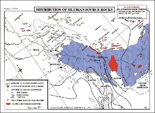