![]() Click to view article in PDF format.
Click to view article in PDF format.
The Middle Cretaceous to Early Miocene Petroleum System in the Zagros Domain of Iran and Its Prospect Evaluation*
By
M.L. Bordenave1
Search and Discovery Article #10040 (2003)
*Adapted from “extended abstract” of presentation at AAPG Annual Meeting, March 10-12, 2002, Houston, Texas.
1Consultant, 24 Avenue President Kennedy, 75016 Paris, France
An impressive gathering of giant fields, located in the 50,000 sq km Dezful Embayment, produces from the Asmari Limestone of early Miocene and from the Cenomanian Sarvak Limestone, and contains some 400 billion barrels of oil-in-place, or 7% of the oil global reserves.
Two excellent
![]() source
source![]() rocks are associated with these reservoirs, the Albian Kazhdumi Formation
and the middle Eocene Pabdeh Formation. The Kazhdumi was deposited in a
depression corresponding to the present Dezful Embayment, and probably extended
northeastward, while the Pabdeh accumulated in a NNW-SSE trough, from Shiraz to
Lurestan.
rocks are associated with these reservoirs, the Albian Kazhdumi Formation
and the middle Eocene Pabdeh Formation. The Kazhdumi was deposited in a
depression corresponding to the present Dezful Embayment, and probably extended
northeastward, while the Pabdeh accumulated in a NNW-SSE trough, from Shiraz to
Lurestan.
Modeling showed
that Kazhdumi and Pabdeh reached the onset of oil expulsion 1 to10 Ma, after the
beginning of the Zagros folding. Therefore, migration took place almost
vertically and was facilitated by intense fracturing in high-relief anticlines.
The distribution of ![]() source
source![]() rocks, thickness, characteristics, and maturity were
used to forecast if an undrilled structure is expected to be oil, gas, or
water-bearing and what would be the order of magnitude of the oil-in-place.
rocks, thickness, characteristics, and maturity were
used to forecast if an undrilled structure is expected to be oil, gas, or
water-bearing and what would be the order of magnitude of the oil-in-place.
In the Dezful Embayment, many low-relief Zagros anticlines, poorly defined by a poor-quality early seismic, remain to be drilled, after seismic confirmation. However, their fracturing, critical for limestone permeability, is expected to be less developed. N-S oriented pre-Zagros salt-related elongated structures, also fed by Kazhdumi or deeper sources, are prospective, especially for Zubair (Lower Cretaceous) and Burgan (Middle Cretaceous) sandstones. In addition, large anticlines remain to be drilled to the Middle Cretaceous Sarvak, north of the mountain front.
|
|
The Zagros Foothills, a system of large size whaleback asymmetric anticlines, formed as the result of a late Miocene to Pliocene orogeny, includes two uplifted areas, Lurestan to the north, where anticlines are deeply dissected, and Fars to the south. In between, a 50,000 sq km depressed area, known as the Dezful Embayment (Figure 1), corresponds to an impressive gathering of 45 oil fields, often associated with gas caps. Several of them are categorized as supergiants as they contain 10 to 50 billions barrels of oil-in-place; i.e., Agha Jari, Ahwaz, Bibi Hakimeh, Gachsaran, Mansuri, Marun, and Rag-e Safid. About 98% of the oil-in-place, namely 250 billions barrels of oil and more than 200 Tcf of associated gas are trapped in two reservoirs (Figure 2), the 300 to 500 m thick early Miocene high energy Asmari Limestone, which is extremely porous almost everywhere in the study area and well sealed by the efficient Gachsaran evaporites, and the Sarvak Limestone (Cenomanian and early Turonian), very thick, up to 1000 m, but porous only in some of the high-energy platform facies, capped by the thick Gurpi/Pabdeh marls. In most of the fields, which correspond to high-relief, asymmetric, often thrusted anticlines, the Asmari and Sarvak reservoirs are interconnected as the result of an intense fracturing of the Pabdeh-Gurpi marls in the crestal part of the anticlines.
Excellent
type IIs In spite of
their excellent characteristics (initial TOC values in the 5-15% range,
high Hydrogen Index (HI) varying from 500 to 700 g HC/kg C, and
thickness from 100 to 300 m), the contribution of each
At the end
of Aptian, a major regression, which caused the shallow-water Aptian
carbonates to become emergent, was followed by a low-amplitude
transgression marked by a sudden influx of clastics. Most of Saudi
Arabia, Kuwait, and Iraq, west of the Euphrates River, were covered by
alluvial plain facies, while deltaic sediments rapidly prograded in the
Safaniya-Burgan area. The more distal part of the basin was the locus
for the deposition of the Kazhdumi Formation, dated as Albian. A
depression was limited to the SE by the Fars Platform, where the
deposition of shallow-water thin oxic marls was interrupted by temporary
emergences. To the north, it was limited by the E-W Bala Rud carbonate
shoal, which separated the Kazhdumi Depression centered on the present
day Dezful Embayment from the Lurestan Depression. To the Up to 300 m
of dark grey marls and subordinate argillaceous limestone, containing a
pelagic fauna of Globigerina, Globotruncan, and radiolaria,
were deposited in strictly euxinic conditions. The organic matter is of
algal origin. Kazhdumi TOC values vary from 1 to 11%, with average
values in the 5% range in the center of the depression. The potential S2
may reach 50 to 60 g HC/kg During the Albian, the Arabian Platform was close to the Equator, according to plate tectonic reconstruction, and under a humid climate as shown by the large amount of fresh water which flowed into the Dezful Depression through a system of rivers (Bordenave and Burwood, 1995). This fluvial water, outwash from the Arabo-Nubian land mass, was nutrient-rich (nitrates and phosphates). Ideal conditions were realized for a high plankton productivity in the shallow low-density oxygenated fresh water. Density stratification and the fall of organic matter in the oxygen-deprived zone are a classical mechanism for anoxic conditions. Sulfate-reducing bacteria were extremely active, as demonstrated by the sulfur incorporated in the Kazhdumi organic matter. As a consequence of the aggradation of the former Radiolarite Trough to the Arabian Platform, during the Campanian, direct access of the Arabian Platform to the South Tethys ceased, and a thick sequence of flysch, containing radiolarite debris for the large part, accumulated in front of the newly emergent area, which was actively eroded. A well individualized NW-SE-trending depression, parallel to the Zagros Suture, extended from Fars to Lurestan, during the Paleocene-Eocene and even Oligocene in Lurestan (Figure 4). It was bordered to the SW by platform carbonates covering most of the Arabo-Persian Gulf. To the SE, the depression was limited by the Fars Platform, where the shallow-water dolomitic limestone of the Jahrum Formation surrounded a subsident sebkha (Sachun Formation). A monotonous and thick (200 to 1000 m) sequence of grey marls, containing a rich planktonic fauna of Globorotalia and Globigerina, was deposited. Euxinic conditions prevailed in the central part of the depression during middle/late Eocene and even early Oligocene in Lurestan. 150 to 200 m of organic-rich marls contain up to 11.5% organic carbon, the average TOC values varying from 3% in Fars to 7.5% in Lurestan (Figure 4). The organic matter is mostly algal (Tasmanacea), with HI up to 500/650 g HC/kg C; however, terrestrial influences are visible in the vicinity of the NE shoreline.
The Main
Fields area corresponds almost exactly to the depression where the
Kazhdumi Except
perhaps in the Pazanan field, no interference was observed between the
Asmari/Sarvak reservoirs and The IFP
Genex software was used to model the thermal evolution of the Kazhdumi
and the Pabdeh Modeling was performed for selected wells in almost each field in the Dezful Embayment and for virtual wells located on the flank of the anticlines, by adding slices of 1000 ft (304.8m) down to the synclinal axes. The thickness of the eroded sediments has been evaluated from a set of formation isopachs. One of the critical point remains; namely, the thickness estimate of the Gachsaran evaporites, as the Gachsaran and the overlying beds are unconformably folded and thrusted over the Asmari. If Karanj and Paris are excepted, the onset of oil expulsion from the Kazhdumi was reached when its base was buried to 3900 to 5000m, depending on locality, between 8 and 1Ma, in synclines as well as on anticlines. In Karanj and Paris, oil began to be expelled 16Ma. For the Pabdeh, the oil expulsion has not commenced yet on the Mansuri trend, even in the synclines. Elsewhere, it was not reached on the top of the Main Field anticlines, even at Karanj and Paris, but it was reached in the deeper part of some synclines, from present to 4.5 Ma. On the NE
edge of the platform, Burdigalian sediments (16 and 20 Ma) were
deposited before the Zagros folding (Ricou, 1974). In the Dezful
Embayment, the main phase of Zagros folding apparently began after the
deposition of the Mishan Formation (middle Miocene), and was witnessed
by the deposition of the Agha Jari molasse, some 10Ma. Except for the
Karanj and Paris fields, the oil expulsion, either on the anticlinal
tops or in the deeper parts of the synclines, commenced later than 8Ma;
i.e., after the beginning of the Zagros folding. It is likely that the
fracturing of the Sarvak to Asmari interval in the anticlinal part of
the high-relief structures facilitated the oil expulsion and its upward
migration to the first caprock encountered, the Gachsaran Formation. The
As the oil
expulsion from the The geometry of the areas of drainage was deduced from early seismic data, at the top of the Asmari, which is a well defined marker. Each area of drainage was cut into slices every 1000 feet. The surface of each slice was measured by planimetry. A burial profile was established for each slice to calculate, for both the Kazhdumi and the Pabdeh, the evolution of their transformation ratio (TR) through time, the present day TR, the amount of oil generated, and the amount expelled. The number of slices varied from 3 to 5 for the anticlines located on the SW Mansuri trend, to up to19 in high-relief anticlines, such as Naft-e Safid. Modeling was applied to 21 fields of the Dezful Embayment, which contain 86.5% of the oil-in-place found in the Zagros Domain. All together, 195 burial profiles were used. The initial
oil-in-place (IOIP) of each fields was compared to the oil expelled from
the As oil
migrated vertically from the Kazhdumi and the Pabdeh In Lurestan,
the Kazhdumi is not a In the Dezful Embayment, all the large high-relief anticlines were drilled to the Sarvak and deeper. A few anticlines of smaller size remain to be drilled to the Sarvak. Several low-relief prospects, evidenced by the early seismic, remain to be tested for the Asmari reservoir; however, they need detailed mapping from new seismic data. It should be noted that even if reservoir characteristics are generally good, the fracturing in low-relief anticlines is expected to be less developed, and the reservoir productivity to be lower. In addition, in the south of the Dezful Embayment, in areas not influenced by the Zagros folding, salt-related, large, N-S-elongated,very low-relief structures, formed sometimes as early as the beginning of the Jurassic, are prospective for the Sarvak and the Asmari Limestone/Ahwaz sands and for the Burgan and the Zubair sands. Again a good quality seismic is needed in this vast area. Some stratigraphic trap possibilities also exist, such as the pinch out of the Burgan sands; these developments are still in their infancy.
Bordenave, M.L., and Burwood, R., 1990,
Bordenave, M.L., and Burwood, R., 1995, The Albian
Kazhdumi Formation of the Dezful Embayment, Iran: one of the most
efficient petroleum generating systems, in Petroleum
Bordenave, M.L., and Huc, 1995, The Cretaceous James, G.A., and Wynd, J.G., 1965, Stratigraphic nomenclature of Iranian Oil Consortium Agreement Area, AAPG Bulletin, v. 49, p. 2182-2245. Ricou, 1974, L'étude géologique de la région de Neyriz (Zagros iranien) et l'évolution des Zagrides, Thesis, Université Paris-Sud, Orsay. 321p. |
 Figure 1.
Location map of the Middle
Figure 1.
Location map of the Middle 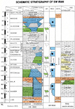 Figure 2.
Schematic stratigraphic chart of SW Iran, along with Iraq and Saudi
Arabia, with identification of
Figure 2.
Schematic stratigraphic chart of SW Iran, along with Iraq and Saudi
Arabia, with identification of 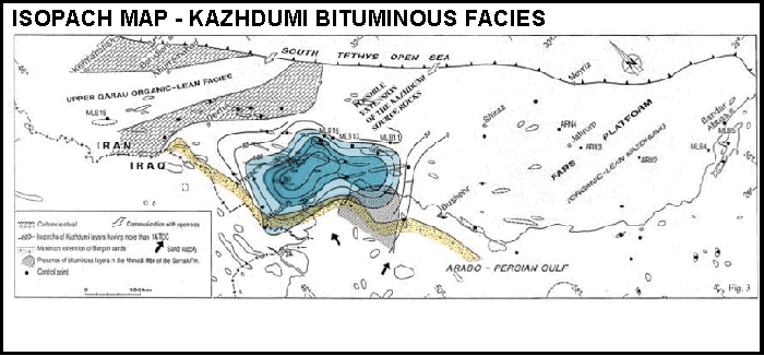