![]() Click to view images in PDF format.
Click to view images in PDF format.
SOME STRUCTURAL STYLES ON REFLECTION PROFILES FROM
OFFSHORE NIGER DELTA*
By
Deborah E. Ajakaiye1 and Albert W. Bally2
Search and Discovery Article #10031 (2002)
*Excerpts adapted for online presentation from an AAPG Special Publication, entitled Course Manual and Atlas of Structural Styles from the Niger Delta by the authors. This publication is AAPG Continuing Education Course Note Series #41, which is available for sale from AAPG Bookstore (www.aapg.org).
1University of Houston, Houston, Texas ([email protected])
2Rice University, Houston, Texas ([email protected])
General Statement
The Niger Delta (Figure 1) is considered one of the most prolific hydrocarbon provinces in the world. Estimates of the ultimate recoverable hydrocarbons from this basin, which is at least 12 km thick in its central part, are 35 BBO of oil and 120 tcf of gas (Ekweozor and Daukoru, 1994), giving it one of the highest global concentrations of petroleum per unit volume of basin fill.
Nigeria has an abundance of excellent seismic reflection profiles of both onshore and offshore parts of the Niger Delta. In the course manual and atlas (Continuing Education Course Note Series #41), structural styles in the Niger Delta are differentiated, classified, and illustrated with seismic profiles compiled from regional data. This documentation provides a realistic context for earth science education in universities and the oil industry, especially in Nigeria and in other coastal countries of Africa.
In this article two of the seismic profiles, with corresponding line drawing, illustrate a number of structural styles in the Niger Delta, ranging from growth faults to thrust faults and folds associated with each. The Niger Delta is representative of a major delta, the evolution of which is best described as a delicate balance in which sediment loads deform an underlying unstable substratum, and the structures so formed influence subsequent patterns of sedimentation (e.g., Knox and Omatsola, 1989; Doust and Omatsola, 1989; Reijers et al., 1997). The Niger and other major deltaic regions, such as the Texas and Louisiana elements of the Gulf of Mexico basin (e.g., Worrall and Snelson, 1989; Galloway et al., 1991; Weimer and Buffler, 1992), show structural evolution controlled by large prograding deltaic depocenters that have been deposited on overpressured prodelta shales and/or salt. Both the Gulf of Mexico and the Niger Delta have extensive gravity-driven decollement fold belts, which are of a distinctive non-orogenic character. Comparisons of the Niger Delta with the Gulf Coast have been made by Morley and Guerin (1996), and Wu and Bally (2000).
|
uDeformed eastern offshore Niger Delta t-Graben / landward-dipping fault
uDeformed eastern offshore Niger Delta t-Graben / landward-dipping fault
uDeformed eastern offshore Niger Delta t-Graben / landward-dipping fault
uDeformed eastern offshore Niger Delta t-Graben / landward-dipping fault
uDeformed eastern offshore Niger Delta t-Graben / landward-dipping fault
uDeformed eastern offshore Niger Delta t-Graben / landward-dipping fault
|
Click here for overlay of part of line drawing (Figure 2) onto Figure 3.
Click here for line drawing (Figure 2) with both seismic profiles (Figures 3 and 4).
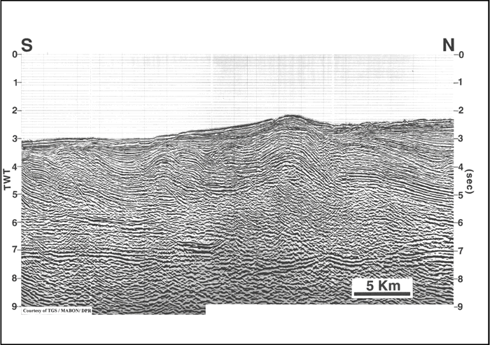
COMMENTS ON STRATIGRAPHYThe line drawing (Figure 2) provides a crude identification and correlation of events based on the very limited well control (well logs, synthetic seismograms, and paleontology) that was available to us. Correspondingly, we have differentiated, from bottom to top, the levels described below. "Basement" event is commonly poorly defined. In the northwestern portion of the offshore Niger Delta, the "basement" event is the inferred top of the oceanic basement, whereas in the more landward portions of the delta, the event probably corresponds to the top of the crystalline Precambrian basement that crops out in the onshore areas of Nigeria. The "near top Cretaceous" event, which is inferred to be present, is carried as a "phantom" horizon under the deeper portion of the offshore Niger Delta. The near "Top Miocene" and near "Mid Pliocene" events are crude correlations based on the very limited well control available to us. Seismic sequence stratigraphy is also a very important component of the analysis of deltaic depocenters. Even with the very sparse well control, our seismic profiles permit recognition of some significant stratal configurations, such as unconformities (i.e., sequence boundaries), prograding and aggrading systems, and other sequence stratigraphic features. DEFORMED EASTERN OFFSHORE NIGER DELTA The offshore Eastern Niger Delta displays seismic characteristics typical of the delta. In shallow waters with depths less than 400m, the dominant features here are well developed extensional growth faults and rollovers (Figure 2). Intense folding of the sediments and thrust faults are prominent features in this part of the Niger Delta where translational and compressional structures are well developed due to rapid sediment influx and consequent gravity tectonics (Figure 2). Some of these features include impressive lateral ramp of compressional structure involving Miocene - middle Pliocene formations. Unlike in the western segment of the Niger Delta, contractional tectonics that balances proximal extension and downdip translation of the overburden are present at relatively shallow depths of about 300m (Figure 2). Prominent compressional features are thrust faults and shale diapirs. Thick Tertiary folded beds overlie a relatively undeformed substratum.
Marine shales deposited since Late Cretaceous underlie the entire Niger Delta
(e.g., Lehner and de Ruiter, 1977; Doust and Omatsola, 1989) The shales have
been overpressured and squeezed farther seaward, forming large ridges and
diapirs due to the rather rapid deposition of sediments in the Niger Delta since
the Eocene. These shale diapirs are widely distributed in the offshore Niger
Delta. The plasticity of the shales is mainly due to their being "undercompacted"
as a result of the fast rate of deposition, burial thickness, and absence of
evacuation drainage. This undercompaction not only causes a lowering of the
density by as much as 40% of that normally associated with compacted shale but
also gives rise to a
Graben Dominated by Landward-Dipping Fault (Figure 3) In response to the rapid sediment influx from the River Niger and the Cross River and their tributaries, growth faulting and a series of east-west-trending depocenters characterize the Miocene-Recent structure of the delta. Figure 3, from northern part of the dip Seismic Profile D6B (Figure 2) in the eastern portion of the Niger Delta, best illustrates the typical extensional features (mainly growth faults) and principal types of oil field structures in the Niger Delta, such as collapsed crest structures discussed in Weber and Daukoru (1975) and Doust and Omatsola (1989). Folded beds beneath the “collapsed crest structure” at the northern end of the section (Figure 3) overlie major faults dipping in opposite directions (N and S) at either ends of the profile. These rollover structures associated with growth faults are the dominant trapping mechanism in the Niger Delta. The growth faults may also function as hydrocarbon migration paths (Chatellier and Slevin, 1989) from the underlying shaly formation to the overlying sandstones. Deeper shale masses underlying these major master faults. Also, the poorly defined lower reflection is relatively flat-lying. Figure 4 is the southern part of Profile D6A located in deep water in the eastern part of the Niger Delta, where the water depth ranges from about 1700 to over 2300 meters. Well developed compressional structures are developed at the toe of the Niger Delta growth fault system. Intense folding of the sediments and thrust faults are prominent features in this part of the Niger Delta (Figures 2 and 4). At about 6 seconds, an upper folded domain is separated from a lower flat domain. The base of the folded domain defines the decollement level from which the thrust faults emanate. Especially in the southern part of the profile, this level is higher than the "near Top Cretaceous" boundary, which is also flat-lying (Figures 2 and 4). In the central part of the profile is a deformed shale mass, which is associated with the toe thrusts typical of the central portion of the Niger Delta. Shortening in the toe thrusts, results from seaward movement of depocenters; this increases as the delta progrades from north to south. Relief of the sea floor, shown in Figures 2 and 4, is due to young folding of the underlying sediments. The relatively flat “basement,” at about 7 to 7.5 seconds, is identified by the end of strong reflection character at the base of the section. The folds and thrusts in the overlying sediments are detached from the basement. Most of the folds are pre-mid-Pliocene, although the fold associated with the relief of the sea floor deforms the base of the youngest sequence. This same fold appears to show a bottom (sinuating) reflector that may be associated with hydrates (Figure 4).
REFERENCESChatellier, J-Y., and A. Slevin, 1988, Review of African petroleum and gas deposits: Journal of African Earth Sciences, v. 7, no. 3, p. 561-578. Doust, H., and E. Omatsola, 1989, Niger Delta, in Divergent passive margin basins, J.D. Edwards and P.A. Santogrossi, eds., AAPG Memoir 48, 201-238. Ekweozor, C.M., and E.M. Daukoru, 1994, Northern delta depobelt portion of the Akata-Agbada(!) petroleum system, Niger Delta, Nigeria, in The Petroleum system—from source to trap: AAPG Memoir 60, p. 599-613. Galloway, W.E., D.G. Bebout, W.L. Fisher, J.B. Dunlap, Jr., R. Cabrera-Castro, J.E. Lugo-Rivera, and T.M. Scott, 1991, Cenozoic, in A. Salvador, ed., The Gulf of Mexico Basin: Geological Society of America, The Geology of North America, v. J, p. 245-324. Knox, G. J., and E. M. Omatsola, 1989, Development of the Cenozoic Niger delta in terms of the "escalator regression" model and impact on hydrocarbon distribution, in W. J. M. van der Linden et al., eds, 1987, Proceedings, KNGMG Symposium on Coastal Lowlands, Geology, and Geotechnology: Dordrecht, Klumer Academic Publishers, p. 181-202. Lehner, P., and P.A.C. de Ruiter, 1977, Structure history of the Atlantic margin of Africa:AAPG Bulletin, v. 61, p. 961-981. Morley, C.K., and G. Guerin, 1996, Comparison of gravity-driven deformation styles and behavior associated with mobile shales and salts: Tectonics, v. 15, p. 1154-1170. Reijers, T.J.A., S.W. Petters, and C.S. Nwajide, 1997, The Niger Delta Basin. African Basins, in Sedimentary basins of the world, v.3, R.C. Selley, ed., p. 151-172. Weber, K.J., and E.M. Daukoru, 1975, Petroleum geology of the Niger delta: 9th World Petroleum Congress Proceedings, v. 2, p. 209-221. Weimer, P. and Buffler, R.T., 1992, Structural geology and evolution of the Mississippi Fan Fold Belt, deep Gulf of Mexico: AAPG Bulletin, v. 76, no. 2, p 225-251. Worrall, D.M., and S. Snelson, 1989, Evolution of the northern Gulf of Mexico Basin, with emphasis on Cenozoic growth faulting and the role of salt, in A.W. Bally and A.R. Palmer, eds., The Geology of North America-an overview: Geological Society of America, p. 97-138 Wu, S., and A.W. Bally, 2000, Slope tectonics - Comparisons and contrasts of structural styles of salt and shale tectonics of the Northern Gulf of Mexico with shale tectonics of Offshore Nigeria in Gulf of Guinea, in W. Mohriak, and M. Talwani, eds.: Geophysical Monograph 115, American Geophysical Union, p. 151-172. ACKNOWLEDGMENTAAPG Continuing Education Course Note Series #41, as well as these excerpts from it, would not have been possible without the generous and enthusiastic support of the following organizations and individuals working for them, to which we are greatly indebted: The Federal Ministry of Petroleum Resources wisely recognized the great need to make these data available to young Nigerian students and authorized the great majority of profiles in this manual be generously made available by TGS Calibre Geophysical company International and Mabon Nigeria Ltd. We are particularly grateful for the help and support of Mr. D. Worthington and Mr. E. "Woody" Hartman of TGS and Mr. Mabon Madubunyi of Mabon Nigeria Limited. The Ministry also kindly gave permission to publish these profiles. Additional seismic profiles were made available for the study by the following whom we would like to thank: CHEVRON Nigeria Limited - especially Messrs. S.O. Ariyo and A.O. Akinpelu - (former General Manager Exploration and current Exploration Manager, respectively). MOBIL Producing Nigeria Limited - Mr. Paul Caldwell, Jr. (former Managing Director) and Mr. Jide Agbabiaka (Exploration Manager). ELF Nigeria Limited. ASHLAND Nigeria Limited - Dr. Kirk R. Geno (Exploration Advisor). TEXACO - Mr. Olabode T. Faleye, Dr. O.O. Phillips, and Mr. Michael W. Hoffman. BP/STATOIL Nigeria Limited - Dr. Forbes Mclean. AMOCO Production Nigeria Limited - Ms. Katrina Coterill. AGIP Nigeria Oil Co. Ltd. - Mr. Femi Akinmade (Manager Exploration Department). We also wish to acknowledge with great appreciation the technical input and very kind support of Dr. Kevin Burke of the University of Houston, Texas, USA, and the support of Dr. Jim Granath. |
 Figure 1. Index map
(after Doust and Omatsola, 1989) of Niger Delta and offshore Nigeria, showing the location of
regional Seismic Profile D6. Line drawing of it is
Figure 1. Index map
(after Doust and Omatsola, 1989) of Niger Delta and offshore Nigeria, showing the location of
regional Seismic Profile D6. Line drawing of it is