![]() Click to view images in PDF format.
Click to view images in PDF format.
Animation Model of West Central South America from the Early Jurassic to Late Miocene, with Some Oil and Gas Implications*
Terry Li Arcuri1 and George H Brimhall2
Search and Discovery Article #10033 (2002)
1 1826 Alray Drive, Concord, CA 94519 ([email protected])
2 Department of Earth and Planetary Science, University of California, Berkeley, CA 94720
A model has been constructed from stratigraphic analysis and magmatic emplacement data in which variations of the sedimentary environments of northern Chile and Argentina from Early Jurassic to late Miocene were compiled (206 Ma to 10 Ma). From these data a series of maps at 2 million year intervals have been constructed and used to complete an animation depicting the evolution of the regional sedimentary and magmatic systems. In this animation, tectonic influences which caused compression and generated uplift as well as eustatic and regional sea level fluctuations can be observed in the changing sedimentary environments.
During evolution of the
region, numerous marine transgressive and regressive events occurred
causing variations in the lithologies and sediment thickness. Also apparent from
the magmatic emplacement ages is the eastward migration of the magmatic arc from
the west coast in Early Jurassic to the present location on the border of Chile
and Argentina. Jurassic marine transgressions entering from the west caused the
magmatic arc to become separated from the coast of South America by the narrow,
marine, back-arc Domeyko basin. Regressions to the west tended to isolate
smaller sub-basins, which display distinct sedimentary histories recorded during
the regressive intervals. Cretaceous rifting coupled with a marine transgression
led to the deposition of large quantities of marine shales in the Salta basin of
northern Argentina and also in southern Bolivia. The marine shale deposited in
these regions would later become source rocks for identified ![]() petroleum
petroleum![]() reserves
in central South America. Major continental compression and uplift events
through the Tertiary led to the formation of the Bolivian altiplano. Thick
deposits of sediments shed during this uplift were deposited in basins near
active uplift areas, burying
reserves
in central South America. Major continental compression and uplift events
through the Tertiary led to the formation of the Bolivian altiplano. Thick
deposits of sediments shed during this uplift were deposited in basins near
active uplift areas, burying ![]() petroleum
petroleum![]() source rocks, potentially resulting in
the generation of hydrocarbons. To date, the Bolivian Altiplano region is a
nonproductive hydrocarbon province.
source rocks, potentially resulting in
the generation of hydrocarbons. To date, the Bolivian Altiplano region is a
nonproductive hydrocarbon province.
The construction of sedimentary and magmatic environment maps has led to better understanding of the evolution of northern Chile, Bolivia, and Argentina. In particular, they can be used in the examination of depositional environments present in local areas for particular time intervals. These observations can assist in the geological interpretation of a region for hydrocarbon potential by showing the sedimentary depositional variations through numerous environments and any later magmatic interactions. With this new insight, productive and nonproductive hydrocarbon provinces can be related back through time to the deposition of source rocks, their structural evolution, and thermal maturation histories.
|
|
Figure Captions
Click here to view sequence of Figure 5A, 5B, and 5C. Click here to view sequence of Figure 6A, 6B, and 6C. Click here to view sequence of Figure 7A, 7B, and 7C.
AnimationThe accompanying animation (composed of geologic time-slice maps of Jurassic-Tertiary facies/lithologies, with calibrated sea-level curve) is in a .GIF format and is designed to have a run time of approximately 5 minutes. Pertinent geological events are described by text messages during which, the geological time within the model is paused. Highlighted zone in yellow progresses up the regional/eustatic sea-level curve with the current time interval displayed on the right.If problems are experienced in viewing this animation (due to file size), please download it to hard drive for offline viewing. To download, right mouse-click on link (to Animation) and select "Save Target As...;" then provide location for download and designate as new file (if desired).
IntroductionThe migration of magmatism, tectonic deformation, and changes in the distribution of sedimentary environments were all major influences in the geological evolution of the South American cordillera. All of these processes are linked in an action-reaction manner, such as the sedimentary response to tectonic uplift. In order to investigate the geological evolution of this region with a focus on the occurrence and maturation of hydrocarbons, a deconstruction of the sedimentary, tectonic, and magmatic events by both time and space has been preformed to generate a dynamic visualization animation model. The evolution of the Andean magmatic arc has been the subject of numerous investigations regarding its emplacement and migration (Petersen, 1999; Sillitoe and KcKee, 1996) and the relationship between subduction and magmatism (Kay et al., 1999; Kay and Mpodozis, 2001). Similarly, studies have been conducted investigating the structural development of the Andes (Hartley et al., 2000; Mon and Salfity, 1995; Reutter et al., 1988) and the sedimentology and stratigraphy of specific regions (Ardill et al., 1998; Gröschke et al., 1988; Harrington, 1961; Prinz et al., 1994; Von Hillebrandt et al., 1986). This study incorporates all of these styles of data to investigate the geological evolution of the northern Chile, Argentina, and southern Bolivia as a whole with a focus on hydrocarbon resources. The region investigated in this study ranges from 20° to 28°S and from 65° to 71°W (Figure 1) from Early Jurassic, 206 Ma, through late Miocene, 10 Ma.
The animation model was constructed from
stratigraphic, sedimentologic, and magmatic emplacement data through
which variations in the sedimentary and magmatic environments of
northern Chile and Argentina could be determined. Palinspastic
paleogeographic regional maps by Pindell and Tabbutt (1995) were used to
delineate the region to be investigated (Figure 1).
During Oxfordian in the Jurassic (159 to 154
Ma) the linear, north-south-trending Domeyko sedimentary basin was
actively accumulating sediments, and within this basin, individual
depocenters show sediment thickness variations during this 5 million
year interval (Figure 2) (Prinz, 1986). Sediment thickness variations
were caused by basin-bounding and basin-intersecting structures which
were active during sediment accumulation. Many structures continued to
be active throughout the Jurassic and effectively constrain sediment
lithologies and their distributions in the model. The maps from
Pindell and Tabbutt (1995) and Prinz (1986) do not distinguish between
the various sedimentary lithologies deposited nor do they indicate the
location and timing of magmatic emplacements. The lack of temporal
resolution of the various sedimentary environments to intervals smaller
than 20 million years obscured subtle yet important factors in the
evolution of sedimentary environments and in the possible generation of
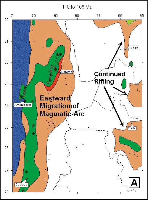
Data CollectionTo generate the animation model, data were collected from field observations, mapping, published stratigraphic columns, geological maps, lithologic facies maps, magmatic emplacement ages, volcanic ash ages, and mineralization ages. Extrapolation between data points and interpolations through time were performed using a lithofacies transition model developed for this project. Sediment distributions were depicted with no attempt to reconstruct original basin geometry prior to deformations associated with faulting, compression, rifting, or uplift of the Andean cordillera. The facies transition model used for this project was based on several simplifying assumptions: 1) sediment is transported down-gradient, 2) grain size decreases with increasing distance from the source, 3) erosion is a continuous process on exposed bedrock, and 4) carbonate deposition is suppressed in environments with high siliciclastic input. Using these assumptions, a continental lithologic sequence of conglomerate-sandstone-siltstone-shale (Figure 3A) and a marine sequence of carbonate-shale was developed (Figure 3B). It was assumed that all lithologies with a finer grain size than the lithology described for a specific data point would be encountered with increasing distance from that point, down-gradient. For example, we infer a transition from a data point of conglomerate to sandstone, siltstone, and finally to shale with increasing distance down-slope. Multiple points of similar lithology were grouped into fields and lithologic homogeneity was assumed. This model allowed the authors to extrapolate between data points and through time to generate sedimentary environment lithofacies maps for the entire study region. Published maps depicting large-scale events such as marine transgressions and regressions allowed for sedimentary systems to be correlated to regional and continental scales (Marquillas and Salfity, 1988; Pindell and Tabbutt, 1995). The constructed maps depict marine sedimentary, continental (nonmarine) sedimentary, and magmatic environments as well as areas experiencing erosion or nondeposition from 206 Ma through 10 Ma. Sediment isopach maps (e.g., Figure 2) (Prinz et al., 1994) and fault compilation maps were used to constrain the boundaries between sedimentary environments and surrounding erosional areas. Individual map images at a two-million-year interval were generated in Canvas 6.0 and compiled into the final animation using GIF Animator 4.0 software from Ulead Systems. The lithofacies maps and the final animation were generated as part of the doctoral thesis of Terry Arcuri using computer facilities in the Earth Resources Center at the University of California, Berkeley. Geological EvolutionThe geological evolution of the study area shows regional- and continental-scale processes that influenced the type and distribution of lithologies deposited from Early Jurassic to late Miocene. The completed model shows the effect of numerous marine transgressive and regressive events affecting the continent, with four Jurassic and one Cretaceous eustatic-driven transgressive events at 206 Ma, 190 Ma, 176 Ma, 168 Ma, and 80 Ma and one regional tectonic transgression at 151 Ma (Ardill et al., 1994). Figure 4 shows the eustatic and regional sea-level curves from the Jurassic to the present for northern South America (Haq et al., 1987; Ardill et al., 1998). All changes are measured relative to modern sea level, with long-term sea-level variations in red and short term fluctuation in blue. Arrows indicating shaded sections of the relative sea-level curve (Figure 4) label time intervals depicted in later lithofacies maps (Figures 5, 6, and 7). Marine transgressions correspond to negative slopes (inflections to the left) and regressions have positive slopes (inflections to the right) of the curves in Figure 4. Lithologic variations demonstrate global- and continental-scale active tectonic processes, such as continental rifting, the onset of Andean uplift, and the formation of the Bolivian altiplano by depicting the accumulation of conglomerates in basins near tectonically active zones. Also apparent from the magmatic emplacement ages is the eastward migration of the magmatic arc from the west coast in Early Jurassic to its present location on the border between Chile and Argentina (Sillitoe and KcKee, 1996; Petersen, 1999). The magmatic migration was also responsible for changes in the lithologies deposited in many of the regional sedimentary basins. In the completed model, we depict a progression of lithofacies maps from the Jurassic to late Miocene (206 to 10 Ma) in 2 million year increments. Selected time intervals are presented for discussion in the text for the Jurassic (Figure 5), the Cretaceous (Figure 6) and the Tertiary periods (Figure 7).
The Jurassic sediments of northern Chile have been the subject of studies examining their genesis and the development of the environment in which they were deposited (Ardill et al., 1994, 1998; Gröschke et al., 1988; Harrington, 1961; Prinz, 1986; Von Hillebrandt et al., 1986). The tectonic history of the region has also been the focus of works investigating the connection between sediment thickness and forearc development (Hartley et al., 2000) and sub-basin evolution (Prinz et al., 1994). The conclusions from these works indicate the Jurassic System consisted of a marine back-arc basin through central Chile which experienced numerous transgressive-regressive events prior to its disappearance in Late Jurassic to Early Cretaceous (Prinz et al., 1994; Ardill et al., 1998). Five major Jurassic transgressions entered from the west at 206 Ma, 190 Ma, 176 Ma, 168 Ma, and 151 Ma and caused the magmatic arc to become separated from the coast of South America by the narrow, marine, back-arc Domeyko basin (Figure 5A). Intervening marine regressions at 197, 182, 170, and 155 Ma isolated sub-basins, which display distinct sedimentary histories recorded during the regressive sediment intervals (Figure 5B). Four of the marine transgressions (206, 190, 176, and 168 Ma) and three of the regressions (197, 182, and 170) correlate with eustatic sea-level changes seen in Figure 4 (Ardill et al., 1998). The regressive-transgressive marine sequence at 158-153 Ma is a regional tectonic effect on sea level caused by regional faulting and local basin accommodation. Tracking the specific lithologic variations through these basins and over the continent as a whole shows how magmatic and tectonic processes act in concert to influence sedimentary environments. Figure 5 shows several time intervals from the Jurassic in which the focus is the marine back-arc Domeyko basin. Figure 5A depicts the basin with strong connections to the ocean and a large area of distribution. As the basin was isolated from the ocean by a marine regression and the development of the coastal magmatic arc (Figure 5B), evaporite minerals, such as gypsum and halite, precipitated in various sub-basins. They were deposited within the basin at various times throughout Jurassic, culminating in the massive, basin-wide deposition of the Millonaria Evaporite Formation in late Oxfordian (154 Ma), when the basin experienced extreme evaporative concentration (Ardill et al., 1998; Prinz et al., 1994). In Figure 5C the back-arc basin has nearly vanished, with only small sub-basin remaining. These sub-basins continued to receive sediments in what was originally the deepest part of the original basin.
Many occurrences of thick deposits of deep
marine shales have been described in the Domeyko basin. These shale
deposits of the Caracoles Formation do not appear to have generated
substantial Continental scale processes continued to make major changes throughout the study region during the Cretaceous period. Of these processes, continental rifting (Figure 6A and 6B) and rifting coupled with a marine transgression from the east were the most notable (Figure 6C). Eustatic sea level curves reached a maximum height in the middle Cretaceous at approximately 90 Ma (Figure 4) corresponding to the major transgressive flooding seen in the study area (Haq et al., 1987; Marquillas and Salfity, 1988). Marine basins developed in northern Argentina and central Bolivia in which large quantities of marine shale were deposited. These shales would later become the source of much oil and gas in a productive sedimentary province (St. John, 1984).
Continental rifting began in Early
Cretaceous which allowed transgressing marine waters to penetrate far
into the continental interior (Marquillas and Salfity, 1988; Pindell and
Tabbutt, 1994; Reutter et al., 1988). Figure 6A shows the well developed
rift system through Argentina and Bolivia at 110 Ma. Distinct,
fault-bounded basins were established at this time, and continued to be
active into the Tertiary. This rift continued to expand, allowing a
marine transgression at 90 Ma to flood much of the continent (Figure
6B), reaching a maximum flooding surface at approximately 70 Ma (Figure
6C). In Figure
6C (Maastrichtian age), northern Chile and Argentina are
shown at the end of a continental rifting stage, with the sedimentary
lithologies and their distributions as a direct response to this
eustatic-driven marine transgression (Figure 4). Marine shale deposited
in the Salta basin would later become source rocks for The first phase of the eastward migration of the magmatic arc began in Early Cretaceous (~110 Ma) (Figure 6A) and by 90 Ma reached the location in the central portion of Chile (Figure 6B), where it would be located until mid-Tertiary (Scheuber et al., 1994; Petersen, 1999). The magmatic migration from the coast inland is associated with the change from oblique to perpendicular subduction, an increase in the convergence rate (from 5 to 15 cm/a) as well as a shallowing angle of the subducting slab (Scheuber et al., 1994; Jaillard and Soler, 1996). The change in the angle of subduction was responsible for initiating the Peruvian uplift phase (~90 Ma) which affected all of northern Chile and extended into western Bolivia and Argentina. Compressional events associated with the active subduction zone to the west and extensional tectonics throughout Argentina and Bolivia reactivated Paleozoic faults and allowed for the thick accumulation of sediments in basins which would later be uplifted to form the Bolivian Altiplano (Welsink et al., 1995). Burial metamorphism of marine shales through the Altiplano region seemingly did not generate any significant hydrocarbons, for this region is classified as a nonproductive province (St. John, 1984).
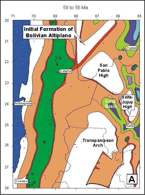
Tertiary regional evolution was dominated by compressional tectonics, continued eastward migration of the magmatic arc, and the formation of the Bolivian Altiplano (Figures 7A, 7B, and 7C). Andean uplift occurred in four major episodes during the Tertiary (~38 Ma, 23-25 Ma, ~10 Ma, and 3-5 Ma); these led to the deposition of large quantities of siliciclastic sediments, such as the Atacama gravel deposits of northern Chile. Marine sediments were not being deposited in the study area after early Eocene (~52 Ma), at which time erosion of uplifting regions became the dominant geological process. Magmatic evolution saw the rapid migration of the magmatic arc from its Cretaceous location through central Chile to the modern location at the border with Argentina and Bolivia. The eastward migration of the magmatic arc is linked to the shallowing angle of the subducting Nazca slab beneath the South American continent through the Tertiary (Scheuber et al., 1994). Two of the major tectonic events which occurred during Late Tertiary were the uplift of the Andes and the formation of the Bolivian Altiplano (Fig. 7A to 7C). The orogeny commenced in late Eocene and continued well into the Miocene in a series of uplift phases, the Incaica (~38 Ma), the Pehuenche (23-25 Ma), the Quechua (~10 Ma), and most recently the Diaguita (3-5 Ma) (Hartley et al., 2000). Figure 7B shows large fields of conglomerates that were shed from the regions of magmatic emplacements associated with the onset of Andean uplift during the Incaica phase. The large region without sediments in western Bolivia is the emerging Bolivian Altiplano, which began to form in Early Tertiary at approximately ~58 Ma (Figure 7A) (Welsink et al., 1995). Sediment accumulations in the Tertiary were dominated by the siliciclastic sediments, resulting from the uplift and formation of the Andes and the Bolivian Altiplano. These thick deposits of siliciclastic sediments were responsible for the diagenesis (organic metamorphism) which acted to generate much of the hydrocarbons in northern Argentina and central Bolivia (Baby et al., 1995; 1985; Mon and Salfity, 1995; Pindell and Tabbutt, 1994; St. John, et al., 1984; Welsink et al., 1995). Small deposits of localized evaporite lithologies were precipitated from remnants of the Cretaceous transgressive marine waters trapped in eastern Chile and northwestern Argentina (Figure 7A and 7B). Deposition of evaporites persisted from late Eocene to the present, with modern salars such as the Salar de Atacama exemplifying these deposits (Figure 7A, 7B, and 7C). By late Miocene, major evaporite deposits formed in western Chile between Tocopilla and Calama, running parallel to the coast (Figure 7C). These deposits are the source of much of the non-metallic mineral wealth of Chile, including nitrates, sulfates, and borates (Goerler and Wilkes, 1991; Lieben et al., 1994; Naranjo and Paskoff, 1981; Suarez and Bell, 1987, Vila, 1986, 1985). Eustatic sea level curves indicate two major sea-level lowerings associated with global cooling events at ~30 Ma and ~12 Ma as well as numerous smaller fluctuations from Oligocene to middle Miocene (Figure 4). These events correlate with the climatic shift from semiarid to hyperarid in middle Miocene, causing the general desertification of continental South America. ConclusionsThe construction of sedimentary and magmatic lithofacies maps and their compilation into an animation has allowed visualization of the evolution of sedimentary and magmatic environments present at specific locations of northern Chile, Argentina, and southern Bolivia for particular time intervals. Temporal evolution of multiple sedimentary environments can be observed and linked to eustatic and regional sea-level fluctuations as well as to global tectonic influences generating uplift and compressional events. This information can be used to examine the evolution and maturation of the various productive and nonproductive hydrocarbon regions in the study area. Jurassic evolution of the study region was dominated by the development and evolution of the Domeyko back-arc basin. Shallow-marine sediments of the Caracoles Group were deposited throughout this basin that was separated from the ocean by coastal volcanic rocks. The sediments deposited within this basin reflect a series of four eustatic marine transgressive events at 206 Ma, 190 Ma, 176 Ma, and 168 Ma, and one regional tectonic transgression at 151 Ma. Three eustatic regressive events at 197 Ma, 182 Ma, and 170 Ma, and one regional tectonic regression at 155 Ma separated these transgressions. The final marine regression at 155 Ma was responsible for isolating multiple sub-basins in which the contained seawater evaporated and led to the deposition of massive evaporite sequences of the Millionaria Formation. During the Cretaceous, sedimentary and magmatic variations occurred which were consequences of changes in the obliqueness and rate of subduction of the Nazca plate beneath the South American plate. The eastward migration of the magmatic arc commenced at ~110 Ma and signified a shallowing angle of eastward subduction of the Nazca plate beneath the South American plate. This shallowing subduction angle also caused back-arc spreading and rifting in central Argentina and Bolivia. As rifting developed, a series of interconnected basins, a marine transgression at 80 Ma flooded major portions of Bolivia and northwestern Argentina. Deposition of marine shales in the Salta basin of Argentina and in the rift basin near Tupiza, Bolivia, would later become hydrocarbon source rocks. A subsequent marine regression at 68 Ma isolated sub-basins which underwent evaporation and eventual deposition of evaporite minerals in Early Tertiary. Tertiary was dominated by four major compressional uplift events at 58 Ma, 38 Ma, 25-23 Ma, and ~10 Ma, and also the continued eastward migration of the magmatic arc. Compression and uplift at ~58 Ma was responsible for the initiation of the formation of the Bolivian Altiplano, which continued to be uplifted and to shed sediments throughout the Tertiary. Thick sediments buried Cretaceous marine sediments and generated conditions favorable for the generation of hydrocarbons. Magmatic emplacement sites migrated eastward from their position in central Chile at the Cretaceous-Tertiary boundary (65 Ma) to a position near modern-day locations at the Chilean-Argentinean and Chilean-Bolivian borders by late Miocene (10 Ma). It is thought that some of these magmatic emplacements provided thermal conditions within the windows for generation of oil and gas from organic-rich marine sediments.
Numerous global cooling
events between 38 Ma and 10 Ma were responsible for the overall
desiccation of western Chile, preserving fossil landscapes to modern
times. The onset of hyperarid climatic conditions in the middle
Miocene led to the formation of many South American evaporite deposits.
Nitrate and sulfate deposits of the northern Atacama desert, yielding
much wealth for Chile, formed in response to the Tertiary climatic
conditions of the region. Spatial and temporal visualizations such as
the one in the presented model allow for understanding of the
interactions between specific magmatic and sedimentary systems to be
investigated. Moreover, these interactions and the formation of various
lithologies can be directly related to the eustatic sea-level changes,
plate subduction, and continental-scale tectonics, which act in concert
to shape the
AcknowledgmentsThe authors would like to express appreciation to the following people; Irene Montero S. and Tina Takagi for discussions leading to improvements in the presentation of this material. This project was completed during doctoral research of Terry Arcuri, performed at the Earth Resources Center, University of California, Berkeley and made possible by a generous grant from the Exploration Division of Codelco, Chile. Ardill, J., G. Chong, and S. Flint, 1994, High resolution sequence stratagraphic analysis of the Mesozoic Domeyko basin, northern Chile: 7 Congreso Geologico Chileno; Actas, v. 1, p. 393-396.
Baby, P., I. Moretti, B. Guillier, R. Limachi, E. Mendez,
J. Oller, and M. Specht, 1995, Gröschke, M., A. Von Hillebrandt, P. Prinz, L. A. Quinzio, and H. G. Wilke, 1988, Marine mesozoic paleogeography in northern Chile between 21°- 26° S: in H. Bahlburg, C. Breitkreuz, and P. Giese, eds., The Southern Central Andes, Lecture notes in earth sciences 17, Springer, p. 105-117. Goerler, K., and E. Wilkes, 1991, Cordillera de la Sal/Salar de Atacama; an Oligocene to Recent record of continental evaporite sedimentation in northern Chile: Sedimentary and Paleolimnological Records of Saline Lakes. Haq, B., U., J. Hardenbol, and P. R. Vail, 1987, Chronology of fluctuating sea levels since the Triassic: Science, v. 235, p. 1156-1167.
Harrington, H., 1961,
Hartley, A. J., G. May, G. Chong, P.
Turner, S. J. Kape, and E. J. Jolley, 2000, Development of a continental
forarc: A Cenozoic example from the Central Andes, northern Chile:
Jensen I., and L. Oscar, 1985, Potencial petrolifero del Mesozoico marino en la Cuenca de Atacama; consideraciones en relacion a su historia de subsidencia, evolucion geotermica y posibilidades generativas: Actas-Congreso Geologico Chileno, v. 4, p. 3.651-3.673. Jaillard, E., and Soler, P., 1996, Cretaceous to early Paleogene tectonic evolution of the northern central Andes (0-18°S) and its relations to geodynamics: Tectonophysics, v. 259, p. 41-53. Kay, S. M., and C. Mpodozis, 2001, Central Andean ore deposits linked to evolving shallow subduction systems and thickening crust: GSA Today, v. 11, no. 3, p. 2-9.
Kay, S. M., C. Mpodozis, and B. Coira,
1999, Neogene magmatism, tectonism, and mineral deposits of the central
Andes (22 to 33 S Lat): in B. J. Skinner, ed., Lieben, F., R. Morita, L. Fontbote, and D. Fontignie, 1994, Sr isotopic composition of barite occurrences in the Lower Cretaceous back-arc basin between Copiapo and Vallenar: 7 Congreso Geologico Chileno; Actas, v. 2, p. 1506-1509. Marquillas, R. and J. Salfity, 1988, Tectonic framework and correlation of the Cretaceous-Eocene Salta group; Argentina: in H. Bahlburg, C. Breitkreuz, and P. Giese, eds., The Southern Central Andes, Lecture notes in earth sciences 17, Springer, p. 119-136.
Mon R., and J. Salfity, 1995, Tectonic evolution of the
Andes of Northern Argentina: in A. Tankard, S. Suarez, and H. Welsink,
eds., Naranjo, J. and R. Paskoff, 1981, Estratigrafia de los depositos Cenozoicos de la region de Chiu chiu-Calama, desierto de Atacama: Revista Geologica de Chile, 13-14, 79-85.
Petersen, U., 1999, Magmatic and
metallogenic evolution of the central Andes: in Society of Economic
Geologists, Skinner, B.J., ed.,
Pindell, J. and K. Tabbutt, 1994, Mesozoic-Cenozoic
Andean paleogeography and regional controls on hydrocarbon systems: in
Tankard, Suarez, and Welsink, eds., Prinz, P., 1986, Mitteljurassische Korallen als Flachwasseranzeiger in N-Chile: Berliner Geowissenschaftliche Abhandlungen, Reihe A: Geologie und Palaeontologie, v. 110 , p. 168-169. Prinz, P., H. G. Wilke, and A. Von Hillebrandt, 1994, Sediment accumulation and subsidence history in the Mesozoic marginal basin of Northern Chile: in K. J. Reutter, E. Scheuber, and P. J. Wigger, eds., Tectonics of the Southern Central Andes; Structure and evolution of an active continental margin, p. 219-232. Reutter, K. J., P. Giese, H. J. Götze, E. Scheuber, K. Schwab, G. Schwartz, and P. Wigger, 1988, Structures and crustal development of the central Andes between 21° and 25° S: in H. Bahlburg, C. Breitkreuz, and P. Giese, eds., The Southern Central Andes, Lecture notes in earth sciences 17, Springer, p. 231-261.
Scheuber, E., T. C. Bogdanic, A. Jensen, and K. J.
Reutter, 1994, Tectonic development of the Northern Chilean Andes in
relation to plate convergence and magmatism since the Jurassic: in A.
Tankard, S. Suarez, and H. Welsink, eds.,
Sillitoe, R.H., and E. H. McKee, 1996,
Age of Supergene Oxidation and Enrichment in the Chilean Porphyry Copper
Province: Economic St. John, B., A. W. Bally, and H. D. Klemme, 1984, Sedimentary provinces of the world – Hydrocarbon productive and nonproductive: The AAPG, Tulsa, Oklahoma, Map with text. Suarez, M. D., and M. C. Bell, 1987, Upper Triassic to Lower Cretaceous continental and coastal saline lake evaporites in the Atacama region of northern Chile: Geological Magazine, v. 124, no. 5, p. 467-475. Vila, T. G., 1985, Mapa tectogenico de yacimientos no metalicos del norte Chile Departamento de geociencias, Universidad de Concepcion, Map. Vila, T. G., 1986, Fichas Mineralogenicas de yacimientos minerales no-minerales en el norte de Chile: in J. Fratos, R. Oyaruzan, and M. Pincheira, eds., Geologia y recoursos minerales de Chile. Tomo II. Von Hillebrandt, A., M. Gröeschke, P. Prinz, and H. G. Wilke, 1986, Marines Mesozoikum in Nordchile zwischen 21 Grad und 26 Grad S: Berliner Geowissenschaftliche Abhandlungen, Reihe A: Geologie und Palaeontologie, v. 66, no. 1, p. 169-190.
Welsink, H. J., E. Martinez, O. Aranibar, and J.
Jarandilla, 1995, Structural inversion of a Cretaceous Rift Basin,
Southern Altiplano, Bolivia: in A. Tankard, S. Suarez, and H. Welsink,
eds., Abad, E., 1976, Las Formaciones Cerrillos y Hornitos al Norte de Vallenar, Provincia de Atacama, Chile: Actas - Congreso Geologico Chileno, v. 1, p. A97-A114. Alpers, C. N. and G. H Brimhall, 1988, Middle Miocene climatic change in the Atacama desert, northern Chile: Evidence from supergene mineralization at La Escondida: GSA Bulletin, v. 100, p. 1640-1656.
Ambrus, J., 1977, Amstutz, G. C., M. E. Cisternas, L. L. Díaz, L. Fontboté, J. Frutos, C. Mayer, S. T. Schmidt, and A. Wauschkuhn, 1985, Relaciones entre algunos yacimientos de Ag, Zn, Fe y Ba y las sequencias marinas tras-arco del Jurasico y Cretacio inferior en el norte de Chile: Actas Congreso Geologico Chileno, v. 4, p. 435-442. Andriessen, P., and K. Reutter, 1994, K-Ar and Fission Track Mineral Age Determination of Igneous Rocks Related to Multiple Magmatic Arc Systems Along the 23° S Latatude of Chile and NW Argentina: in K. J. Reutter, E. Scheuber, and P. J. Wigger, eds., Tectonics of the Southern Central Andes; Structure and Evoultion of an Active Continental Margin, p. 141-155.
Arcuri, T. L., and G. H
Brimhall, The chloride source for atacamite mineralization at the
Radomiro Tomic porphyry copper deposit, northern Chile: Economic
Ardill, J. R., G. D. Chong, and S. Flint, 1994, High resolution sequence stratagraphic analysis of the Mesozoic Domeyko Basin, northern Chile: 7 Congreso Geologico Chileno; Actas, v. 1, p. 393-396. Arevalo, C., 1994, La cuenca Hornitos; un hemigraben extensional del Cretacico Superior-Paleoceno Inferior en la Precordillera de Copiapo: 7 Congreso Geologico Chileno; Actas, v. 1, p. 397-401. Arevalo, C., O. Rivera, S. Iriarte, and C. Mpodozis, 1994, Cuencas extensionles y campos de calderas del Cretacico Superior-Terciario inferior en la Precordillera de Copiapo (27 degrees 28 degrees S) : Chile, 7 Congreso Geologico Chileno; Actas, v. 2, p. 1288-1292.
Baby, P., I. Moretti, B.
Guillier, R. Limachi, E. Mendez, J. Oller, and M. Specht, 1995,
Baeza, A. L., 1979, Distribucion de facies sedimentarias marinas en el Jurasico de Cerritos Bayos y zonas adyacentes: Norte de Chile, Actas - Congreso Geologico Chileno, Tomo III, 2, H45-H61.
Behn, G., F. Camus, and P.
Carrasco, 2002, Aeromagnetic signature of porphyry copper systems in
northern Chile and its geologic implications, Chile: Economic Bell, C. M., 1991, The relationships between sedimentary structures, transport directions and dune types in Mesozoic aeolian sandstone, Atacama region, Chile: Sedimentology, v. 38, no. 2, p. 289-300. Bell, C. M., and M. D. Suarez, 1991, Late Triassic fluvial and marine shelf succession, Quebrada Dona Ines Chica, Atacama region, northern Chile: Journal of South American Earth Sciences, v. 4, no. 4, p. 287-293. Bell, C. M., 1989, Saline lake carbonates within an Upper Jurassic-Lower Cretaceous continental red bed sequence in the Atacama region of northern Chile: Sedimentology, v. 36, p. 651-663. Bell, C. M., and M. D. Suarez, 1985, Formation Quebrada Monardes; depositacion fluvial en un ambiente arido, Jurasico-Cretacio, Atacama: Actas - Congreso Geologico Chileno, v. 4, no. 1, p. 1.29-1.37. Bevacqua, P., 1994, Descripcion geologica y evolucion del delta del Rio San Pedro, Salar de Atacama, Chile: 7 Congreso Geologico Chileno; Actas, v. 1, p. 235-239. Biase, F., 1985, El Jurasico del Cerro La Ballena, II Region, Provincia de Antofagasta: Actas - Congreso Geologico Chileno, v. 4, no. 1, p. 235-248. Biase, F., 1985, Noticia preliminar sobre el Hallazgo del Liasico marino en los Cerros de Cuevitas, Provincia de Antofagasta: Actas - Congreso Geologico Chileno, v. 4, no. 1, p. 249-260. Bogdanic, T. C., and G. D. Chong, 1985, Bioestratigrafia del Jurasico de la zona preandina Chilena entre los 24° 30’ – 25° 30’ de Lat. Sur: Actas - Congreso Geologico Chileno, v. 4, no. 1, p. 38-45. Bogdanic, T., A. Von Hillebrandt, and L. A. Quinzio, 1985, El Aaleniano de Sierra de Varas, Cordillera de Domeyko Antofagasta, Chile: Actas - Congreso Geologico Chileno, v. 4, no. 1, p. 58-65. Boric, R. P., F. F. Diaz, and V. J. Maksaev, 1987, Geologia y yacimientos metaliferos de la region de Antofagasta, Mapa: Servicio Nacional de geologia y mineria. Boric, R. P., F. F. Diaz, and V. J. Maksaev, 1990, Geologia y yacimientos metaliferos de la region de Antofagasta: Servicio Nacional de geologia y mineria, Boletin No. 40. Bossi, G. E., C. M. Muruaga, and I. J. C. Gavriloff, 1999, Sedimentacion: Sierras Pampeanas. Geologia del Noroeste Argentino: Relatorio del XIV Congreso Geologico Argentino, Tomo I, Salta, Argentina, p. 329-360. Buchelt, M., and C. Tellez-Cancino, 1988, The Jurassic La Negra Formation in the area of Antofagasta, Northern Chile (lithology, petrography, geochemistry) : Lecture Notes in Earth Sciences, v. 17, p. 171-182. Campusano, T. B., 1990, Kontinentale sedimentation der Kreide und des alttertiars im umfeld des subduktionsbedingten magmatismus in der chilenischen prakordillere (21°-23° S): Berliner Geowissenschaftliche Abhandlungen, Reihe A, v. 123, p. 72.
Camus, F., and J. H. Dilles,
2002, A special issue devoted to porphyry copper deposits of northern
Chile: Economic
Camus, F., and M. Skewes,
1991, The Faride epithermal silver-gold deposit, Antofagasta region,
Chile: Economic Carrasco, M., and G. D. Chong, 1985, Geologia del distrito Argenifero de Challacollo, primera region de Tarapaca, Chile: IV Congreso Geologico Chileno, p. 550-563.
Cecioni, G., A. A. Meyerhoff,
and H. H. Tietz, 1988, Cecioni, A., 1986, Dataciones radiometricas de rocas igneas y metamorficas del ambito andino meridional: in J. Fratos, R. Oyaruzan, and M. Pincheira, eds., Geologia y recoursos minerales de Chile, Tomo II.
Charrier, R., and N. Muños,
1995, Jurassic Cretaceous Paleogeographic Evolution of the Chilean Andes
at 23° -24° S Latitude and 34° -35° S Latitude: A Comparative Analysis:
in A. Tankard, S. Suarez, and H. Welsink, eds., Charrier, R., and K. Reutter, 1994, The Purilactis Group of northern Chile; boundary between arc and backarc from Late Cretaceous to Eocene: in K. Reutter, E. Scheuber, and P. J. Wigger, eds., Tectonics of the southern Central Andes; structure and evolution of an active continental margin, p. 189-202. Chong, G., 1976, Las relaciones de los Sistemas Jurasicos y Cretacico en la zona preandina del Norte de Chile: Actas - Congreso Geologico Chileno, v. 1, p. A21-A42.
Cisternas, M. E., and L. L.
Diaz, 1990, Geologic evolution of the Atacama Basin during the Lower
Cretaceous: in L. Fontbote, G. C. Armstutz, C. Miguel, C. Esteban, and
J. Frutos , eds., Stratabound Ore Deposits in the Andes; Special
Publication of the Society for Cisternas, M. E., 1985, Zur Entwicklung einer Sabkha-Fazies in der unterkretazischen Abfolge in der Region Atacama, Nordchile: 9. Symposium on Latin-American Geosciences; Zentralblatt fuer Geologie und Palaeontologie, Teil I: Allgemeine, Angewandte, Regionale und Historische Geologie, v. 9-10, p. 1325-1336. Cisternas, M. E., L. Díaz, L. Fontboté, C. Mayer, and G. C. Amstutz, 1985, Nuevos antesedentes sobre la evolucion de la cuenca Neocomiana en la zona Copiapo-Vallenar: Actas - Congreso Geologico Chileno, v. 4, p. 1.599-1.612. Cladouhos, T. T., R. W. Allmendinger, B. Coira, and E. Farrar, 1994, Late Cenozoic deformation in the central Andes: fault kinematics from the northern Puna, northwestern Argentina and southwestern Bolivia: Journal of South American Earth Sciences, v. 7, no. 2, p. 209-228. Coira, B., J. Davidson, C. Mpodozis, and V. Ramos, 1982, Tectonic and magmatic evolution of the Andes of northern Argentina and Chile: Special Issue; Magmatic Evolution of the Andes; Earth-Science Reviews, v. 18, no. 3-4, p. 303-332.
Comínguez, A., and V. Ramos,
1995, Geometry and Seismic Expression of the Cretaceous Salta Rift
System, Northwestern Argentina: in A. Tankard, S. Suarez, and H. Welsink,
eds., Cornejo, P., C. Mpodozis, S. M. Kay, and A. J. Tomlinson, 1994, Volcanismo biomodal en regimen extensional del Cretacico superior-Eoceno en la region de El Salvador (26 degrees -27 degrees S), Chile: 7 Congreso Geologico Chileno; Actas, v. 2, p. 1306-1310.
Cornejo, P., R. M. Tosdal, C.
Mpodozis, A. J. Tomlinson, O. Rivera, and C. M. Fanning, 1997, El
Salvador, Chile porphyry copper deposit revisited: Geologic and
geochronologic framework: International Corvalan, J., 1973, Estratigrafia del Neocomiano Marino de la Region al Sur de Copiapo, Provincia de Atacama: Revista Geologica de Chile, v. 1, p. 13-36.
Cuadra C., P. and G. Rojas
S., 2002, Oxide mineralization at the Radomiro Tomic porphyry copper
deposit, northern Chile: Economic
Dallmeyer, R. D., M. Brown,
J. Grocott, G. K. Taylor, and P. J. Treloar, 1996, Mesozoic Magmatic and
Tectonic Events within the Andean Plate Boundary Zone, 26°-27°30´, North
Chile: Constraints from 40Ar/39Ar Mineral Ages:
Journal of Damm, K. W., S. Pichowiak, R. S. Harmon, W. Todt, S. Kelley, R. Omarini, and H. Niemeyer, 1990, Pre-Mesozoic evolution of the central Andes; The basement revisited: in S. M. Kay, and C. Rapela, eds., Plutonism from Antarctica to Alaska, GSA Special Paper 241, p. 101-126. Damm, K. W., R. S. Harmon, and S. Kelley, 1994, Some Isotopic and Geochemical Constraints on the Origin and evolution of the Central Andean Basement (19° -24° S): in K. J. Reutter, E. Scheuber, and P. J. Wigger, eds., Tectonics of the Southern Central Andes; Structure and Evoultion of an Active Continental Margin, p. 263-275.
Davidson, J., and C. Mpodozis,
1991, Regional geologic setting of epithermal gold deposits, Chile:
Economic De Silva, S. L., 1989, Geochronology and stratigraphy of the ignimbrites from the 21°30' S to 23°30´ S portion of the Central Andes of northern Chile: Journal of Volcanology and Geothermal Research, v. 37, no. 2, p. 93-131. Dilles, J. H., G. L. Farmer, and C. W. Fields, 1995, Sodium-calcium alteration by non-magmatic saline fluids in porphyry copper deposits: Results from Yerington, Nevada: in J. F. H. Thompson, ed., Magmas, Fluids, and Ore Deposits, Mineralogical Association of Canada, Short Course Series, 23. Espinoza, S. R., H. G. Véliz, J. L. Esquivel, J. F. Arias, and B. Moraga, 1996, The Cupriferous Province of the Coastal Range, Northern Chile: in F. Camus, R. Sillitoe, and R. Petersen, eds., Andean copper deposits: New discoveries, mineralization, styles and metallogeny, Society of Economic Geologists Special Publication No. 5, p. 19-32. Farrar, E., A. H. Clark, S. J. Haynes, G. S. Quirt, H. Conn, and M. Zentilli, 1970, K-Ar Evidence for the Post-Paleozoic Migration of Granitic Intrusion Foci in the Andes of Northern Chile: Earth and Planetary Science Letters, v. 10, p. 60-66. Feraud, G., L. Aguirre, D. Morata, M. Veraga, E. Puga, and A. D. Federico, 1998, Precise time constraints on the evolution of an extensional basin from the Coastal Range of central Chile: 23RD General Assembly of the European Geophysical Society; Part I, Society Symposia, Solid Earth, Geophysics and Geodesy; Annales Geophysicae (1988), v. 16, Suppl. 1, p. 31.
Flint, S., H. Clemmey, and P.
Turner, 1988, The Lower Cretaceous Way Group of northern Chile; an
alluvial fan-fan delta complex: Sedimentary Flint, S., and P. Turner, 1988, Alluvial fan and fan-delta sedimentation in a forearc extensional setting; the Cretaceous Coloso Basin of northern Chile: in W. Nemec, and R. J. Steel, eds., Fan Deltas; Sedimentology and Tectonic Settings, p. 387-399.
Flint, S., 1986, Sedimentary
and Diagenetic Controls on
Red-Bed Ore Genesis:
The Middle Tertiary San Bartolo Copper Deposit,
Antofagasta Province, Chile: Economic
Forsythe, R., and L. Chisholm, 1994, Paleomagnetic and structural constraints on rotation in the North Chilean coast ranges: Journal of South American Earth Sciences, v. 7, no. 3-4, p. 279-294.
França, A. B., E. J. Milani,
R. L. Schneider, O. P. López, J. M. López, R. S. Suárez, H. Santa Ana,
F. Weins, O. Ferreiro, E. A. Rossello, H. A. Bianucci, R. F. A. Flores,
M. C. Vistalli, F. Fernandez-Seveso, R. P. Fuenzalida, and N. Muñoz,
1994, Phanerozoic Correlation in Southern South America: in A. Tankard,
S. Suarez, and H. Welsink, eds., Frutos, J., 1986, Los porfidos cupriferos andinos: consideraciones metalogenicas generales: in Geologia y recoursos minerales de Chile, Tomo II, edited by J. Fratos, R. Oyaruzan, and M. Pincheira, p. 489-501. Gregory-Wodzicki, K. M., W. C. McIntosh, and K. Valasquez, 1998, Climatic and tectonic implications of the late Miocene Jakokkota Flora, Bolivian Altiplano: Journal of South American Earth Sciences, v. 11, no. 6, p. 533-560. Gröschke, M., A. Von Hillebrandt, P. Prinz, L. A. Quinzio, and H. G. Wilke, 1988, Marine mesozoic paleogeography in northern Chile between 21°- 26° S: in H. Bahlburg, C. Breitkreuz, and P. Giese, eds., The Southern Central Andes, Lecture notes in earth sciences 17, Springer, p. 105-117. Gröschke, M., and H. G. Wilke, 1986, Lithology and stratigraphy of Jurassic sediments in the north Chilean Pre-Cordillera between 21 Grad 30' and 22 Grad S: 9. Symposium on Latin-American Geosciences; Zentralblatt fuer Geologie und Palaeontologie, Teil I: Allgemeine, Angewandte, Regionale und Historische Geologie, v. 9-10, p. 1317-1324. Gröschke, M., 1986, Bathonium und Callovium (Jura) in der nordchilenischen Praekordillere zwischen 21 Grad und 25 Grad S: 10. Geowissenschaftliches Lateinamerika-Kolloquium; Kurzassungen der Beitraege; Berliner Geowissenschaftliche Abhandlungen, Reihe A: Geologie und Palaeontologie, v. 135. Gröschke, M., and H. G. Wilke, 1985, Investigaciones sedimentologicas en el Jurasico de la precordillera entre 22° y 24°, Region de Antofagasta, Chile: Actas - Congreso Geologico Chileno, v. 4, no. 1, p. 385-396. Goerler, K., and E. Wilkes, 1991, Cordillera de la Sal/Salar de Atacama; an Oligocene to Recent record of continental evaporite sedimentation in northern Chile: Sedimentary and Paleolimnological Records of Saline Lakes.
Gustafson, L. B., W. Orquera, M. McWilliams, M. Castro, O.
Olivares, G. Rojas, J. Maluenda, and M. Mendez, 2002, Multiple centers
of mineralization in the Indio Muerto district,
El Salvador, Chile: Economic
|
 Figure
1. Location map of the study region in South America and map of
sedimentary provinces, with indication of hydrocarbon production and
potential (after St. John, 1984).
Figure
1. Location map of the study region in South America and map of
sedimentary provinces, with indication of hydrocarbon production and
potential (after St. John, 1984). Figure
2. Structural map of northern Chile, Argentina, and Bolivia with isopach
map of Oxfordian sediments (from Prinz et al., 1994) (contours in red;
regional fault systems in blue).
Figure
2. Structural map of northern Chile, Argentina, and Bolivia with isopach
map of Oxfordian sediments (from Prinz et al., 1994) (contours in red;
regional fault systems in blue). Figure
3. Facies/lithology model developed for the evolution animation model.
Figure
3. Facies/lithology model developed for the evolution animation model. Figure
4. Short-term (blue) and long-term (red) variations in eustatic and
regional sea level
Figure
4. Short-term (blue) and long-term (red) variations in eustatic and
regional sea level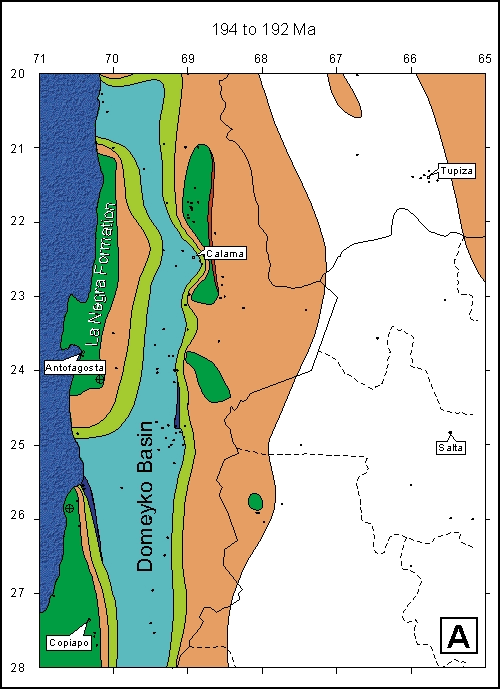