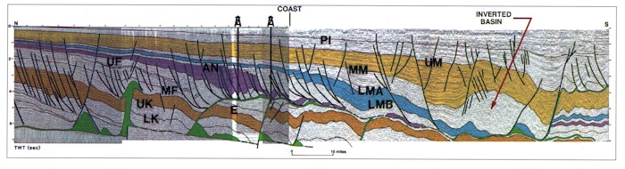
Figure 17-Interpreted seismic profile across the Oligocene-Miocene detachment province and mid-shelf salt dome-minibasin province. Strata above the salt detachment (green) form a series of expanded wedges that thin basinward above more isopachous subdetachment Eocene and older strata, which are deformed by counter-regional faults. Well symbols indicate wells that penetrate salt at the level of detachment. Pl = lower Pleistocene, UM = upper Miocene, MM = middle Miocene, LMA and LMB = lower Miocene, UF = Oligocene upper Frio, MF = Oligocene middle Frio, E = Eocene, UK = Upper Cretaceous, and LK = Lower Cretaceous. See Figure 2 for location. This vertically exaggerated profile is shown at true scale in Figure 35.