EVOLUTION OF THE ARCTIC-NORTH ATLANTIC AND THE WESTERN TETHYS--A VISUAL PRESENTATION OF A SERIES OF PALEOGEOGRAPHIC-PALEOTECTONIC MAPS*,
Peter A. Ziegler
Search and Discovery Article #30002 (1999)
*Maps and text (Introduction and Chapter 10) from AAPG Memoir 43, Evolution of the Arctic-North Atlantic and the Western Tethys, by Peter A. Ziegler. Adapted here for online presentation; included are the maps in time-lapse sequence, which require downloading for economy of online time. For references, please refer to Memoir 43, p. 164-196.
INTRODUCTION
Memoir 43 broadly outlines the Late Silurian to Recent evolution of the Arctic-North Atlantic and Western Tethys domains and their borderlands.
The Arctic-North Atlantic domain is considered in Memoir 43 as including part of the oceanic Canada and Eurasian basins, the Norwegian-Greenland Sea, the North Atlantic, the Labrador Sea, and Baffin Bay. The Western Tethys realm embraces the Mediterranean Sea, its Alpine fold belts, and the adjacent cratonic areas. Thus, the area covered by this compilation includes much of northeastern North America and Greenland, all of Europe, and the northern parts of North Africa.
Intensified studies of the classical outcrop areas have led to the development of new stratigraphical and structural concepts, particularly with regard to the evolution of the Caledonian, Hercynian, and Alpine fold belts. This has been paralleled by major efforts in the hitherto little known Arctic frontier areas.
The ever-increasing number of radiometric age determinations has contributed much to the dating of orogenic events and the intraplate igneous activity that accompanied the Paleozoic assembly of Pangea, its Mesozoic and Cenozoic break-up, and the Alpine suturing of Africa and Europe. In addition, faunal analyses and particularly paleomagnetic data have provided new constraints for the paleogeographic reconstruction of the Arctic-North Atlantic and Tethys domains. Regional marine geophysical surveys, supported by deep-sea drilling, have increased our knowledge of the geology and evolution of oceanic basins to the point that the inventory of sea-floor magnetic anomalies has provided a tool for the Mesozoic and Cenozoic palinspastic reconstructions of the Arctic-North Atlantic borderlands. This has greatly enhanced the understanding of the kinematics underlying the Jurassic to Recent evolution of the Mediterranean and Arctic-North Atlantic areas. Moreover, deep reflection surveys and refraction data have contributed substantially to the understanding of processes governing the evolution and destruction of sedimentary basins.
In recent years, the petroleum industry in its quest for new hydrocarbon resources has extended its exploration efforts to the limits of the perennially ice-infested Arctic frontier areas. Apart from establishing substantial new oil and gas reserves, these efforts have yielded a tremendous amount of new stratigraphical and geophysical information from hitherto inaccessible areas, depths and basins that one or two decades ago were hardly known to exist.
This wealth of new data, in combination with the geology of outcrop areas and the oceans, permits us to reconstruct the geological evolution of the Arctic-North Atlantic and Tethys domains in a modern, plate tectonic framework. Yet many questions must be left unanswered and that much remains to be learned from future research and exploration efforts and particularly from the pooling of knowledge. Moreover, the integration of an almost forbiddingly voluminous, multilingual literature demanded such a taxing effort that exhaustive coverage of the areas of interest could never be achieved.
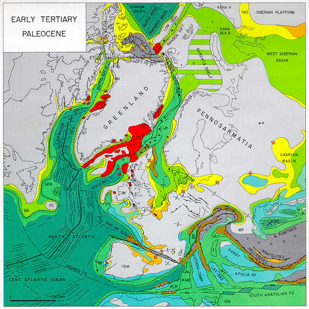
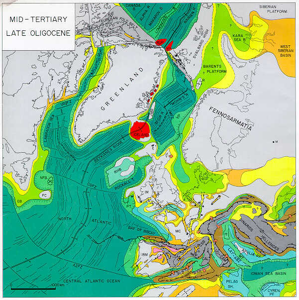
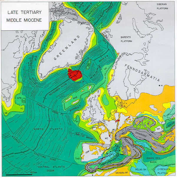
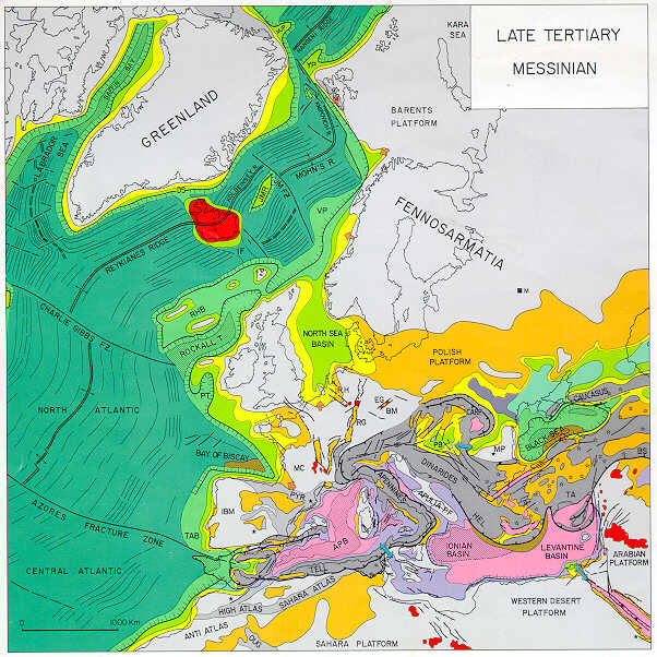
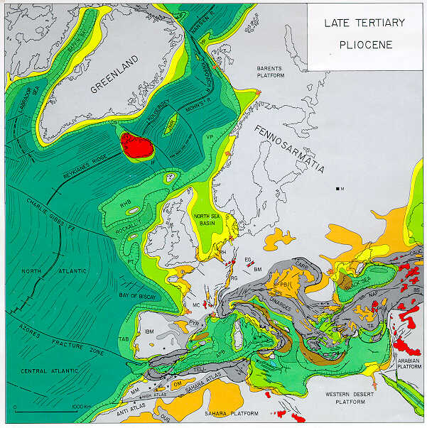
The account of the late Paleozoic to Recent evolution of the Arctic-North Atlantic and Western Tethys domains given in this volume centers on the discussion of 21 paleogeographic-paleotectonic maps (Plates 1-21). These are supported in Memoir 43 by chronostratigraphic-lithostratigraphic correlation charts, numerous cross sections, and detail maps given as text figures.
The individual paleotectonic-paleogeographic maps span large time intervals, and, in view of their scope, they are of an interpretative and in part even a conceptual nature. These maps give for the respective time interval maximum depositional basin outlines, gross lithofacies/depositional environment provinces in color code, and the principal tectonic features. For areas of nondeposition, a distinction was made between cratonic highs, tectonically active orogenic belts, and tectonically inactive fold belts characterized by a considerable topographic relief. Volcanic activity during the respective time interval is indicated by star symbols that distinguish between intraplate volcanism (black stars) and subduction-related volcanism (open stars). In view of the scope of these maps, depositional thickness values or isopachs could not be given; the reader is therefore referred to the literature quoted in the text.
The information given on the paleogeographic-paleotectonic maps was abstracted from more detailed maps that had been compiled for individual basins and provinces on the basis of in-house studies and/or published literature.
The topographic bases of these maps, showing the present-day continental outlines for areas not affected by orogenic activity during the respective time interval, are based on computer-generated palinspastic reconstructions of the Arctic-North Atlantic and the Central Atlantic Oceans as dictated by their sea-floor magnetic anomalies. These reconstructions were carried out at Shell Development Company's Bellaire Research Center in Houston using programs for computer animation of continental drift (Scotese et al., 1980). Devonian to Early Jurassic maps are essentially based on the predrift fit of the continents whereby paleomagnetic constraints were honored (Ziegler et al., 1979; Scotese et al., 1979, 1985; Morel and Irving, 1978). Empirical palinspastic corrections were applied to areas of important intracratonic deformation.
Projections are orthographic with the map center located in the northern part of Scotland. Because in many parts of the Central and North Atlantic, the Norwegian-Greenland and Labrador Sea, and Baffin Bay there is considerable uncertainty about the position of the continent-ocean boundary and the amount of crustal extension that occurred during the rifting phase preceding the opening of the respective ocean basins, the palinspastic reconstruction given in these maps should be regarded as tentative.
Furthermore, palinspastic reconstructions of the Alpine-Mediterranean domain are based on the assumption that during the Late Carboniferous and Permian the area between the African and European cratons was occupied by the Hercynian fold belt and thus, by continental crust. In the eastern Mediterranean-Black Sea area, the Hercynian fold belt probably faced the oceanic Proto- or Paleo-Tethys, which separated it from the northern, passive margin of Gondwana.
The area occupied by continental crust at the end of the Hercynian orogeny in the Western and Central Mediterranean domain was defined on the basis of the late Paleozoic-early Mesozoic trans-Atlantic fit of Laurentia, Africa, and Fennosarmatia. In the eastern Mediterranean-Black Sea area, the limits of the Proto-Tethys Ocean during the latest Carboniferous, and consequently the outlines of the Hercynian fold belt as shown in the Permo-Carboniferous reconstruction given by Plate 6, are conceptual.
As a next step, areas corresponding to the Alpine-Mediterranean domain were subdivided into tectonostratigraphic units such that certain interpretations and assumptions had to be made regarding the correlation and original size of the different units recognized in the Alpine chains. Although the size and shape of the individual tectonostratigraphic units, such as the Italo-Dinarid promontory, had to remain tentative, their distinction and the retention of their dimensions formed the basis for the conceptual Late Permian, Mesozoic, and Cenozoic palinspastic reconstructions given in Plates 7-21. This approach was chosen for the simple reason that reliable palinspastic reconstructions are not yet available for the different segments of the Alpine fold belts in the Mediterranean area. Correspondingly, space allocation to the different tectonostratigraphic units has been arbitrary and is subject to perhaps major changes as new information becomes available. Furthermore, as the inventory of magnetic sea-floor anomalies increases, motions of the major cratonic blocks during the opening phases of the different segments of the Arctic-North Atlantic can be more closely constrained and a better understanding will be obtained of the width of oceanic basins that opened during the Mesozoic in the Mediterranean domain.
It should therefore be stressed that the paleotectonic-paleogeographic maps presented in Plates 1 to 21 are generalized and that they may have serious shortcomings. Yet they provide a first overview of the post-Caledonian evolution of the entire Arctic-North Atlantic and Western Tethys areas and their borderlands. As such, they are intended to give the reader a broad framework on which to build and against which more local studies can be tested.
The chronostratigraphic-lithostratigraphic correlation charts in Memoir 43 summarize the sedimentary record of selected basins and subbasins that developed through time in the Arctic-North Atlantic borderlands and in Western and Central Europe. Each chart provides the reader with an overview of the geological record of geographically and (generally) also genetically related basins, with color-coded depositional environments, erosional and nondepositional breaks, summary of the tectonic and igneous activity that accompanied the evolution of the respective basins and, where applicable, also their destruction, and the angularity of unconformities, whether they are rift or wrench induced or associated with folding.
The text of Memoir 43 is organized, from the point of view of plate interaction, into a chronological account of the latest Silurian to Recent evolution of the Arctic-North Atlantic and Western Tethys realms. Also there is a discussion of geodynamic processes (included here as a modest revision of Chapter 10) that governed the subsidence and destruction of sedimentary basins which evolved during the long and complex geological history of the area under consideration. A summary of this discussion follows.
THOUGHTS AND SPECULATIONS ON GEODYNAMIC
PROCESSES
(Modest revision of Chapter 10, Memoir 43)
INTRODUCTION
The structural and stratigraphic record of the Arctic-North Atlantic borderlands and the Tethys domain reflects their complex geological evolution during which orogenic events, associated with the accretion of continental fragments and the collision of major continents, alternated with periods of wrench faulting and crustal extension. The latter resulted in the destruction of pre-existing fold belts and culminated ultimately in the break-up of the newly formed continent assemblies, to a large extent along their Paleozoic megasuture zones. Yet, it should be noted that some of the Pangea break-up axes are quite discordant with the Paleozoic megasutures (e.g., North Atlantic) and cut even across the Precambrian basement grain (e.g., Labrador Sea-Baffin Bay).
The geological evolution of the different parts of the Arctic-North Atlantic and Tethys domains reflects, through time, repeated changes in their megatectonic setting and, correspondingly, changes in the geodynamic processes that governed the subsidence and/or destruction of sedimentary basins. Thus, in time and space, basins of different geotectonic origin developed. Some of these were stacked on top of one another while others were partly destroyed during subsequent tectonic events.
These changes can be related to an almost unbroken sequence of tectonic processes that preceded and accompanied the reorganization of plate boundaries during the late Paleozoic to Recent evolution of the Arctic-North Atlantic and Tethys realms. The main steps of these reorganizations are recapitulated here.
MAIN PHASES OF PLATE REORGANIZATION IN ARCTIC-NORTH ATLANTIC AND TETHYS
The late Paleozoic progressive suturing of Pangea and its Mesozoic and Cenozoic disintegration, which was partly interrupted and even reversed by the Alpine collision of Africa with Europe, was accompanied by repeated changes in plate boundaries and changes in plate motions relative to each other. During the suturing phases of Pangea and also during the Alpine orogenic cycle, major oceanic basins became closed and important fold belts developed. The Mesozoic and Cenozoic break-up of Pangea, on the other hand, was associated with the opening of new oceanic basins, some of which are today no longer characterized by active spreading ridges.
The main phases of plate boundary reorganization that accompanied the late Paleozoic assembly of Pangea and its subsequent disintegration are summarized below.
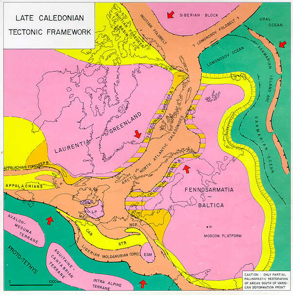
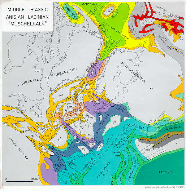
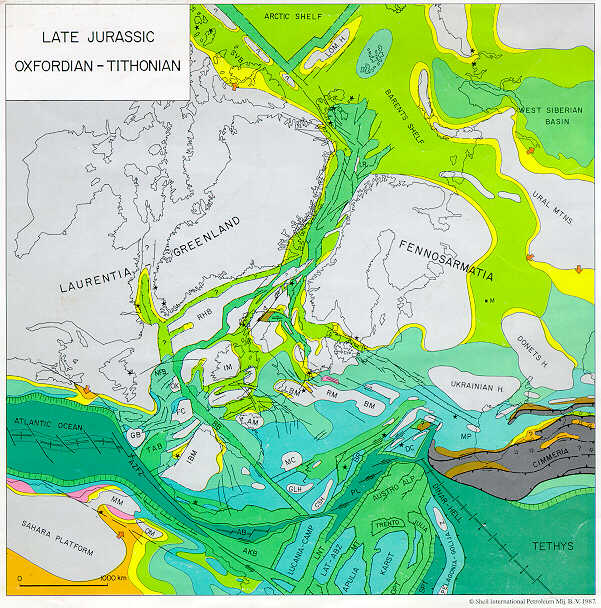
Caledonian and Pre-Hercynian Cycles (Ordovician-Devonian) (Plate 1, Plate 2, Plate 3)
The Caledonian orogenic cycle, spanning Late Cambrian to Silurian time, involved the collision of Laurentia-Greenland and Fennosarmatia and their suturing along the Arctic-North Atlantic Caledonides. This was accompanied by the northward subduction of the Proto-Tethys Ocean along an arc-trench system paralleling the southern margin of the newly forming Laurussian megacontinent to which a number of Gondwana-derived continental terranes became accreted. These terranes were rifted off the northern margin of Gondwana during the Ordovician and Early Silurian. Moreover, during the Caledonian orogenic cycle, the Arctic Craton converged and collided with the northern margin of Laurentia-Greenland.
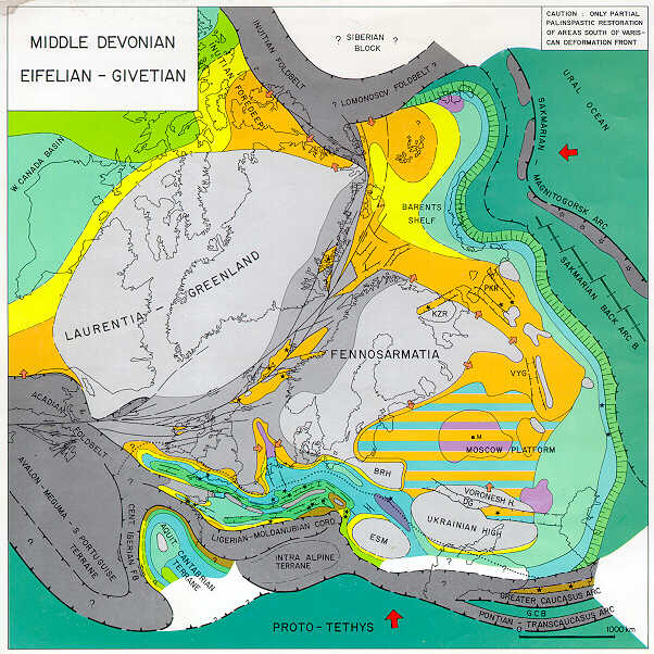
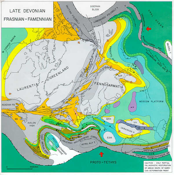
The Late Silurian-Early Devonian, late- to post-Caledonian plate reorganization is reflected by the abandonment of the Arctic-North Atlantic Caledonide subduction system, the inception of the intraoceanic Sakmarian arc-trench system to the east of Fennosarmatia-Baltica, and the development of a sinistral megashear system transecting the Arctic-North Atlantic Caledonides along their axis. During the Devonian and earliest Carboniferous, continued northward subduction of the Proto-Tethys plate, possibly at variable rates, was associated with intermittent back-arc extension in the domain of the Variscan geosynclinal system and the accretion of additional Gondwana-derived microcontinents (terranes) to the southern margin of Laurussia during the Middle Devonian Acado-Ligerian diastrophism. The latest Devonian-earliest Carboniferous suturing of Laurussia and the Arctic Craton along the Innuitian-Lomonosov fold belt was accompanied by major sinistral translations between Laurentia-Greenland and Fennosarmatia-Baltica. In the domain of the oceanic Sakmarian back-arc basin, a phase of back-arc compression, at the transition from the Early to the Middle Devonian, was followed by back-arc extension during the Givetian and the resumption of back-arc compression during the earliest Carboniferous.
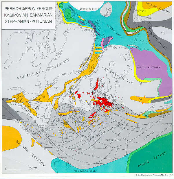
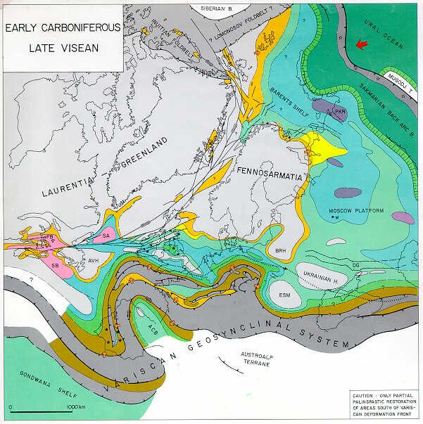
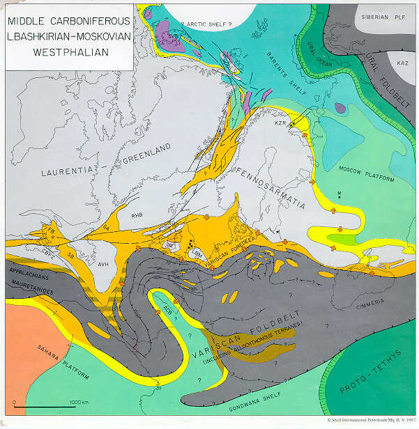
Hercynian Megacycle (Carboniferous-Early Permian) (Plate 4, Plate 5, Plate 6, Plate 7)
The Early Carboniferous collision of Gondwana with Laurussia marked the onset of the Hercynian orogenic cycle and the ensuing reorganization of plate boundaries. In Western and Central Europe, this is expressed by the compressional overpowering of the longstanding Variscan geosynclinal back-arc extension systems and the late Westphalian consolidation of the Variscan fold belt. The Early Permian consolidation of the Appalachian-Mauretanide fold belt during the Alleghenian diastrophism was associated with a change in the convergence direction between Gondwana and Laurussia. This gave rise to latest Carboniferous-Early Permian development of a dextral shear system transecting the newly consolidated Variscan fold belt; this shear system represented a diffuse plate boundary between Africa and Fennosarmatia.
In the Arctic domain, the Hercynian plate reorganization is expressed by back-arc rifting in the area of the Innuitian fold belt, inducing the Carboniferous subsidence of the Sverdrup Basin, possibly by the separation of the West Siberian Craton from Laurussia, and by the development of the Norwegian-Greenland Sea rift system.
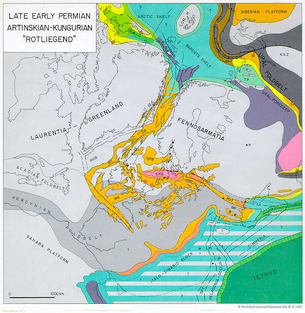
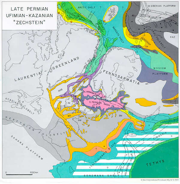
During the Carboniferous, the West Siberian Craton rotated away from the northern margin of Laurussia and began to converge with the Kazakhstan Craton and the eastern margin of Fennosarmatia. This marked the onset of the Uralian orogenic cycle that culminated during the Late Permian-Early Triassic in the consolidation of the Ural-Novaya Zemlya-Taimir and the Altay-Sayan fold belts. Back-arc extension, causing subsidence of the West Siberian Basin, commenced during the Late Permian and persisted into Late Triassic-Early Jurassic times.
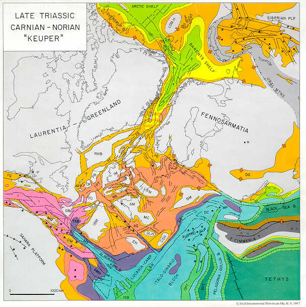
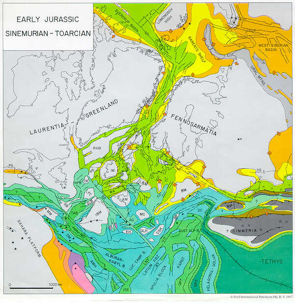
Post-Hercynian Plate Reorganization (Late Permian-Mid-Jurassic) (Plate 8, Plate 9, Plate 10, Plate 11, Plate 12)
The Uralian diastrophism was paralleled by the first phases of the post-Hercynian plate reorganization in the Tethys and Arctic-North Atlantic domains. This is evident from the Late Permian and Triassic southward propagation of the Norwegian-Greenland Sea rift system into the North and Central Atlantic area and the gradual westward propagatioo of the Tethys rift system. Particularly during the Triassic and Early Jurassic, large areas around future plate boundaries in the Tethys and Central and North Atlantic area were affected by tensional stresses.
Furthermore, Late Permian-Early Triassic back-arc extension, related to the decay of the Variscan subduction system, is thought to underlie the separation of the Cimmerian terrane sensu stricto (Balkan-northern Turkey) from the southern margin of Fennosarmatia and the opening of the oceanic Black Sea Basin. Mid-Triassic separation of the continental Central and East Iranian terrane from Arabia, on the other hand, was accompanied by the development of the Tethys sea-floor spreading axis. With this, the northward subductions of the remnant Paleo-Tethys Ocean, at an arc-trench system paralleling its northern margin, was initiated. This gave rise to the Cimmerian orogenic cycle spanning Mid-Triassic to Mid-Jurassic times during which the Central and East Iranian and the Cimmerian terranes were accreted to the southern margin of Eurasia.
Triassic and Early Jurassic gradual westward propagation of the Tethys sea-floor spreading axis and accelerated crustal distension in the Central Atlantic culminated during the Middle Jurassic in crustal separation between Gondwana and Laurussia along the axis of their Hercynian sutures.
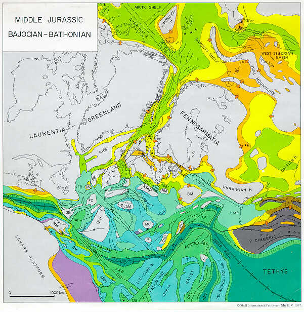
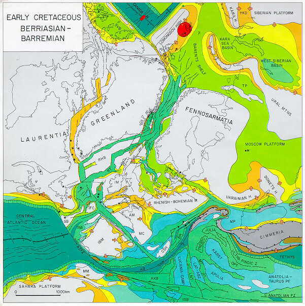
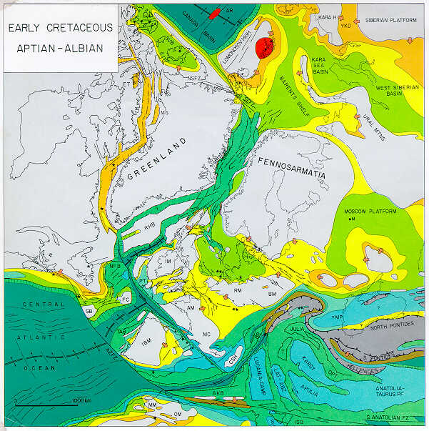
Late Mesozoic Break-up Phase (Mid-Jurassic-Early Cretaceous) (Plate 12, Plate 13, Plate 14, Plate 15)
Mid-Jurassic development of a discrete plate boundary between Africa-South America and Laurussia marked the onset of the late Mesozoic plate reorganization of the Atlantic-Tethys domain during which the new Central Atlantic sea-floor spreading system played a preeminent role. Late Jurassic-Early Cretaceous rapid opening of the Central Atlantic induced a sinistral translation between Fennosarmatia and Africa-Arabia whereby the western parts of the Tethys sea-floor spreading system became overpowered and decayed. Ensuing transtensional opening of oceanic basins in the Western and Central Mediterranean domains were followed by the earliest Cretaceous collision of the ltalo-Dinarid promontory with the southern margin of Fennosarmatia. This gave rise to the early Alpine orogenic phases. Continued sinistral translation between Africa and Fennosarmatia was accompanied by the partial decoupling of the Italo-Dinarid Block from Africa, its counterclockwise rotation, and the westward and eastward propagation of the early Alpine collision front.
Following crustal separation in the Tethys area, evolution of the Northwest European graben systems was exclusively governed by tensional stress systems related to the Arctic-North Atlantic megarift. During the Early Cretaceous, the Central Atlantic sea-floor spreading axis propagated into the North Atlantic domain and during the Late Cretaceous into the Labrador Sea. This was associated wth northward rift propagation into the Baffin Bay and the southeastern parts of the Canadian Arctic Archipelago.
Late Jurassic rifting along the northern margin of the latter culminated during the Valanginian in crustal separation, the counterclockwise rotation of the Alaska-Chukotka-Chukchi and New Siberian Island blocks away from Laurussia, and the opening of the oceanic Canada Basin. This fundamental plate reorganization in the Arctic eventually paved the way for crustal separation between Laurentia-Greenland and Fennosarmatia. Sea-floor spreading in the Canada Basin terminated at about the same time that sea-floor spreading was initiated in the Labrador Sea.
Aptian crustal separation between Africa and South America and linking up of the Central Atlantic and the southern South Atlantic sea-floor spreading axes was followed during the Late Cretaceous by sea-floor spreading in the South Atlantic-Indian Ocean. The resulting counterclockwise rotation and northward drift of Africa-Arabia underlies the Alpine plate reorganization of the Tethys domain during which collisional plate boundaries propagated rapidly into the Western and Eastern Mediterranean areas.
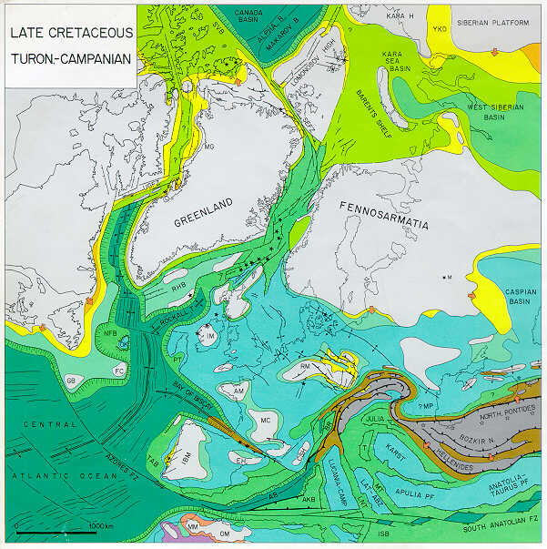
Alpine Megacycle (Late Cretaceous-Cenozoic) (Plate 16, Plate 17, Plate 18, Plate 19, Plate 20, Plate 21)
During the early Alpine orogenic cycle, spanning Late Cretaceous and Paleogene times, progressive closure of young oceanic domains in the Western and Central Mediterranean area was followed by the collision of Africa and Europe. This was accompanied by important intraplate compressional deformations in Europe and in North Africa.
The Main Alpine orogeny paralleled the second Arctic plate boundary reorganization. During the latest Paleocene-earliest Eocene, the North Atlantic sea-floor spreading axis propagated northward into the Baffin Bay, the Norwegian-Greenland Sea, and the Eurasian Basin. During the early phase of sea-floor spreading north of the Charlie Gibbs fracture zone, rotation of North America, Greenland, and Eurasia relative to each other induced the compressional deformation of the Eastern Sverdrup Basin and of the western margin of the Barents Shelf. The resulting Eurekan and Spitsbergen orogens are of a passive collisional nature and are not associated with long-standing subduction zones.
Following the early Oligocene abandonment of the Labrador-Baffin Bay sea-floor spreading axis, and the late Oligocene stabilization of spreading axes in the Norwegian-Greenland Sea, crustal separation was achieved between Northeast Greenland and the Barents Shelf. With this, present-day plate boundaries were established in the Arctic-North Atlantic.
The late Paleogene and Neogene Main and late Alpine plate reorganization of the Tethys domain can be related to dextral translations between Europe and Africa in response to differentials in sea-floor spreading rates in the Central Atlantic and the Arctic-North Atlantic. This plate reorganization was accompanied by the Miocene and Pliocene development of important intramontane wrench systems, the subsidence of the Aegean and Pannonian basins, the opening of the oceanic Algero-Provencal Basin, and later the subsidence of the Tyrrhenian back-arc basin. This was accompanied by the gradual concentration of crustal shortening to the Western Alps, the Apenninen-Calabrian Arc, the southern Carpathian, and the Hellenic-Taurid Arc.
During the Oligocene and Neogene, the Indian Ocean sea-floor spreading axis propagated under the Afro-Arabian Craton, causing the opening of the Red Sea Rift and possibly the subsidence of the North Lybian-Pelagian Shelf rifts. This was paralleled by the evolution of the Rhine-Rhone graben system that extends southwestwards through the western Mediterranean and crosses the Rif fold belt. Development of these rift systems can be construed as heralding a post-Alpine plate reorganization that may ultimately lead to the disintegration of the present continent assembly.
This summary illustrates that the Late Silurian to Recent evolution of the Arctic-North Atlantic and Tethys domains was governed by a sequence of plate reorganizations during which a broad spectrum of geodynamic processes was responsible for the development and subsequent partial to total destruction of sedimentary basins.During the last decade, a number of geophysical models have been advanced in an attempt to explain the development of sedimentary basins under different geodynamic settings. Moreover, the dynamics and evolution of asthenospheric convective systems have been the focus of important research.In the following chapters, implications drawn from the evolution of sedimentary basins in the Arctic-North Atlantic and Tethys domains are compared with currently favored models of basin evolution, and some speculations are advanced as food for thought.
RIFTING PROCESSES
Rifts and rift-related passive margin basins play a preeminent role among the sedimentary basins that have developed through time in the Arctic-North Atlantic and Tethys domains. During the late Paleozoic to Cenozoic time span, several cycles of rifting are recognized whereby the subsidence of graben-shaped basins took place under different megatectonic settings.
In this respect, a distinction is made between rifting that led to the break-up of cratonic areas and the opening of major Atlantic-type oceans and back-arc rifting that is related either to decreased convergence rates of a continental and an oceanic plate (Uyeda, 1982) or to the decay of a subduction system following the consolidation of an intracontinental suture (e.g. West Siberian Basin).
The development of pull-apart features associated with major wrench faulting (e.g., Oslo Graben) represents a special category of often rapidly subsiding grabens. Development of such pull-apart basins can be associated with Atlantic-type and also back-arc rifting (e.g., late Paleozoic and Mesozoic basins of Svalbard and northern Ellesmere Island, and Neogene Aegean and Pannonian basins).
Intracratonic Rifts
Numerous models have been proposed for the development of intracratonic rifts and passive margins. These models can be subdivided into two groups. The first group deals principally with the mechanical behavior and deformation patterns at upper and lower crustal and subcrustal lithospheric levels, whereby the emphasis is on mechanical stretching of the lithosphere. The second group addresses the thermally induced upward displacement of the asthenosphere-lithosphere boundary in response to upwelling asthenospheric currents.
One of the earliest rifting models is the uniform stretching or pure shear model (McKenzie, 1978), which assumes that the crust and subcrustal lithosphere are attenuated by an equal amount of stretching whereby deformations are confined to the actual rift zone (Figs. 73, 74). This model has later been modified to the so-called nonuniform or discontinuous depth-dependent stretching model (Royden and Keen, 1980; Beaumont et al., 1982a, 1872b; Hellinger and Sclater, 1983) in which the amount of stretching at crustal and subcrustal lithospheric levels is not the same. This model, which requires an intralithospheric discontinuity (base of the crust), entails space problems at subcrustal lithospheric levels and is therefore not satisfactory. A further modification to the discontinuous nonuniform stretching model has recently been proposed by Rowley and Sahagian (1986) whose continuous (uniform), depth-dependent stretching concept assumes an equal amount of extension at upper and lower lithospheric levels whereby extensional strain is diffused at deeper levels over a wider area than at shallower levels. Both depth-dependent stretching models attempt to account for the broad symmetrical shoulder uplift that is often associated with active rifts (Salveson, 1981; Mareschal, 1983; Turcotte and Emerman, 1983).
On the other hand, the simple shear model (Wernicke, 1981, 1985; Davis et al., 1986; Ussami et al., 1986) invokes, during periods of lithospheric extension, the development of an intracrustal shear zone along which upper crustal distension by faulting is taken up along a discrete shear zone that dips laterally into lower crustal and possibly through upper mantle levels. In this model, zones of upper and lower crustal and subcrustal lithospheric attenuation do not necessarily coincide as in the pure shear model. The simple shear model satisfies many of the geometric relationships evident on reflection seismic data at upper and middle crustal levels and may explain the absence of post-rifting subsidence of marginal grabens, which are apparently underlain by nonattenuated lower crust (see, e.g., Ussami et al., 1986). Yet the transfer of tensional strain at subcrustal lithospheric levels to one side of the respective rift system would entail an asymmetric uplift of rift shoulders (Wernicke, 1981, 1985; Wernicke and Burchfiel, 1982; Coward, 1986). In extreme cases of the simple shear model, the zone of lower crustal and subcrustal lithospheric attenuation could lie entirely outside the zone of upper crustal stretching. During the rifting stage, this area of nonattenuated upper crust would become progressively uplifted and, during the postrifting stage, develop into a thermal sag basin. This concept has led to the development of the "linked tectonics" model (Beach, 1985).
This concept is, however, difficult to reconcile with the geological record and the heat flow patterns of many rifts (e.g., Rhine Graben, Red Sea).
Barbier et al. (1986) have modified the simple shear model by assuming that the intracrustal shear zone, into which faulting at upper crustal levels soles out, coincides with the transition zone of brittle and ductile deformation. This model suggests, similar to the continuous depth-dependent stretching concept, that tensional strain is dissipated at lower crustal and subcrustal lithospheric levels by ductile flow over a wide zone extending beyond both margins of the upper crustal rift. This would account for a more or less symmetrical doming of rift flanks. Permutations to this combined simple and pure shear model are discussed by Kusznir et al. (1987).
The validity of the different rift models needs to be tested against examples of rift zones for which full geophysical data sets are available, including gravity, shallow and deep reflection, and refraction seismic surveys. These data ought to be of sufficient quality and extent to determine the depth converted crustal configuration of the respective rift zone, the attenuation (stretching) factors at upper and lower crustal levels, the reflectivity of the upper and lower crust as well as the definition of potential intracrustal detachment and/or shear zones. Moreover, such "case history" analyses must also take into consideration heat flow data and the distribution and chemical composition of rift-related igneous activity.
Partial data sets, available for a number of rift zones (e.g., North Sea, Rhine Graben) and also for passive margins (e.g., Bay of Biscay, East Newfoundland Basin), indicate that the stretching factor determined for lower crustal attenuation by refraction data exceeds the ß-factor at upper crust at levels as derived from reflection seismic data. The observed discrepancy is generally in the order of 3:1. Although the reliability of stretching factors derived from reflection seismic data for shallow crustal levels has been repeatedly challenged (Wood and Barton, 1983; Barton and Wood, 1984; see also Sclater et al., 1986) the magnitude of these observed discrepancies is too large to be simply attributable to "margins of error" or "linked tectonics" (Beach, 1985) as advocated by the original simple shear model.
This suggests that during rifting phases, attenuation of the lower crust may be achieved not only by its mechanical stretching but also by other mechanisms; moreover, the question raised whether during advanced rifting stages lower crustal material conservation and stability of the Moho Discontinuity are still valid concepts (Meissner, 1986).
The driving mechanism of lithospheric extension has been variably attributed to plate boundary forces acting at trenches, particularly when subduction takes place at opposite sides of large continental masses, to mantle plume activity and to the projection and/or gradual development of upwelling asthenospheric convective systems under continents (Bott, 1982; Turcotte, 1981; Turcotte and Emerman, 1983; Neugebauer, 1983).
The Mesozoic and Cenozoic break-up of Pangea, as evident by the evolution of the Arctic-Central Atlantic and Tethys rift systems, suggests that the latter processes are probably the dominant driving force of large-scale lithospheric extension. The Triassic-Early Jurassic rift systems of the North Atlantic and Tethys domains and of West-Central Europe cover an area of 2000 km by 3500 km. Most of these grabens were a-volcanic and crustal doming played only a subordinate role. This speaks against the development of these rifts in response to the emplacement of a multitude of hotspots. Furthermore, it is questionable whether subduction processes along the distant margins of Pangea played a major role in the development of the Triassic Gondwana rifts and those of the Arctic-North Atlantic and Tethys domains.On the other hand, the Mid-Triassic separation of the Central and East Iranian terrane from Arabia testifies to the evolution of the Tethys sea-floor spreading axis. Jurassic westward propagation of this axis, in conjunction with the development of the West Mediterranean-Central Atlantic-Gulf of Mexico ridge-transform system, resulted in crustal separation between Gondwana and Laurasia.
This sequence of events suggests that the multidirectional graben systems of the North and Central Atlantic, Tethys, and West-Central European areas developed probably in response to frictional forces exerted on the lithosphere by gradually developing upwelling convective systems beneath the central parts of Pangea. These systems asserted themselves during the Mid-Jurassic by the development of the Tethys-Central Atlantic sea-floor spreading systems and during the Cretaceous and Paleogene by the development of the North Atlantic and Norwegian-Greenland sea-floor spreading axes.
Upwelling asthenospheric currents are thought to cause thinning of the lithosphere by inducing a thermal upward displacement of its lower boundary whereby they probably exert tensional stresses on it. In time, this can lead to lithospheric failure, crustal separation, and the opening of new oceanic basins (Richter and McKenzie, 1978; Chase, 1979; McKenzie et al., 1980). The regional lithospheric extension that precedes continental splitting can affect wide areas around the future plate boundaries. This is exemplified by the Triassic Tethys, Central, and North Atlantic rift systems. With the progression of crustal extension, rifting activity frequently concentrates to the axial rift zones whereby peripheral grabens and fault systems become inactive (e.g., rift systems of Western Europe and Barents Sea relative to Norwegian-Greenland Sea Rift).
In such a tectonic setting, the duration of the rifting stage of "abortive" rifts, in which crustal separation is not achieved, and of "successful" rifts, culminating in crustal separation, is highly variable. This is illustrated by the diagrams given in Figures 75 and 76. For instance, opening of the Central Atlantic Ocean was preceded by a rifting stage spanning some 50 Ma while intermittent rifting lasted in the Norwegian-Greenland Sea for some 275 Ma.
The observed variations in the duration of the rifting stage of successful rifts is probably a function of the time required for the evolution of upwelling asthenospheric convective systems to a point where they are able to drive apart major continents. Prior to crustal separation, these convective systems are probably partially decoupled from the overlying lithosphere, with full coupling being established during or immediately after crustal separation. This concept cannot, however, be generalized as suggested by the abandonment of early sea-floor spreading axes in favor of new ones. This is exemplified by the Oligocene abandonment of the Labrador-Baffin Bay and the Aegir spreading axes in favor of the Reykjanes-Kolbeinsey-Mohn's spreading axis. Furthermore, minor oceanic basins, such as those of the southern Rockall Trough and the Bay of Biscay, are characterized by only a short period of sea-floor spreading after which they cease to open further. Such basins are probably not directly associated with major asthenospheric upwelling systems, and their oceanic crust may have formed by passive asthenospheric advection into a lead opening in response to regional stress patterns. Similar mechanisms may have played a role during the opening of the Labrador Sea-Baffin Bay and northern North Atlantic-Norwegian-Greenland Sea. The early phases of sea-floor spreading in the Labrador Sea were paralleled by continued crustal extension in the northern North Atlantic and the Norwegian-Greenland Sea. Ultimate abandonment of the Labrador Sea-Baffin Bay spreading axis, and late Oligocene stabilization of spreading axes in the Norwegian-Greenland Sea to the Kolbeinsey Ridge, also suggests that the Labrador Sea spreading system and the Aegir Ridge were not superimposed on a permanent, deep asthenospheric upwelling cell. In turn, this indicates that opening of the Labrador Sea was induced by the rotation of North America, driven by the Central and North Atlantic spreading system, and not so much by the active northward propagation of the latter.
The apparent nearly simultaneous abandonment and inception of distant sea-floor spreading systems may give an indication of the magnitude of the asthenospheric convection cells and their evolution, a subject that is not further analyzed here.
If tensional forces exerted on the lithosphere by gradually developing asthenospheric upwelling systems are indeed the main driving mechanism of lithospheric extension, it should be kept in mind that lithospheric attenuation can be achieved not only by its stretching but also, at the same time, by a thermal upward displacement of the asthenosphere-lithosphere boundary (Morgan and Baker, 1983; Fleitou et al., 1986). These processes are apparently associated with the decompression of the asthenosphere inducing partial melting at the base of the lithosphere and, on the other hand, with the advection of hot asthenospheric material to the base of the lithosphere (Spohn and Schubert, 1983; Neugebauer, 1983). Both processes can apparently trigger the diapiric ascent of alkaline, mafic-felsic bimodal magmas to shallower lithospheric levels, to the crust-mantle boundary and ultimately to the surface, whereby their composition reflects through time the gradual upward displacement of the asthenosphere-lithosphere boundary (see Wendlandt, 1981; Wendlandt and Morgan, 1982; Fuchs et al., 1983).
Thermal upward displacement of the asthenosphere-lithosphere boundary, probably involving small-scale convective processes even during the precrustal separation stage (Bott, 1976, 1981; Spohn and Schubert, 1983), combined with mechanical stretching of the lithosphere, can result in greater subcrustal lithospheric attenuation (ßm) than at crustal levels (ßc), to the end that ßm is greater than ßc (see nonuniform or depth-dependent stretching model, Royden and Keen, 1980; Beaumont et al., 1982b; Hellinger and Sclater, 1983; Steckler, 1985). Progressive, thermally induced, upward displacement of the asthenosphere-lithosphere boundary causes the gradual upwarp of broad rift domes that reach their maximum dimensions prior to or at the moment of crustal separation (mantle plume model; e.g., Red Sea, East African Rift, Early Jurassic Central Atlantic).
During the crustal separation stage, dike intrusions in the axial rift zones and convective lateral subcrustal lithospheric thinning (Fleitou and Yuen, 1984), accompanied by lower crustal flowage (Moretti and Pinet, 1987), are thought to play an important role. A further possible mechanism for lower crustal thinning may involve the injection of asthenospheric material into the lower crust leading to its gradual basification (subcrustal erosion). These processes are irreversible and may have contributed in many passive margin basins to substantially greater lower crustal attenuation than the upper crustal thinning by tensional faulting as evident on reflection seismic data (e.g., northern margin of Bay of Biscay; East Newfoundland Basin; West Norway basins; and also on the northwestern margin of the Provencal Basin (Le Douaran et al., 1984; Bessis and Burrus, 1986; Moretti and Pinet, 1987). This raises the question of whether during rifting the mass of the lower crust is actually being conserved or whether the geophysically defined Moho Discontinuity can be displaced upward by physicochemical processes (Olsen, 1983; Pinet et al., 1987).
Furthermore, at high rates of extension, even at an early stage of rifting, temporary, local failure of the lithosphere may trigger the diapiric rise of asthenospheric material to upper mantle levels and/or to the crust-mantle boundary, where it reaches a density equilibrium and spreads out laterally to form a so-called asthenolith, referred to also as a "rift pillow" (tensional failure model; Turcotte, 1981; Turcotte and Emerman, 1983). The emplacement of such low-density, low-velocity upper mantle anomalies as observed, for instance, beneath the southern Rhine Graben and the Massif Central (Perrier and Ruegg, 1973; Fuchs et al., 1981; Mechie et al., 1983) can cause the temporary uplift of a graben and with this a reversal of its subsidence pattern. This is exemplified by the Mid-Jurassic doming of the Central North Sea Graben area and the early Miocene upwarping of the Rhenish Shield. In both cases, earlier accumulated synrift deposits became deeply truncated during the doming stage, even in the axial rift zone.
Asthenoliths are thermally unstable upper mantle anomalies and are apparently resorbed into the upper mantle upon cooling, once the supply of hot asthenospheric material has ceased. This probably involves phase changes that may cause rapid subsidence of the overlying rift zone (Artyushkov, 1983) as evident, for instance, by the late Middle and Late Jurassic collapse of the Central North Sea rift dome. The evolution of the Loppa Ridge, flanking the Byornoya Graben of the Western Barents Sea, which underwent a first phase of uplifting at the transition from the Permian to the Triassic and a second one at the Jurassic-Cretaceous boundary, suggests that such intermittent doming can be recurrent.
During the development of an asthenolith, emplacement of hot asthenospheric material at the crust-mantle boundary probably induces, even in the face of limited crustal extension, additional lower crustal attenuation by subcrustal erosional processes, possibly involving the injection of mantle-derived material into the lower crust. These processes may be associated with the development of the reflection seismically defined lower crustal laminations. These high amplitude, intra-lower crustal reflections, as evident, for instance, in the southern Rhine Graben; Meissner, 1986; Meissner and Kusznir, 1986), in the northern North Sea, in the area of the Celtic Sea and Western Approaches troughs (Pinet et al., 1987), and in the rift-wrench-induced Paris Basin, indicate the presence of high density-velocity contrasts within the lower crust. Such lower crustal impedance contrasts may be associated with high density, mantle derived sills, metamorphic layering, or shear zones (Wever and Meissner, 1986; Moretti and Pinet, 1987). In general, these lower crustal laminations disappear away from the actual rift zones and are absent in areas of flanking, stable cratonic blocks; thus they appear to be, in a way, related to rifting processes. If these lower crustal laminations can, indeed, be related to the injection of mantle-derived material into the lower crust (Meissner, 1986; Bois et al., 1987), it would seem plausible that this process may ultimately lead to the basification of the lower crust and to an upward displacement of the geophysically defined crust-mantle boundary (subcrustal erosion), a process akin to the ones discussed by Beloussov (1960, 1962, 1975).
At the same time, heating up of the lower crust probably increases its ductility and induces a gradual upward displacement of the brittle/ductile deformation transition zone (Pinet et al., 1987). Correspondingly, simple shear deformations may play a dominant role during early rifting phases, and pure shear deformations may be the prevailing mechanism during advanced stages of crustal extension particularly when the asthenosphere has ascended to the base of the crust (see Barbier et al., 1986).
Many rifts are totally devoid of volcanic activity or show only a very low level of volcanism (e.g., Triassic rifts of Western and Central Europe). Such rifts are generally not associated with progressive, wide-radius doming. Other rifts, however, display a high level of volcanic activity right from the onset of crustal extension, such as the Rhine Graben, or become temporarily volcanic after an initial stage of nonvolcanic subsidence (e.g., North Sea Central Graben during the Middle Jurassic). Such volcanic activity is often associated with symmetrical doming of the rift zone.
Major variations in intensity and timing of volcanic activity are also evident during the rifting stage of passive margins. For instance, the early rifting stages of the Labrador Sea were accompanied by a high level of volcanic activity while the Mid-Norway Basin remained apparently nonvolcanic during its long rifting history until the latest Cretaceous-early Eocene Thulean volcanic surge preceded and accompanied crustal separation in the Norwegian-Greenland Sea.
Volcanism associated with intracratonic rifts is typically alkaline and felsic-bimodal (Martin and Piwinsky, 1972; Burke and Dewey, 1973; Lameyre et al., 1984). Initial volcanic activity is frequently alkaline felsic but changes with increasing lithospheric thinning to a tholeiitic basalt (Wendlandt, 1981; Wendlandt and Morgan, 1982). In wrench-related troughs initial magmatism is, however, often basaltic (e.g., Aquitaine Basin).
Triple junctions, where crustal and subcrustal lithospheric attenuation is most intense, are the likely places for an early manifestation of rift volcanism (e.g., northern Rhine Graben and North Sea Rift). However, while volcanic activity is not necessarily restricted to zones of upper crustal extension, the occurrence of lateral volcanic centers appears to be limited to the area of the corresponding rift dome and by implication to the zone of the thermally upward-displaced asthenosphere-lithosphere boundary. In the case of the Rhine Graben, lateral volcanic centers are confined to the outlines of the subcrustal asthenolith. Chemical differences between volcanics extruded within the actual rift zone and those extruded in peripheral areas are related to the differences in depth of magma generation (Wendlandt, 1981; Lameyre et al., 1984).
The extrusion of major volumes of plateau basalts, immediately preceding and accompanying crustal separation, is not characteristic for all passive margins. For instance, crustal separation between Iberia, the Grand Banks, and the southwestern margin of Europe and also between the Canadian Arctic Archipelago and the Chukotka-Chukchi block of Alaska were not accompanied by a volcanic surge of the dimensions of, for instance, the Thulean volcanism of the northern North Atlantic and the Norwegian-Greenland Sea. In this respect, it is suspected that, if the motion of incipient diverging plates is unrestrained, crustal separation can be effected relatively easily and thermally upwelling asthenospheric material will be accreted to the new plate boundaries as oceanic lithosphere. Conversely, if the divergence of continental blocks is impeded, the advecting mantle material will be injected into the crust and ultimately be extruded as flood basalts. Restraints in the separation of continents can be caused, on the one hand, by their partial coherence on trend of the respective rift zone (e.g., Jurassic-Early Cretaceous opening of the South Atlantic and Karoo basalts of South Africa and Sierra Geral basalts of Brazil), and, on the other hand, by collision-related tangential compressional stresses (e.g., Thulean volcanism of northern North Atlantic, Plate 17. Once these constraints in plate motion are removed, sea-floor spreading will commence and intracratonic volcanism will cease in the adjacent borderlands at the expense of accretion of new oceanic crust at the new spreading ridge.
Igneous activity in many highly volcanic rifts can culminate in the intrusion of felsic plutonic differentiates which, on trace element analyses, contain substantial amounts of reactivated crustal material.
This is exemplified by the Ordovician magmatism accompanying the separation of microcontinents from the northern margin of Gondwana (Priem and den Tex, 1984; Weber, 1984; Matte, 1986), the magmatic history of the Permian Oslo Rift (Neumann, 1985), and of the Permo-Triassic Dinarid rift system (Pamic, 1984). A further example is provided by the Early Tertiary Thulean volcanism (Thompson, 1982). This suggests that crustal contamination of rising mantle-derived magmas involving anatectic remobilization of the lower crust can play an important role during the evolution of a rift. This supports the concept that the crust-mantle boundary can become seriously destabilized during rifting processes and, by implication, casts doubt on the assumption that lower crustal attenuation can be translated, without reservations, into a stretching factor.
Clearly, the evolution of intracratonic rifts shows many variations, which cannot be explained by a few simplistic models. Much has yet to be learned from a multidisciplinary approach and the careful integration of geological and geophysical data. It is important that such studies are based on full data sets, including stratigraphic information from wells, results of shallow and deep reflection seismic surveys calibrated by refraction data, and gravity surveys. Moreover, it should be taken into account that the igneous record of a rift can provide important information on the depth of magma generation through time and space, on the gradual ascent of the asthenosphere-lithosphere boundary, and on the location of the asthenosphere-lithosphere boundary anomaly relative to the zone of upper crustal extension.
Back-Arc Extension
Several forms of back-arc extension are recognized, all of which differ to varying degrees in their megatectonic setting and possibly also their driving mechanisms.
The classical form of back-arc extension is the Pacific type, described by Uyeda (1982), which is associated with intraoceanic island arcs and also arc-trench systems marking the collision zone between an oceanic and a continental plate. In such a setting, back-arc extension is thought to be related to the development and assertion of secondary upwelling convection currents in the mantle wedge immediately above the subducting lithospheric slab. Tensional stresses exerted by such convective systems on the overriding plate are apparently capable of inducing back-arc rifting and sea-floor spreading only if the convergence rate between the subducting and the overriding plates is relatively low or if the plates diverge. This is presumably accompanied by partial decoupling of the two colliding plates at the Benioff zone which, under these conditions, is likely to display a relatively steep dip (Mariana-type). On the other hand, if convergence rates are relatively high, stronger coupling at the Benioff zone results in compressive deformation of the back-arc areas and the overpowering of back-arc convective systems. Under these conditions, the Benioff zone is likely to dip relatively gently under the overriding plate (Andean type) (Uyeda, 1981, 1982; Hsui and Toksoz, 1981; Zonenshain and Savostin, 1981). Moreover, the dip of a Benioff zone and the associated stress regime in back-arc areas appear to be related to the age of the subducting oceanic lithosphere whereby Benioff zones involving the subduction of old oceanic lithosphere generally display a steeper dip than those involving the subduction of young oceanic lithosphere (Jarrard, 1986). Nevertheless, as convergence rates and directions between plates are not constant and appear to change through time, periods of back-arc extension and back-arc compression can alternate with each other. Correspondingly, back-arc rifts and back-arc oceanic basins are prone to destruction, particularly under the impact of continent-to-continent collision.
The Devonian to Early Carboniferous Variscan geosynclinal system of back-arc basins can be considered as reflecting the evolution of an intracontinental Pacific-type back-arc system. Its destruction during the Variscan orogeny is related to the collision of Gondwana with Laurussia.
The Late Silurian to Early Carboniferous Sakmarian arc-trench and back-arc basin reflects the evolution of an intraoceanic, Pacific-type back-arc system in which periods of back-arc compression alternated with back-arc extension. This system was destroyed during the Uralian orogeny when the Kazakhstan and Siberian cratons converged and collided with the eastern margin of Fennosarmatia.
The Permo-Triassic phase of sea-floor spreading in the Black Sea was probably induced by back-arc extension, and as such is likely to reflect the decay of the Variscan subduction system. Late Triassic and Early Jurassic closure of this basin was induced by the convergence of Cimmeria with the southern margin of Fennosarmatia in response to increasing activity along the Tethys sea-floor spreading axis. The late Senonian to Paleocene second phase of back-arc sea-floor spreading in the Black Sea is probably related to the early Alpine reduced activity along, and the decay of, the Pontides subduction system since by that time the bulk of crustal shortening was taken up along the Hellenic-Anatolid subduction zone. A second type of back-arc extension is associated with the late-to-postorogenic collapse of fold belts forming the megasutures between major cratons. This is exemplified by the Permo-Triassic evolution of the West Siberian Basin, the Permo-Carboniferous evolution of the Sverdrup Basin, and the Neogene development of the Pannonian Basin. The subsidence of this type of back-arc basin may be induced by the decay of a long-standing subduction zone along which oceanic lithosphere and later continental lower crustal and upper mantle material were consumed whereby the Benioff zone dipped gently under the areas that subsequently were affected by extension. Gradual steepening of such a Benioff zone as a consequence of decreasing convergence rates of the colliding cratons and ultimately its locking may permit the development of secondary upwelling convection systems in the mantle wedge above the subducting lithosphere slab. Rapid extension of the overlying, immature, and thickened crust, which is partly permeated by synorogenic calc-alkaline plutons, is often associated with the extrusion of widespread basaltic to rhyolitic flows (e.g., West Siberian Basin, Plate 8, Plate 9, Plate 10).
The duration of such a phase of active back-arc extension is poorly constrained but apparently lasted in the case of the West Siberian and Sverdrup basins some 50 to 60 Ma. However, the time required for the decay of a fully locked subduction system, associated with a Himalayan-type orogen, may be shorter. In this context, it should be kept in mind that in the case of the West Siberian Basin, the early phases of back-arc extension coincided with the last phases of crustal shortening in the external Uralides.
In back-arc basins, the extension-induced thermal surge and initial phase of basin subsidence is followed by a period of lithospheric cooling and contraction causing regional basin subsidence. This is particularly well illustrated by the evolution of the West Siberian Basin (Artyushkov and Baer, 1986).
The Neogene Pannonian and Aegean back-arc basins, which developed during the late Alpine orogenic cycle, represent a modified form of this type of back-arc extension. Tensional subsidence of these basins was associated with major wrench deformations and important crustal shortening in the related arc-systems. These deformations are, to a large extent, the expression of changes in the convergence direction between the colliding continents and also of indenter effects and ensuing "escape tectonics."
In such basins, wrench-induced deep crustal fracturing, accompanying the development of pull-apart structures, can apparently trigger an intense, predominantly calc-alkaline initial volcanism. Alkaline bimodal suites play only a subordinate role, but in time may gain in importance. The thermal surge, associated at least with the early subsidence phases of such back-arc basins, may be coupled with an upward displacement of the crust mantle boundary by physicochemical processes (subcrustal erosion) as evident in the Pannonian Basin.
The latest Carboniferous-Early Permian evolution of the Variscan fold belt probably reflects a phase of wrench-dominated back-arc extension that was governed, on the one hand, by the decay of the Variscan subduction system, and on the other hand. by the dextral translation of Gondwana relative to Laurussia during the Alleghenian orogenic cycle (Lorenz and Nicholls, 1984; Jowett and Jarvis, 1984.
A further form of synorogenic back-arc extension is represented by the Neogene opening of the oceanic Algero-Provencal Basin and the subsidence of the only partly oceanic Tyrrhenian Basin. It is suspected that the evolution of these basins was at least in part governed by the development of new intracratonic rifts, such as the Rhine-Rhone and Lybian-Pelagian Shelf graben systems. These rifts propagated into and possibly across still-active fold belts and as such many have assisted or even triggered back-arc extension. Significantly, the volcanism of the Tyrrhenian Basin has a mixed calc-alkaline-shoshonitic and alkaline composition; furthermore, alkaline, presently subactive volcanoes are superimposed on the still-active externides of the Apennine-Calabrian Arc (Plate 21). In addition, it is likely that changes in the convergence direction between Africa and Europe have played an important role in the evolution of these West-Mediterranean back-arc basins.
The structural style of back-arc tensional basins is in many respects similar to that of intracratonic rifts. In back-arc basins, however, tensional reactivation of listric thrust faults can play a locally important role (Bally, 1982). Principal differences in mechanisms of crustal attenuation between intracratonic and back-arc rift systems may arise from the fact that the latter are generally superimposed on young orogenic belts (e.g., Basin and Range Province of U.S. Cordillera, West Siberian, and Pannonian basins) which are characterized by a 60-70 km thick immature continental crust and a thermally destabilized subcrustal lithosphere. Intracratonic rifts, on the other hand, develop in areas of thermally stabilized lithosphere and mature crust having a thickness of 35-45 km. These differences probably play an important role during the early rifting phases by determining the depth at which the brittle/ductile crustal deformation transition zone occurs.
Back-arc extensional basins are generally superimposed on preexisting calc-alkaline magmatic arcs (e.g., Aegean, Pannonian, West Siberian basins, Basin and Range Province). The early subsidence phases of such basins is generally accompanied by an intense calc-alkaline initial volcanism that only in time becomes alkaline bimodal as a consequence of progressive lithospheric thinning (e.g., Pannonian Basin). The generally high level of magmatic activity in back-arc basins is probably associated with magma ponding at the crust-mantle boundary and a progressive upward displacement of the Moho Discontinuity in response to "subcrustal erosion" processes, as indicated for the Pannonian Basin (Stegena and Horvath, 1982) and the Basin and Range Province (Klemperer et al., 1986).
PASSIVE MARGINS AND INACTIVE RIFTS
Following crustal separation, the subsidence of the newly formed "passive continental margins" is controlled by lithospheric thermal contraction and sediment loading of the crust. Similar mechanisms govern the subsidence of rifts that have become inactive (Beck and Lehner, 1973; Sleep, 1973, 1976; McKenzie, 1978; Sclater and Tapscott, 1979; Jarvis and McKenzie, 1980; Royden et al., 1980; Le Pichon and Sibuet, 1981; Beaumont et al., 1982a, 1982b; Steckler and Watts, 1982; Watts et al., 1982; Watts and Thorne, 1984). In the following discussion, the basic principles of thermal subsidence, which are well documented in the literature, will not be reiterated and only some points of uncertainty and concern with established models will be highlighted.
The amount of postrifting, tectonic subsidence of passive margins and inactive grabens, which is caused by cooling and contraction of the lithosphere and its return to thermal equilibrium, is controlled by the magnitude of the thermal anomaly that was induced during crustal separation or the crustal attenuation stage. Maximum thermal anomalies presumably developed during continental separation when hot, asthenospheric material welled up to the sea-floor or even to the surface. Thermal anomalies induced by rifting that did not progress to crustal separation are relatively smaller; their magnitude depends on the degree to which the asthenosphere-lithosphere boundary became displaced upward during the rifting stage and/or whether asthenospheric material had risen diapirically to upper mantle levels or to the crust-mantle boundary.
It follows that the postseparation evolution of passive continental margins probably reflects the decay of maximum thermal anomalies, while the subsidence of inactive rifts is governed by the decay of smaller thermal anomalies. On the other hand, the postrifting development of volcanic rifts is likely to be governed by the decay of larger thermal anomalies than that of nonvolcanic rifts. In this context, it should be kept in mind that deep-seated thermal anomalies associated with major pull-ups of the asthenosphere-lithosphere boundary (mantle plume model) decay more slowly than the thermal anomalies induced by the emplacement of an asthenolith at the crust-mantle boundary (tensional failure model).
The thickness of the sedimentary column that can accumulate in passive margin basins and in basins developing on top of inactive rifts is not only a function of the magnitude of the thermal anomaly associated with these basins at the end of their rifting stage but also a function of the amount of crustal attenuation achieved in them during the rifting stage by stretching, subcrustal and supracrustal erosion, the water depth at the end of the rifting stage and the density of the infilling postrifting sediments (carbonates, clastics).
Quantitative analyses of the postrifting subsidence of a rift permit the determination of the amount of thermal contraction of the lithosphere and, conversely, the magnitude of the thermal anomaly that was induced during its rifting stage. However, the magnitude of such a thermal anomaly can, however, not be directly related to the amount of crustal attenuation by stretching and other mechanisms. In this context, it ought to be borne in mind that crustal thinning by extension and concomitant subcrustal erosion (basification and/or lateral ductile mass transfer) can take place intermittently over very long periods of time. In long-lived rifts, thermal anomalies that were induced by, and were associated with, early phases of crustal attenuation start to decay during subsequent periods of decreased rate of extension. Thus, the thermal anomaly associated with a rift may not be at its maximum when crustal stretching terminates and the rift becomes inactive. Similarly, late rifting pulses and/or regional magmatic events (e.g., Thulean volcanism) may interrupt and can even reverse the lithospheric cooling processes (e.g., two-stage doming of the Loppa Ridge). Therefore, analyses of the subsidence patterns of rifts, which evolved in response to repeated rifting phases or a long period of more or less continued rifting, must take into account their entire rifting history.
This is illustrated by the result of several early analyses of the subsidence patterns of the North Sea. These analyses, depending on their approach, came to widely divergent conclusions on the amount of crustal stretching that occurred during the rifting stage (Sclater and Christie, 1980; Barton and Wood, 1984). More recent time-dependent stretching analyses achieved, however, a better fit with the available data (Sclater et al., 1986). Yet stretching factors determined from subsidence analyses appear to be substantially greater than the amount of extension derived from reflection seismic data and fall short of the amount of extension derived from the present-day crustal configuration of the North Sea. In none of these analyses was the introduction of a subcrustal thermal anomaly associated with the Bajocian doming of the Central North Sea taken into account. An additional source of error in these analyses is the neglect of lateral heat transfer in relatively narrow rifts (Cochran, 1983; Alvarez et al., 1984).
A special problem is presented by the lack of postrifting or postseparation subsidence or even the uplift of grabens that are located marginal to main rift systems. Examples in case are the Triassic-Early Jurassic grabens of the Appalachian Piedmont, the late Paleozoic-Mesozoic Jameson Land Basin of Central East Greenland, and the deeply truncated Triassic half-grabens on the Hebrides shelf. This phenomenon could be explained, either in terms of the simple shear model by crustal unloading as a consequence of upper crustal extension and the lack of commensurate lower crustal attenuation (Ussami et al., 1986) or by the ductile transfer of lower crustal material away from the axial rift zone to peripheral areas where lower crustal thickening caused isostatic uplift (Moretti and Pinet, 1987). Since these two processes are not mutually exclusive, their combined effects could possibly explain the observed phenomenon.The above throws further doubt on the concept that stretching factors can indeed be derived from the thermal subsidence analysis of rifted basins. However, such analyses, in combination with other data, may contribute substantially to the understanding of rifting processes, particularly by quantifying the thermal anomalies that were introduced during their rifting stage. This applies not only for passive margins and intracratonic rifts but also to back-arc extensional basins (e.g., Pannonian Basin, Sclater et al., 1980).
WRENCH FAULTING
Wrench-induced deformations played an important role during the late Paleozoic to Recent evolution of the Arctic-North Atlantic and Western Tethys domain.In continental areas, basically four different geotectonic habitats of wrench deformation can be recognized. These are associated either with regional crustal distension, collisional tectonics, the translation of major cratonic blocks as a consequence of postorogenic plate reorganizations, or movements along oceanic transform zones projecting beneath the adjacent continental lithosphere.Under all four megatectonic settings, wrench deformations, depending on fault geometries at fault offsets, can cause folding (transpression) or the subsidence of pull-apart grabens and/or of relatively narrow tension gash basins (transtension). Intracratonic transtensional deformations can be associated with an intense, often basaltic volcanism (e.g., Triassic-Early Jurassic basalts of Aquitaine Basin and rifts of Northwest Africa) and/or the intrusion of deep-seated plutons (e.g., Aptian, Lower Saxony Basin). Particularly, pull-apart structures at the termination of major intracratonic wrench faults, such as the Oslo Graben, can be highly volcanic with magmatic activity persisting for some time even after wrench deformations have ceased (Plate 6). This indicates that major wrench-fault systems probably transect the entire crust and possibly also the subcrustal lithosphere. Alternatively, at least one of the moving blocks may be decoupled from the underlying mantle.
In complex wrench zones associated with large-scale lateral displacements, transpressional and transtensional deformations can apparently alternate (e.g., Arctic-North Atlantic megashear). This is probably a function of changing local stress patterns with increasing strain.
Rift-Related Wrench Deformations
Wrench deformations associated with rifting and the opening of oceanic basins can range from local deformations within a rift to regional deformations affecting large areas outside the actual rift zone. In general, the scope of such deformations is directly related to the amount of strain achieved within the respective rift system.
Local wrench deformations within a rift can be associated with transform zones (transfer zones) across which the polarity of asymmetric graben segments changes (Bally, 1982; Angelier and Bergerat, 1983). Similarly oblique extension across a major rift system can be accompanied by the development of negative and positive wrench-induced "flower structures" (Beach, 1985).
In multidirectional rift systems, progressive crustal extension is intimately coupled with wrench movements that locally can lead to transpressional deformations. This is evident, for instance, in the structural style of the Jurassic series in the Mid-Norway Basin (Bukovics et al., 1984). In large multidirectional rift systems, such as the Triassic Tethys rift system, synrift transpressional deformations can assume rather important proportions as illustrated by the Montenegrian folding phase of the Carnic-South Alpine domain.
Furthermore, important transtensional and transpressional deformations can be associated with wrench faults that offset rift segments or against which major rifts terminate. Examples in case are the complex transform system linking the southern end of the Cenozoic Rhine Graben with the northern end of the Bresse Graben (Bergerat, 1977; Rat, 1978), the late Paleozoic and Mesozoic Svalbard-Northeast Greenland oblique-slip zone compensating for crustal extension in the Norwegian-Greenland Sea, and the fault systems of southern England and the Paris Basin along which Mesozoic crustal distension in the graben systems of the Western Approaches-Celtic Sea area was taken up by sinistral wrench movements (Ziegler, 1982a). The classical example of major rift-related wrench faulting is the Dead Sea transform zone that came into evidence in conjunction with the evolution of the Red Sea Rift (Plate 20, Plate 21). Development of this major geofracture was accompanied by compressional deformation of the Sinai and Palmyra fold belts, the tensional subsidence of the Dead Sea Rift, and the extrusion of major flood basalt sheets in Syria and Jordan (Garfunkel, 1981; Quennell, 1984; Chorowicz et al., 1987).
Following crustal separation in a rift and the onset of sea-floor spreading, wrench deformations associated with transform faults delimiting the newly forming oceanic basin can be greatly amplified. This is illustrated for example by the Eurekan and Spitsbergen transpressional deformations along the northern margin of the Greenland Craton that accompanied sea-floor spreading in the Labrador Sea-Baffin Bay and the opening of the northern North Atlantic-Norwegian-Greenland Sea. Similarly, the Late Jurassic-Early Cretaceous transtensional opening of oceanic basins in the Western Mediterranean can be related to sinistral movements along the Western Tethys transform shear zone compensating for sea-floor spreading in the Central Atlantic.
Furthermore, in Northwest Europe, the Late Jurassic-Early Cretaceous wrench-induced inversion of rift basins, which was accompanied by the subsidence of new transtensional basins ( Ziegler 1982a), reflects a change in the regional stress pattern. This change in the regional stress field was probably the direct consequence of crustal separation in the Tethys and continued crustal extension in the Arctic-North Atlantic rift system. The resultant "polarization" of the Northwest European rift system reflects its adaptation to the new regional stress regime.
Collision-Related Wrench Tectonics
Consolidation of the Himalayan-type Variscan fold belt, in response to the dextral oblique collision of Gondwana and Laurussia, was accompanied by important wrench deformations, oroclinal bending, and the rotation of individual blocks. In this context, indenter effects of, for instance, the stable Aquitaine-Cantabrian block, played an important role (Matte, 1986; Plate 5).
Similarly, major wrench-fault systems, transecting the Alpine fold belts of the Mediterranean area, developed during the Neogene, Late Alpine orogenic cycle (Plate 19, Plate 20, Plate 21). Evolution of these fault systems can be related, on the one hand, to a reorientation of the collision direction of Africa and Europe and, on the other hand, to the progressive indentation of the Arabian Craton into the East Mediterranean fold belt and also to the draping of fold belts around the stable Apulian block. This was accompanied by "escape tectonics" that apparently underlie the Neogene evolution of the Carpathians and the Hellenic arc and the partly wrench-induced subsidence of the Aegean and Pannonian back-arc basins.
An even more dramatic phase of wrench faulting affected the Variscan fold belt immediately after its consolidation during the latest Carboniferous-Early Permian Alleghenian diastrophism of the Appalachians. These late Hercynian wrench deformations are thought to reflect a reorientation of the convergence direction between Gondwana and Laurussia. They resulted in the disintegration of the Variscan fold belt, which ceased during the Early Permian to play the role of a coherent morphotectonic unit. The late Hercynian system of wrench faults transecting the Variscan fold belt and its foreland is interpreted as representing a diffuse, dextral transform plate boundary between Africa and Europe.
Wrench-fault systems transecting young or still active fold belts can trigger an intense late- to post-orogenic volcanism that is of a calc-alkaline to basaltic composition. Deep crustal fracturing presumably facilitates the initial ascent of subduction-related anatectically remobilized crustal and upper mantle material and, in time also of asthenosphere-derived melts. This is exemplified by the Permo-Carboniferous volcanic surge of Western and Central Europe and the intense Neogene volcanism of Turkey, the Aegean, and also the Pannonian Basin.
Arctic-North Atlantic Megashear
The Devonian Arctic-North Atlantic megashear evolved during the post-Caledonian plate reorganization out of the Silurian sinistral oblique collision of Laurentia-Greenland and Fennosarmatia. During the Devonian to earliest Carboniferous, lateral displacements along this complex transform fault system, transecting the axis of the Arctic-North Atlantic Caleonides, were of the order of 1500-2000 km; they were accompanied by transtensional and transpressional deformations. This intracratonic transform plate boundary linked the Acado-Ligerian and Bretonian orogenic systems of the southern margin of Laurussia with the Innuitian (-Lomonosov?) orogen on its northern margin. The driving force of this megashear system, which had remained active from 70 Ma, may be seen in the continued northward subduction of the Proto-Tethys. Significantly, activity along the Arctic-North Atlantic megashear abated with the Early Carboniferous consolidation of the Innuitian (-Lomonosov?) fold belt, and ceased altogether with the Visean onset of the Variscan collision of Gondwana and Laurussia.
In view of its association with the late Caledonian plate reorganization and its geodynamic setting, the Arctic-North Atlantic megashear system can be considered as a special type of postorogenic, intracratonic transform faulting. The magnitude of the postulated translations along this shear system suggest that either the asthenospheric flow regime underlying Laurentia-Greenland differed from that underlying Fennosarmatia or that Fennosarmatia as a whole was fully decoupled from its asthenosphere.
Wrench Deformations in Prolongation of Oceanic Transform Zones
Particularly during early phases of sea-floor spreading, newly formed passive margins may be repeatedly affected by wrench deformations in the prolongation of oceanic transform faults. Such deformations may or may not trigger igneous activity.
For instance, during the Oligocene reorganization of sea-floor spreading axes in the Norwegian-Greenland Sea, wrench deformations in the prolongation of the Jan Mayen fracture zone induced the transpressional upwarping of anticlinal features in the Mid-Norway Basin. Contemporaneous transpressional deformations are evident in the volcanic Yimir and Wyville Thomson ridges at the northern termination of the Rockall Trough, and sinistral transtensional faulting induced the subsidence of local pull-apart basins in the Irish Sea-Bristol Channel area. These deformations are probably related to transform movements along the Iceland-Faeroe Ridge. A similar mechanism may have to be invoked for the mild late Eocene wrench deformations in the northern North Sea, described by Pegrum and Ljones (1984). Furthermore, Oligocene dike intrusions in the Porcupine Trough and in northwestern Ireland are possibly related to small-scale wrench deformations in the prolongation of the Charlie Gibbs fracture zone.
Early Cretaceous igneous activity in areas bordering the northern parts of the Central Atlantic was probably also induced by tectonic activity along oceanic transform faults and particularly along the Azores fracture zone, which, at that time, delimited the Central Atlantic Ocean to the north.
This suggests that stresses exerted on the continental lithosphere in response to differential rates of sea-floor spreading across an oceanic transform zone can be large enough to cause substantial strain. At the same time, this can be taken as evidence for coupling between the oceanic and continental crust and the subcrustal lithosphere and possibly the asthenosphere.
Circumstantial evidence indicates that such passive margin deformations occur only during periods of impeded movement of the diverging continental cratons. However, this concept needs to be tested against a wider set of examples.
COLLISION ZONES, FOREDEEPS, AND INTRAPLATE COMPRESSIONAL DEFORMATIONS
Orogenic belts that developed during the late Paleozoic to Recent evolution of the Arctic-North Atlantic and Tethys domains can be grouped, in the sense of Uyeda (1982), into Accretion- or Pacific-type and Himalayan-type orogens.
Pacific-type orogens involve the collision of an oceanic and a continental plate whereby allochthonous terranes, forming part of the oceanic plate, are being pulled into the arc-trench system as a consequence of progressive subduction of oceanic lithosphere and become accreted to the continental plate. This model can be applied, for instance, to the Caledonian, Acado-Ligerian, and Bretonian orogens that evolved during the Silurian and Devonian along the southern margin of Laurussia as a consequence of the northward subduction of Proto-Tethys. The Mesozoic Cimmerian orogen of the Eastern Mediterranean area, which developed in response to the activation of the Mesozoic Tethys sea-floor spreading axis, also conforms essentially to this model.
Himalayan-type orogens involve the collision of two continental cratons and generally develop out of a Pacific-type setting by subduction of major oceanic basins. Examples are the Arctic-North Atlantic Caledonides, possibly the Innuitian fold belt, the Hercynian Appalachian, Variscan, and Uralian orogens, and also the Alpine orogen of the Eastern Mediterranean area.
All of these fold belts were associated with long-standing B-subduction zones along which old oceanic lithosphere was consumed. The consolidation of these fold belts was accompanied by an often intense synorogenic calc-alkaline magmatism, indicative of anatectic remobilization of substantial amounts of subducted lower crustal and upper mantle material.
Exceptions are the Alpine fold belts of the Western and Central Mediterranean in which subduction-related magmatism plays a very subordinate role. These fold belts are not associated with long-standing arc-trench systems and the closure of old oceanic basins.
In the Western and Central Mediterranean, lithospheric imbrications, involving relatively young oceanic crust, developed during the Late Cretaceous in response to the build-up of regional compressional stresses. These were induced by the northward drift of Africa-Arabia as a consequence of sea-floor spreading in the South Atlantic-Indian Ocean. Initiation of these subduction zones cannot be related to the gravitational sinking of old oceanic crust and subcrustal lithosphere into the asthenosphere, but rather to "ridge push". In this context, it should be kept in mind that on a finite globe, the generation of new oceanic crust must be compensated by plate consumption elsewhere (Forsyth and Uyeda, 1975; McKenzie, 1977; Bott, 1982; Cloetingh and Wortel, 1985).
Similarly, distant "ridge push" is held responsible for limited lithospheric subduction accompanying the consolidation of the Pyrenean orogen and also of the Eurekan fold belt of Northwest Greenland and the Canadian Arctic Islands.
Once regional stresses governing such "passive" collisions relax, e.g., due to decay of the respective spreading systems, the corresponding orogens become inactive and subduction processes cease abruptly. This is illustrated by the Eurekan fold belt that became inactive with the termination of sea-floor spreading in the Labrador Sea-Baffin Bay. Depending on the amount of lithospheric shortening achieved in such "passive" orogens, they can be associated with or without a limited subduction-related anatectic magmatism (e.g., Southern Alps versus Pyrenees).
Overall, the evolution of the Arctic-North Atlantic and Tethys domains highlights the coincidence of the opening of new oceanic basins, the onset of convergence between cratonic blocks, and the ensuing initiation or acceleration of subduction processes. Examples of this phenomenon are the Triassic development of the Tethys sea-floor spreading axis and the onset of the Cimmerian orogenic cycle, the Jurassic-Cretaceous opening of the Central Atlantic inducing the collision of the Italo-Dinarid promontory with the southern margin of Europe, and the Late Cretaceous-Cenozoic opening of the South Atlantic-Indian Ocean causing convergence between Africa and Eurasia and their collision during the Alpine orogenic cycle.
This suggests that the primary driving force of plate movements is directly related to the generation of new lithosphere at sea-floor spreading axes ("ridge push") and that tensional forces associated with the gravitational subduction and sinking of old oceanic lithosphere into the asthenosphere (slab pull) probably play a secondary role only. Moreover, circumstantial evidence, as well as present-day stress analyses, indicate that compressional stresses can be transmitted over great distances through continental and oceanic lithosphere (Letouzey and Tremoliere, 1980; Cloetingh and Wortel, 1985). In these processes, drag forces exerted on the lithosphere by asthenospheric flow may play an important role (Forsyth and Uyeda, 1975; McKenzie, 1977; Richter and McKenzie, 1978; Christensen, 1983; Gough, 1984; Wortel, 1986).
Foredeeps
During the convergence of a continental and an oceanic plate, and particularly during the collision of two continents, A-subduction zones can develop along which continental lithosphere is being consumed (Bally and Snelson, 1980). Development and progradation of A-subduction zones is generally associated with the obduction of ophiolites, the emplacement of nappes, and large-scale thrusting and decollement folding of the sedimentary cover of the foreland plate; these deformations can also involve the crust of the foreland (e.g., Western and Central Alps).
The advancing thrust sheets and nappes have a tectonic loading effect on the foreland plate that is amplified when they involve upper crustal material. Through their weight, these allochthonous masses induce the isostatic, viscoelastic down-bending of the thick, cold crust and subcrustal lithosphere of the foreland and, by this means, cause the development of foredeep basins (Beaumont, 1978, 1981). Downflexing of the foreland crust can be associated with tensional faulting of its upper parts whereby fault patterns generally parallel the basin axis. Throws on individual faults may be of the order of a few hundred meters with synthetic faults somewhat predominating over antithetic faults (e.g., German and Austrian Molasse Basin). However, because in such a setting the lower crust and subcrustal lithosphere are in compression, this type of extension faulting and graben formation is not associated with volcanic activity.
The evolution of many foredeep basins is not, however, associated with the development of flexure-induced normal fault systems. For instance, subsidence of the Apennine foredeep, which contains up to 7 km of late Miocene to Pleistocene clastics, was accompanied by the imbrication of the thick carbonate series that underlay these clastics. Similarly, the sedimentary prism of the foreland of the Western Alps became compressionally deformed during the late Alpine orogenic cycle whereby the preexisting incipient early Alpine foredeep basin was destroyed.
During the subsidence of the German and Austrian Alpine Molasse Basin, the advancing nappe systems appear to have been mechanically decoupled from the foreland at the A-subduction zone marking their common boundary. In this case, continued underthrusting of the foreland, combined with the advance of the nappe systems, caused the migration of the foredeep basin axis toward the foreland. At the same time, tensional fault systems affected progressively more distal parts of the foredeep. This was coupled with the partial destruction of the deeper, proximal parts of the foredeep basin that were scooped out by thin-skinned thrust sheets.
In the case of the Western and Central Alps, emplacement of nappes onto the foreland was accompanied by a stepwise progradation of the A-subduction zone and the imbrication of the foreland crust and its sedimentary cover. This suggests that strong mechanical coupling between the rising orogen and the foreland can induce intense compressional deformation of the foreland whereby preexisting tensional fault systems may be reactivated. This can impede the development of pronounced foredeep basins and/or the destruction of such basins that had developed during earlier orogenic phases (see Rif-Tellian fold belt and Atlas ranges of Morocco and northern Algeria).
The Cenozoic development of the Alpine-Carpathian foreland does not provide evidence for the development of a pronounced peripheral bulge in response to downflexing of the adjacent foredeep areas (Roeder, 1980; Beaumont, 1981; Quinlan and Beaumont, 1984). This concept, therefore, requires rigorous testing against well-documented examples of foredeep development.
Following the termination of underthrusting/subduction, the thickened lithosphere of a fold belt, which penetrates deep into the asthenosphere, rebounds isostatically in response to heating and its unloading by subaerial erosion. At the same time, the elastically downbent foreland crust is also unloaded and rebounds correspondingly. This mechanism controls the post-orogenic uplift and erosion of foredeep basins (Dickinson, 1976; Bally and Snelson, 1980; Bally, 1981; Beaumont, 1981; Quinlan and Beaumont, 1984).
Collision-Related Intraplate Compressional Deformations
Intraplate compressional and transpressional deformations related to plate collisions can result at distances of up to 1300 km from the collision front in the uplift of major basement blocks and the inversion of rift- and wrench-induced sedimentary troughs. These deformations involve the reactivation of preexisting intraplate discontinuities. This is exemplified by the Late Carboniferous intraplate deformations in the northern and southern forelands of the Variscan fold belt (Ziegler 1982a), the Permian inversion of grabens in the Timan-Pechora area forming the foreland of the northern Uralides, and the latest Cretaceous and Cenozoic deformations in the northern and southern forelands of the Alpine orogen (Ziegler 1987c).
Furthermore, circumstantial evidence points to the likelihood that compressional stresses can be transmitted through continental and oceanic lithosphere over even greater distances than the most distal observed megascopic deformations. For instance, tangential compressional stresses impeded the Senonian northward propagation of the Rockall sea-floor spreading axis and the Paleocene opening of the northern North Atlantic and the Norwegian-Greenland Sea.
Among different intraplate discontinuities, rifts with a strongly thinned crust appear to be prone to early inversion in response to collision-related intraplate tangential compressional stresses. Major wrench faults, which penetrate much of the crust and possibly extend into the upper mantle, are also prone to compressional reactivation. On the other hand, thrust faults and ancient A-subduction zones appear less prone to compressional reactivation; this contrasts with their frequently observed tensional reactivation.
Depending on the pattern of preexisting intraplate discontinuities, the boundary between an orogen and compressional intraplate deformations can become diffuse, as for instance in the Western Alps.
The structural style of inverted basins and associated basement uplifts indicate that these deformations were accompanied by a commensurate amount of crustal shortening. Correspondingly, collision-related compressional intraplate deformations require, on the one hand, a certain amount of coupling, facilitating stress transmission, between the foreland plate and the associated orogen at the A-subduction zone marking their common boundary. On the other hand, within the foreland plate, a decoupling is required at intracrustal levels (low-velocity channel?), at the crust-mantle boundary or possibly within the upper mantle or even at the base of the lithosphere to accommodate crustal shortening associated with the inversion of basins and the uptilting of basement blocks along steep reverse faults. Major inversion features such as the Pyrenees are probably associated with the development of lithospheric subduction zones rooting locally in the asthenosphere.
The example of the Polish Trough suggests that during inversion, the thinned crust of a rift can be mechanically thickened as a result of crustal shortening. Depending on the degree of inversion, an abandoned rift with a thermally still destabilized upper mantle may, by a commensurate thickening of the lithosphere, attain isostatic and thermal stability.
The evolution of the Rhone-Bresse-Rhine graben system and of the North Atlantic-Norwegian-Greenland Sea rift system illustrate that compressional, intraplate stresses can apparently interfere with the evolution of an active rift system and impede its development.
The timing of inversion of the different Mesozoic grabens in the Alpine foreland of Europe indicates that rifts with strongly attenuated crust, forming the "weakest" link in a chain of inversion-prone basins, will deform first. This can lead to either a "retrogradation" (backward, orogen-ward stepping) or a "progradation" (forward, foreland-ward stepping) of inversion movements (Ziegler, 1987c).
It is uncertain whether the yield strength of a rift zone, which is subjected to tangential compressional stresses, is purely controlled by its crustal thickness (degree of crustal attenuation) or whether its thermal regime and lithospheric configuration also play an important role.
Empirically, it appears plausible that, under the assumption of similar crustal attenuation, the thermally destabilized crust and subcrustal lithosphere of an active rift (e.g., Rhine Graben) has a lower yield strength than that of a thermally stabilized paleorift. On the other hand, the example of the Paleozoic Ougarta Rift, which was inverted during Late Carboniferous and again during the Cenozoic, shows that stabilized paleorifts can also be deformed under conditions of intense foreland compression.
The stratigraphic record of collision-related intraplate compressional deformations can provide valuable information on the dating of major orogenic events affecting the collisional margin of the respective plate and thus can complement the stratigraphic record preserved in the corresponding orogen. In this context, it should be kept in mind that within orogenic systems the stratigraphic record of earlier orogenic events is often cannibalized during subsequent deformation phases. Moreover, the emplacement of major nappes can mask the stratigraphic record preserved in their substratum.
Although compressional intraplate deformations appear to be most commonly associated with Himalayan-type orogens (e.g., Variscan, Uralian, and Alpine foreland deformations), they can also be associated with Pacific- or Accretion-type orogens that formed in response to the high convergence rate between a continental and an oceanic plate (e.g., Argentinian Andean foreland, Rocky Mountains).
The lack of compressional intraplate deformations in the foreland of an orogen can be related either to the absence of major intraplate discontinuities in the respective foreland and/or to the lack of mechanical coupling between it and the orogen during the evolution of the latter.
The mechanisms that govern the coupling, or the lack thereof, between a foreland plate and its associated orogen at an A-subduction zone are not yet understood but could possibly be a function of the crustal configuration of the collisionally involved passive margin (abrupt crustal thinning versus gentle basement ramp covered by a thick passive margin sedimentary prism), the rate of convergence, and whether or not crustal delamination of the overriding plate facilitates the obduction of major basement-cored nappes.
For example, the main phases of compressional deformations in the foreland of the Eastern Alps and Northern Carpathians appear to correlate with the initial phases of collision of the Austro-Alpine and Penninic nappe complexes with the North European foreland. During the subsequent phase of emplacement of these basement-cored nappes, the orogen and the foreland were apparently largely decoupled.
On the other hand, in the Western and Central Alps, in which corresponding basement-cored nappes play a far smaller role (Debelmas et al., 1983), coupling between the orogen and the foreland seems to have gradually increased during the Oligocene and Miocene as illustrated by the uplift of the external Alpine massifs and the inversion of Mesozoic basins in the Celtic Sea-Western Approaches area.
Finally, it should be noted that compressional/transpressional intraplate deformations, resulting in the inversion of sedimentary basins, can also occur under nonorogenic settings. For example, the Early Tertiary inversion of the Central African Benue, Bongor, and Doseo troughs (Ngaoundere rift) reflects a fundamental change in the overall stress pattern affecting Africa, which can be related to the opening of the South Atlantic-Indian Ocean and the ensuing modification of the drift direction of Africa (Olade, 1975; Browne and Fairhead, 1983). Similarly, the Late Jurassic-Early Cretaceous polarization of the Northwest European rift systems was associated with wrench-induced partial inversion of, for instance, the West-Netherlands and Broad Fourteen basins (Rift-Related Wrench Deformations).
Overall, circumstantial evidence suggests, however, that the most important intraplate compressional/transpressional deformations, such as those in the Alpine, Uralian, North American Cordilleran, and Andean foreland can be related to orogenic events affecting the respective foldbelts.
RELATIVE AND EUSTATIC SEA-LEVEL CHANGES
Changes in sea level have an overprinting effect on the tectonic subsidence of basins by altering, apart from the water load on the crust, the erosional base level or, in other words, the level to which sediments can accumulate (Sleep, 1976; Bond, 1978).
Curves describing changes in sea level through time have been presented by Vail et al. (1977), Hallam (1978, 1984), and others (Watts and Thorne, 1984; Heller and Angevine, 1985; Haq et al., 1987). Since these publications, mechanisms underlying changes in sea level have been debated and their significance in terms of global eustasy and/or only regional validity as "relative sea-level changes" has been the source of much controversy.
Truly eustatic, global sea-level changes are thought to result, for example, from changes in the water mass stored in polar ice-caps or from changes in volume of the oceanic basins.
Glacioeustatic sea-level changes can only be invoked for periods during which continents occupied high latitudinal positions, thus providing for the development of major grounded ice-sheets. The sedimentary record of Gondwana gives evidence for its partial glaciation during the Late Ordovician to Middle Silurian and during the Late Devonian to early Late Permian (Hambrey and Harland, 1981; Caputo and Crowell, 1985). Although not documented by a corresponding stratigraphic record, it cannot be precluded that minor continental ice-caps existed in Gondwana during the Late Silurian to Middle Devonian. Similarly, the cyclicity of Upper Permian series suggests that either remanent ice-sheets existed in Gondwana or that new ones developed in northeastern Siberia which, by this time, had moved into a polar position (Ustritsky, 1973; Smith and Briden, 1977; Kanasewich et al., 1978; Firstbrook et al., 1979; Scotese et al., 1980). Northeast Siberia remained in a polar position until Early Cretaceous times; this is supported by the occurrence of glaciomarine deposits ranging in age from Early Jurassic to Barremian (Epshteyn, 1978; Kaplan, 1978; Brandt, 1986). In Antarctica, major inland ice-caps developed again during the Eocene, and ice cover became pervasive during the Middle Oligocene. In Arctic areas, mountain glaciation commenced during the Miocene and regional ice-sheets developed during the Pleistocene (Hambrey and Harland, 1981).
This indicates that from Late Ordovician time onward, the globe was probably truly ice-free for relatively short periods only whereby the mass of water stored on the continents was subject to major short-term and long-term fluctuations, giving rise to important glacioeustatic sea-level changes.
Changes in the ocean volume may have been induced by changes in the ocean ridge geometry due to acceleration or deceleration of the spreading rates, by uplift and subsidence of intraoceanic plateaux, or by the desiccation and flooding of restricted basins (Pitman, 1978; Donovan and Jones, 1979; Pitman and Golovchenko, 1983; Hallam, 1984; Kominz, 1984). In this context, periods of major plate reorganizations, following the assembly of a supercontinent, such as Pangea at the end of the Hercynian orogenic cycles, which involve rifting and later the opening of new oceanic basins, and consequently changes in the global average age of oceanic crust and ocean depth, are apparently associated with significant long-term eustatic sea-level changes (Schwan, 1980; Bally, 1982). The model of Heller and Angevine (1985) predicts that a rifting-induced increase of the percentage of the globe occupied by continental crust, followed by the opening of Atlantic-type oceans (rimmed by passive margins), is associated with a gradual eustatic rise in sea level. On the other hand, the initiation of major orogenic cycles, involving the conversion of Atlantic-type oceans into Pacific-type oceans (rimmed by subduction zones) and collisional reduction of the percentage of the earth's surface occupied by continents, is associated with a eustatic fall in sea level. This model appears to be successful insofar as it provides a rationale for the first-order sea-level high stands during the Ordovician and Late Cretaceous, the Permian-Triassic low stand in sea level, and the Cenozoic fall in sea level.
Possible other, though not readily verifiable, mechanisms for eustatic changes in sea level could be limited changes in the radius of the globe (McElhinny et al., 1978; Stewart, 1978) combined with changes in the volume of the hydrosphere due to its continued dewatering.
Furthermore, the magnitude of eustatic sea-level changes has been the subject of considerably divergent views (see Hallam, 1984). Heller and Angevine (1985) suggest for post-Paleozoic sea-level changes an amplitude of less than 200 m and assume that larger deviations were probably caused by local or regional deformation of the lithosphere.
The sedimentary record of most basins reflects repeated changes in erosional base level. Often it is, however, difficult to distinguish between regressions and transgressions that were caused by tectonic phenomena directly affecting the area under consideration and those that were induced by events lying beyond the frame of the area under study. In view of these uncertainties it has become customary to refer to such sea-level changes as "relative changes of sea level" (Vail et al., 1977).
The relative changes of sea-level curves of Vail et al. (1977) and Haq et al. (1987), which were derived from the cumulative seismostratigraphic record of a considerable number of sedimentary basins, are heavily weighted by data from basins flanking the Gulf of Mexico and the Central and North Atlantic. The sedimentary and tectonic record of the basins of Northwest Europe reflects a close correlation between tectonic events and short-term relative sea-level fluctuations as given by the Vail (1977) curve (Ziegler, 1982a). This, in combination with the acceptance of the concept that tectonic stresses of a tensional as well as a compressional nature can induce wide radius lithospheric deformations in continental cratons, has led to the hypothesis that short-term regional relative changes in sea level may, among others, result from changes in paleo-stress conditions (Cloetingh, 1986a, 1986b; Lambeck et al., 1987). Based on this concept, it appears plausible that during periods of major plate reorganization, intraplate stresses affecting large areas can cause lithospheric deformations giving rise to short-term changes of the erosional base level that interfere with long-term and short-term eustatic sea-level changes. Furthermore, deflection of the lithosphere caused by sediment, ice, or tectonic loading can also induce regionally important changes in relative sea level (Cloetingh et al., 1985).
Regional stress patterns affecting the subsidence of sedimentary basins and in part also causing their destruction are related to plate boundary forces and to deep intra-asthenospheric processes. The latter are thought to govern the present-day shape of the geoid that has a relief of about 180 m. The geological record of the globe gives evidence for nearly continuously changing lithospheric plate configurations. These probably reflect changes in the asthenospheric flow patterns, which, in turn, were presumably associated with changes of the geoid shape. On a global scale, changes of the geoid shape are in all likelihood compensatory in the sense that certain areas become uplifted while others subside. Resultant changes in relative sea level are therefore neither global nor uniformly positive or negative and are thus not of a eustatic nature (Chase, 1979; Morner, 1977, 1981; Bowin, 1983, 1985; McKenzie et al., 1980).
Relative sea-level changes induced by changes of the geoid shape and by lithospheric stresses interfere with such truly eustatic sea-level changes as induced, for instance, by continental glaciations (Peltier, 1980). This illustrates that relative change in sea level can be the product of a multitude of different mechanisms. This emphasizes the need for establishing sea-level fluctuation curves for individual basins and casts doubt on the reliability of correlations based on short-term superregional depositional sequence boundaries, particularly if these do not coincide with periods or epochs of major continental glaciations.