EVOLUTION OF THE ARCTIC-NORTH ATLANTIC AND THE WESTERN
![]() TETHYS
TETHYS![]() --A VISUAL PRESENTATION OF A SERIES OF PALEOGEOGRAPHIC-PALEOTECTONIC MAPS*,
--A VISUAL PRESENTATION OF A SERIES OF PALEOGEOGRAPHIC-PALEOTECTONIC MAPS*,
by Peter A. Ziegler
*Maps and text (Introduction and Chapter 10) from AAPG Memoir 43, Evolution of the
Arctic-North Atlantic and the Western ![]() Tethys
Tethys![]() , by Peter A. Ziegler. Adapted here for online
presentation; included are the maps in time-lapse sequence, which require downloading for
economy of online time. For references, please refer to Memoir 43, p. 164-196.
, by Peter A. Ziegler. Adapted here for online
presentation; included are the maps in time-lapse sequence, which require downloading for
economy of online time. For references, please refer to Memoir 43, p. 164-196.
INTRODUCTION
Memoir 43 broadly outlines the Late Silurian to Recent evolution of
the Arctic-North Atlantic and Western ![]() Tethys
Tethys![]() domains and their borderlands.
domains and their borderlands.
The Arctic-North Atlantic domain is considered in Memoir 43 as
including part of the oceanic Canada and Eurasian basins, the Norwegian-Greenland Sea, the
North Atlantic, the Labrador Sea, and Baffin Bay. The Western ![]() Tethys
Tethys![]() realm embraces the
Mediterranean Sea, its Alpine fold belts, and the adjacent cratonic areas. Thus, the area
covered by this compilation includes much of northeastern North America and Greenland, all
of Europe, and the northern parts of North Africa.
realm embraces the
Mediterranean Sea, its Alpine fold belts, and the adjacent cratonic areas. Thus, the area
covered by this compilation includes much of northeastern North America and Greenland, all
of Europe, and the northern parts of North Africa.
Intensified studies of the classical outcrop areas have led to the development of new stratigraphical and structural concepts, particularly with regard to the evolution of the Caledonian, Hercynian, and Alpine fold belts. This has been paralleled by major efforts in the hitherto little known Arctic frontier areas.
The ever-increasing number of radiometric age determinations has
contributed much to the dating of orogenic events and the intraplate igneous activity that
accompanied the Paleozoic assembly of Pangea, its Mesozoic and Cenozoic break-up, and the
Alpine suturing of Africa and Europe. In addition, faunal analyses and particularly
paleomagnetic data have provided new constraints for the paleogeographic reconstruction of
the Arctic-North Atlantic and ![]() Tethys
Tethys![]() domains. Regional marine geophysical surveys,
supported by deep-sea drilling, have increased our knowledge of the geology and evolution
of oceanic basins to the point that the inventory of sea-floor magnetic anomalies has
provided a tool for the Mesozoic and Cenozoic palinspastic reconstructions of the
Arctic-North Atlantic borderlands. This has greatly enhanced the understanding of the
kinematics underlying the Jurassic to Recent evolution of the Mediterranean and
Arctic-North Atlantic areas. Moreover, deep reflection surveys and refraction data have
contributed substantially to the understanding of processes governing the evolution and
destruction of sedimentary basins.
domains. Regional marine geophysical surveys,
supported by deep-sea drilling, have increased our knowledge of the geology and evolution
of oceanic basins to the point that the inventory of sea-floor magnetic anomalies has
provided a tool for the Mesozoic and Cenozoic palinspastic reconstructions of the
Arctic-North Atlantic borderlands. This has greatly enhanced the understanding of the
kinematics underlying the Jurassic to Recent evolution of the Mediterranean and
Arctic-North Atlantic areas. Moreover, deep reflection surveys and refraction data have
contributed substantially to the understanding of processes governing the evolution and
destruction of sedimentary basins.
In recent years, the petroleum industry in its quest for new hydrocarbon resources has extended its exploration efforts to the limits of the perennially ice-infested Arctic frontier areas. Apart from establishing substantial new oil and gas reserves, these efforts have yielded a tremendous amount of new stratigraphical and geophysical information from hitherto inaccessible areas, depths and basins that one or two decades ago were hardly known to exist.
This wealth of new data, in combination with the geology of outcrop
areas and the oceans, permits us to reconstruct the geological evolution of the
Arctic-North Atlantic and ![]() Tethys
Tethys![]() domains in a modern, plate tectonic framework. Yet many
questions must be left unanswered and that much remains to be learned from future research
and exploration efforts and particularly from the pooling of knowledge. Moreover, the
integration of an almost forbiddingly voluminous, multilingual literature demanded such a
taxing effort that exhaustive coverage of the areas of interest could never be achieved.
domains in a modern, plate tectonic framework. Yet many
questions must be left unanswered and that much remains to be learned from future research
and exploration efforts and particularly from the pooling of knowledge. Moreover, the
integration of an almost forbiddingly voluminous, multilingual literature demanded such a
taxing effort that exhaustive coverage of the areas of interest could never be achieved.
The account of the late Paleozoic to Recent evolution of the
Arctic-North Atlantic and Western ![]() Tethys
Tethys![]() domains given in this volume centers on the
discussion of 21 paleogeographic-paleotectonic maps (Plates 1-21). These are supported in
Memoir 43 by chronostratigraphic-lithostratigraphic correlation charts, numerous cross
sections, and detail maps given as text figures.
domains given in this volume centers on the
discussion of 21 paleogeographic-paleotectonic maps (Plates 1-21). These are supported in
Memoir 43 by chronostratigraphic-lithostratigraphic correlation charts, numerous cross
sections, and detail maps given as text figures.
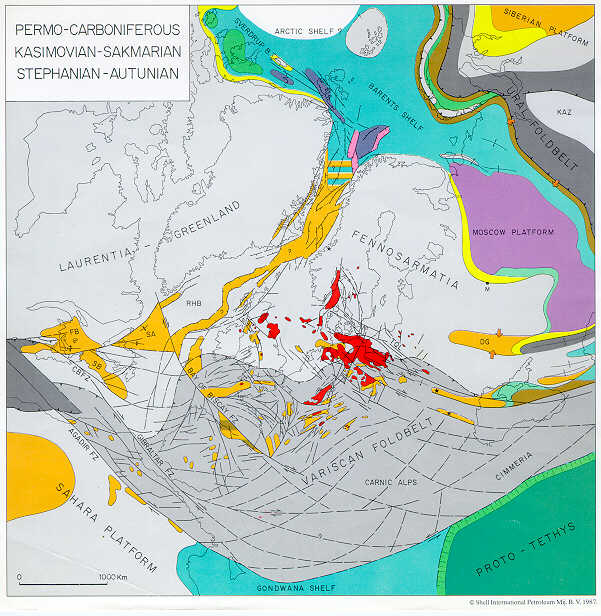
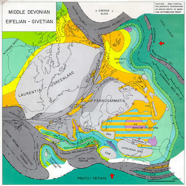
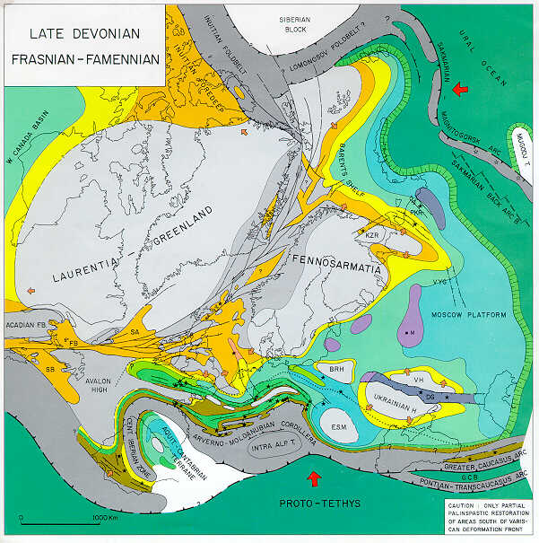
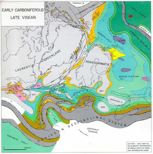
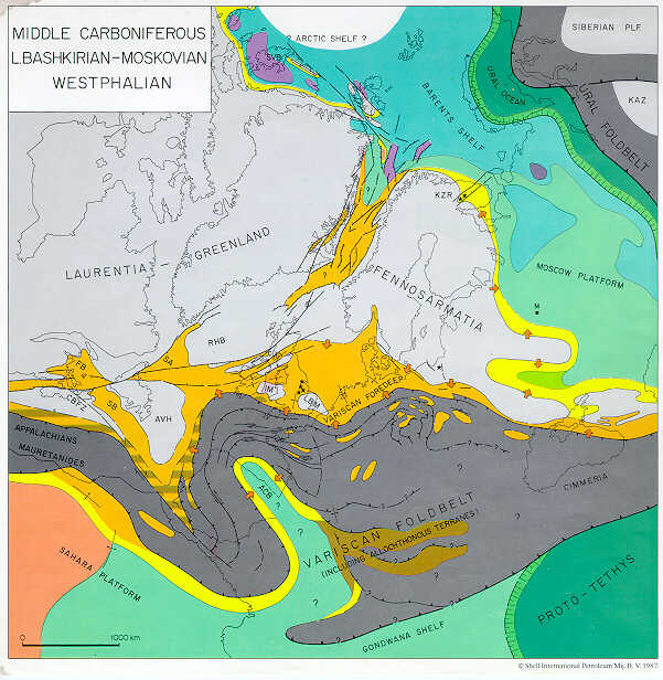
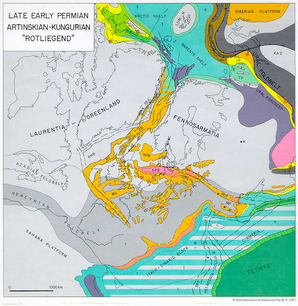
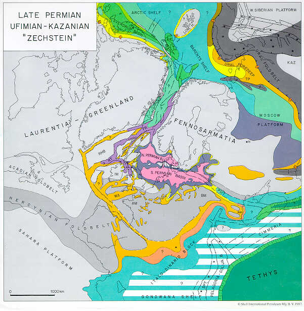
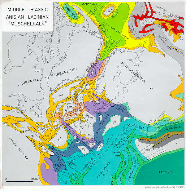
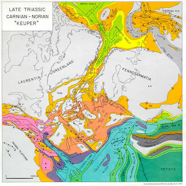
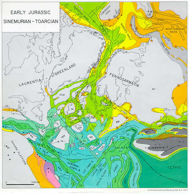
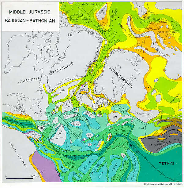
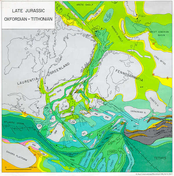
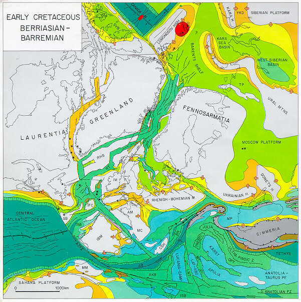
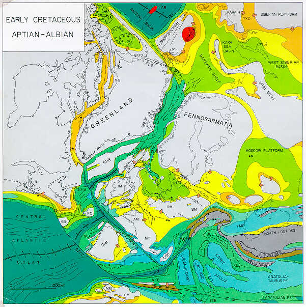
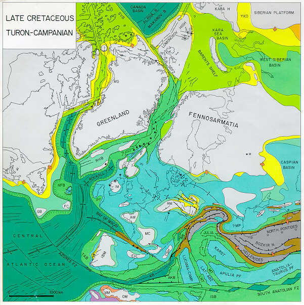
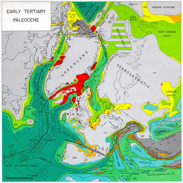
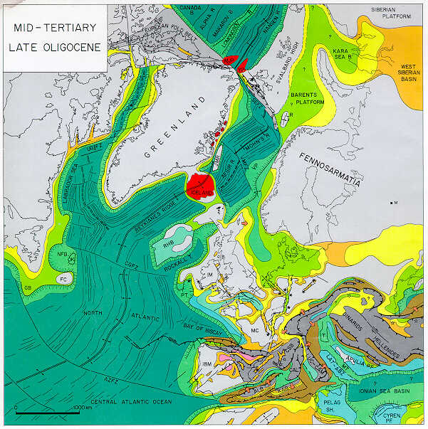
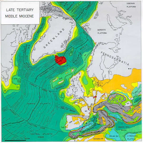
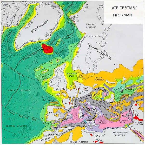
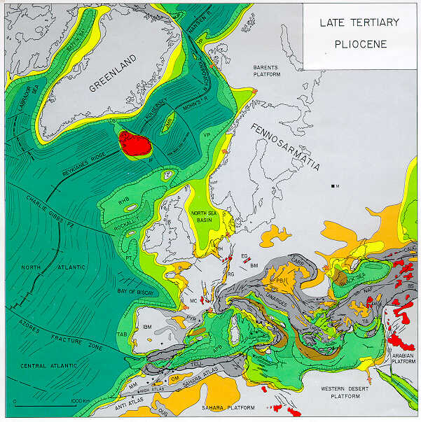
The individual paleotectonic-paleogeographic maps span large time intervals, and, in view of their scope, they are of an interpretative and in part even a conceptual nature. These maps give for the respective time interval maximum depositional basin outlines, gross lithofacies/depositional environment provinces in color code, and the principal tectonic features. For areas of nondeposition, a distinction was made between cratonic highs, tectonically active orogenic belts, and tectonically inactive fold belts characterized by a considerable topographic relief. Volcanic activity during the respective time interval is indicated by star symbols that distinguish between intraplate volcanism (black stars) and subduction-related volcanism (open stars). In view of the scope of these maps, depositional thickness values or isopachs could not be given; the reader is therefore referred to the literature quoted in the text.
The information given on the paleogeographic-paleotectonic maps was abstracted from more detailed maps that had been compiled for individual basins and provinces on the basis of in-house studies and/or published literature.
The topographic bases of these maps, showing the present-day continental outlines for areas not affected by orogenic activity during the respective time interval, are based on computer-generated palinspastic reconstructions of the Arctic-North Atlantic and the Central Atlantic Oceans as dictated by their sea-floor magnetic anomalies. These reconstructions were carried out at Shell Development Company's Bellaire Research Center in Houston using programs for computer animation of continental drift (Scotese et al., 1980). Devonian to Early Jurassic maps are essentially based on the predrift fit of the continents whereby paleomagnetic constraints were honored (Ziegler et al., 1979; Scotese et al., 1979, 1985; Morel and Irving, 1978). Empirical palinspastic corrections were applied to areas of important intracratonic deformation.
Projections are orthographic with the map center located in the northern part of Scotland. Because in many parts of the Central and North Atlantic, the Norwegian-Greenland and Labrador Sea, and Baffin Bay there is considerable uncertainty about the position of the continent-ocean boundary and the amount of crustal extension that occurred during the rifting phase preceding the opening of the respective ocean basins, the palinspastic reconstruction given in these maps should be regarded as tentative.
Furthermore, palinspastic reconstructions of the
Alpine-Mediterranean domain are based on the assumption that during the Late Carboniferous
and Permian the area between the African and European cratons was occupied by the
Hercynian fold belt and thus, by continental crust. In the eastern Mediterranean-Black Sea
area, the Hercynian fold belt probably faced the oceanic Proto- or Paleo-![]() Tethys
Tethys![]() , which
separated it from the northern, passive margin of Gondwana.
, which
separated it from the northern, passive margin of Gondwana.
The area occupied by continental crust at the end of the Hercynian
orogeny in the Western and Central Mediterranean domain was defined on the basis of the
late Paleozoic-early Mesozoic trans-Atlantic fit of Laurentia, Africa, and Fennosarmatia.
In the eastern Mediterranean-Black Sea area, the limits of the Proto-![]() Tethys
Tethys![]() Ocean during
the latest Carboniferous, and consequently the outlines of the Hercynian fold belt as
shown in the Permo-Carboniferous reconstruction given by Plate 6,
are conceptual.
Ocean during
the latest Carboniferous, and consequently the outlines of the Hercynian fold belt as
shown in the Permo-Carboniferous reconstruction given by Plate 6,
are conceptual.
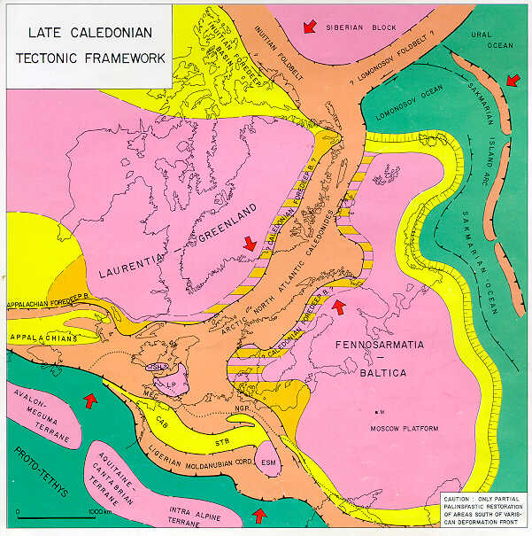
As a next step, areas corresponding to the Alpine-Mediterranean domain were subdivided into tectonostratigraphic units such that certain interpretations and assumptions had to be made regarding the correlation and original size of the different units recognized in the Alpine chains. Although the size and shape of the individual tectonostratigraphic units, such as the Italo-Dinarid promontory, had to remain tentative, their distinction and the retention of their dimensions formed the basis for the conceptual Late Permian, Mesozoic, and Cenozoic palinspastic reconstructions given in Plates 7-21. This approach was chosen for the simple reason that reliable palinspastic reconstructions are not yet available for the different segments of the Alpine fold belts in the Mediterranean area. Correspondingly, space allocation to the different tectonostratigraphic units has been arbitrary and is subject to perhaps major changes as new information becomes available. Furthermore, as the inventory of magnetic sea-floor anomalies increases, motions of the major cratonic blocks during the opening phases of the different segments of the Arctic-North Atlantic can be more closely constrained and a better understanding will be obtained of the width of oceanic basins that opened during the Mesozoic in the Mediterranean domain.
It should therefore be stressed that the
paleotectonic-paleogeographic maps presented in Plates 1 to 21 are generalized and that
they may have serious shortcomings. Yet they provide a first overview of the
post-Caledonian evolution of the entire Arctic-North Atlantic and Western ![]() Tethys
Tethys![]() areas and
their borderlands. As such, they are intended to give the reader a broad framework on
which to build and against which more local studies can be tested.
areas and
their borderlands. As such, they are intended to give the reader a broad framework on
which to build and against which more local studies can be tested.
The chronostratigraphic-lithostratigraphic correlation charts in Memoir 43 summarize the sedimentary record of selected basins and subbasins that developed through time in the Arctic-North Atlantic borderlands and in Western and Central Europe. Each chart provides the reader with an overview of the geological record of geographically and (generally) also genetically related basins, with color-coded depositional environments, erosional and nondepositional breaks, summary of the tectonic and igneous activity that accompanied the evolution of the respective basins and, where applicable, also their destruction, and the angularity of unconformities, whether they are rift or wrench induced or associated with folding.
The text of Memoir 43 is organized, from the point of view of plate
interaction, into a chronological account of the latest Silurian to Recent evolution of
the Arctic-North Atlantic and Western ![]() Tethys
Tethys![]() realms. Also there is a discussion of
geodynamic processes (included here as a modest revision of Chapter 10) that governed the
subsidence and destruction of sedimentary basins which evolved during the long and complex
geological history of the area under consideration. A summary of this discussion follows.
realms. Also there is a discussion of
geodynamic processes (included here as a modest revision of Chapter 10) that governed the
subsidence and destruction of sedimentary basins which evolved during the long and complex
geological history of the area under consideration. A summary of this discussion follows.
Legend for Plate 1.
Legend for Plates 2-21