Jonah Field: A Shallow Sweetspot in the Basin-Centered Gas Accumulation of the Northern Green River Basin, Wyoming
Kent A. Bowker, Chevron USA Production Company, Houston and John W. Robinson, Snyder Oil Corporation, Denver
Search and Discovery Article #10001 (2000)
Online adaptation of the above-titled paper, which is part of the Official Program Book and Expanded Abstracts Volume prepared for the 1997 Rocky Mountain Section, AAPG. This volume is available from the Rocky Mountain Association of Geologists, which holds the copyright and which kindly gave permission for this presentation. S&D editorial staff expresses its appreciation to Kent Bowker, who willingly agreed for this paper to be presented online and provided all data via FTP.
SUMMARY
Recently acquired data are beginning to illuminate the nature of the large, overpressured, basin-centered gas accumulation in the northern Green River Basin, Wyoming. Jonah field is a shallow, compartmentalized gas accumulation within the larger basin-centered accumulation.
The upper portion of the regional gas cell is within the Upper Cretaceous strata of the Lance Formation and Mesaverde Group. These units are composed of fluvial-channel sandstones and siltstones, floodplain shales and minor coals that were deposited on a broad alluvial plain between the Wyoming Thrust Belt and the then-emerging Wind River Mountains. Jonah field is located on the gentle northeast-dipping flank of the basin. Dispersed carbonaceous material and discontinuous coal beds within the Upper Cretaceous section are the sources of the hydrocarbons.
The upper boundary of the gas accumulation at Jonah coincides closely with the top of the Lance (± 8500 ft), whereas in other portions of the basin the top of the gas cell is near the top of the Mesaverde (± 10,500 ft). A fault that forms the abrupt southern boundary of the accumulation may hold the key to understanding the field. Fractures, formed in response to a left-lateral shear zone located at the southern boundary, may be the reason for the shallower accumulation and apparent higher permeability at Jonah verses other portions of the basin.
INTRODUCTION
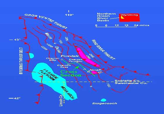
The basin-centered gas play of the northern Green River basin (sometimes referred to as the Hoback basin) has become one of the most active and exciting in the Rocky Mountain region. Over fifteen operators have been active in the play since the re-discovery of Jonah field by McMurry Oil Company in 1993 (Figure 1). A succinct history of the field’s development is published in Oil and Gas Investor (Klann, 1997). Jonah field is currently producing more than 100 MMCFGD (with associated condensate), with additional wells being drilled and placed on line monthly. There has also been an increase in activity on the nearby Pinedale anticline (Figure 1), a huge (and unique in the basin) foreland structure located on the far eastern edge of the basin. Wildcat wells have been drilled, or are planned, in every corner of the basin. Gas has been produced (and in some cases actually sold, as with Chevron’s Billy 33-16 and Ross 33-7) from wells located throughout the basin; but all efforts outside Jonah and Pinedale have lead to no real commercial success. Because there are no other Pinedale-type structures in the basin, current exploration efforts are concentrating on finding another Jonah-like accumulation. Therefore, having a thorough understanding of Jonah field is essential for prospecting in the northern Green River basin.
Most of the published work on the geology of the northern Green River basin was authored by Ben Law, Chuck Spencer and their colleagues at the USGS and is summarized in Law and Spencer (1989). These workers, following up on earlier work supported by the DOE (which was directed at using nuclear explosives to stimulate gas reservoirs at Pinedale and Merna; Martin and Shaughnessy, 1969), recognized the presence of up to a 5000 ft gas column in the Upper Cretaceous strata throughout the basin. Additional work on the Pinedale area was supported by the Gas Research Institute (Greenfield et al., 1981). Recent reports on Jonah include Montgomery and Robinson (1997) and Finch et al. (1997). The recent drilling in the basin has shown that the petroleum geology of the basin is much more complex than believed previously. For example, the top of the basin-centered gas cell has much more "topography" than was recognized previously and the top does not correspond to either the current or past geothermal gradients.
STRATIGRAPHY, SEDIMENTOLOGY AND PETROLOGY
The huge basin-centered gas accumulation is present within overpressured Upper Cretaceous fluvial strata of the Lance Formation and upper Mesaverde Group (Ericson Sandstone and Rock Springs Formation; Figure 2). The Tertiary Ft. Union Formation, which is normally pressured and is not part of the basin-center gas cell, may also prove productive in some portions of the basin. The Almond Formation is not present in most of the northern Green River basin; the northernmost occurrence of Almond bar sandstone appears to be at Stagecoach field (Figure 1). The Lance ranges in thickness from a zero-line on the east flank of the La Barge uplift to over 5500 ft thick below the leading edge of the Wind River thrust. The upper Mesaverde is partially truncated by the K-T unconformity at the eastern edge of the La Barge uplift where it is less than 1000 ft thick, but thickens to over 3500 ft at the Wind River thrust. The upper Mesaverde has tested gas in several areas of the basin, but it has not proven to be a commercial producer.
The Lance and upper Mesaverde are composed of fluvial channel sandstones and siltstones, floodplain shales, and minor coals that were deposited in a broad alluvial plain located between the Wyoming Thrust Belt and emerging Wind River Mountains (Figure 1). Sediment transport was generally to the southeast and east. Individual sandstone units average 25 ft thick, with some amalgamated sandstone packages more than 100 ft thick.
Lance and upper Mesaverde sandstones range from predominantly litharenite to sublitharenite, with chert making up most of the lithic grains. Most of the sandstones are very fine grained, but they can grade up to medium grained in the basal portion of channel-fill deposits. Channel lag, containing a large percentage ripped-up clasts of overbank muds, are also common in the basal portions of channel fill units. These channel-lag horizons can be mistaken for shale beds when examining a gamma ray log across the interval.
The Lance sandstones at Jonah average 80% quartz (including chert grains), 3% calcite, 2% feldspars, 1% dolomite and 14% clay minerals. Of the clay fraction, chlorite and illite both average 40%, with kaolinite and occasionally a trace of smectite making up the remaining portion.
RESERVOIR PROPERTIES
Productive sandstones in the Lance Formation at Jonah are extremely tight. Porosity in pay zones ranges from 8 to 12% and in situ permeability (measured from pre-frac pressure-transient tests) ranges from 3 to 20 microdarcys. In upper Mesaverde sandstones that have tested gas, the porosity is between 8 and 10%. The one pre-frac pressure-transient test run in the Mesaverde (Chevron, Billy 33-16) indicates a permeability of 8 microdarcys. Pore-throat radii in productive Lance intervals at Jonah average 0.3 microns. The only water production at Jonah is "dew," which forms in response to the pressure drop when the gas is produced, and indicates that the reservoir is at irreducible water saturation (about 25% to 35% Sw). Mercury injection-based capillary pressure curves indicate that, to obtain water saturation at irreducible in rock this tight, the gas column must be greater than 2000 ft.
Few natural fractures have been observed in the limited Lance cores and imaging logs from Jonah field. However, fractures (or some other permeability-enhancing mechanism) must be present in the reservoir to account for the production rates seen in the field.
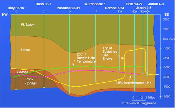
Pore-pressure gradients within the gas-saturated cell at Jonah range from 0.55 to 0.70 psi/ft. At Merna (Figure 1), a gradient of 0.97 psi/ft was reported at the base of the Mesaverde (Spencer, 1983). The top of the overpressured gas cell appears to coincide with the top of sustained gas shows, however, sustained gas shows may simply indicate increased permeability within the overpressured cell. The upper boundary of the gas accumulation in Jonah coincides closely with the top of Lance (± 8500 ft), whereas in other portions of the basin the top of the gas cell is near the top of the Mesaverde Group (± 10,500 ft) (Figure 3). Jonah field and the Pinedale anticline are the only areas where the top of sustained gas shows has been found above 10,500 ft.
STRUCTURAL GEOLOGY
The northern Green River basin is a simple NW-SE trending asymmetric basin with a gentle northeast-dipping west flank. The Pinedale anticline is the only major structural inversion in the basin. There are relatively minor anticlinal flexures at Merna and Daniel (Figure 1). All of these features are of Laramide age but they don’t involve basement rocks directly, though the structural grain imposed by basement lineaments may have affected the location of these thin-skinned structures. The youngest structural feature in the basin is the Continental Fault, a down to the WSW normal fault located just west of the Wind River thrust. The Continental fault may indicate that the basin is currently under Wasatch-influenced, west-directed extension. Jonah field is located on the basin’s northeast-dipping homocline, which dips 425 ft/mile. Acquisition of a proprietary 3-D seismic survey over the field has added greatly to our understanding of the influence of structure on gas production. A left-lateral strike-slip fault zone (again, thin-skinned) forms the southern boundary of Jonah. This fault zone also appears to bound the south plunge of the Pinedale anticline. Across this fault zone there is 2500 ft of relief on the top of the overpressured gas cell (Figure 3). Other faults are observed in the seismic data, and some of these may form the productive limits on the other margins of the field.
HYDROCARBON SOURCE AND GENERATION
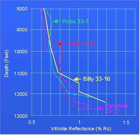
Dispersed carbonaceous material and discontinuous coal beds within the Lance and upper Mesaverde are the source of hydrocarbons found within these strata. Early in the study of Jonah, it was believed that very little, if any, hydrocarbon migration had taken place and that the relatively shallow gas accumulation at Jonah was a result of a thermal hot-spot; i.e., the critical maturation temperature (about 250° F) was reached higher in the sedimentary column at Jonah relative to other portions of the basin, resulting in a shallower accumulation. Wellbore temperature and vitrinite reflectance data collected by Chevron and Snyder show, however, that there isn’t, nor has there been, a thermal anomaly at Jonah (Figure 3). Throughout the basin, gas produced from the Mesaverde and lowermost portions of the Lance becomes isotopically heavier with depth, supporting the contention that very little migration has taken place (and that the gas is sourced from Type III, or coaly, organic matter), that is except for the middle and upper Lance at Jonah. Limited stable-isotope data from Jonah indicate that the gas produced from this interval does not show this "heavier with depth" trend. In addition, this shallower gas is produced from above the 0.8 Ro line (believed to mark the onset of gas generation and migration from Type III organic matter) (Figure 3). Hence, the gas being produced at Jonah appears to have migrated from sources lower in the Lance or upper Mesaverde.
Vitrinite-reflectance profiles across the basin are similar (Figure 4) and show a consistent rate of maturation to a depth of 11,000 ft, where the rate of maturation increases suddenly. Law et al. (1989) also noted this "kinky" vitrinite- reflectance profile in the northern Green River and other Larimide basins. Burial history curves for the basin suggest the onset of generation in the early Tertiary; hydrocarbon generation ceased with the widespread Pliocene exhumation of the Rockies. Produced gases from wells located throughout the basin have a high percentage of C2+ components (with the concentration of heavier hydrocarbons increasing with depth, even in the upper and middle Lance at Jonah) and may be close to the dewpoint throughout the pressure cell; i.e., the entire pressure cell may be a retrograde gas reservoir.
DISCUSSION AND CONCLUSIONS
The origin of the sweetspot at Jonah field is not completely understood, but additional development and step-out drilling and interpretation of 3-D seismic will allow us to put a clearer picture together. Existing data preclude interpretation of a classic structural or stratigraphic trap at Jonah. Borehole temperature data taken from static pressure surveys indicate that there is no thermal anomaly at Jonah that could have formed a localized generation window (Figure 3). There is no systematic variation in sandstone petrology or gross sandstone isopachs in the Lance Formation that would form a classic stratigraphic trap.
Several key factors are thought to contribute to the presence of Jonah field. There is an abrupt southern limit to the field where the top of sustained gas shows changes depth from 8500 ft to 11,240 ft in wells drilled 0.5 mile apart (Figure 3). This change is enigmatic but could be the result of several factors, including: isolation of the pressure compartment by a lateral seal such as a fault or shear zone, a decrease in permeability caused by diagenesis, or a breach of the top seal by faulting or non-deposition of the sealing horizon. There are no long-term pressure build-up data available from wells south of the field, so it is not certain if the pressure cell actually deepens to the south, however, information collected during drilling (drilling rates and gas shows) and completion operations (pump-in pressures) indicate the Lance is less permeable where sustained gas shows are lacking. Explaining the abrupt southern boundary of Jonah is probably the key to understanding the origin of the field.
Based on limited core data, fracture stimulation pressures and production profiles, the Lance reservoir appears to be fractured. Pre-frac pressure-transent tests from wells both in and out of Jonah indicate that the Lance and upper Mesaverde have in situ matrix permeabilities of 3 to 20 microdarcys. This suggests that fractures play a significant role in gas deliverability and may be the cause of the 2500 ft-thick gas column at Jonah. Wells at Jonah have to be massively frac-stimulated to achieve economic flow rates. These fracs probably connect the wellbore to the natural fractures. In wells located outside Jonah, there is no fracture network with which to connect the wellbore, hence these wells (even though they too are frac stimulated) are uneconomic. The natural fractures probably formed in response to left-lateral shear along a fault/shear zone that trends west-southwest out of the Wind River Mountains and defines the southern boundary of the field (Figure 1). This fault is part of the far-field transmission of stress related to the emplacement of the Pinedale and Wind River thrusts. Stress within the allochthon (the block on the north side of the fault) generated the fractures.
The top of any basin-center gas deposit is defined by the point where the sum of the buoyancy and pore pressures within the underlying gas-saturated sedimentary column is matched by the capillary pressure of the overlying water-saturated column. At Jonah, this regional balance was upset by the fracturing (and, hence, increased permeability) created by movement along the left-lateral fault zone described above: gas migrated up through the fractures into the now more permeable rock (more permeability means lower capillary pressure) of the middle and upper Lance until it reached a new equilibrium point.
The presence of a basin-centered gas accumulation in Cretaceous strata in the northern Green River basin has been known for many years, but the gas was considered to be an uneconomic resource due the depth of the accumulation. The discovery of Jonah field demonstrates that pressure compartments, with up to 2500 ft of gas-saturated section, can exist above the regional gas accumulation. Such compartments may be a new and under-exploited type of target in many Rocky Mountain basins. Understanding the Jonah sweetspot is a key to prospecting for similar sweetspots in overpressured, basin-centered structural settings worldwide.
REFERENCES
Finch, R.W., W.W. Aud and J.W. Robinson, 1997, Evolution of completion and fracture stimulation practices in Jonah field, Sublette County, Wyoming: Rocky Mountain Assoc. of Geologists Guidebook of Oil-field Technologies in the Rocky Mountains, in press.
Greenfield, H., U. Ahmed, M.T. Holland and J.F. Schatz, 1989, Resource evaluation and production research on tight sands in the Pinedale unit, Sublette County, Wyoming: GRI Final Report 81/0049, 157 p.
Klann, S., 1997, Jonah’s tale: Hart’s Oil and Gas Investor, 17, no. 6, 63-66.
Law, B.E., and C.W. Spencer, eds., 1989, Geology of tight gas reservoirs in the Pinedale anticline area, Wyoming , and at the multiwell experiment site, Colorado: US Geological Survey Bulletin 1886.
Law, B.E., V.F. Nuccio and C.E. Barker, 1989, Kinky vitrinite reflectance well profiles: evidence of paleopore pressure in low-permeability, gas-bearing sequences in Rocky Mountain foreland basins: AAPG Bulletin, 73, 999-1010.
Martin, W.B. and J. Shaughnessy, 1969, Project Wagon Wheel: Wyoming Geological Assoc. Guidebook, 21, 145-152.
Montgomery, S.L., and J.W. Robinson, 1997, Jonah field, Sublette County, Wyoming: gas production from overpressured Late Cretaceous Lance sandstones of the Green River basin: AAPG Bulletin, 81, no. 7.
Spencer, C.W., 1983, Overpressured reservoirs in the Rocky Mountain region [abs.]: AAPG Bulletin, 67, 1356-1357.
Figures
Figure 1. Index and structure map of top Lance Formation, northern Green River basin. Line of cross section (Figure 3) is shown.