![]() Click to view article in PDF format. (9.73 MB)
Click to view article in PDF format. (9.73 MB)
Tectonic Control on Major ![]() Hydrocarbon
Hydrocarbon![]() Accumulations in
Accumulations in
Dhansiri Valley, Assam and Assam Arakan Basin, India*
Ram Krishna Singh1, Pratim Bhaumik1, M.S. Akhtar1, H.J. Singh1, Sanjive Mayor1, and Manoj Asthana1
Search and Discovery Article #30148 (2011)
Posted March 14, 2011
*Adapted from oral presentation at AAPG International Conference and Exhibition, Calgary, Alberta, Canada, September 12-15, 2010
1Basin Research Group KDMIPE ONGC, Dehradun-India, 248001 ([email protected])
Dhansiri Valley, constituting the southern part of Assam shelf of Assam and Arakan Basin, is a commercial ![]() hydrocarbon
hydrocarbon![]() producing province. The Assam Shelf consists of sedimentary rocks ranging in age from Permian to recent. These are distributed approximately over 57,000 sq. km. The maximum thickness is nearly 5 km in the deeper part of the Dhansiri Valley. The setting is primarily of a southeast-dipping shelf which is over-thrust by the Himalaya Mountain Range in the north and Naga Hills in the southeast, with the NE-SW trending Assam Shelf sandwiched between these two orogenic belts.
producing province. The Assam Shelf consists of sedimentary rocks ranging in age from Permian to recent. These are distributed approximately over 57,000 sq. km. The maximum thickness is nearly 5 km in the deeper part of the Dhansiri Valley. The setting is primarily of a southeast-dipping shelf which is over-thrust by the Himalaya Mountain Range in the north and Naga Hills in the southeast, with the NE-SW trending Assam Shelf sandwiched between these two orogenic belts.
The tectonic evolution of the Dhansiri Valley is through rift, drift and collision stages. The sedimentary record of rift sediments is preserved in grabens, while the drift and collision stages are characterized by the passive margin and foreland sequences respectively. The entrapment of hydrocarbons in this poly-tectonic sub-basin is almost at all the stratigraphic levels including fractured basement. The occurrence of hydrocarbons in major fault blocks is at different stratigraphic levels. The ![]() hydrocarbon
hydrocarbon![]() producing reservoirs are sandstone and range from Paleocene to Miocene age; the fractured basement is of Precambrian age. Thick carbonaceous shale of Upper Eocene age is the source rock for the generation of hydrocarbons in the study area.
producing reservoirs are sandstone and range from Paleocene to Miocene age; the fractured basement is of Precambrian age. Thick carbonaceous shale of Upper Eocene age is the source rock for the generation of hydrocarbons in the study area.
This study indicates that the major accumulations of hydrocarbons in Dhansiri Valley are at a deeper stratigraphic level near the Schuppen Belt, in horst-graben settings and relatively lesser accumulations are at a shallower stratigraphic level away from the Schuppen Belt accumulated in the hanging wall of compressive structures. The accumulations are essentially controlled by the tectonic ![]() elements
elements![]() , even the lenticular sands charged with hydrocarbons occur only at the structurally highest part. This study helps identify likely potential areas of
, even the lenticular sands charged with hydrocarbons occur only at the structurally highest part. This study helps identify likely potential areas of ![]() hydrocarbon
hydrocarbon![]() prospects in the study area.
prospects in the study area.
Copyright � AAPG. Serial rights given by author. For all other rights contact author directly.
|
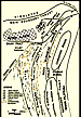
Dhansiri Valley is bounded to the east and southeast by the Naga Thrust, in the west by the Mikir Hills and Shillong Plateau and to the north by Jorhat Fault (Figure 2). It consists of sedimentary rocks ranging in age from Permian to recent. The thickness of Tertiary sediments in Dhansiri Valley ranges from 1400 to 4200 m and the thickness increases southeastward. The maximum sedimentary thickness of nearly 5 km are expected below the Schuppen Belt (Figure 2a).
The success of
The
Tectonically the Assam and Assam Arakan Basin is subdivided in to Shillong Massif (Shillong Plateau) and Mikir Massif (Mikir hills), Himalayan frontal fold belt (Himalayas), Mishmi Massif (Mishmi hill), Assam Shelf, Schuppen Belt (Evans, 1964), Indo-Burmese Ranges (Assam-Arakan Ranges) and Compressed thrust fold belt (CTFB) of Tripura-Cachar-Mizo folds (Figure 2) and the Eastern Belt of metamorphics including the Ophiolite Belt.
The
sedimentary rocks in the Shillong Plateau area rest over the Precambrian
crystalline basement and were studied by the Geological Survey of
India. Subsequent drilling has proven the extension of these rocks
in the subsurface of Assam Shelf. It has been inferred from the various
studies that ENE-WSW and NW-SE trends are the two dominant trends
in the exposed basement. The intensely fractured and highly weathered
basement (Ranga Rao, 1983; Bastia et al., 1993) has been producing
from Borholla-Changpang fields in the study area. The detailed stratigraphy
and
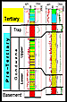
Dhansiri Valley has under gone more than one phase of tectonics and sedimentation processes. The evolution of the basin is influenced by the movement of the Indian plate in relation to the Eurasian and Burmese plates. The sediments in Dhansiri Valley have been deposited during rift, drift and collision phases of the Indian plate. The oldest sediments in the study area are the Gondwana sediments restricted in grabens. These are followed by the Paleogene sediments deposited in passive margin setting, and the deposition of Neogene and Quaternary sediments in foreland settings.
Rift Setting (Gondwana Sediments)
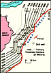
Pre-Tertiary sediments equivalent to Gondwana age have been encountered in the northern part around the Dergaon area and in the southern part including Barpathar, Jamuguri, East-Lakhibari, Farkating, and Gamariguri structure in the study area. These sediments are preserved in narrow grabens oriented in a NE-SW direction (Figure 3b). The palynological studies of these sediments suggest Permian to Early Cretaceous age (Singh et al., 1986; Sharma et al., 1986; Ramesh et al., 2003). The whole Gondwana sequence is characterized by alternations of argillaceous sediments (claystone, siltstone and shale) marked by high resistivity 100-200 ohmm and fluctuating GR on logs (Figure 3a). Pre-Tertiary strata, though recognized only in a few restricted areas of Assam Basin, represent an important phase of tectonic evolution and also form a potentially, yet untested, petroleum system concept in northeastern India (Naik et al., 2004).
Pre-Tertiary rocks have also been reported from surface exposures in the Singrimari area of Garo Hills (District Goalpara), South Shillong Plateau. These consist of gritty sandstones with carbonaceous shale and presence of typical Lower Gondwana plant fossils, viz. Vertebrartia indica and gymnospermous rhizomes, etc.
Passive Margin Setting (Paleogene Sediments)
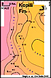
The Paleogene is represented by sediments of the Jaintia Group (Paleocene to Eocene) and Barail Group (Oligocene) (Figure 2b). Jaintia Group includes sediments of the Tura (Upper Paleocene-Lower Eocene), Sylhet (Middle Eocene), and Kopili (Upper Eocene) formations, whereas Barail Group (Oligocene) includes sediments of Barail Formation (Figure 3c). The thickness of Paleogene sediments varies from 300 to 900 m and increases towards the southeast (Figure 3d). The lowermost sedimentary layer is the Tura Formation, resting either on the granite gneiss, the trap, or the Gondwana, depending on position and area of the basin.
The Tura Formation is represented by calcareous sandstones with basal conglomerate which were deposited in fluvial to shallow marine environments. The Sylhet Formation consists of fossiliferous limestone with shale and sandstone bands and these sediments have been deposited in a shallow marine shelf environment. The clastic intercalations within the Sylhet Formation represent periods of regressive impulses. The Kopili Formation consists of transgressive shale with intercalations of fine-grained sandstone and marl streaks, deposited in a shallow marine environment.
The Barail Formation is sub-divided into two parts, the lower part composed of fine-grained cross bedded massive sandstone known as Barail Main Sand (BMS) and the upper part consists of shale, coal seams and a few channel sands is known as Barail Coal Shale (BCS). These sediments were deposited in shallow marine, deltaic, swampy and fluvial environments. The end of the Paleogene is marked by the widespread Oligocene unconformity and sediments equivalent to the Barail Coal Shale (Upper Oligocene) have been eroded in the study area.
Foreland Setting (Neogene and Quaternary Sediments)
The Neogene sediments (Miocene-Pliocene) include sediments of Surma (Lower-Middle Miocene), Tipam (Upper Miocene) and Moran (Pliocene) groups, from bottom to top (Figure 2b). The thickness of Neogene sediments varies from 800 to 2600 m and increases towards the southeast (Figure 3f). The sediments of Surma, Tipam and Moran groups correspond to the respective Bokabil, Tipam and Namsang formations (Figure 3e).
Sediments of the Bokabil Formation, and in some places the Tipam Formation, either rest on Barail Main Sand or Barail Coal Shale of the Barail Group. Sediments of the Bokabil Formation (Lower-Middle Miocene) consist of predominantly mudstone, siltstone and thin sands streaks in between. These sediments were deposited in a shallow marine environment.
Sediments of the Bokabil Formation are overlain by the sediments of the Tipam Formation (Upper Miocene) which consists of predominantly sandstone with some thin clay bands. These have been deposited in fluvial environments and are overlain by the sediments of the Namsange Formation. The Namsang Formation (Pliocene) consists of unconsolidated sand, intercalated with clay and lignite. The sediments have been deposited in the fluvial environment and are followed by sands, silts and clays of Post-Namgang (Quaternary).
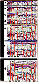
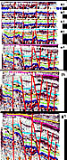
Paleo-strutural analyses have been attempted along the NE-SW direction and NW-SE across Dhansiri Valley using 3D seismic data calibrated with the wells to understand the paleo-tectonic and depositional history of the area. The paleo-structural analyses have been attempted at reflectors corresponding to the top of Sylhet Formation (Middle Eocene), Kopili Formation (Upper Eocene) and Barail Formation (Lower Oligocene) for the Paleogene section, and Bokabil Formation (Lower to Middle Miocene ), Tipam Formation (Upper Miocene) and Namsang Formation (Pliocene) for the Neogene section.
End of Sylhet Formation (Middle Eocene)
The seismic reflector near the Sylhet Formation top has been flattened along the NE-SW and NW-SE directions. Neither directions indicate active tectonics. The Sylhet Formation consists of predominantly carbonate and at places having intervening shale and sand. These carbonates have been deposited in a relatively calm and quite depositional environment. The occurrences of shale and sand in between are due to fluctuation in the sea level. The rise of sea level is associated with the deposition of shale, and fall of sea level to deposition of sand (Figure 4a).
End of Kopili Formation (Upper Eocene)
The seismic reflector corresponding to the Kopili Formation top has been flattened along the NE-SW and NW-SE directions. It indicates that there has been reactivation and subsidence along F2, F3 and F5, observed in NE-SW directions, (Figure 4b) and subsidence in between f5 to f3, and compression between f3-f1 have been observed in NW-SE directions (Figure 4b1) during deposition of the Kopili Formation. The Kopili Formation consists of predominantly shale with minor sand, deposited in marine conditions. The occurrence of sands within shale is attributed to the intermittent fall in sea level due to reactivation of faults (Figure 4b).
End of Barail Formation (Lower Oligocene)
The seismic reflector corresponding to the Barail Formation top has been flattened along the NE-SW and NW-SE directions. It indicates there has been reactivation of F3, F5 and F8 faults, uplift of the block between F5 and F9, and subsidence of the block between F3 and F5 in NE-SW section (Figure 4c). Subsidence along f5, and compression between f5 to f1 has been observed in the NW-SE section (Figure 4c1). These have resulted in erosion of uplifted blocks and deposition in nearby subsided areas. Lesser or absence of Barail sediments indicate uplifted area, while relatively thicker Barail sediments indicate subsided areas (lows) during the Oligocene. The end of Barail Formation is marked by major unconformity in the area (Figures 4c and 4c1).
End of Bokabil Formation (Lower to Middle Miocene)
The seismic reflector corresponding to the Bokabil Formation top has been flattened along the NE-SW and NW-SE directions. It indicates extensive faulting and reactivation of pre-existing faults followed by subsidence along F2, F3, F5 and F6 in the NE-SW direction. Reactivation of almost all the faults and major subsidence along f3 and f5 have been observed in the NW-SE direction. These have resulted in erosion of uplifted areas and deposition of eroded sediments into nearby subsided areas (Figures 4d and 4d1).
End of Tipam Formation (UpperMiocene)
The seismic reflector corresponding to the Bokabil Formation top has been flattened along the NE-SW and NW-SE directions, and indicates relatively less tectonic activity in the area. Reactivation and subsidence along F2 and F3 faults and compression along F4 fault have been observed in the NE-SW direction. Reactivation of almost all the faults and major subsidence was observed along f3, f5 and f6 in the NW-SE direction. The end of Upper Miocene is marked with the formation of structural traps (Figures 4e and 4e1).
End of Namsang Formation (Pliocene)
The seismic reflector corresponding to the Namsang Formation top has been flattened along the NE-SW and NW-SE directions. It indicates reactivation of F1, F2 and F6 in the NE-SW direction. Subsidence along f3 and active subsidence and deposition of thick Namsang Formation in the SE part have been observed in the NW-SE direction. Overall the area has been subjected to regional compression and is depicted by bulging of younger stratas’ special curvature at the top of Tipam Formation, indicating compression during Pliocene (Figures 4f and 4f1).
Present Day
The curvature at the top of Namsang Formation indicates the continued compression from the SE direction followed by reactivation of F1, F2 , F6 and f3 as observed in NE-SW and NW-SE sections respectively. Presently these faults appear in the state of active subsidence and receiving sediments. The subsidence is attributed to relative uplift of the Mikir Massif and compression from Naga Thrust (Figure 4g and 4g1).
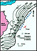
(a) Source Rock The source rock studies indicate that thick, shallow marine carbonaceous shales of Kopili Formation (Upper Eocene) have average TOC values ranging between 2-8% and HI value varies from 100-300, suggesting type III kerogen. The Tmax values range from 410-450º C indicating that Kopili sediments are well within the oil window and confirm the presence of mature source rock. The organic richness and their maturity increases towards the Schuppen Belt (Singh et al., 2008). The gross thickness of Kopili sediments varies from 50-300 m with a gradual thickening towards the southeast (Figure 5).
(b) Reservoir Rock The sandstone within the Bokabil (Lower Miocene), Tura (Upper Paleocene-Lower Eocene), Sylhet (Middle Eocene), and Kopili formations (Upper Eocene) have good reservoir characteristics, besides the fractured basement of Precambrian age. The thickness of multilayered sandstone reservoirs within Sylhet and Kopili formations varies from 2 to17 m, with porosity variations from 11-29%. The thickness of lenticular sands within Bokabil Formation varies from 3 to 12 m, with porosity variation between 15-21% (Figures 6a-6c).
The sandstone layers within the Tura and Sylhet formations are proven
(c) Cap Rock/Seal Shales of the Kopili Formation act as lateral seals in host-graben settings for fractured basement reservoirs. Shale at the top of each reservoir sand within the Tura, Sylhet, Kopili, Bokabil formations act as seals for different reservoirs in the area.
Major
Borholla-Changpang, Khoraghat and Nambar are the major producing fields from Dhansiri Valley which account for more than 90% of the proven
1) Faulted horst and graben 2) Inverted normal fault 3) Compressed normal fault
1) Faulted Horst and Graben Structure The
analysis of geo-scientific and production testing data of Borholla-Changpang
Field indicates that the hydrocarbons have been trapped in the basement
involved “Faulted Horst and Graben” type structure (Figures
7a,7b,7c
and 7d). Where thick shale
of the Kopili Formation, and at places shale and limestone of Sylhet
Formation, juxtapose against the fractured basement (Figure
7d) an ideal trap for
2) Inverted Normal Fault The
analysis of geo-scientific and production testing data of another
major producing field “Khoraghat Main Field” indicates that the hydrocarbons
have been trapped in the inverted hanging wall of the Khoraghat main
structure (Figures 8a, 8b,
8c and 8d).
The
3) Compressed Normal Fault The
analysis of geo-scientific and production testing data of another
major producing field “Nambar Field” indicates the hydrocarbons have
been trapped in the compressed hanging wall, down-thrown side of Nambar
structure (Figures 6a and 6b,
Figures 9a
and 9b). The
The
Bokabil Formation consists of shale with lenticular sands in between.
The upper part of Bokabil Formation is composed of thick shale with
minor sandstone, whereas the lower part of the Bokabil Formation is
composed of alternating lenticular sands and shale. The (Figure 10b) and in younger stratigraphic levels away from it, largely associated with hanging walls of compressive structures (Figure 10a).
The
(Figure 10b). The majority of the discovered hydrocarbons in Neogene reservoirs (mostly Miocene) are located away from the Naga-Schuppen Belt in the hanging-wall block of the structures (Figure 10a).
●
● The Kopili shale is a mature source rock and is well within the oil window. The maturity of Kopili shale increases towards the Schuppen Belt.
● It has been observed from studies that cross faults act as conduits for
● The thick shale of the Kopili Formation and Sylhet Formation (at places) juxtaposing against the fractured basement in horst and graben structures form ideal traps for
● Folding in successive overlying Tura, Sylhet and Kopili formations over tilted fractured basement forms favorable structural entrapment conditions for hydrocarbons in these formations.
● Analysis indicates that hydrocarbons accumulated in the crestal part of the inverted hanging wall in the Khoraghat main structure.
● Analysis indicates that hydrocarbons accumulated in the crestal part of the compressed faulted down-thrown side of the hanging wall in the Nambar structure.
● The
The opinions expressed in this paper are of the authors not the organization they belong to.
Authors are grateful to Shri D.K. Pande, Director (Exploration) and Shri P.K. Bhowmick, ED-Head KDMIPE for their constant encouragement, guidance and according permission for presentation and publication.
Bastia, R., G.C. Naik, and P. Mohpatra, 1993,
Das, K.C., V.S.B. Sarma, and M. Ayyadurai, 2004, Gondwana Sediments: A Promising
Evans, P., 1964, The Tectonic framework of Assam: Geological Society of India Journal, v. 5, p. 80-96.
Naik, G.C., Kumar Rajiv, and M.N. Soren, 2004, Tectonic Setting and Petroleum System Significance of Pre-Tertiary Sediments, Assam Basin, Northeast India: 5th Conference and Exposition on Petroleum Geophysics, Hyderabad, India, p. 365-371.
Rao, A.R., 1983, Geology and
Singh, R.K., P. Bhaumik, M.S. Akhtar, H.J. Singh, S. Mayor, and M. Asthana, 2010, Major
Singh, Ram Krishna, P. Bhaumik, M.S, Akhtar, A. Siawal, and H.J. Singh, 2008, Petroleum System of Dhansiri Valley - An Example from Shelf and Fore Land Setting Assam and Assam Arakan Basin-India, Geo India Conference & Exhibition, Greater Noida, New Delhi, September 16-19.
Singh, R.K., P. Bhaumik, M.S. Akhtar, A. Siawal, and H.J. Singh, 2008, Tectono-Sedimentation and
Singh, R.K. P. Bhaumik, M.S. Akhtar, A. Siawal, and H.J. Singh, 2008, Deeper (Paleogene)
Tewari, P.K., R.K. Singh, R.K. Thakur, and G. Joshi, 2000, Migration trends in Borholla-Chagpang Field-Assam foreland Basin, India, in (eds) A.K. Garg, V. Banerjie, S.N. Swamy, and P. Dwivedi, Petroleum Geochemistry and Exploration in the Afro-Asian Region: Proceedings of the Fifth International Conference and Exhibition on Petroleum Geochemistry and Exploration in the Afro-Asian Region, New Delhi 25-27 November 2000: B.R. Publishing Corp., New Delhi, India, book 612 p. |