Click to view article in PDF format.
Evaluation of the Regional Top ![]() Seal
Seal![]() for the Purpose of Geologic Sequestration
for the Purpose of Geologic Sequestration
in the Gippsland Basin, Southeastern Australia*
Louise Goldie Divko1, Joseph Hamilton2, and Geoffrey W. O’Brien1
Search and Discovery Article #80099 (2010)
Posted September 24, 2010
*Adapted from poster presentation at AAPG Convention, New Orleans, Louisiana, April 11-14, 2010
1Department of Primary Industries, GeoScience Victoria, Melbourne, VIC, Australia ([email protected])
2AMMTEC Limited, Perth, WA, Australia
GeoScience Victoria and partners have undertaken the first detailed basin-wide study of the regional top ![]() seal
seal![]() , the Lakes Entrance Formation, in the Gippsland Basin. The Gippsland Basin is a prolific hydrocarbon province with some major oil fields nearing the end of their productive life. Within the onshore portion of the basin are coal-fired power stations which generate significant greenhouse gas emissions. The Gippsland Basin presents an attractive site for the possible geologic sequestration of carbon dioxide because of the close proximity to emission sources and the potential for large scale storage projects. This comprehensive assessment of the regional top
, the Lakes Entrance Formation, in the Gippsland Basin. The Gippsland Basin is a prolific hydrocarbon province with some major oil fields nearing the end of their productive life. Within the onshore portion of the basin are coal-fired power stations which generate significant greenhouse gas emissions. The Gippsland Basin presents an attractive site for the possible geologic sequestration of carbon dioxide because of the close proximity to emission sources and the potential for large scale storage projects. This comprehensive assessment of the regional top ![]() seal
seal![]() has involved the analysis of the geometry of the
has involved the analysis of the geometry of the ![]() seal
seal![]() (the geographic extent, depth to base and
(the geographic extent, depth to base and ![]() thickness
thickness![]() of
of ![]() seal
seal![]() );
); ![]() seal
seal![]() capacity (calculated vertical column heights from Mercury Injection Capillary Pressure analysis) and mineralogical composition of the
capacity (calculated vertical column heights from Mercury Injection Capillary Pressure analysis) and mineralogical composition of the ![]() seal
seal![]() (from Automated Mineral Analysis). These datasets have been integrated to produce a qualitative evaluation of the containment potential for geologic sequestration across the basin.
(from Automated Mineral Analysis). These datasets have been integrated to produce a qualitative evaluation of the containment potential for geologic sequestration across the basin.
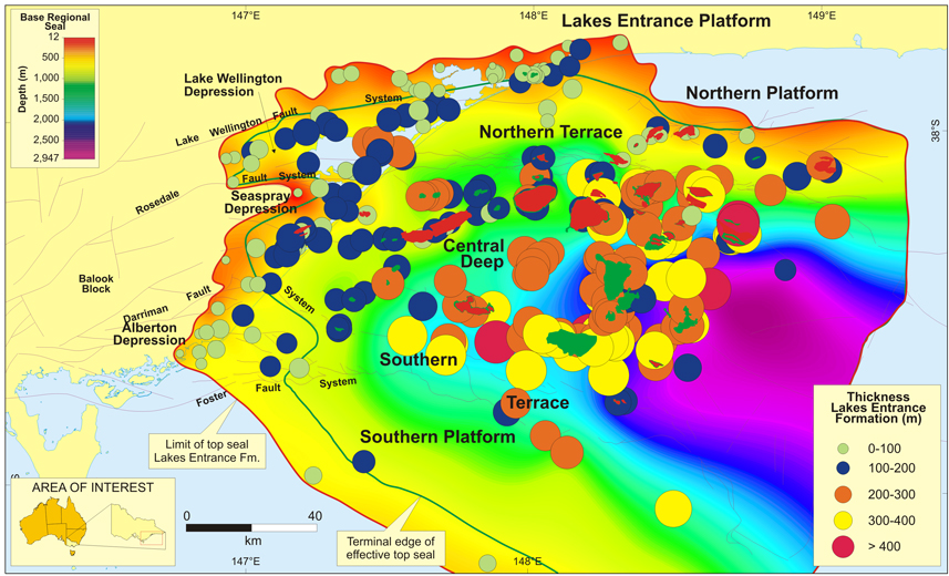
The geometry of the top ![]() seal
seal![]() is consistent with deposition in an early post-rift setting where marine sediments have filled paleo-topographic lows. The
is consistent with deposition in an early post-rift setting where marine sediments have filled paleo-topographic lows. The ![]() thickness
thickness![]() and depth to base of the
and depth to base of the ![]() seal
seal![]() are greatest in the offshore central basin and decrease toward the margins. There is a strong positive relationship between
are greatest in the offshore central basin and decrease toward the margins. There is a strong positive relationship between ![]() seal
seal![]() capacity column heights, the
capacity column heights, the ![]() thickness
thickness![]() of the regional
of the regional ![]() seal
seal![]() and the depth to the base of the
and the depth to the base of the ![]() seal
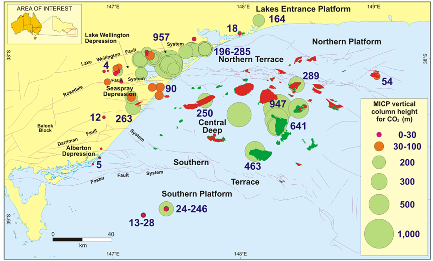
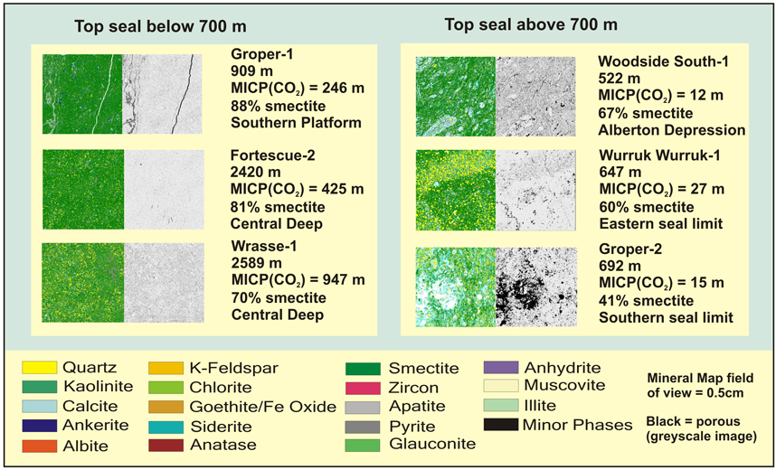
seal![]() . The mineralogical analysis of the top
. The mineralogical analysis of the top ![]() seal
seal![]() has revealed that the Lakes Entrance Formation is principally a smectitic claystone. At greater burial depths and where smectite content is greater than 80%,
has revealed that the Lakes Entrance Formation is principally a smectitic claystone. At greater burial depths and where smectite content is greater than 80%, ![]() seal
seal![]() capacity is increased. In the onshore areas at shallow depths of less than about 700 m, diagenesis of seals subsequent to uplift and freshwater flushing has substantially degraded
capacity is increased. In the onshore areas at shallow depths of less than about 700 m, diagenesis of seals subsequent to uplift and freshwater flushing has substantially degraded ![]() seal
seal![]() capacities.
capacities.
This study has provided the framework for quantitatively evaluating ![]() seal
seal![]() potential at a basin-scale. It has shown that large areas of the basin have very high containment potential, although towards the northern and southern flanks and along primary migration fairways, containment does decrease to unacceptably low levels. Consequently, the integration of our containment investigation with carbon dioxide migration modeling studies will provide the fundamental basis for the development of sequestration projects in the Gippsland Basin.
potential at a basin-scale. It has shown that large areas of the basin have very high containment potential, although towards the northern and southern flanks and along primary migration fairways, containment does decrease to unacceptably low levels. Consequently, the integration of our containment investigation with carbon dioxide migration modeling studies will provide the fundamental basis for the development of sequestration projects in the Gippsland Basin.
|
|
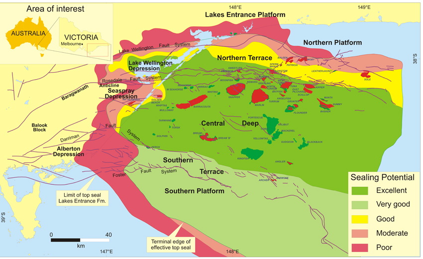
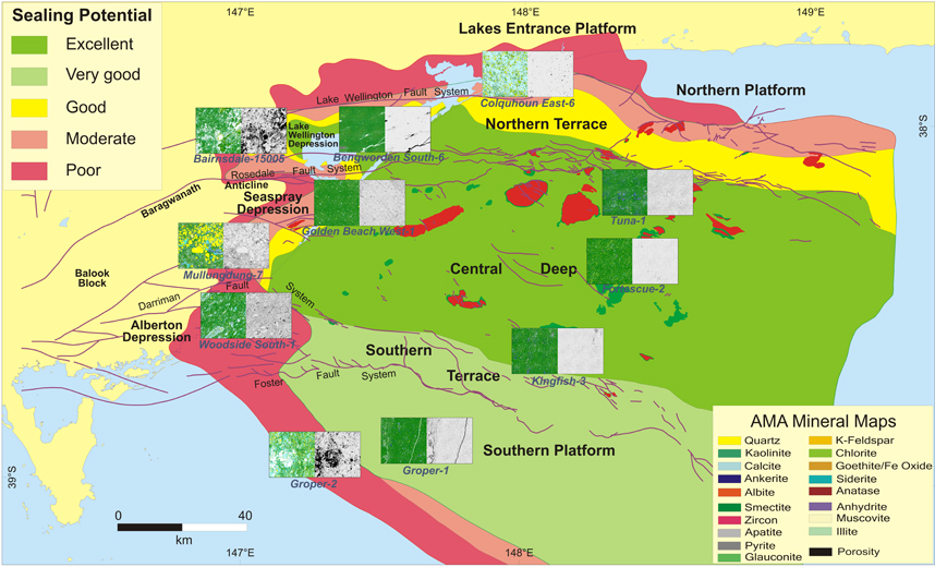
The Gippsland Basin is one of Australia’s most prolific hydrocarbon basins and is located about 200 km east of the city of Melbourne, Victoria, southeastern Australia. World-class oil and gas fields are located in the offshore Gippsland Basin, whilst extensive brown coal deposits and several coal-fired power stations are located predominantly in the Latrobe Valley (Figure 1). Given the strategic nature of geologic sequestration for the long term use of coal in Victoria, the State Government has funded the Victorian Geological Carbon Storage Initiative (VicGCS) to investigate the geological carbon storage potential of the Gippsland Basin. In addition, five exploration tender areas (Figure 1) have been gazetted in the Gippsland Basin by the Federal Government (three offshore blocks) and the State Government (two onshore blocks). The assessment of CO2 containment is important if geologic sequestration is to be considered in these areas. The Lakes Entrance Formation, a succession of calcareous marine claystones deposited at the base of a thick carbonate succession during the Oligocene, provides the regional top Top The top, base,
The MICP (CO2) top Quantitative Mineralogical Analysis of Seals Quantitative mineral analysis uses integrated back scattered electron microscopy (BSEM) and energy dispersive X-ray analyses to identify mineral groupings. The use of this technique known as AMA (Automated Mineral Analysis; AMMTEC Ltd) has provided new insights into the mineralogy of the regional top Where top An interpretation of top The Lakes Entrance Formation provides the regional The techniques employed in this basin-scale evaluation of the regional top Cooperative Research Centre for Greenhouse Gas Technologies, RPT05-0035, 85 p. Goldie Divko, L.M., M.J. Campi, P.R. Tingate, G.W. O’Brien, and M.L. Harrison, 2009, Geological Carbon Storage Potential of the Onshore Gippsland Basin, Victoria, Australia, VicGCS Report 2, Department of Primary Industries, 75 p. Kaldi, J.G. and C.D. Atkinson, 1997, Evaluating Kuttan, K., J.B. Kulla, and R.G. Newman, 1986, Freshwater influx in the Gippsland Basin: Impact on formation evaluation, hydrocarbon volumes and hydrocarbon migration: Australian Petroleum Exploration Association Journal, 26, p. 242-249. O’Brien, G.W., P.R. Tingate, L.M. Goldie Divko, M.L. Harrison, C.J. Boreham, K. Liu, N. Arian, and P. Skladzien, 2008, First Order Sealing and Hydrocarbon Migration Processes, Gippsland Basin, Australia: Implications for CO2 Geosequestration, in J.E. Blevin, B.E. Bradshaw and C. Uruski (editors) Eastern Australasian Basins Symposium III, Petroleum Exploration Society of Australia Special Publication, p. 1-28.
Copyright © AAPG. Serial rights given by author. For all other rights contact author directly. |