![]() Click to view article in PDF
format.
Click to view article in PDF
format.
PSIntegrated Seismic ![]() Structure
Structure![]() , Stratigraphy and
Magnetic Basement Interpretation: Offshore Louisiana Shelf*
, Stratigraphy and
Magnetic Basement Interpretation: Offshore Louisiana Shelf*
Michael Alexander1
Search and Discovery Article #10200 (2009)
Posted August 6, 2009
*Adapted from poster presentation at AAPG International Conference and Exhibition, Cape Town, South Africa, October 26-29, 2008
1Integrated Geophysical Corporation, Houston, TX ([email protected])
This paper presents a rationale for using an integrated interpretation of seismic and magnetic data to reduce risk for a deep play. The methodology has application not only in the Gulf of Mexico (GOM) but also in similar geologic settings.
Basement,
defined here as the magnetic top of crystalline crust, may not correspond
locally to “acoustic” basement identified in some GOM literature as a
mid-Jurassic sequence boundary (MJS). ![]() Depth
Depth![]() differences between basement and
MJS, ranging up to thousands of feet, are significant because they infer the
existence of local pre-MJS troughs with large volumes of nonmagnetic formations
and deep hydrocarbon-generating “kitchens”.
differences between basement and
MJS, ranging up to thousands of feet, are significant because they infer the
existence of local pre-MJS troughs with large volumes of nonmagnetic formations
and deep hydrocarbon-generating “kitchens”.
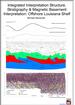
An
example of integrated data is illustrated on a north-south seismic section from
the Louisiana Shelf. It demonstrates a relationship between potential
reservoirs, faults for trapping and/or migration pathways, potential
“kitchens”, and basement ![]() structure
structure![]() . The posted basement and MJS profiles cross
a set of basement ridges, troughs, and faults. A strong reflector, generally
coincident with the MJS depths, is conformable with the basement surface except
over the basement trough. Here the reflector shows north dip and supports
interpretation of an anomalously thick pre-MJS section.
. The posted basement and MJS profiles cross
a set of basement ridges, troughs, and faults. A strong reflector, generally
coincident with the MJS depths, is conformable with the basement surface except
over the basement trough. Here the reflector shows north dip and supports
interpretation of an anomalously thick pre-MJS section.
Reflections
marking the top of Cretaceous-Jurassic (K-J) section are conformable with dips
of the underlying basement. Two complex K-J features overlying a basement
trough, adjacent basement ridges, and a north-verging basement thrust are
deemed attractive targets given their positive ![]() structure
structure![]() , proximity to potential
deep pre-MJS hydrocarbon “kitchens”, and adjacent faults to provide “plumbing”
for favorable hydrocarbon migration. In contrast, both basement and seismic
, proximity to potential
deep pre-MJS hydrocarbon “kitchens”, and adjacent faults to provide “plumbing”
for favorable hydrocarbon migration. In contrast, both basement and seismic
![]() structure
structure![]() to the south show a regional deep from which early-stage hydrocarbons
would have migrated laterally away to more favorable locations.
to the south show a regional deep from which early-stage hydrocarbons
would have migrated laterally away to more favorable locations.
|
An Integrated Approach
A north-south cross-section
traversing part of the offshore Louisiana Shelf has been used to study a
prospective hydrocarbon environment. This example provides a rationale for
using an integrated approach to seismic
An important end-result of this model that fits all data sets is the visual demonstration of relationships between 1) potential reservoirs in seismically-mapped sedimentary structures, 2) their gross stratigraphy, 3) the faults required for trapping and/or providing migration pathways, 4) a potential hydrocarbon “kitchen”, and 5) the magnetic basement.
Magnetic basement
interpretation provides a controlled bottom-up approach to an understanding
of the geologic section and early-stage hydrocarbon migration pathways, or
“initial plumbing”. Magnetic basement is defined here as the top of
crystalline or igneous crust, or less commonly, the top of extremely thick
igneous intrusives/extrusives. It may or may not locally correspond with what
is sometimes termed acoustic, geologic or economic basement. In the
literature pertaining to the U.S. Gulf Coast there are references to an
acoustic “basement” which may be better-defined as a mid-Jurassic sequence
boundary (MJS).
The basement profile for
this 2D model was extracted from a proprietary regional basement surface
interpretation that was based on discrete quantitative magnetic
In addition to the
A prominent set of
high-amplitude reflections (yellow) ranging between 4.0 and 8.0 seconds on
the seismic section can be locally correlated with a horizon variously
described as the MCU, K-T boundary, or top of Cretaceous-Jurassic (K-J)
sediments. The MJS, as estimated from published
The K-T horizon is generally conformable with dips of the underlying magnetic basement time horizon. In contrast, dips in the overlying Cenozoic section appear to be controlled by possible diapiric features and/or by a series of listric, contra-regional, or extensional block faults that do not extend to basement.
In the north half of the profile (Thrust Zone Area), lateral seismic character changes and structurally complex features in the post K-T section overlie a zone of major basement faulting and structuring. Local sedimentary features are associated with a deep basement trough, its adjacent basement ridges, and with the northwest-verging thrusts. A strong energy band (green) generally coincident with time-converted depths extracted from the MJS surface is conformable with the basement surface except over the trough. Here the reflector shows some north dip, thus supporting the concept of an anomalously thick pre-MJS section which could form a deep hydrocarbon “kitchen” with adjacent faults to provide “plumbing” for early-stage migration.
To the south (Transfer
Zone), an abrupt southward thinning of the pre-MJS section and dramatic
expansion of the post K-T/Cenozoic section occurs over an interpreted
regional left-lateral basement transform fault zone intersected by the
profile. There is an evident north-to-south change in seismic character in
the deep Cenozoic. Both the basement
The post-K-T boundary
portion of the model has not been interpreted in detail, other than to post
One of the more important
features of the model is the pre-MJS section overlying magnetic basement.
Previously the MJS
was thought to be not only an acoustic basement but
also a geologic basement.
The coincidence of supra-basement magnetic depths and strong seismic events at MCU/K-T levels suggests that quantitative magnetic interpretation could be used to help bridge seismic interpretation data gaps. It also raises questions as to why the boundary is magnetized and if some level of magnetization is continuous over large areas of the Shelf.
The interpreted non-magnetic pre-MJS is relatively thick and may have a Paleozoic “hydrocarbon kitchen” potential. Structuring and faulting in and above the MJS would control the necessary migration pathways to conduct hydrocarbons to the overlying sediments.
A configuration of the
magnetic basement surface which best fits the pattern of
In summary, integration of
seismic and magnetic interpretations can lower the risk inherent in exploring
deep targets in an offshore shelf environment. Magnetic interpretation can
locate the deep depocenters, high blocks, and major sediment fairways, thus
highlighting the most promising deep hydrocarbon generation, migration, and
accumulation areas. Seismic interpretation can then be concentrated on
detailing the sedimentary
The seismic section displayed is part of a non-exclusive 3D seismic survey provided courtesy of Fairfield Industries, Houston, Texas; its interpretation was made by Integrated Geophysics Corporation. The magnetic basement interpretation was made by Integrated Geophysics Corporation, Houston, Texas, and is based on data from a non-exclusive, high-resolution aeromagnetic survey flown by Fugro Airborne Surveys, Houston, Texas. The gravity profile, provided courtesy of Sidney Schafer Associates, is part of an extensive areal survey.
Bradshaw, E.B. and J.S. Watkins, 1995, Mesozoic and Cenozoic salt migration pathways in offshore Texas, northwestern Gulf of Mexico, GCSSEPM Foundation, Annual Research Conference, Dec. 3-6, 1995.
Culotta, R., et al, 1992,
Deep
Rosenthal, D.B., and R.T.
Buffler, 1987,
|