u Abstract
u Figures
u Nikanassin
u Reservoir
u Production
u Multi-formations
u Production
u Triassic
u Reservoir
u Production
u Conclusions
u Reference
u Abstract
u Figures
u Nikanassin
u Reservoir
u Production
u Multi-formations
u Production
u Triassic
u Reservoir
u Production
u Conclusions
u Reference
u Abstract
u Figures
u Nikanassin
u Reservoir
u Production
u Multi-formations
u Production
u Triassic
u Reservoir
u Production
u Conclusions
u Reference
u Abstract
u Figures
u Nikanassin
u Reservoir
u Production
u Multi-formations
u Production
u Triassic
u Reservoir
u Production
u Conclusions
u Reference
u Abstract
u Figures
u Nikanassin
u Reservoir
u Production
u Multi-formations
u Production
u Triassic
u Reservoir
u Production
u Conclusions
u Reference
u Abstract
u Figures
u Nikanassin
u Reservoir
u Production
u Multi-formations
u Production
u Triassic
u Reservoir
u Production
u Conclusions
u Reference
|
Figure Captions
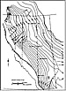
| Figure 1. Precambrian structure map (data from Geological Society of Canada map 1251A) (from Masters, 1984).
|

| Figure 2. Diagrammatic cross section across Central Alberta (from Masters, 1984).
|

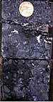
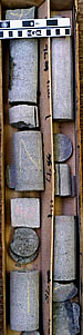
| Figure 3. Extensively fractured fine-grained sandstone, Nikanassin Formation, North Grizzly field. Note partly rubbled core and isolated healed fractures.
|

| Figure 4. Fractured medium-grained sandstone, Nikanassin Formation, North Grizzly field. Two generations of fractures are present, each largely healed by silica and ferroan dolomite cements.
|
| Figure 5. Poorly-sorted fluvial conglomerate, Cadomin Formation, Wild River field. Clay and carbonate cements partly fill interpebble porosity.
|
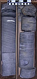
| Figure 6. Large-scale, low-angle cross-bedded fluvial sandstone, lower Gething Formation, Wild River area.
|
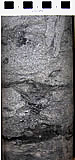
| Figure 7. Burrowed shoreface sandstone, Bluesky Formation, Wild River area.
|
| Figure 8. Massive lithic fluvial sandstone, upper Spirit River valley fill, Wild River area.
|
Nikanassin Structural Play
Nikanassin strata (Figure 2) comprise a thick (in places >1000 meters), easterly-thinning wedge of clastics, deposited as the Jurassic Fernie Sea retreated northward from the WCSB, in response to eustatic sea level fall and immense volumes of sediment
being shed from the rising Columbian Orogen to the west. Blocky to
fining-upward sandstone bodies are interbedded with siltstones, shales,
and minor coal. Net sandstone / gross thickness ratios may exceed
50%, so that more than 500 meters of clean sandstone are found in
some areas. Deposition took place in marginal marine to continental
settings, resulting in an absence of regional stratigraphic markers
and mappable depositional trends. Burial depths range from 1000 meters
in the Peace River Plains, up to 3500-4000 meters in the deep Foothills.
The Nikanassin has been tested throughout the basin, but is productive only where it is extensively fractured by deformation associated with thrust faulting in the outer Foothills.
Reservoir Characteristics
Reservoir sandstones consist primarily of fine- to medium-grained
siliceous litharenites, deposited as channelized bodies on
the order of 5 to 15 meters thick, although individual channels
may stack into thicker bodies. Regional shoreline or valley-fill
trends, where reservoir sandstones would preferentially occur,
have not been mapped. Reservoir quality is very poor. In hand
section, sandstones are glassy and brittle, and break across
sand grains, indicating strong and pervasive cementation. Petrographically,
they are poorly sorted, highly compacted litharenites, composed
primarily of quartz, chert, and sedimentary rock fragments,
cemented tightly with silica. Pores are generally small and
isolated -- most primary porosity has been destroyed, and little
solution porosity has developed. Conventional core analysis
porosity values are generally up to 6%, while permeabilities
are 0.1 md or less. Where the Nikanassin is productive, however,
core and thin-sections show extensive fracturing (Figures 3
and 4).
Tight  Gas Gas Production Production
Several companies are developing Nikanassin tight gas pools
along structural trends in the outer Foothills of northeastern
British Columbia and adjacent Alberta. Wells are drilled along
northwest-southeast fairways, parallel to the leading edges
of thrust faults. Thrust repeats of Cretaceous and Upper Jurassic
strata have been identified in several wellbores, but high-quality
seismic is required to optimize locations where thrust-associated
deformation has fractured the Nikanassin sufficiently to impart
economic permeability. Wells drilled off thrust fronts are
generally non-productive.
Up to five zones within the Nikanassin are typically completed,
and each is fracture-stimulated separately. Many wells have
only recently been put on stream, so it is still early to assess
long-term productive potential. Several of Shell’s wells at
Chinook Ridge have produced up to 90 106m3 (3.2 BCF) in less
than two years, although some of these include contributions
from commingled uphole zones. Many wells to the northwest at
Hiding Creek show lower initial productivities, although production
from uphole zones in this area is more often segregated in
separate wellbores. The ultimate prize in this play is represented
by one of the original wells at North Grizzly, which has produced
577 106m3 (20.4 BCF) since 1979.
Nikanassin reservoirs and thrust deformation can be mapped
northwest and southeast of the current production area, giving
this play considerable upside as seismic control and facilities
expand.
Cretaceous Multi-Formation Commingled Play
Numerous Cretaceous reservoirs are productive in the Deep
Basin (basin-centered gas area) of west-central Alberta and
northeastern British Columbia. Until recently, exploration
has been limited to the pursuit of prolific, high-permeability
stratigraphic “sweet spots”, many of them areally-limited conglomeratic
shoreline facies. With advances in drilling and completion
technology, operators are now developing strategies to access
far larger gas volumes, by commingling production from stacked
Cretaceous tight-gas sandstones.
The Cretaceous commingled play has been developed most intensively
at Wild River, where almost every section in a four-township
area has been downspaced to 2-4 (and in some cases 6) wells
per section. The play area has expanded rapidly and will ultimately
encompass 100 townships or more (based upon regional mapping
of the main productive zones). By drilling to the Upper Jurassic
Nikanassin Formation, up to ten reservoir intervals are evaluated,
and the best four to five are generally completed. Major producers
include:
- Nikanassin -- shallow marine sandstones subcropping beneath the pre-Cretaceous unconformity
- Cadomin -- fluvial sandstones and conglomerates, occurring as a channelized sheet across the area (Figure
5)
- Gething -- fluvial sandstones, mappable as discrete channel trends, stacked at several stratigraphic levels within
a 100-metre thick continental succession (Figure 6)
- Bluesky -- marine shoreface sandstones, occurring in a relatively homogeneous sheet (Figure 7)
- Lower Spirit River -- nearshore facies capping progradational successions, locally exhibiting economic reservoir quality
- Upper Spirit River -- intricate valley fill network, incised during a mid-Cretaceous sea level fall and filled with massive, low-quality lithic sandstones(Figure 8)
- Viking -- marine shoreface sandstones, in relatively distal and low-grade reservoir facies
- Dunvegan -- southern fringe of multicyclic fluvial / deltaic system; completed in only a few wells
- Cardium -- shoreface sandstone unit following a regional northwest-southeast trend. These sands are stand-alone producers to the southeast where fractured along thrust fault trends but are commingled at Wild River, where fracturing is less extensively developed.
Tight Gas Production
Only a few operators, such as Duvernay Oil, Canadian Natural,
and Open Range Energy have established a significant presence
in the Cretaceous commingled play at Wild River. While the
activities of each of these operators is guided by strong geological
mapping, careful attention to costs, and infrastructure access
is required to achieve economic success.
Duvernay has drilled more than 220 wells on the Cretaceous
commingled play to date, and has identified up to 1380 potential
locations on their land base around Wild River (Duvernay corporate
presentation, February 2008). They have established average
reserves of 2.7 BCF / well, and first-year average production
rates of 1.6 MMCF/D, although the best wells exhibit initial
production rates of 5 to 10 MMCF/D. In 2006, Duvernay completed
5 zones per well, then increased to 7 zones per well in 2007.
Open Range, operating in an area with somewhat less stacked
potential, has still placed 57 pay zones on production in 19
wells (3 zones per well) (Open Range corporate presentation,
November 2007).
Systematic cost improvements have been achieved in the past
year with the construction of new infrastructure, and the implementation
of regulatory changes, requiring less testing of individual
zones. The impact of gas royalty changes proposed by the Alberta
government, scheduled to take effect in 2009, has cast some
uncertainty of the future viability of the Cretaceous commingled
tight gas play (and other gas resource plays in Alberta).
Triassic Siltstone Play - Montney Formation
Montney strata accumulated on a broad continental ramp on
the western flank of the North American craton during Early
Triassic time. Aeolian processes supplied most Montney sediment,
which is predominantly siltstone to very fine-grained sandstone,
with little associated mud. Shoreface to subtidal facies in
the east grade westward to basinal facies, cut by turbidite
deposits associated with lowstand events. Good conventional
reservoir quality is found in the shallower, updip portions
of the basin, but westward, reservoir quality decreases in
more distal facies that are buried to depths of up to 3500
meters.
Historically, deep Montney exploration has been focused on
turbidite sandstone fairways in the lower Montney, which retain
moderate reservoir quality into western Alberta and northeastern
British Columbia. Since 2003, an exciting new tight gas play
has emerged in areally-extensive upper Montney distal shoreface
to shelfal siltstones. This play has attained great economic
importance as companies have realized the immense gas resource
available, which can be economically accessed by modern multi-frac
completions in horizontal wells.
Reservoir Characteristics
The upper Montney comprises stacked sections of distal shoreface
to shelf siltstones up to 150 meters thick. Cores show thick,
homogeneous-appearing sections of laminated to massive siltstones.
Although sometimes characterized as a shale gas play, the upper
Montney is primarily siltstone -- the darker laminae in core
commonly contain more organic material and pyrite than mud.
Porosities range from less than 3% up to 10%, although pore
throats are very small, and porosity networks appear poorly
connected, resulting in sub-millidarcy permeability. Operators
generally characterize reservoir in terms of 3% or 6% sandstone
density porosity cutoffs and have reported net pay thicknesses
in excess of 100 meters.
Upper Montney distal shoreface facies are mappable over a
large area of west-central Alberta and adjacent British Columbia.
Several internal log markers highlight major clinoform surfaces
in the overall progradational succession. Variations in cementation,
bioturbation, and organic content can be seen in core across
these markers but have not been systematically mapped on a
regional basis.
Tight Gas Production
Productive potential of the upper Montney was first realized
in 2001, when it was completed uphole in a deep exploratory
well at Dawson in northeastern B.C. ARC Resources developed
the pool using conventional vertical wells, stimulated with
large (up to 100-tonne) fracs. To the south at Swan Lake, EnCana
began a Montney development program in 2005, first using vertical
wells, then moving to horizontal wells, stimulated with several
staged fracs. Initial rates of 4 MMCF/D or greater were reported
in the horizontals, and EnCana moved to a development program
focused entirely on horizontal wells in the upper Montney,
targeting gas-in-place of 25-40 BCF/section. Lower Montney
turbidites are seen as future upside, with gas-in-place of
30-50 BCF/section. ARC adopted the horizontal development strategy
at Dawson, drilling 6 horizontals in 2007, and planning 6 more
in 2008 (ARC corporate presentation, February 2008).
The upper Montney is now one of the hottest gas plays in
Western Canada. It is credited with more than $200 million
in Crown land sales in northeastern British Columbia since
late 2007. A number of large development programs are underway
around the Dawson / Swan Lake core area: to the south at Tupper
(Murphy Oil), to the west at Groundbirch (Duvernay Oil), and
to the east at Pouce Coupe (Birchcliff Energy). Each of the
major players is forecasting multi-TCF in-place resource potential,
and plans multi-year development programs to sustain production
in the 50-100 MMCF/D range or more.
At this early stage of play evolution, regional geology suggests
a huge potentially productive area. Development projects are
radiating from areas of initial discoveries or strategic land
positions and will likely merge into a massive resource play
over the next several years.
Conclusions
Although the WCSB tight gas play spectrum is much different
than that in the U.S. Rockies, huge gains in reserves and productivity
have been attained with improved understanding of the reservoirs,
application of new drilling and completion technologies, and
infrastructure growth.
The
three plays highlighted here - fractured Nikanassin sandstones
in the outer Foothills, stacked commingled Cretaceous targets
in the Alberta Deep Basin, and Montney shoreface siltstones
completed with horizontal, multifrac wells - are only a few
examples of our evolving ability to produce gas economically
from tight reservoirs. In each case, exploitation strategies
have been built upon detailed geological understanding of the
reservoirs.
Reference
Masters, John A., 1984, Lower Cretaceous oil and gas in Western Canada, in Elmworth: Case Study of a Deep Basin Gas Field, John A. Masters, ed.: AAPG Memoir 38, p. 1-33. Field, John A. Masters, ed.: AAPG Memoir 38, p. 1-33.
Return to top.
|