|
uAbstract
uFigures
uEdwards trend
uGeologic setting
uPrevious work
uPNR work
uData set
u2004 concept
uData acquisition
uCurrent ideas
uSub-region features
uNew insights
uClosing remarks
uAcknowledgments
uReferences
uAbstract
uFigures
uEdwards trend
uGeologic setting
uPrevious work
uPNR work
uData set
u2004 concept
uData acquisition
uCurrent ideas
uSub-region features
uNew insights
uClosing remarks
uAcknowledgments
uReferences
uAbstract
uFigures
uEdwards trend
uGeologic setting
uPrevious work
uPNR work
uData set
u2004 concept
uData acquisition
uCurrent ideas
uSub-region features
uNew insights
uClosing remarks
uAcknowledgments
uReferences
uAbstract
uFigures
uEdwards trend
uGeologic setting
uPrevious work
uPNR work
uData set
u2004 concept
uData acquisition
uCurrent ideas
uSub-region features
uNew insights
uClosing remarks
uAcknowledgments
uReferences
uAbstract
uFigures
uEdwards trend
uGeologic setting
uPrevious work
uPNR work
uData set
u2004 concept
uData acquisition
uCurrent ideas
uSub-region features
uNew insights
uClosing remarks
uAcknowledgments
uReferences
uAbstract
uFigures
uEdwards trend
uGeologic setting
uPrevious work
uPNR work
uData set
u2004 concept
uData acquisition
uCurrent ideas
uSub-region features
uNew insights
uClosing remarks
uAcknowledgments
uReferences
uAbstract
uFigures
uEdwards trend
uGeologic setting
uPrevious work
uPNR work
uData set
u2004 concept
uData acquisition
uCurrent ideas
uSub-region features
uNew insights
uClosing remarks
uAcknowledgments
uReferences
|
Selected Figures
|
 |
Map of the Edwards (Stuart City) shelf margin trend. |
|
 |
Stratigraphic diagram, showing general stratigraphy and position of Stuart City trend. |
|
 |
Mid-late Albian paleogeography (from Kerans, 2002). |
|
 |
Depositional model of Bebout and Loucks (1974). |
|
 |
Depositional model of Scott (1990). |
|
 |
Well-location maps (1985 and 2005) of Pawnee (Edwards reef) field, Bee and Live Oak counties, Texas, with plot of gross production. |
|
 |
Map of Edwards and Sligo shelf edges, showing PNR drilling activity, 2005-2008. |
|
 |
Edwards stratigraphy—two units, based on lithology, petrography, and paleontology and illustrated by core samples and well  log log , which shows the Regional Dense Marker Bed separating the two units. See Waite et al. (2007). , which shows the Regional Dense Marker Bed separating the two units. See Waite et al. (2007). |
|
 |
Cross-sectional diagrams of Edwards A and Edwards B, with modern analog for each. |
|
 |
Regional strike section, Stuart City margin, PNR deep pilot holes. Datum: top Edwards. |
|
 |
Regional strike section, Stuart City margin, PNR deep pilot holes. Datum: base RDMB/top Edwards “B.” |
|
|
Click to view sections in sequence. |
|
 |
Tectonic/structural map of region of study area, showing elements that partition reef trend into three main provinces, which show varying influence of basement and salt. |
|
 |
Map showing the six sub-regions of the Stuart City (Edwards reef) trend. |
|
 |
Map, well log, and core photo representative of sub-region 1 (LaSalle - McMullen counties--Rio Grande Salt Basin). |
|
 |
Map and well log representative of sub-region 5 (Lavaca County—Word Field complex). |
|
 |
Map of 3D seismic coverage along Stuart City margin. |
Edwards (Stuart City) Shelf Margin Trend
- A narrow belt of Lower Cretaceous reef/bank and associated sediments that extends for > 250 miles across south Texas.
- Middle Albian Edwards shelf margin underlain by Barremian-Lower Aptian Sligo shelf margin.
- Dry gas fields in combination traps (discovered in 1960’s); 11,000 - 14,000 ft; up to 350o F; average porosity 5%.
- Horizontal drilling revitalized play in late 1990’s, aided by today’s higher commodity prices.
Geologic Setting during Early Mid-Cretaceous
(see Markello et al., 2008)
- Post-Pangea breakup
- Opening of Tethys seaway
- Large percentage of continental shelves in low (tropical) latitudes
- Greenhouse climate
- Low-amplitude, high-frequency sea-level cycles during long-term rise.
- Significant global anoxic events in Albian, Turonian.
- Rise of the rudist bivalves as main reef builders
Previous Work
Bebout and Loucks (1974)
- First comprehensive description of Stuart City facies
- Based on analysis of >10,000 ft. of core from 20 wells along trend.
- Recognized five major environments:
- shelf lagoon
- shelf margin
- upper shelf slope
- lower shelf slope
- open marine (basin)
- Identified 14 separate depositional facies within the 5 environments.
- Noted cement types, porosity types, and distribution; commented on timing of diagenesis (early cementation).
Shelf margin consists of progradational package of requieniid boundstones and caprinid-algal packstones. Outboard margin is interpreted as “patch reefs” on upper slope. Skeletal grainstones show evidence of brief subaerial exposure.
Scott (1990)
Recognized seven environments (landward to seaward):
- open lagoon, with mollusk-miliolid-orbitolinid wackestone
- shoals in lagoon, consisting of grainstone
- reef flat of rudist-coral packstone
- reef frame, consisting of coral-stromatoporoid boundstone
- proximal forereef slope, with coral-rudist packstone
- distal forereef slope, consisting of bioclast packstone
- forereef basin, with bioturbated mudstone, oncolite wackestone
Work of Pioneer Natural Resources (PNR)
Data Set
Example: Pawnee (Edwards reef) Field, Bee and Live Oak Counties, Texas
- In 1985-- 17 wells (no horizontals)
- 4,000 acres (160–320 acre spacing)
- Producing 8.5 MMCFPD
- In 2005-- 80 wells (63 horizontals)
- 5,500 acres (80-acre spacing)
- 3-D seismic coverage
- Producing 50 MMCFPD
PNR’s Incorrect Concept circa 2004
- Edwards viewed as a continuous trend.
- Considered more of a “resource” type play.
- Pawnee was main analog / laboratory: “the whole trend looks just like Pawnee.”
PNR Edwards Trend Data Acquisition (2005 – 2008)
- 10,000 line-miles of previously acquired 2D seismic
- Greater than 300,000 acres under lease
- 85 (and counting) deep pilot holes with full log suites
- 7 new extensive conventional cores
- 1000 mi2 of new 3D seismic (full fold across margin)
- Several new gas discoveries, one significant (Moray Field)
- Numerous production and engineering data (porosity/permeability, capillary pressure, production rates, decline rates, pressure, etc.)
Current Ideas
- Two reefs: Edwards ‘B’ vs. Edwards ‘A.’
- Edwards trend is not a “simple ribbon,” nor is it a true resource play.
- Structure, facies, and diagenesis are all important.
- Salt distribution, deep Jurassic / basement faults, and Sligo margin: fundamental control on development of Edwards reef.
- Very complex system -- “One model” does not fit all.
Features of two examples from six sub-regions
1. LaSalle - McMullen counties (Rio Grande Salt Basin)
- Center of the Rio Grande Salt basin.
- Edwards relatively shallow (10 – 12, 000 ft).
- Sligo margin is far outboard of Edwards margin.
- Pay section restricted to upper portion of Edwards ‘A’ ( +/- 100 ft of total gas column).
- Small bioherms with grainstone/packstone cycles.
- High porosity and permeability (interparticle, vuggy).
- Best wells on salt-related structural highs; depletion concerns in existing fields.
5. Lavaca County (Word Field complex)
- Edwards relatively deep (13,500 – 14,100 ft).
- Edwards margin outboard of Sligo margin.
- Thick Edwards ‘A’ landward of main shelf edge fault.
- Island/tidal flat cycles (Word) and associated low-energy, open marine muddy carbonates; highest porosity-permeability in microporous mudstones.
- Thick gas columns in Edwards ‘A’ (maximum at Word)
- Outboard, massive Edwards ‘B’ reef is mostly wet.
Summary of New Insights
- Shelf margin reef is subdivided vertically into two portions:
- Lower Edwards (‘B’): high relief, barrier-type reef margin
- Upper Edwards (‘A’): low relief bioherms
- Geology of Edwards shelf margin controlled in part by basement configuration and salt distribution:
- Rio Grande Salt Basin / Maverick Basin
- San Marcos Arch
- Houston / East Texas Salt Basin
- More than one geologic model is required to fully characterize the complexities of the reef margin along strike.
Closing Remarks
- Deep Edwards gas play is challenging.
- Conventional play with resource play elements.
- Significant new gas discovery in NW Dewitt County.
- Moving forward: 3D seismic, control costs.
- One eye on the microscope; the other on commodity prices.
Acknowledgments
- Dr. Robert W. Scott, Precision Stratigraphy and University of Tulsa, Tulsa, OK
- Mr. Walter Bloxsom, Consultant, Houston, TX
- Dr. Charles Kerans, University of Texas at Austin, Austin, TX
- Management of Pioneer Natural Resources, Irving, Texas, and and fellow co-workers, South Texas Asset Team
References
Bebout, D.G. and R.G. Loucks, 1974, Stuart City trend, Lower Cretaceous, south Texas: University of Texas at Austin, Bureau of Economic Geology, Report of Investigations 78.
Dravis, J.J., 1991, Carbonate petrography – update on new techniques and applications : Journal Sedimentary Research, v. 61, p. 626-628. : Journal Sedimentary Research, v. 61, p. 626-628.
Kauffman, E.G., and N.F. Sohl, 1974, Structure and evolution of Antillean Cretaceous rudist frameworks: Verhandl. Naturf. Ges. Basel, v. 84, no. 1, p. 399-467.
Kerans, Charles, 2002, Styles of rudist buildup development along the northern margin of the Maverick Basin, Pecos River Canyon, southwest Texas: GCAGC Transactions, v. 52, p. 501-516.
Markello, J.R., R.B. Koepnick, L.E. Waite, and J.F. Collins, 2008, The carbonate analogs through time (CATT) hypothesis and the global atlas of carbonate fields – a systematic and predictive look at Phanerozoic carbonate systems: SEPM Special Publication 89, p. 15-45.
Scott, R.W., 1990, Models and stratigraphy of mid-Cretaceous reef communities, Gulf of Mexico: SEPM Concepts in Sedimentology and Paleontology, v. 2, p. 1-102.
Waite, L.E., R.W. Scott, and C. Kerans, 2007, Middle Albian age of the Regional Dense Marker bed of the Edwards Group, Pawnee Field, south-central Texas: GCAGS Transactions, v. 57, p. 759-774.
Return to top.
Copyright © AAPG. Serial rights given by author. For all other rights contact author directly.
|
 Click to view presentation in PDF format.
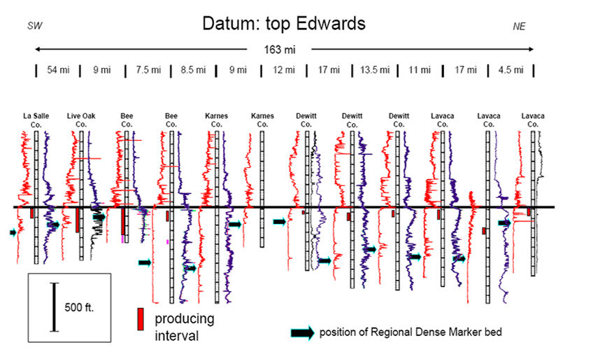