 Click to view article in PDF format (2.5 mb).
Analysis and interpretation of environment sequence models in
Hassi R’Mel Field in Algeria*
R. Baouche1, A. Nedjari2, and R. Chaouchi3
Search and Discovery Article #50188 (2009)
Posted May 15, 20099
*Revised from manuscript prepared for presentation at 2008 AAPG International Conference and Exhibition, Cape Town, South Africa, October 26-29, 2008.
1Laboratory of the Physical Earth, University of Boumerdes, Boumerdes, Algeria ([email protected])
2University of Sciences and Technology–Sedimentary Basins–FTSGAT, Algiers ([email protected])
3Laboratory of Geology of the Sedimentary Basins, University of Boumerdes, Boumerdes, Algeria ([email protected])
With a surface area of 400,000 km2, the Triassic Province in Algeria represents a vast Saharan territory in which significant hydrocarbon layers are exploited at the Triassic and Cambrian–Ordovician levels. The Saharan Triassic consists of sediments of varied continental environments; namely, fluvial, floodplain, lake, sebkha, and wind. At the top of Formation I, the lower series of the Triassic, there are intercalations of volcanic rocks represented by dolerites. Sedimentation interspersed with periods of nondeposition is thought to have occurred during the period of the development of the Triassic continental; resulting in the development of more or less intense pedogenesis, along with associated sediments. These episodes of pedogenesis, significantly influenced by climate, are the source of important discontinuities, which can be used for sequential subdivision.
Formation II is characterized by the eruptive units at the base of the lower member IIa and they consist primarily of dolerites. The top of that unit is defined primarily by a channel in a fine sandy fill. Member IIb is characterized by fluvial facies of channels, changing upward into a complex of playas or evaporites. This complex is characterized, in comparison of neutron/density curves, by a negative polarity at the bottom, with a broad separation of the curves. Formation III is characterized primarily by an evaporite facies, of sebkha-type halite, with weak gamma ray (lower than 10 API). The sonic value is relatively constant--around 70 µs/ft. The various expressions of pedogenesis have been well documented; they include marmorization slits of desiccation features, root traces, polyhedron structures (slickenslides), ferruginizations, and Liesegang rings. In the Saharan Triassic there are also expressions of silcrete, gypscrete, dolocrete, and calcrete. The suggested models of electrosequences are varied at Hassi R’Mel, with several models representing sequences-second, third, and fourth order. The models recognized in wells at Hassi R’Mel field are representative primarily of units filled with siliciclastic, eruptive sediments, and evaporite-type saliferous shale deposits. The top of stratigraphic sequences is represented by discontinuities, modifications related to pedogenesis and not characterized in the old models. This work therefore attempts to refine the above models by using a well-log-based modeling approach (gamma ray, neutron, sonic, density, and resistivity) to examine the evolution of successions, along with facies analysis in Hassi R’Mel field.
|
|
The Triassic formations of Hassi R’Mel field In Algeria have been the subject of several studies (Nedjari et al., 2002) including facies and sequential analysis. Using well log analysis, this study aims to characterize, as a first step, the succession of the various facies of the Triassic formations to help clarify the environments under which the various deposits formed. Applying the results obtained from facies and well log analysis resulted in the definition of eight facies in the formations at Hassi R’Mel: (1) sandstone (sand), (2) shale sand (shaly sand, (3) sand shale (sandy shale), (4) low shale sand (slightly shaly sand), (5) low shale sand dolomite (slightly shaly, sandy dolomite), (6) shale dolomite (shaly dolomite), (7) shale sand dolomite (shaly, sandy dolomite), and (8) dolerite, along with the overlying halite / shale halite (shaly halite). Triassic Succession Studies carried out at FSTGAT (Laboratory of Geodynamics of the Sedimentary Basins, USTHB) showed that the sedimentation is complex (Aît Ouali R. et al., 1996), arising from varied continental environments: alluvial fan, evaporites, fluvial system, and playa. Each environment can be characterized (Miall, A.D., 2002) as follows by a standard succession: fluvial, floodplain, lake, wind and evaporites. Interpreting the well log data also allowed us to evaluate the petrophysical parameters as porosity, permeability and shaliness of the Triassic layers in the Hassi R’Mel gas field. This technique requires highly sophisticated algorithms, giving results of hydrocarbon fluid content for a possible analysis of gas production.
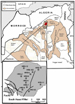
Description of the Hassi R’Mel Area The Hassi R’Mel field is located in Algeria, between 33°15 and 33°45 North, 2°55 and 3°0 East, approximately 50 km south of Laghouat (Figure 1). Elevation is of about 760 m, and the field extends 80 km north–south and 60 km east–west (Figure 2; Magloire, 1970; Courel L. et al., 2000). The gas discovery with condensate in well Hrs-1 (Hamel., 1988), the excellent quality products, and apparent continuity of reservoir contributed to exploration in the general area; other wells were drilled north of the field (Bordj Nili; NL1 with NL5). There sandstone reservoirs preserve their good characteristics but are structurally lower; therefore they were dry or “wet.” Toward the northeast, Lg1, Ph1, and Pg1 revealed a deterioration of the quality of the reservoir. It is the same in the south in Af wells. Examination of the seismic profiles was undertaken with the objective of a stratigraphic seismic study, but unfortunately the profiles available are not adapted for such a study, the seismic not having sufficient resolution, with only the key markers readily distinguishable, and the thick layer of salt overlying the Triassic formations attenuates the seismic signals significantly. Gas condensate is the main product; only those wells drilled east of the Hassi R’Mel structure found oil (Boudjema, A., 1987). This oil was discovered in 1956 by S.N. Repal, but oil development began only in 1970.
Wells and Well Log Data Wells of South Hassi R’Mel used in this study are: Hrs-2, Hrs-4, Hrs-7, Hrs-8, Hrs-9, Hr-6b, Hr-8, Hr-10, Hr-11, Hr-12, and Hr-162. All wells were the subject of correlations, with emphasis on the pedogenetic products (paleosols) as defined by the University of FTSGAT (Aît Ouali R. et al., 1996). Information utilized is: a) Reports/ratios of the layers: work completed by the geologists of Sonatrach in connection with well data. b) Other sources of information such as the that collected from the available bibliographies (Zeggane F., Chikhi Z., USTHB, 2000). c) The database includes the reports and analysis of Sonatrach and the Center of Research and development (CRD) and the results of the student theses at the FTSGAT of Bab Ezzouar (USTHB), synthesis (Broquet P., Hamel A., 1991), and the publications of Nedjari and Aît Ouali in the Triassic province, as well as the results of the work in the area of Zarzaîtine (Hamouche B., 2006). Wireline logs recorded in each of the above wells are: Cement bond log, Density Log, and Bore Hole compensated Sonic, Casing collar Locater, Litho–Density Tool, Compensated Neutron Log, Laterolog, Gamma Ray, and corrected Gamma Ray.
Analysis and interpretation of environment sequence models in these continental deposits are based on analysis of well log and core data. The first stage, based on one-dimensional (vertical) information, consists of:
The second stage, aimed at establishing correlations between the various vertical sections established in stage one includes:
Well-log analysis and core analysis are used to define “electrofacies” and depositional environments. It is essential to use complete sets of log data to identify and correlate formations, especially in continental environments. For example, sandstones containing large amounts of radioactive minerals (potash feldspar, heavy minerals, etc.) may produce high gamma-ray values similar to those obtained from clays. Consequently, the use of gamma-ray and sonic logs alone may give rise to misinterpretations.
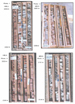
Facies and Core Analysis In South Hassi R’Mel, alternating fine-to-coarse continental terrigenous facies with some interbedded dolomites were observed (Figure 3). Eight main facies are described: one clay facies, three sandstone facies, three dolomite facies, and dolerite (Table 1). In well Hrs-9, interval 2282 to 2286m shows (Figure 3): a) Clean sandstones and argillaceous sandstones at the base. b) Argillaceous matrix, absence of major silicification. c) Importance of the sandstones compared to clays in the series T1 – T2. The fluvial series is characterized primarily by the volume of sand they contain and the associated natural resources (e.g., water, oil). d) Red clays (Photo-1 of the Hrs-2 well) in centimetric layers, with decimetric to metric at the top of the sequences; this aspect corresponds to a floodplain. Clay, centimetric, brown red, probably corresponding to periods of evaporation; brown red clays, siltstone-sandstone in decimetre layers, pseudo-brecciated texture, abundant also at the top of the sequences, thus marking periodic draining. e) Salt (saliferous) is present in rather massive layers, of pink colour, with interbeds of clay, grey black, locally dolomitic; characterizing an evaporitic laguna, under hot and even arid climate; Clays with anhydrite, grey black with dark or green grey, injected anhydrite, characterizing sedimentation at the edge of the evaporitic lagoon, where water is almost permanent, but under influence of siliciclastics derived from areas with flat relief (Photo – 3. Figure 3 [Zeggane F and Chikhi Z, USTHB, 2000]).
Characterization of Environments The studies carried out by the students of FSTGAT (USTHB) on the Triassic sequences showed that sedimentation is very complex but made of various continental-type environments, ranging from alluvial fan to sebkha, with some features of a fluvial cone and a playa. Each environment can be characterized by a standard sequence (Nedjari A., 1998) (Figure 4), consisting of the following models: 1. The evaporite sequence, which is characterized by a desert environment and made up of red argillaceous deposits, with nodules of anhydrite and gypsum with many enterolithic structures and "chicken wire." Discontinuity, related to the pedogenesis, is expressed by gypsum crusts and pink sand. 2. The fluvial sequence, which generally consists of sequences of channel deposits, with decimetric to metric thicknesses, of braided streams. 3. The meander sequence, which is characterized by sand toward the base and argillaceous deposits toward the top of the sequence. 4. The sequence of river and lake environments, for which the sediments are generally clays, fine-grained quartzose sand, iron oxide, carbonates, gypsum, and anhydrite; pedogenesis has modified the sequence more or less intensely. 5. The volcanic sequence, which is primarily made up of volcanic rock, such as dolerite or basalt, with some volcaniclastics. 6. The alluvial fan sequence, which is generally represented at the base by conglomeratic deposits, alternating with sandy deposits.
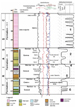
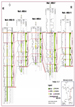
Well Log Responses The combination of the various well log data led to the concept of electrofacies (Serra et al., 1985a; 1985b; 1986; Schlumberger, 1987). The sandy shale series of Hassi R’Mel formations encountered by the wells-Hrs-7, Hrs-9, and Hr-12 could thus be interpreted in the following way: · The deposits of channels show fining-up (bell-shaped signature) or uniform grain size (cylindrical type signature) (Bourquin et al, 1996) (Figure 5). · The deposits of bars within some channel are usually coarsening-up, whereas the saliferous units and/or shale-saliferous units are of the cylindrical type.
Sedimentation at Hassi R’Mel during the Triassic Sedimentation for the Southern Triassic in the area of Hassi R’Mel was continental because of the climate and the structural context. Sedimentation began with fluvial deposition (braid, meander, and floodplain), along with the saliferous deposits under an arid and hot climate. The succession of the various formations was interrupted by episodes of volcanic eruptions during a rifting phase that affected the entire Saharan platform (Nedjari et al., 2002). Several models of sequences (Figure 5) of various scales, have been recognized, in particular second, third, and fourth order. Analysis of the lithofacies and electrofacies, as well as the vertical succession of the stratigraphic units, made it possible to establish the lateral variation of the facies. The development of rather intense pedogenesis resulted in discontinuities of varying importance—but of value in sequence definition (Vail et al., 1977).
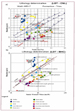
Well-log analysis is used to calibrate electrofacies with sedimentary facies and to infer electrofacies associations and depositional environments directly from well logs. On the density and porosity neutron logs, 0% of neutron porosity (NPhi) corresponds to 2.70 g/cm3 as the rock density (Rhob), with the density curve increasing to the right and the neutron porosity curve increasing to the left. Negative polarity (neutron porosity curve on the right of the density curve), positive polarity (density curve on the right of the neutron porosity curve) and Rhob–Nphi were defined in this way. From the study of well logs (Gamma Ray [GR], Rhob, Nphi, and Sonic [sonic porosity—DT], as well as resistivities, photo-electric factor [Pef], and spectral Gamma [U, TH, and K]) calibrated by cores, three electrofacies are defined as characterizing the main sedimentary facies of Hassi R’Mel sandstones (Figure 6). The facies analysis out of matrix complexes (according to Augier, 1980; Tightened, 1988ä; Bourquin, 1990, 1991, 1993) can be carried out in two stages. The first consists of the establishment of a lithological column starting from one or more reference wells (where all the facies are present). The second stage consists of the use of suitable software for an automatic semi-treatment (PETROLOG, 2002). In the case of this study, the objective is to specify the nature of the environments of deposits (Tightened, 1985b, 1986; Bourquin, 1998) as well as the geometry of the sand bodies. The interpretation of spacing (Rhob-Nphi) between the two curves leads us to introduce the concept of polarity of electrofacies, which one can distinguish as follows: · Electrofacies with positive polarity, where the density (Rhob) curve is on the right of the neutron (Nphi) curve, can indicate the presence of clay, anhydrite, or dolomite. The type of lithology is then distinguished by the values from the density (Rhob), Pef, and GR. · Electrofacies has negative polarity, where the density (Rhob) curve is to the left of the neutron (Nphi) curve, indicating the presence of sandy facies, gas, or halite. · The third electrofacies has a neutral polarity, where the density (Rhob) curve overlies the neutron (Nphi) curve, indicating sandy facies.
Analysis of the signatures of a score of wells in the Hassi R’Mel field are made it possible to highlight eight electrofacies, which are shown in Table 1.
Analysis of the electro sequences of the wells of Hassi R’Mel showed several interesting findings.
Fluvial system Fluvial bars of channel meanders (Hrs-12) have a negative polarity with a rather broad spacing depending, however, on the content of matrix clay; they are characterized by the following: 13<GR<45 (API), 58<DT<8 2 (µs/ft), 2.28<Rhob<2.60 (g/cc) (2, Figure 5). The sandy bars of the type found in the braid are present primarily in Formation II (Hrs-7) (2, 3, Figure 5), which is generally sandy with intercalation of thin beds of clay. The sandy units show decreasing grain size upward, as well as variations in thickness. Conglomerates and erosional contacts are present at the base of the formation. They have a negative polarity, with a large spacing. Representative values are: 37<GR<91 (API), 64<DT<92 (µs/ft), 0.06<Nphi<12; resistivities varying from 2 to 8 ohm/m.
In the floodplain, sedimentation is represented primarily by clays. Traces of roots as well as desiccation elements, along with slickenslides, marmorizations, nodules, and local carbonate crusts, reflect pedogenesis (Figure 6). These are related to variations of the phreatic zone. They have a negative polarity, with a large spacing. Representative values are: 92<GR<133 (API), 66<DT<100 (µs/ft), 0.18<Nphi<36; resistivity varying from 2 to 33 ohm/m.
Lacustrine Environments Lake environments are characteristic primarily on the level of the wells ( 4, Figure 5. They have a negative polarity, with a great spacing neutron/density that is connected to the matrix clay fraction and whose well log responses are characterized by the following: 36<GR<117 (API), 70<DT<100 (µs/ft), 0.12<Nphi<0.23; resistivity varying from 1 to 3.5 ohm/m.
Environments of Evaporites (Sebkha) Sebkha facies correspond to evaporites of the coastal plain and are halite, according to cross-plot of neutron vs density (1, Figure 5). The sequences observed reflect marine brine incursions and then evaporation (Bourquin et al., 1996). There appears to be a clay–salt–clay succession. These units are dated Rhaetian and they are widespread. The halite beds exhibit a negative polarity, with a great spacing neutron/density. Representative values are: 5<GR<50 (API), 68<Dt<84 (µs/ft), –0.009<Nphi<0.06a; resistivities are greater than 6000 ohm/m.
Wind deposits or wind-blown particles are not easily detectable by the well log data. However, an example is thought to be present in the Hrs-4 well (Figure 8, core no. 4; depth, 2156 m).
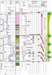
Results and Analysis One can identify the dolerite associated with paleosols at the base of Formation II; this is representative of the major discontinuity with the top of Formation I. Shown in Figure 9 are: · Significant thickness variations; at Hrs-4 well the structure could be a horst. · Formation I has considerable shale in Hrs-10; yet this unit probably has good reservoirs qualities. · The thickness of the evaporite series decreases from Hrs-10 toward Hrs-4 but increases toward the Hrs-11 well.
In well HRS-7 the following are present (Figure 8) (Zeggane F., Chikhi Z., USTHB, 2000): · Red marmorization rusts at 2200m; · Gypscrete at 2158 m; · Desiccation feature filled with crystalline quartz at 2151.5 m; · Argilane at the coast at 2144.5 m; · Burst quartz at 2153 m; · Pedogenetic nodules at 2150 and 2158 m; · Brecciation at 2157.5 m; and · Dolerite at 2157.5 m.
Detailed analysis of the well log responses shows that the paleosol intervals have particular well log characteristics that enable us to identify them in non-cored wells. These well log characteristics are as follows: Radioactivity GR, varying from 30 to 116 (API); resistivity (Rt), very weak and varying from 1.0 to 10 ohm/m; bulk density (Rhob), varying from 2.34 to 2.67 G/DC; neutron porosity (Phin), varying from 12% to 32%; sonic (DT), varying from 74 to 92 (µs/ft).Applying these results to the other wells, such as Hrs-2, Hrs-4, Hrs-7, Hrs-9, Hrs-12, and Hrs-162, made it possible to detect the positions of paleosols starting from the well log and making sequential correlations in formations I, II, and III.. Formation I is characteristic of meander-type fluvial deposit, distal where a fine and argillaceous material dominates. Formation II was formed in a fluvial system that was predominantly braided, and it is represented in all the reservoirs of Hassi R’Mel. These reservoirs are developed in a complex way; yet they present a tabular geometry in layers with wide extent, limited by argillaceous beds (primarily vertical seals) and by Formation III of the shale-saliferous series (S4), which in turn is defined at its top by the reference mark “D2”, which is dated “Lias.” The base of the Triassic is the Hercynian discordance. In Hrs-9, paleosols aid in definition of the formations, respectively with representative values as follows:: Formation III: 24<GR<75; 9<Rt<160; 2.50<Rhob<2.75; 0.30<Phin<0.08; 57<Dt<93. Formation II: 33<GR<95; 0.14<Phin<0.33; 2.33<Rhob<2.60; 70<DT<87. Formation I: 40<GR<80; 4<Rt<13; 2.57<Rhob<2.46; 0.16<Phin<0.20; 75<Dt<86.
The authors would like to thank Professor Ahmed Nedjari for providing the data set used for this research study and correcting this manuscript. We remain grateful to Digital Formation for their software support and to Geosciences Rennes1 for technical advice during the training course studies. Our gratitude goes to Bourquin Sylvie (Sedimentary basins of Geosciences Rennes1) for his assistance during the well-log evaluation. The work reported in this paper was funded by The University of Bab Ezzouar Algiers, Sedimentary basins Research.
Selected Bibliography Augier, C., 1980, Complex well log and matrices. First part: analyze faciologic:Report/ratio interne Elf Aquitaine. Aît Ouali R., and Nedjari A., 1996. The Saharan Triassic province. 20 years of geological information: critical assessment and reflexions: Bulletin of the Geological Service of Algeria, v. 7 (2), p. 211-228. Boudjema, A., 1987, Structural evolution of the oil basin "Triassic" of the Eastern northern Sahara (Algeria): Thesis of doctorate, Univ. Paris-South. Hundred. Orsay, 279 p. Bourquin, S., 1991, Analyze facio-sequential by well log mid-west of the basin of Paris: contributions with the reconstitution of the environment of deposit: Thesis University Nancy I, 215 p. Bourquin, S., Boehm, C., Clermonte, J., Durand, M. and Serra, O., 1993, Faciologic and sequential analysis of Sorted mid-west of the Basin of Paris starting from the well log data: Bulletin of the Geological Company of France, 2. Bull. Soc. Geol. Fr., t. 164, 2, p. 177-188. Bourquin, S., and Guillocheau, F., 1996, Keuper stratigraphic cycles in the Paris Basin and comparison with cycles in other Peritethyan basins (German Basin and the Bresse-Jura Basin). Sedimentary geology, v. 105, p. 159–182. Broquet P., and Hamel A., 1991. Triassic sandstones of the gas layer of Hassi R'Mel (Algeria). Stratigraphic, sedimentological, paleogeographic context and application of thermoluminescence [Triassic sandstone of Hassi R' Mel gas field (Algeria). Stratigraphy, sedimentology, paleogeography and thermoluminescence applications]: Bull. Ploughshare. Géol. Fr., v. 162 (3), p. 563-573. Busch, D.A., 1971, Genetic units in delta prospecting: AAPG Bulletin, v. 55, p. 1137–1154. Courel L., Ait Salem H., Ben Ismail H., El Mostaine M., Fekirine B., Kamoun F., Mami L., Oujidi M., and Soussi M., 2000, An overview of the epicontinental, Triassic series of the Maghreb (NW Africa), in Bachmann, G.H., and Lerche, I., eds.: Epicontinental Triassic: Zbl. Geol. Päont., tome 2, 9-10, p. 1145-1166. Cross, T.A., 1988, Controls on coal distribution in transgressive–regressive cycles, in Wilgus, C.K., Hastings, B.S., Kendall, C.G.St.C., Posamentier, H.W., Ross, C.A., and Van Wagoner, J.C., eds., Sea-level Change: An Integrated Approach. SEPM Spec. Publ. 42, p. 371–380. Cross, T.A., Baker, M.R., Chapin, M.A., Clark, M.S., Gardner, M.H., Hanson, M.S., Lessenger, M.A., Little, L.D., McDonough, K.J., Sonnenfeld, M.D., Valazek, D.W., Williams, M.R., and Witter, D.N., 1993, Applications of high-resolution sequence stratigraphy to reservoir analysis, in Eschard, R., Doligez, B., eds., Subsurface Reservoir Characterization from Outcrop Observations: IFP Exploration and Production Research Conference, Edition Technip, Paris, p. 11–33. Galloway, W.E., 1989, Genetic stratigraphic sequences in basin analysis I: Architecture and genesis of flooding-surface bounded depositional units: AAPG Memoir 73, p. 125–142. Galloway, W.E., 1989, Genetic stratigraphic sequences in basin analysis II: Application to Northwest Gulf of Mexico Cenozoic Basin: AAPG Memoir 73, p. 143–154. Galloway, W.E., 1989a, Clastic facies models, depositional systems, sequences and correlation: A sedimentologist's view of the dimensional and temporal resolution of lithostratigraphy, in Cross, T.A., ed., Quantitative Dynamic Stratigraphy. Prentice Hall, p. 459–477. Galloway, W.E., and Williams, T.A., 1991, Sediment accumulation rates in time and space: Palaeogene genetic stratigraphic sequences of the northwestern Gulf of Mexico Basin: Geology, v. 19, p. 986–989. Hamouche B., 2006, Safeguarding of the fluvial systems of Sorted Algerian: Impact of the climate and the deformation, in 10th French Congress of Sedimentology, October 11-13, 2005, Giens, Delivers summaries, Oral Communication. Géosciences de Rennes1, 2006. Homewood, P., Guillocheau, F., Eschard, R., and Cross, T.A., 1992. Corrélations haute résolution et stratigraphie génétique: une démarche intégrée: Bull. Cent. Rech. Explor.-Prod. Elf-Aquitaine 16, p. 357–381. Jervey, M.T., 1988, Quantitative geological modeling of siliciclastic rock sequences and their seismic expression, in Wilgus, C.K., et al., eds., Sea-level Changes: An Integrated Approach: SEPM Spec. Public. 42, p. 47–70. Magloire, P.R., 1970, Triassic gas field of Hassi er R’Mel, Algeria, in Geology of Petroleum Fields, Halbouty, M.T., ed.: AAPG Memoir 14, p. 489-501. Miall, A.D., 2002, Architecture and sequence stratigraphy of Pleistocene fluvial systems in the Malay Basin based on seismic time slice analysis: AAPG Bulletin, v, 86, p. 1201-1216. Nedjari, A., Ait Ouali R., and Delfaud J., 2002, Sorted basins Saharan and atlassic Algerian: Development and news approaches. [Triassic of the Algerian Atlassic and Saharan basins], in Stratigraphy of Algeria: Contributions and Developments; Csa, S.G.A., ed.: Memoirs of the Geological Service of Algeria, v. 11, p. 87-113. Nedjari A., 1998, Litho sequences and 3° electro sequences in the Carboniferous in one of the basins of Abadla: Comparison of the models and interpretations: Bulletin Geological Service of Algeria, v. 9 (1), p. 69-79. Petrolog, 2002, Advanced Log Analysis Software. v .10: Crocker data processing, Petroleum House. WA 6102, Australia. Serra, O., 1985a, Differed well log, bases interpretation. v.2, Interpretation of the well log data, 7. Bull. Centers rech.Explor.-Prod.Elf-Aquitaine, Mém. Pau, 631 p. Serra, O. 1985b,Sedimentary environment from wireline logs: Schlumberger, 211 p. Serra, O. 1986, Differed well log: Their use in sedimentary geology: Bull. Centers rech. Expl-Prod. Elf Aquitaine, v. 10, p. 205-227. Schlumberger, 1987, Collection of charts of interpretation of the well logs: France (Paris). Schumm, S.A., 1993, River response to base level change: implications for sequence stratigraphy: Journal of Geology, v. 101, p. 279–294. Vail, P.R., Mitchum, R.M., Todd, R.G., Widmier, J.M., Thompson, S.I., Sangree, J.B., Bubb, J.N., and Hatlelid, W.G., 1977, Seismic stratigraphy and global changes of sea-level, in Seismic stratigraphy - applications to hydrocarbon exploration, Payton, E.C., ed., AAPG Memoir 26, p. 49-212. Wheeler, H.E., 1964, Base level, lithosphere surface and time-stratigraphy: GSA Bulletin, v. 75, p. 599–610. Wheeler, H.E., 1964, Base level, transit cycle, in Merriam, D.F., ed., Symposium on Cyclic Sedimentation. Bull. Kansas Geol. Surv. 169 (1), p. 623–630. Wheeler, H.E., and Murray, H.H., 1957. Base level control patterns in cyclothermic sedimentation: AAPG Bulletin, v. 41, p. 1985–2011. Zeggane F., Chikhi Z., USTHB, 2000, Sedimentopedogenetic study of Hassi R' Mel Southern (Western Province) and characterization of the mediums of deposits. Cutting of sequences A, B and C .
|


Copyright © AAPG. Serial rights given by author. For all other rights contact author directly.