Click to
view posters in PDF format.
Click to
view posters in PDF format.
PSWestern
Australia’s ![]() Geothermal
Geothermal![]() Resources*
Resources*
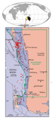
Western Australia commenced a new era in the search
of ![]() energy
energy![]() from
from ![]() geothermal
geothermal![]() resources to broaden State’s
resources to broaden State’s ![]() energy
energy![]() base by the first
acreage release for
base by the first
acreage release for ![]() geothermal
geothermal![]() exploration in the Perth Basin on 22 January 2008
(Figure 1). Coincidently, the first Australian
exploration in the Perth Basin on 22 January 2008
(Figure 1). Coincidently, the first Australian ![]() geothermal
geothermal![]() production well
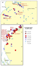
reached its target depth of 4221 m in Geodynamics Habanero 3 (Figure 2). The
production well
reached its target depth of 4221 m in Geodynamics Habanero 3 (Figure 2). The
![]() geothermal
geothermal![]() acreage release followed the amendments to the State’s Petroleum Act
1967 that was proclaimed in January 2008, Petroleum and
acreage release followed the amendments to the State’s Petroleum Act
1967 that was proclaimed in January 2008, Petroleum and ![]() Geothermal
Geothermal![]() Resources Act
1967.
Resources Act
1967.
South Australia was the first State to develop
legislation for ![]() geothermal
geothermal![]() exploration and granted the first Australian
exploration and granted the first Australian
![]() Geothermal
Geothermal![]() Exploration Licence (GEL) in 2001. Since then about 12
Exploration Licence (GEL) in 2001. Since then about 12 ![]() geothermal
geothermal![]() wells have been drilled in South Australia by the following companies:
Geodynamics, Petratherm, Green Rock
wells have been drilled in South Australia by the following companies:
Geodynamics, Petratherm, Green Rock ![]() Energy
Energy![]() , Scopenergy, and
, Scopenergy, and ![]() Geothermal
Geothermal![]() Resources
(Figure 2). There is an increasing trend with exponential increase in interest,
companies, and investment for exploring and developing
Resources
(Figure 2). There is an increasing trend with exponential increase in interest,
companies, and investment for exploring and developing ![]() geothermal
geothermal![]()
![]() energy
energy![]() . The
investment totalling $686 million has been proposed for five-year work program
by 27 companies in 166 licences.
. The
investment totalling $686 million has been proposed for five-year work program
by 27 companies in 166 licences.
The majority of current and forecast investment to
explore for, and demonstrate the potential of, ![]() geothermal
geothermal![]()
![]() energy
energy![]() in Australia
focused on hot rock enhanced
in Australia
focused on hot rock enhanced ![]() geothermal
geothermal![]() systems (EGS). The most promising
Australian basins include: Cooper Basin in the south-west corner of Queensland
and South Australia, the Hunter Valley, New South Wale, and the Perth Basin,
Western Australia.
systems (EGS). The most promising
Australian basins include: Cooper Basin in the south-west corner of Queensland
and South Australia, the Hunter Valley, New South Wale, and the Perth Basin,
Western Australia.
For this century, ![]() energy
energy![]() outlook indicates that
there will be significant
outlook indicates that
there will be significant ![]() energy
energy![]() supply from
supply from ![]() geothermal
geothermal![]() , solar, wind, and hydro
resources. Of these,
, solar, wind, and hydro
resources. Of these, ![]() geothermal
geothermal![]()
![]() energy
energy![]() from hot rocks shows the greatest
potential for long-term, continuous electricity supply and Australia leading way
in EGS technology. The trend in EGS technological advances indicate, within
decades, the cost for electricity generation from EGS will be competitive with
conventional
from hot rocks shows the greatest
potential for long-term, continuous electricity supply and Australia leading way
in EGS technology. The trend in EGS technological advances indicate, within
decades, the cost for electricity generation from EGS will be competitive with
conventional ![]() energy
energy![]() generation from coal and natural gas, and lower than any
other form of renewable
generation from coal and natural gas, and lower than any
other form of renewable ![]() energy
energy![]() (solar, wind, wave, tidal).
(solar, wind, wave, tidal).
|
|
For electricity generation, suitable
temperatures for hot water and steam range from 120 to 370°C. In
contrast, shallower reservoirs of lower temperature (21-149°C) can be
used directly in health spas, greenhouses, fish farms and other
industries, and in space-heating systems for homes, schools, and
offices. Most sedimentary basins have low-temperature
Direct use of low-temperature hydrothermal
resources (~50°C) in Australia include swimming pool heating at
Perth’s Challenge Stadium, Victoria’s spa developments at Mornington
Peninsula and Mataranka, New South Wales’s artesian baths at Moore,
Lighting Ridge, and Pilliga. For heating and cooling, heat source pump
are in use at the Canberra’s Geoscience Australia building, Hobart’s
Integrated
Medium-temperature hydrothermal resources
(50-100°C) are in use in many places in the world, including
Birdsville in Queensland. These hydrothermal resources are in use for
both direct heating and cooling and electricity production, with a
potential to increase the direct use of
Conversion of
Geological, hydrogeological, electrical,
magnetic, geochemical, and seismic data are used to locate potential
Australia is tectonically stable and does
not have geologically active areas characterized by volcanism, crustal
rifting, and recent mountain building that typically host
high-temperature hydrothermal provinces. However, there is potential
for
At present, the only
Australian and Western Australian
First study, specifically to evaluate
The first study by Bestow (1982), mainly
focused on low-temperature
The second study by Chopra and Holgate
(2007) was on high-temperature
The Chopra and Holgate (2007) study has
evaluated the quality and quantity of available subsurface temperature
data from 273 petroleum exploration wells in the Canning (100),
Carnarvon (90), and Perth basins (83), and extracted temperature data
from more than 580 wells yet to be evaluated. The purpose was to
calculate reliable true formation temperatures, to estimate the
equilibrium
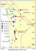
The most prospective basin for Geochemical analyses of basement rocks are required to assess the heat-generation capacity of rocks, as small differences in the concentrations of thorium and uranium can have quite significant impacts on heat-generation capacity, whereas large variations in potassium concentration have only a second order effect on the heat-generation capacity. The stress conditions are best known for the Perth Basin where the predominant orientation of the maximum horizontal stress is east-west, with similar conditions inferred for the Canning and Carnarvon basins. Given that this stress orientation is compatible with both strike-slip and overthrust failure, an understanding of relative stress magnitudes is also required for assessing the uncertainty in the application of EGS technology.
The extent and economic feasibility of
hydrothermal and hot rock
This north-south elongated trough in the
southwest of Western Australia (Figure 1) contains mostly a Permian to
Lower Cretaceous succession under a thin cover of Tertiary. The
eastern boundary is the Darling Fault and the basin extends offshore
to the continental-oceanic boundary. The Perth Basin has been studied
since the early 1900s for geological mapping and evaluation of coal,
water, mineral, and petroleum resources. The published and unpublished
data of these studies are archived in the GSWA Library; they provide
detail background on geology of the Perth Basin. This evaluation, as a
first look, is mainly based on GSWA publications including those on
Figure 6 shows generalised stratigraphy of
the Perth Basin and distribution of water aquifers, petroleum
reservoirs, and potential
The salinity of the groundwater in the
youngest Quaternary-Neogene aquifers ranges from about 130 to 12,000
mg/L TDS (total dissolve solids), temperature at the water table
ranges from 19 to 24oC, averaging about 21oC
(Davidson 1995), and the age of water ranges from present to about
2000 years at the base (Thorpe and Davidson, 1991). Within the
Cretaceous Leederville aquifer, the salinity ranges from 176 to 2511
mg/L TDS, and temperature from 20 to 39oC. The average
Figure 7 shows the distribution of:
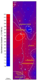
Petroleum wells (242) provide temperature
distribution for a larger area and a greater depth (850 m) than the
Perth region water bores. Of these, 83 wells have been studied by
Chopra and Holgate (2007) for
For the Perth Basin, the estimated
Conceptual models for petroleum and
For the Perth region as a whole, stress data collected in situ are available from 43 locations at different depths and from different sources, but for the Perth Basin portion, the data are exclusively from borehole breakouts recorded in 20 petroleum exploration wells. The recorded maximum horizontal stress orientations are E-W across the Perth region (Reynolds and Hillis, 2000); these observations are highly relevant for assessing the HDR prospectivity of the basin, because maximum horizontal stress is favourable (Chopra and Holgate, 2007).
First acreage release in Western Australia
is the beginning of a major expansion in exploration for hot dry rock
Pre-competitive geoscience information
relevant to hot rock
Bestow,
T.T, 1982, The potential for
Chopra,
P.N, 2005, Status of the
Chopra,
P.N, and F. Holgate, 2005, A GIS analysis of temperature in the
Australian crust: Proceedings, World
Chopra,
P.N, and F. Holgate, 2007,
Cull, J.P,
1977,
Cull, J.P, 1979, Regional variations in Australian heat flow: Australia BMR, Journal of Australian Geology and Geophysics, v. 4, no. 1, p. 1-13.
Cull, J.P, 1982, An appraisal of Australian heat flow data: Australia BMR, Journal of Australian Geology and Geophysics, v. 7, p. 11-21.
Cull, J.
P, and D. Denham, 1978, A case for research and development on
Crostella, A., 1995, An evaluation of the hydrocarbon potential of the onshore Perth Basin: Western Australian Geological Survey, Report 43, 67 p.
Crostella, A., and J. Backhouse, Geology and petroleum exploration of the central and southern Perth Basin, Western Australia: Western Australian Geological Survey, Report 57, 85 p.
Davidson, W.A., 1995, Hydrogeology and groundwater resources of the Perth Region, Western Australia: Western Australia Geological Survey, Bulletin 142, 257p.
Ghori,
K.A.R., 2007, Search for
Ghori,
K.A.R, 2008, The search for Western Australia’s
Hillis, R. R., and S. D. Reynolds, 2000, The Australian Stress Map: Journal of the Geological Society, London, v. 157, p. 915-921.
Mory, A.J., and R.P. Iasky, 1996, Stratigraphy and structure of the onshore northern Perth Basin, Western Australian Geological Survey, Report 436, 102 p.
Narayan,
S.P., D. Naseby, Z. Yang, and S.S. Rahman, 1998a, Petroleum and hot
dry rock: two of the
Narayan,
S.P., D. Naseby, Z. Yang, and S.S. Rahman, 1998b, Creation of HDR
reservoirs under Australian in-situ stress conditions, in
Proceedings of Twenty-third Workshop on
Owad-Jones,
D., and G. Ellis, 2000, Western Australia atlas of petroleum fields,
Onshore Perth Basin: Petroleum Division, Department of Mineral and
Regenauer-Lieb, K., and F. Horowitz, 2007, The Perth Basin
Reinecker, J., O. Heidbach, M. Tingay, B. Sperner, and B. Müller, 2005, The release of the 2005 World Stress Map: World Stress Map Project, Geophysical Institute, Karlsruhe University (http://www.world-stress-map.org).
Sass, J.H, 1964, Heat-flow values from the Precambrian of Western Australia: Journal of Geophysical Research, v. 69, no. 2, p. 299-308.
Sass, J.H., J.C. Jaeger, and R.J. Munroe, 1976, Heat flow and near-surface radioactivity in the Australian continental crust: United States Geological Survey, Open-File Report 76-250, 91p.
Somerville, M., D. Wyborn, P. Chopra, S. Rahman, D. Estrella, and
V.D.M. Theo, 1994, Hot dry rock feasibility study, a report compiled
for the
Thorpe, P.M., and W.A. Davidson, 1991, Groundwater age and hydrodynamics of the confined aquifers, Perth, Western Australia, in Proceedings of the International Conference on Groundwater in Large Sedimentary Basins, Perth, Western Australia, 1990: Australian Water Resources Council Series, no. 20, p. 420-436. |