 Click to view article in PDF format.
GC Imaging Super-Deep Targets with P-P and P-SV Data*
By
Bob Hardage1, Michael DeAngelo1, and Randy Remington1
Search and Discovery Article #40279 (2008)
Posted March 25, 2008
*Adapted from the Geophysical Corner column, prepared by the authors, in AAPG Explorer, February, 2008, and entitled “Going Super-Deep with P-P, P-SV Data.” Editor of Geophysical Corner is Bob A. Hardage. Managing Editor of AAPG Explorer is Vern Stefanic; Larry Nation is Communications Director.
1 Bureau of Economic Geology, The University of Texas at Austin ([email protected])
Hardage et al. (2006) described the value of 4-component ocean-bottom-cable (![]() 4-C
4-C![]() OBC)
OBC) ![]() seismic
seismic![]() technology for acquiring long-offset
technology for acquiring long-offset ![]() seismic
seismic![]() data across congested production areas. Since that story was told, however, there has been increasing interest in acquiring long-offset data along the northern shelf of the Gulf of Mexico (GOM), because operators want to locate super-deep gas prospects beneath the numerous production facilities that are already in place across this offshore trend.
data across congested production areas. Since that story was told, however, there has been increasing interest in acquiring long-offset data along the northern shelf of the Gulf of Mexico (GOM), because operators want to locate super-deep gas prospects beneath the numerous production facilities that are already in place across this offshore trend.
We use the term “super-deep” here to describe drilling targets that are at depths of nine to 10 kilometers (30,000-33,000 feet). To create optimal images of geology at these depths, ![]() seismic
seismic![]() data need to be acquired with source-to-receiver offsets that extend to nine to 10 kilometers.
data need to be acquired with source-to-receiver offsets that extend to nine to 10 kilometers.
Such long-offset data are difficult (impossible?) to record with towed-cable technology, where there are closely spaced production facilities that limit the movement and use of long cables. In contrast, long-offset data are relatively easy to record across congested areas when receivers are stationary on the seafloor, as they are in a ![]() 4-C
4-C![]() OBC deployment.
OBC deployment.
|
|
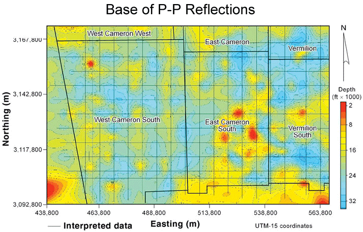
Maximum Depths Imaged by P-P and P-SV Data
We now extend the story that was started in Hardage et al. (2006) to show the maximum depths to which P-P and P-SV modes can image when These interpreted horizons should not be confused with structural horizons because each horizon crosses geologic time lines. The only objective was to define a horizon that marked the depth at which there was a loss of usable reflection signal for the P-P and P-SV modes, without any regard as to where that horizon was positioned in the stratigraphic column. The P-SV data that were interpreted were first time-warped to convert P-SV image time to P-P image time. The interpretation team concluded that across most of the study area, this time warping was reasonably accurate and caused geology shown by the P-SV data to be positioned within ±100 ms of where the same depth window was positioned in P-P image space – a rather good first-order depth registration of P-P and P-SV data.
Once a horizon of deepest usable reflection signal was interpreted along each profile, time-based P-P and P-SV maps of these horizons were made and these maps were then converted to depth maps using
Comparing the maps of Figures 2 and 3 confirms that, in a general sense, P-P and P-SV data image GOM geology to equivalent depths, at least across this particular area. This statement is only a big-picture view of the maps. Locally there are places where there are differences in the depths to which each mode produces continuous reflection events.
The basic message provided by these depth maps is critical information for explorationists operating in the GOM – namely, long-offset
This research was funded by the U.S. Department of Energy; the
Hardage, Bob A., Randy Remington, Michael Deangelo, and Khaled Fouad, 2006, Imaging deep gas targets across congested marine production areas: Search and Discovery article #40190 (2006).
|