Click to view article in PDF format.
The Relationship Between Recovery Efficiency
and Depositional Setting in a ![]() Deltaic
Deltaic![]() Plain Environment*
Plain Environment*
By
Robert C. Shoup1
Search and Discovery Article #40240 (2007)
Posted May 23, 2007
*Adapted from oral presentation at AAPG Annual Convention, Long Beach, California, April 1-4, 2007 and poster presentation at the 2006 AAPG International Conference and Exhibition; November 5-8, 2006; Perth, Australia.
14001 Fannin Street, Houston, Texas 77004 ([email protected])
A Full Field Review was conducted for a structurally and stratigraphically complex field offshore Sarawak. The East portion of the field is a relatively simple, west-plunging flower-structure fold. The West portion of the field consists of a series of normal conjugate faults that formed in response to tensional bending over a deep-seated normal basement fault. These faults result in the severe compartmentalization of the western portion of the field.
There are over 20 separate ![]() reservoirs
reservoirs![]() in the
field, comprising both channel sands and incised valley fill sequences that were
deposited by a generally westward flowing river system. The eastern portion of
the field was situated in the upper
in the
field, comprising both channel sands and incised valley fill sequences that were
deposited by a generally westward flowing river system. The eastern portion of
the field was situated in the upper ![]() deltaic
deltaic![]() plain where deposition was from a
fluvial environment, whereas the depositional setting for the western portion of
the field was the lower
plain where deposition was from a
fluvial environment, whereas the depositional setting for the western portion of
the field was the lower ![]() deltaic
deltaic![]() plain estuarine setting.
plain estuarine setting.
Production from
the fluvial ![]() reservoirs
reservoirs![]() in the eastern portion of the field exhibit little to no
aquifer support and recovery efficiencies range from 20 to 35%. Production from
the estuarine
in the eastern portion of the field exhibit little to no
aquifer support and recovery efficiencies range from 20 to 35%. Production from
the estuarine ![]() reservoirs
reservoirs![]() in the western portion of the field have significant
aquifer support, and recovery efficiencies range from 35 to 50%.
in the western portion of the field have significant
aquifer support, and recovery efficiencies range from 35 to 50%.
|
|
A full-field review was conducted for the
Temana Field located offshore Sarawak. There are over one hundred
separate reservoir compartments in the field. In the course of this
study, it was observed that fluvial-dominated The Temana Field is situated in the south central region of the Balingian Province of the Sarawak Basin. It is located offshore Sarawak (Figure 1), 35 km west of Bintulu in 96ft (30m) of water (Figure 2). Structural development of the Sarawak Basin initiated during the Cretaceous with subduction and accretionary folding. Eocene aged carbonates were subsequently deposited on paleo-Cretaceous highs and accretionary folds. Clastic deposition followed as sediments shed off of the Rajang orogenic belt south and east of Temana Field prograded into the Sarawak Basin during the Oligocene and Miocene.
The Temana field encompasses two structural regimes, an extensional regime comprising Temana West and a wrench regime comprising Temana East and Central (Figures 3 and 4). Temana West consists of a series of normal conjugate faults that formed in response to both tensional bending over deep-seated down-to-the-west normal faults that delineate the edge of the Balingian Sub-Basin and late stage uplift and thrust faulting believed to be associated with Mid to Late Miocene reactivation of the West Balingian wrench fault. The Temana East and Central structure is a reverse-fault-bounded, elongated east-west trending, west-plunging anticline formed as a high-angle flower-structure fold associated with the right-lateral West Balingian wrench fault (Figure 2). The south-bounding reverse fault is believed to have initially formed as syndepositional growth faults that were reactivated with left-lateral slip during the Mid to Late Miocene reactivation of the West Balingian wrench fault. Westward plunge of the Temana East anticline sets up the Temana Central Field.
Sediments in the southern portion of the Balingian Province consist of siliclastic sediments of Cycles I to VIII (Oligocene to Recent) overlying the Rajang Group (Figure 5), a tightly folded Late Cretaceous to Late Eocene flysch succession (Madon and Abolins, 1999). The provenance for these siliciclastic sediments was the Rajang Orogenic Belt which trends into onshore Sarawak between Bintulu and Kuching (Madon, 1999).
On the western margin of the Balingian
Province, the Luconia
Modern Depositional Environment Analogs
The evaluation of the conventional cores
indicates that there were both
Previous workers had placed the
depositional environment in a generalized delta to delta-plain setting,
without differentiating between transgressive or regressive phases. The
sequence stratigraphic analysis, along with the core evaluations,
suggests a principally
Studies of modern deltas have shown that there are three basic geomorphic styles of deltas—river-dominated, wave-dominated, and tidal-dominated (Wright and Coleman, 1973; Coleman and Wright, 1975). The present-day Baram Delta is a classic wave-dominated delta. Since any delta forming in the Bintulu region would be subject to the same wave regime as the Baram, it is safe to assume that the delta there was also wave-dominated. The basal section of a prograding delta is marine shale overlain by outer fringe prodelta shale with occasional interbeds of siltstone and thin-bedded sandstones (Figure 6). This in turn is overlain by interbedded sandstone, siltstone, and shale of the inner fringe (LeBlanc, unpublished Shell Training Manual). The inner fringe grades upward to the shoreface, which is comprised of thick-bedded, massive mouth-bar sandstones with thin interbedded shales. The sequence may be capped by distributary channel sands and delta-plain mudstones (Figure 6), although in wave-dominated deltas, wave processes typically redistribute this facies into the shoreface. During periods of sea-level highstand, the delta is reworked to form a coastal barrier island system (Figure 7).
Mangrove swamps are generally found in tropical to subtropical coastal environments. They typically consist of a series of anastomosing waterways separated by mangrove covered islands (Figure 8). There are two types of waterways within the swamp--tidally influenced estuarine and meandering fluvial channels, which may also exhibit tidal influence.
Fluvial channels in mangrove swamp environments are typically meandering channels; however, they tend to be less sinuous than meandering rivers in other environments due to the effects of the mangroves. The width of these channels can vary from several dozen to several hundred feet, although the overall width of the meander belt within which the channel meanders can be several miles wide. The depth of the channels will range from a few feet up to about 50 feet. Mudstones are the most prevalent rock type within the mangrove swamp environment. Coals are also prevalent, but patchy in their overall distribution within the swamp (Figure 8). Point bar deposits associated with the meandering channel are the predominant reservoir facies (Figure 9). During periods of flooding, overbank deposits consisting of laminated sands and shales are deposited along the channel margins and within the estuarine waterways. These laminated sections are often characterized by both low resistivity and low gamma ray contrast in well logs, making them difficult to recognize.
With the exception of major river systems, the majority of rivers in the world today have channels less than 50ft deep; therefore, channel deposits thicker than 50 feet are most likely associated with incised valley sequences. The facies distribution of an incised valley sequence is the same as that of a meandering channel sequence with the exception that point-bar deposition is confined to within the incised valley until such time as the incised valley has been back-filled (Figure 10). In the highly estuarine environment of a mangrove swamp, the incised valley system has a significant overbank component associated with it (Figure 10) due to the numerous flooding events that are common in the tropical latitudes.
The I60 and underlying I65
Fault Block 10/11 is the principal producing block in western portion of the field; having produced over 10.7 MMSTB. There are eight penetrations in this block (Figure 13) of which all but two are completed in the interval. The initial correlations for this fault block were that the two thick sands observed were the I60 and I65 sands (Figure 14). Subsequent to that interpretation, the TE 41st was drilled and found a different oil-water contact than that previously observed. To account for that difference, the original interpreters added a fault. However, that fault cannot be observed on seismic. An alternative interpretation is that the observed sands represent 3 ‘shingled’ channels. With this interpretation, the top sand correlates to the I40, the middle sand to I60 and the basal sand as I65 (Figure 15). Reservoir characteristics are given in Figure 16, along with a representative log suite. Log features of the two main depositional environments are shown in Figure 17.
The oil-water contact for the I60 sand is observed in the TE31st1 well at 3605ft TVDss. The oil-water contact for the I65 sand is observed in the TE31st1 well at 3784ft TVDss.
All three sands have exhibited water movement through time. In the I40 sand, the TE 26 well started producing significant water in 1981 and the TE 25 well in 1984. In the I60 sand, the water moved through the TE 47 well in 1989 and the TE 26 well in 1989, and in the I65 sand, the TE 49 well saw a significant increase in water production in 1991.
No gas cap has been observed nor has there been a significant increase in gas production.
Net pay maps were constructed for the I40 sand (Figure 18) and for the I60 – I65 sands (Figure 19). The STOIIP for the combined sands ranges from 16.2 to 29.6 MMSTB, with a base case volume of 21.4 MMSTB. The estimated ultimate recovery for the block ranges from 11 to 13 MMSTB assuming a recovery factor of 45 to 55 percent, which is comparable to that derived from material balance and decline curve analysis.
Fault Block 54/99 is the fault block that comprises the central portion of the Temana Field. This is one of the principal producing blocks of the field, having produced just over 20 MMSTB. There are eighteen penetrations in the block, ten of which are completed in the I60 (Figure 20). The I60 incised valley sequence trends northeast to southwest, and is seen in some wells as well developed, and other wells as laminated, thin , or absent all together (Figure 21). Several wells encounter a thin channel sand below the I60 that has been correlated as I62. These thin channels pre-dated the unconformity that resulted in the formation of the I60 Incised Valley. Reservoir characteristics are given in Figure 22, along with a representative log suite. Log features of the main depositional environment are shown in Figure 23. Based on limited well data on the incised valley sequence in Fault Block Block 54/99, observations of the I65 sand in the Temana Saddle area, and seismic amplitudes (Figure 24), it is believed that the I65 incised valley sequence trends from southeast to northwest across the Temana Saddle.
The oil-water contact is not observed in this compartment. RFT analysis predicts a free water level at 3400 feet, which is coincident with the observed downdip termination of the seismic amplitude (Drilling in 2006 confirmed that the water-level is at 3402ft TVDss).
Four wells have had associated water production--the TE54st, TE56st, TE 70 (horizontal), and TE 71st. The TE54st and TE56st produced water from the I62 sand as opposed to the I60 sand. The TE70 well had in excess of 1000 bbls of losses while drilling and the associated water production has not yet exceeded that number. The TE71st crosses a small fault on the northern flank of the field. The water production in that well is intermittent and appears to be associated with water moving into the well bore along the fault plane. It is therefore concluded that none of the observed water production is associated with movement of the I60 water level.
There is no evidence for an original gas cap. Shortly after initial production, the reservoir pressure dropped below the bubble-point, and a secondary gas cap developed. The gas cap has expanded as far downdip as the TE 64 well (Figure 25). A downdip secondary gas cap has also developed in the saddle structure at TE72. This subsidiary closed high is filled to the structural spill point.
The net pay maps were contoured using an incised valley fill model (Figure 26). The accumulation is trapped by the incised valley margin to the north and the south. Deterministic assessment of the STOIIP based on the net pay maps results in a range of 62.7 to 112.1 MMSTB, with a base case volume of 87.6 MMSTB.
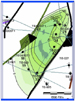
Fault Block 10/11 is situated in the
western portion of the field, which, at I60 time, was characterized by
an estuarine setting where extensive laminated sandstones were deposited
in an overbank setting. These laminated sandstones are connected to the
channel sandstones Fault Block 54/99 is situated in the eastern portion of the field, which, at I60 time, was inland of the estuarine setting. As such, there are no connected overbank deposits and therefore, no aquifer support, resulting in a recovery efficiency of 30%. Interpreted depositional settings for the two blocks are illustrated in Figure 27.
Hampson, Gary J., John A. Howell, and Stephen S. Flint, 1999, A sedimentological and sequence stratigraphic re-interpretation of the Upper Cretaceous Prairie Canyon Member ("Mancos B") and associated strata, Book Cliffs area, Utah, U.S.A.: Journal of Sedimentary Research, Section B: Stratigraphy and Global Studies, v. 69, no. 2, p. 414-433. Karlo, John F., and Robert C. Shoup, (2000), Classification of syndepositional systems and tectonic provinces of the Northern Gulf of Mexico: AAPG Search and Discovery, Search and Discovery Article #30004, http://www.searchanddiscovery.com/documents/karlo/index.htm. Madon, Mazlan B. Hj., 1999, Geological setting of Sarawak (Chapter 12) in The Petroleum Geology and Resources of Malaysia, Mansor, M.I. ed.: Petroliam Nasional Berhad (Petronas), Kuala Lumpur, Malaysia. Madon, Mazlan B. Hj., and Peter Abolins, 1999, Balingian Province (Chapter 14) in The Petroleum Geology and Resources of Malaysia, Mansor, M.I. ed.: Petroliam Nasional Berhad (Petronas), Kuala Lumpur, Malaysia. Miall, Andrew D., and Mohamud Arush, 2001, The Castlegate Sandstone of the Book Cliffs, Utah: Sequence stratigraphy, paleogeography, and tectonic controls: Journal of Sedimentary Research, Section B: Stratigraphy and Global Studies, v. 71, no. 4, p. 537-548. Sarawak State Department of Irrigation and Drainage, 2005, 9th and 10th Floor, Wisma Saberkas, Jalan Tun Abang Haji Openg, Kuching Sarawak. http://www.did.sarawak.gov.my/papt/project/maps_htm/bint.html . Swinburn, P., H. Burgisser, and Jamius Yassin, 1994, Hydrocarbon Charge Modeling, Balingian Province, Sarawak Malaysia (abstract): AAPG International Conference and Exhibition, Kuala Lumpur, Malaysia, 21 – 24 August, 1994, AAPG Bulletin, v.78, no. 13, p. 62. Tearpock, D.J., and R.E. Bishke, (2003), Applied Subsurface Geologic Mapping with Structural Methods, 2nd Edition, Lawrence G. Walker, ed.: Prentice Hall, New Jersey. |