 Click to view article in PDF format.
Illustrated Summary of Compartments / Pressure Regimes in Selected North American Basins: Part 3—Rocky Mountains, Western Canada, and Alaska
By
David E. Powley1
Search and Discovery Article #60011 (2007)
Posted February 17, 2007
*Compiled from slides prepared by the author for his numerous presentations about the subject of compartments and pressure regimes, for which he was pioneer, advocate, and mentor.
1Deceased October 29, 2006. Consultant after retirement from Amoco Production Company.
|
|
Location Map
Denver
|

|
|
Figure 2. Schematic cross-section,
Denver |

|
|
|
|
|

San Juan ![]() Basin
Basin![]()
|
|
Figure 5. Structure map, San Juan |
|
|
Figure 6. Pressure/depth profiles, for
western flank of San Juan |

Uinta ![]() Basin
Basin![]()
|
|
|
|
|
Figure 8. Generalized cross-section of
Uinta |

Southwestern and Central Wyoming
|
|
Figure 9. Map of Red Desert and Washakie basins, showing general area of “tight formations gas.” Inset (after Shaughnessy and Butcher, 1974) shows generalized line of cross-section (in Figure 10), northwest of the area of the larger map. |
|
|
Figure 10. Generalized cross-section, Big Piney / La Barge through Pinedale to Wind River Range. |
|
|
Figure 11. Generalized cross-section,
Wind River |


Powder River ![]() Basin
Basin![]()
|
|
Figure 12. Structure map, Powder River
|
|
|
Figure 13. Southwest-northeast schematic
cross-section, Power River |
|
|
Figure 14. Map of Powder River |
|
|
Figure 15. Map of Powder River |
|
|
Figure 16. Detail map for extents of
underpressured and overpressured Lower Cretaceous formations,
Powder River |
|
|
Figure 17. Salinity, pressure
compartments, and thickness of Muddy Sandstone, northeast Powder
River |


Big Horn
![]() Basin
Basin![]() and South- Central Montana
and South- Central Montana
|
|
Figure 18. Pressure distribution,
Tensleep Sandstone, Big Horn |
|
|
Figure 19. Structure map, Phosphoria
Formation, Big Horn |
|
|
|
|
|
Figure 21. Tectonic elements, south-central Montana, as location map for Dry Creek field in cross-section in Figure 22. |
|
|


Williston ![]() Basin
Basin![]()
|
|
Figure 23. Pre-Devonian paleogeologic map, Rocky Mountains and environs (after Loucks, 1977). |
|
|
Figure 24. Pre-Upper Devonian paleogeologic map, Rocky Mountains and environs (after Loucks, 1977). |
|
|
Figure 25. Generalized stratigraphic
chart, Williston |
|
|
Figure 26. Structure map, on base of
Mississippian, Williston |
|
|
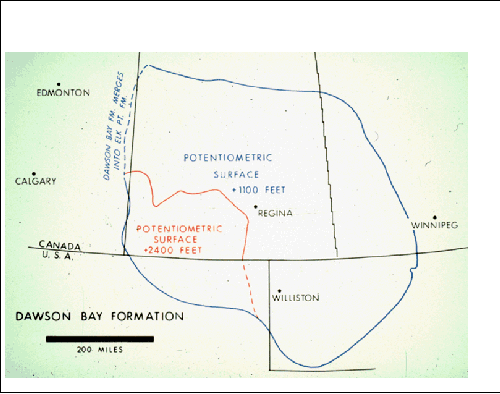
Figure 27. Map of potentiometric surfaces, Devonian Dawson Bay Formation. |
|
|
|
|
|
|
|
|
|
|
|
|
|
|
Click to view in sequence maps of potentiometric surfaces (Figures 27, 28, 29, 32) |
|
|


|
|
Figure 34. Map of Western Canadian regions with fluid compartments. |
|
|
|
|
|
|
|
|
Figure 37. Generalized cross-section,
Beaufort |

|
|
Figure 38. Cook Inlet |
|
|
Figure 39. Generalized cross-section of
Cook Inlet |
|
|
Figure 40. Map of Copper River sedimentary province, where cross-section in Figure 41 is located. |
|
|
Figure 41. Generalized cross-section,
Copper River |


References
Bayne, C.K.; and J.R. Ward, 1974, Geology and hydrology of Rice County, central Kansas: Kansas Geological Survey Bulletin, no. 206, pt. 3, 17 p.
Bayne, C. K., P.C. Franks, and W. Ives, Jr., 1971, Geology and ground-water resources of Ellsworth County, Central Kansas: Kansas Geological Survey Bulletin, no. 201, 84 p.
Darton, N. H. (1896) Preliminary report on artesian waters of a portion of the Dakotas. 17th Annual Rept., U. S. Geological Survey, v. p. 609-694.
Leonard, A.R., and D.W. Berry, 1961, Geology and ground-water resources of southern Ellis County and parts of Trego and Rush counties, Kansas: Kansas Geological Survey Bulletin 149, 156 p.
Loucks, Gerald G., 1977, Geologic History of the Devonian Northern Alberta to Southwest Arizona, in Rocky Mountain Thrust Belt Geology and Resources: WGA 29th Annual Field Conference Guidebook, p. 119-134
McNellis, J.M., 1973, Geology and ground-water resources of Rush County, central Kansas: Kansas Geological Survey Bulletin, no. 207, 45 p.
Meissner, F.F., 1978, Patterns of source-rock maturity in non-marine source rocks of some typical western interior basins in non-marine Tertiary and Upper Cretaceous source rocks and the occurrence of oil and gas in the west central U.S.: Rocky Mountain Association of Geologists Continuing Education Notes, unpaginated.
Paterson, D.F., 1971, The stratigraphy of the Winnipeg Formation: Saskatchewan Department of Mineral Resources, Report, v. 140, 57 p.
Rice, D.D., 1983, Relation of natural gas composition to
thermal maturity and source rock type in San Juan ![]() Basin
Basin![]() , northwestern
New Mexico and southwestern Colorado: AAPG Bulletin, v. 67, p.
1199-1218.
, northwestern
New Mexico and southwestern Colorado: AAPG Bulletin, v. 67, p.
1199-1218.
St. John, Bill, A.W. Bally, and H.D. Klemme, 1984, Sedimentary provinces of the world – hydrocarbon productive and nonproductive (map with booklet): AAPG.
Shaughnessy, J., and R.H. Butcher, 1974, Geology of Wagon Wheel nuclear stimulation project, Pinedale field, Wyoming: AAPG Bulletin, v. 58, p. 2250-2259.
Smith, R.D., 1984, Gas reserves and production
performance of the Elmworth/Wapiti area of the Deep ![]() Basin
Basin![]() , in
Elmworth: Case Study of a Deep
, in
Elmworth: Case Study of a Deep ![]() Basin
Basin![]() Gas Field: AAPG Memoir 38, p.
153-172.
Gas Field: AAPG Memoir 38, p.
153-172.
Swenson, Frank A., 1968,
New theory of
recharge to the artesian ![]() basin
basin![]() of the Dakotas: GSA Bulletin, v. 79, p.
163-182. Also, Swenson, Frank A., 1968,
Recharge and movement of water in the Artesian
of the Dakotas: GSA Bulletin, v. 79, p.
163-182. Also, Swenson, Frank A., 1968,
Recharge and movement of water in the Artesian ![]() Basin
Basin![]() of the Dakotas,
in Black Hills Area: South Dakota, Montana, Wyoming: WGA 20th Field
Conference Guidebook, p. 199-207
of the Dakotas,
in Black Hills Area: South Dakota, Montana, Wyoming: WGA 20th Field
Conference Guidebook, p. 199-207