Click to view article in PDF format.
Paleozoic Petroleum Systems of the Canning Basin, Western Australia: A review*
By
K.A.R. Ghori1 and P.W. Haines1
Search and Discovery Article #10121 (2007)
Posted February 3, 2007
*Adapted from extended abstract prepared for presentation at AAPG 2006 International Conference and Exhibition, Perth, Australia, November 5-8, 2006
1Department of Industry and Resources, Perth
Productivity of Paleozoic petroleum systems depends on timing (Paleozoic–Cenozoic) and preservation (sub-suprasalt) of charge, as exemplified by supergiant, giant, and small oil and gas fields within the Paleozoic basins of North America, North Africa, North Caspian, and the Canning Basin. Like other Paleozoic basins, one of the major exploration risks in the underexplored Paleozoic succession of the Canning Basin is the timing of charge and its preservation during a complex tectonic history. This review covers Paleozoic petroleum systems of the Canning Basin and reconstructs petroleum charge history at:
-
Acacia 1 and 2 on the Barbwire Terrace,
-
Kidson 1 within the Kidson Sub-basin,
-
Willara 1 within the Willara Sub-basin, and
-
Yulleroo 1 within the Fitzroy Trough.
We estimate the timing of charge based on new data (Ghori and Haines, 2006) generated to supplement published and unpublished open-file information.
|
|
Discussion
Figure 1 shows the
geographic distribution of oil and gas within the Canning Basin. Subsalt
Ordovician-sourced oil has been recovered in Cudalgarra 1, Dodonea 1,
Edgar Range 1, Great Sandy 1, Leo 1, Percival 1, Pictor 1 and 2, and
Solanum 1. Suprasalt Upper Devonian-sourced oil is producing from the
Blina field, and oil shows are present in Boronia 1, Ellendale 1, and
Janpam 1. Suprasalt Lower Carboniferous-sourced oil is producing at the
Boundary, Lloyd, Sundown, West Kora, and West Terrace fields, and a gas
accumulation is present at The depositional and erosional history of the Canning Basin commenced with extension and rapid subsidence in the Early Ordovician, followed by four major and several minor phases of deposition and erosion that were responsible for evolution and preservation of at least three petroleum systems: Ordovician, Devonian, and Permian. Major tectonic events responsible for the depositional and erosional histories of the basin include the: · Samphire Marsh extension preceding Ordovician to Silurian deposition, · Devonian Prices Creek Compression prior to Devonian to Early Carboniferous deposition, · Carboniferous Meda transpression before Early Carboniferous to Early Triassic deposition, · Triassic–Jurassic Fitzroy transpression preceding Jurassic to Early Cretaceous deposition, and finally Jurassic–Cretaceous extension.
Figure 2b summarizes source-rock-generating potential and measured maturity from new and open-file data. These indicate the presence of organic-rich, oil-prone source-rock intervals within the Ordovician, Devonian, Carboniferous, and Permian, with source-rock richness and oil-proneness generally decreasing from Ordovician to Permian. The interpretation of over 5968 open-file total organic carbon content (TOC) from 138 wells and 1762 Rock-Eval pyrolysis analyses from 109 wells indicate that most of the analyses are either not from source rock intervals, or were contaminated by migrating oil or during drilling operations. Of these TOC and Rock-Eval data, only 106 samples from 37 wells are interpreted as reliable and most of these are from the Ordovician Goldwyer and Bongabinni Formations. These formations contain the richest oil-prone source rocks in the basin, with the richest analyses in each unit from wells on the Barbwire Terrace and Admiral Bay Fault Zone, respectively. Our new spot check analyses include 73 TOC, 26 Rock-Eval pyrolysis, 8 extract analyses for source rock potential, and 30 organic petrological analyses for source maturity.
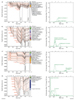
Figure 3 displays
geothermal history and time of charge as a function of petroleum
generation rate at Acacia 1 and 2, Kidson 1, Willara 1, and Yulleroo 1
well locations. The geothermal history, as a function of
The source maturation history at Acacia 1 and
2 on the Barbwire Terrace is constrained by two paleothermal episodes of
cooling from the
At Kidson 1 within the Kidson Sub-basin, three
paleothermal cooling episodes from
For Willara 1 within the Willara Sub-basin,
only one paleothermal episode is recognized for cooling from
At Yulleroo 1 within the Fitzroy Trough, three
paleothermal episodes involving cooling from To evaluate the oil occurrences within reservoir lithologies, 100 potential reservoir rock samples from Acacia 1, Dodonea 1 and 2, Looma 1, White Hills 1, and Yulleroo 1 were analyzed using new techniques that measure Quantitative Grain Fluorescence (QGF) and Quantitative Grain Fluorescence-Extract (QGF-E). These are extremely sensitive in determining the presence of microscopic amounts of oil in reservoir rocks and migration pathways. From QGF-E intensity, depth profiles, and spectral characteristics, Liu and Fenton (2005) recognized several intervals representing either residual reservoired oil or migration pathways in all of these wells. This initial reservoir evaluation, though tentative at this stage, indicates generation and migration of petroleum in these areas and provides incentives for further studies.
ConclusionThis review concludes that oil and gas is geographically and stratigraphically widespread, the timing of petroleum charge varies greatly across the basin, and the quantity and quality of existing source-rock evaluation data for the Willara and Kidson Sub-basins are limited for determining source-rock distribution and charge volume risks. The timing of charge for Ordovician source rocks varies from Early Permian in Kidson 1 to Early Jurassic in Acacia 1 and 2. For Devonian source rocks, it varies from Early Carboniferous in Yulleroo 1, where gas was recovered, to Early Jurassic in Kidson 1. The exploration history of the underexplored Canning Basin shows a direct correlation between drilling activity and discoveries, with peak exploration drilling and discoveries made during the 1980s (Figure 4). The low level of exploration and wide geographic and stratigraphic distribution of oil and gas demonstrate the high potential for significant new oil discoveries. However, this requires further systematic studies of key risk factors in different tectonic units, including source (Gregory, Kidson, and Willara sub-basins), reservoir (subsalt plays) and seal (suprasalt plays) distribution and quality, timing of trap formation versus generation - accumulation (Gregory Sub-basin), and its preservation (Fitzroy Trough).
ReferencesBradshaw, M. T., J. Bradshaw, A. P. Murray, L. Needham, L. Spencer, R. E. Summons, J. Wilmot, and S. Winn, 1994, Petroleum systems in West Australian basins, in P. G. Purcell and R. R. Purcell, eds., The Sedimentary Basins of Western Australia: Proceedings of Western Australian Basins Symposium, Perth, Western Australia, 1994, p. 93–118. Duddy, I. R., M. E. Moore, and C. O’Brien, 2005, Thermal history reconstruction in five Canning Basin wells: Acacia-1, Acacia-2, Kidson-1, Willara-1 & Yulleroo-1, based on apatite fission track analysis (AFTA®), data report, GEOTRACK Report #937: Western Australia Geological Survey, Petroleum Exploration Report, G31772 A1 (unpublished). Ghori, K.A.R., and P.W. Haines, 2006, Petroleum geochemistry of the Canning Basin, Western Australia: basic analytical data 2004–05: Western Australia Geological Survey, Record 2006/7, 66 p. Liu, K., and S. Fenton, 2005, Preliminary QFG/QFG-E data transmission to DoIR WA: analysis of samples from Acacia-1, Dodonea-1 & 2, Looma-1, White Hills-1, and Yulleroo-1, Canning Basin: Western Australia Geological Survey, Petroleum Exploration Report, G31778 A1 (unpublished).
|