The Upper Devonian
Rhinestreet ![]() Shale
Shale![]() : An Unconventional Fractured Reservoir in Western New York
State*
: An Unconventional Fractured Reservoir in Western New York
State*
By
Gary G. Lash1
Search and Discovery Article #10108 (2006)
Posted August 10, 2006
*Oral presentation at AAPG Annual Convention, Houston, Texas, April 9-12, 2006
![]() Click to view
presentation in PDF format (5.9 MB).
Click to view
presentation in PDF format (5.9 MB).
1SUNY-Fredonia, Fredonia, NY ([email protected])
Abstract
The Upper Devonian
Rhinestreet ![]() Shale
Shale![]() of western New York State comprises a sequence of finely
laminated, low-permeability, organic-rich
of western New York State comprises a sequence of finely
laminated, low-permeability, organic-rich ![]() shale
shale![]() and thin intervals of gray
and thin intervals of gray ![]() shale
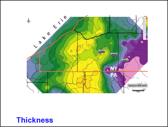
shale![]() and concretionary limestone. The Rhinestreet thickens from ~54 m in exposure
along the Lake Erie shoreline to >100 m near the Pennsylvania-New York border
where its burial depth >1100 m. Total organic carbon content of the Rhinestreet
along the lake shore attains a maximum of 8% and appears to remain high to the
south in the subsurface, based on the analysis of gamma-ray and bulk-density
logs. To the east, however, the thickness of the organic-rich interval decreases
as siltstone and organic-lean gray
and concretionary limestone. The Rhinestreet thickens from ~54 m in exposure
along the Lake Erie shoreline to >100 m near the Pennsylvania-New York border
where its burial depth >1100 m. Total organic carbon content of the Rhinestreet
along the lake shore attains a maximum of 8% and appears to remain high to the
south in the subsurface, based on the analysis of gamma-ray and bulk-density
logs. To the east, however, the thickness of the organic-rich interval decreases
as siltstone and organic-lean gray ![]() shale
shale![]() become more abundant. Measured
vitrinite reflectance (0.76%) and Rock-Eval Tmax (443o C) values
place the exposed Rhinestreet
become more abundant. Measured
vitrinite reflectance (0.76%) and Rock-Eval Tmax (443o C) values
place the exposed Rhinestreet ![]() shale
shale![]() squarely within the oil window. The
Rhinestreet carries several sets of vertical joints interpreted to have formed
as
squarely within the oil window. The
Rhinestreet carries several sets of vertical joints interpreted to have formed
as ![]() gas
gas![]() -driven natural hydraulic fractures during Paleozoic catagenesis. The
joints, open in outcrop, are likely closed at depth under progressively higher
confining pressure. Exceptions to this may be those joints oriented subparallel
to the contemporary maximum horizontal stress field (ENE). Some organic-rich
clay layers carry horizontal µm-scale microcracks, most of which are filled with
bitumen, thereby contributing to the low permeability of these rocks. However,
in those areas of the basin where the Rhinestreet may have entered the
-driven natural hydraulic fractures during Paleozoic catagenesis. The
joints, open in outcrop, are likely closed at depth under progressively higher
confining pressure. Exceptions to this may be those joints oriented subparallel
to the contemporary maximum horizontal stress field (ENE). Some organic-rich
clay layers carry horizontal µm-scale microcracks, most of which are filled with
bitumen, thereby contributing to the low permeability of these rocks. However,
in those areas of the basin where the Rhinestreet may have entered the ![]() gas
gas![]() window, cracking of the bitumen to
window, cracking of the bitumen to ![]() gas
gas![]() would have led to enhanced storage of
free
would have led to enhanced storage of
free ![]() gas
gas![]() . The great unknown, then, remains the level of thermal maturity of the
Rhinestreet
. The great unknown, then, remains the level of thermal maturity of the
Rhinestreet ![]() Shale
Shale![]() in the subsurface to the south and east of Lake Erie.
in the subsurface to the south and east of Lake Erie.
Selected Figures
|
|
Location map, showing outcrop belt of West Falls
Formation, the lowermost unit of which is the Rhinestreet |
|
|
|
|
|
Map of Rhinestreet |
|
|
|
|
|
|
|
|
|
|
|
Map of ratio of resistivity: Rhinestreet |


