Honoring Uncertainty in Mapping and Interpreting Large Volumes of Digital Spatial Data*
By
John D. Grace1
Search and Discovery Article #40197 (2006)
Posted July 3, 2006
*Oral presentation at AAPG Annual Convention, Houston, Texas, April 9-12, 2006
![]() Click to view presentation in PDF format (0.7 mb).
Click to view presentation in PDF format (0.7 mb).
1Earth Science Associates, Long Beach, CA ([email protected])
Abstract
The development of very large digital collections of spatial oil and gas data has permitted the easy extraction of information on individual variables (e.g., depth to top of a unit) or spatial interaction between variables (e.g., sediment accumulation rate and pore pressure). Yet improving access to digital data and the ease of mapping software have often created a confidence in the results that are justified neither by the underlying data nor the (usually deterministic) gridding and contouring algorithms applied to them.
Geostatistical
techniques afford an opportunity to reflect not only the anticipated value of a
variable in space, but to estimate the probability of its occurrence and
confidence intervals surrounding the estimate. A simple procedure is introduced
for creation of masks. Their purpose is to eliminate map areas where confidence
in the estimated surface falls below a threshold and to characterize the
certainty for the remaining, mapped area. Estimated probabilities associated
with individual surfaces in a multi-layer analysis can be consistently
propagated through to final result ![]() maps
maps![]() .
.
Systematic
inclusion of uncertainty in mapping and spatial analysis is critical where risk
arising from errors in assumptions is an explicit part of decision making. The
procedure is applied within a geographic information system (GIS), the most
common tool used for manipulation and analysis of large, digital, spatial data
stores. Illustrations are based on very large data bases covering geologic and
engineering variables from the offshore ![]() Gulf
Gulf![]() of
of ![]() Mexico
Mexico![]() .
.
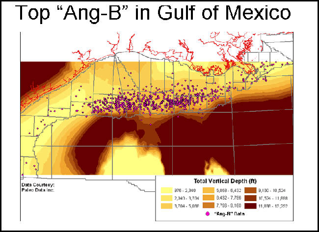
Click to view
in sequence the following ![]() maps
maps![]() prepared for
prepared for ![]() example
example![]() : Mapping depth to “Ang-B” in
: Mapping depth to “Ang-B” in
![]() Gulf
Gulf![]() of
of ![]() Mexico
Mexico![]() (Top of “Ang-B”, Prediction standard error, Mask map where
error ≥ 1103, and Error-clipped “Ang-B” depth map)
(Top of “Ang-B”, Prediction standard error, Mask map where
error ≥ 1103, and Error-clipped “Ang-B” depth map)