|
uFigure
captions
uBasin
systems
u Seals Seals & compartments
uReference
uFigure
captions
uBasin
systems
uSeals
& compartments
uReference
uFigure
captions
uBasin
systems
uSeals
& compartments
uReference
uFigure
captions
uBasin
systems
uSeals
& compartments
uReference
uFigure
captions
uBasin
systems
uSeals
& compartments
uReference
uFigure
captions
uBasin
systems
uSeals
& compartments
uReference
uFigure
captions
uBasin
systems
uSeals
& compartments
uReference
uFigure
captions
uBasin
systems
uSeals
& compartments
uReference
|
Figure Captions
|
 |
Figure 1. Two hydraulic systems
(hydrodynamic and hydrostatic) in deep sedimentary basin. |
|
 |
Figure 2. Two pressure regimes in deep
sedimentary basin. |
|
 |
Figure 3. Abnormal pressure regime in
deep part of basin between two normal-pressure regimes. |
|
 |
Figure 4. Pressure/depth profile, Beaver
Creek Field, Wyoming, showing section with abnormal pressure
between two normally pressured sections. |
|
 |
Figure 5. The buried bottle model of a
fluid compartment. |
|
 |
Figure 6. Normal pressures between
overlying overpressures and underlying underpressures. |
|
 |
Figure 7. Pressure/depth profile, Ernei
Dome, Romania, showing upper seal of compartment with normal
pressure gradient (after Stanescu et al., 1969). |
|
 |
Figure 8. Pressure/depth profile, Frigg
Field, offshore Norway and U.K., showing lower fluid compartment
with near normal pressure gradient. |
|
 |
Figure 9. Pressure/depth profile,
Lanywa-Chauk Field, Myanmar (Burma), with seal showing 2800 psi
differential pressure across 600 feet of shale. |
|
 |
Figure 10. Pressure/depth profile,
Fordoche Field, Louisiana, with Sparta sand compartment between
two shale seals and the Wilcox below the lower seal. |
|
 |
Figure 11. Pressure/depth profile,
Ekofisk and nearby fields, offshore Norway, showing two fluid
compartments. |
|
 |
Figure 12. Pressure/elevation profile,
northern Ardmore Basin, with normal pressure gradients above and
below seal. |
|
 |
Figure 13. Sonic log responses in shale,
Shell West Foreland No. 1, Alaska, and pressure/elevation profile,
West Foreland, Middle Ground Shoal, Granite Point, and Cook
Inlet fields, Alaska, with linear transition in pressures in
seal. |
|
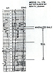 |
Figure 14. Log, Amoco No. 1 S.L. 11736,
Iberia Parish, Louisiana, with mineralized shale associated with
seal. |
Return to top.
In
most deep sedimentary basins in the world there is a layered arrangement
of at least two superimposed hydraulic systems (Figures
1 and 2). The
shallowest hydraulic system can extend to great depths; however in many
basins it extends from the surface down to about 10,000 feet (greatest
historical depth of burial) in normal geothermal gradient basins and to
slightly greater depths in cool basins. There are a few remarkable
deviations, like the central North Sea Basin, the South Papua Basin, the
outer Gulf of Mexico and the Canadian Arctic Basin where the base of the
shallow system has apparently never been buried more than about 4000 to
6000 feet.
The
shallow hydraulic systems are basinwide in extent and exhibit normal
pressures. The pore water apparently is free to migrate; however, the
usual rate of movement, below the uppermost few hundred feet, is so slow
that motion is surmised rather than detected. Stable isotope ratios of
dissolved solids and gases appear to indicate widespread invasion of the
shallow hydraulic system by meteoric water in only a few basins.
The
deeper hydraulic systems usually are not basinwide in extent and exhibit
abnormal pressures. They generally consist of a layer of individual
fluid compartments which are sealed off from each other and from the
overlying system. In some basins, mainly in the onshore U.S., there is
an even deeper, near normally pressured noncompartmented section
(Figures 3 and 4).
The compartmented layer in those basins generally is in the sequence of
rocks which were deposited during the period of most rapid deposition.
The underlying noncompartmented layer, where present, usually is in
pre-basin shelf deposits and basement rock. The uppermost
noncompartmented layer usually is in rocks which were deposited during
the slowing rate of deposition late stage in basin filling.
The
individual compartments in the compartmented layer are like huge
bottles. Each one has a thin, essentially impermeable, outer seal and an
internal volume which exhibits effective internal hydraulic
communication. The rate of increase in pressure with increasing depth
within the internal volume is in direct accordance with the density of
the internal fluids (Figure 5). The fluid
pressures in the internal volume may be greater than, equal to, or less
than the pressures in the fluids in the rocks outside of the seal. The
magnitude of the internal fluid pressure is dependent on how much of the
weight of the superincumbent rock column is borne by the fluids in the
enclosed body and how much of the weight is borne by the rock matrix in
the enclosed body. The fluid pressure below the top seal at the
shallowest point in the enclosed rock body can range from zero, where
the rock matrix bears all of the weight of the superincumbent rock, to
about 1 psi/foot thickness of overlying rock if the enclosed rock matrix
bears none of the weight of the superincumbent rock and water load.
The
individual compartments in the compartmented layer may be very
extensive, as in some of the Rocky Mountains basins, or may be only a
few miles across, as in the Gulf Coast Basin. The pressures within the
compartments generally are overpressured or underpressured relative to
the pressures in both the shallower and deeper hydraulic systems (Figure
6). The compartmented hydraulic systems in currently sinking basins
are almost universally overpressured and are underpressured in many
onshore basins undergoing erosion. The principal sources of
overpressures appear to be thermal expansion of confined fluids and the
generation of petroleum during continued sinking, and the principal
source of underpressures appears to be thermal contraction of confined
fluids as buried rocks cool during continued uplift and erosion at the
surface. Thus, it appears that the compartments have an amazing
longevity as they undergo a continuum from overpressures through normal
appearing pressures to underpressures as their host basins progress from
deposition, to quiescence, to basin uplift and erosion.
In
those basins with three layers of hydraulic systems, the seal between
the middle compartmented layer and the underlying noncompartmented layer
usually follows a single stratigraphic horizon. For instance, the basal
seal of the compartmented section in the central Powder River Basin
appears everywhere to be within the thin Cretaceous Fuson shale.
However, in many basins, the top seal of the compartmented layer is more
complicated. (1) It tends to follow an irregular
sands-over-massive-shale boundary in the Gulf Coast and Niger Delta
basins; (2) it is within thin evaporites in many onshore European and
southwestern U.S. basins; and (3) it occurs as horizontal or gently
dipping planes which cut indiscriminately across structures, facies,
formations, and geological time horizons in the Alaska North Slope
Basin, in the northern Cook Inlet Basin, in the Alberta Basin, in the
Anadarko Basin, in the North Sea Basin, and in many Rocky Mountains
basins (Figure 3). Those top seals which do
not follow a specific stratigraphic horizon generally are restricted to
clastics-dominated sections. Planar seals may occur on the top, bottom,
or within compartments.
The
planar-topped, compartmented sections are almost universally in basins
which are older than the basins in which the compartmented sections
exhibit much top surface irregularity. Thus, it appears that there is
some process in nature whereby the top seals of compartments in clastics-dominated
sections can smooth themselves over time. The leveling process may be
quite rapid because the tops of the two principal fluid compartments in
the central North Sea Basin are horizontal over distances in excess of
100 miles despite the recent salt-induced structure development in the
area.
Return to top.
Seals and Compartments
Recognition of the layered arrangement of hydraulic systems generally is
quite easy. Only a few widely spaced, well-documented deep wells with
several pressure tests run over perforated intervals or several pressure
readings from repeat formation testers in scattered wells generally are
sufficient to outline the overall arrangement of hydraulic systems in
each basin. Pressure/depth profiles are remarkably similar in most deep
basins in the world (Figures 7,
8, 9,
10, 11, &
12). The similarity suggests that the
formation of seal-bounded fluid compartments is part of normal basin
development.
Seals
are particularly annoying to work with because they do not have
consistent lithologic properties other than extremely low
across-the-seal permeability. In the absence of unique lithologic
properties, recognition must be accomplished from indirect evidence,
such as well log indicators, measured pressures in local reservoirs
encased in seal rock, and often only from the requirement that they must
be there separating reservoirs which, from measured pressure data, are
obviously hydraulically separated from each other. Seals may have thin
internal permeable rock layers (like bubbles in the glass of glass
bottles), which contain water or oil and gas pools. The transition of
pressures across the total thickness of top seals in clastic rocks is
linear with increasing depth wherever data have been obtained (Figure
13). Too few data have been accumulated to determine the patterns of
pressures within lateral seals or within basal seals. The overall rate
of pressure change across seals in sha1e has been observed to be as
great as 15 psi/ft and 25 psi/ft in seals in sandstone.
In some
areas, seals may be recognized by calcite and/or silica mineralization
within the seals or in the lower pressured rocks exterior to the seals,
probably resultant from dissolved minerals being precipitated as water
seeps through the seals. The mineral infi1l of porosity and fractures
may be so readily recognizable that it becomes an identifier of present
or past seals. For instance, calcite infill is so ubiquitous within
seals and in adjacent beds in southwestern Louisiana that it has been
given the name “Al's Cap,” named for Al Boatman, a local geologist, who
first publicly drew attention to the phenomenon there. Silica infill may
be recognizable on the basis of drastically reduced rates of drilling
penetration across a seal. For instance, it took 24 hours to cut a 60-ft
core in a silica-enriched seal in chalk in the Shell-Esso 30/6-2
well in the North Sea. Chalk normally cores very rapidly, unless the bit
becomes clogged. Several well log interpretation techniques have been
developed to recognize the changes in pressures across seals and to
recognize the mineralized rocks associated with seals (Figure
14).
Top
seals in clastics-dominated sections range in thickness from 150 feet to
over 3000 feet; however, the majority are uniformly near 600 feet. Seals
in carbonate-evaporite sections are generally somewhat thinner; in fact,
some salt and anhydrite beds as thin as 10 feet form effective seals. An
example of the latter is the Devonian Davidson evaporite, which, except
for a small area in central Saskatchewan, is about 20 feet thick but
forms a regional seal over almost the entire extent of the Williston
Basin.
Lateral
seals appear to be generally vertical or very nearly vertical. They
range in width from less than 1/8 of a mile (within the distance
between wells on 10-acre spacing) to about six miles, with the majority
being 1/8 of a mile or less in width. They tend to be quite
straight, which suggests that they may tend to follow fault trends.
There has not been any satisfactory suggested geochemical mechanisms
which could create impermeable walls over thousands of feet of vertical
extent through rocks of many lithologies. Where wells have penetrated
lateral seals, the rocks have generally been found to be slightly
fractured and the fractures infilled with calcite and/or silica. In a
few localities, some of the fractures are locally open and can
yield limited oil and gas production. While lateral seals are almost
always nearly vertical, continuous planes, there are a few remarkable
cases of breaks in seal continuity where individual permeable
rock layers extend in hydraulic continuity from a compartment into a
neighboring compartment. Those tongues are of particular interest to
exploration geologists because they frequently contain oil and gas
pools.
The
rocks in the internal volumes within the compartments, like the seals,
do not have a unique lithology. The most unique property is the
pervasiveness of fractures observed in cores and indirectly indicated by
the apparent hydraulic continuity (i.e., reservoir to reservoir
continuity of interval pressure-depth profiles) within the internal
volumes. A few authors, most notably Narr and Currie (1982), have
attempted to explain a genetic mechanism for the fractures; however,
none of the explanations to date have been particularly convincing. The
fractures in underpressured through slightly overpressured Cretaceous
and older rocks are generally nearly closed in most basins; however,
they are generally open enough to cause prominent reductions in overall
interval sonic velocities in overpressured rocks. The fractures are open
enough to take large quantities of drilling mud if the mud columns in
drilling wells are slightly overbalanced in underpressured fluid
compartments in the Hanna Basin and in the deep basin area of the
Alberta Basin. Mud losses start at the base of the top seals in both
areas. The mud will reenter the wellbores if the wells are changed to an
underbalanced state. Most fractures are less than 1 inch long. They
generally extend from pore to pore and tend to separate grains rather
than break across grains.
The
fractures in the internal volume are, in a few areas, open enough to
permit commercial-rate extraction of oil and gas even in the absence of
significant matrix porosity and permeability. However, the distribution
of open fractures is generally not uniform enough to allow field
development without a substantial proportion of dry holes unless the
fracture porosity is augmented with matrix porosity and permeability
within the internal volume rocks. The matrix rocks, in different areas,
may exhibit remarkably different porosity values. For instance,
sandstone porosities are in the 20-35% range in the overpressured
Cretaceous Tuscaloosa sandstone reservoir in the False River Field in
Louisiana and are generally much less than 10% in the Paleozoic Goddard
sandstone reservoir in the Fletcher Field in Oklahoma at approximately
the same depth and pressure.
Fluid
compartments are important in subsurface geology because oil and gas is
trapped in permeable beds where they abut seals, it is trapped within
permeable beds within seals, or, in a few cases, compartments and their
seals are completely filled with oil or gas. Fluid compartments
apparently trap oil and gas for very long periods of time and may be
important, from a national resource standpoint, in retaining petroleum
at depths beyond the usual depth range explored to date. Underpressured
fluid compartments probably will become important as sites for disposal
of gas and liquid wastes. oil and gas for very long periods of time and may be
important, from a national resource standpoint, in retaining petroleum
at depths beyond the usual depth range explored to date. Underpressured
fluid compartments probably will become important as sites for disposal
of gas and liquid wastes.
It
would be highly desirable to better understand the subsurface
environment in which fluid compartments are formed and continue to
survive. The purpose of the talk today is to show sufficient hard data
on fluid compartments in several basins around the world to allow the
audience to acquire a balanced “feel” for the phenomena observed.
Stanescu, V.,
C. Carraru, and D. Varvarici, 1969, Abnormal pressure and structure of
the gas bearing reservoirs of some salt domes of the Transylvanian
Depression: Bulletin of the Institute of Petroleum, Geological Gazette,
Bucharest, Romania, v. 17, p. 239-257
Return to top.
|