![]() Click
to article in PDF format.
Click
to article in PDF format.
Applying 3D Seismic to Underexplored Areas in the Uinta Basin*
By
Marc Eckels1, David Suek2, Viola Rawn-Schatzinger3, Virginia Weyland4, and Paul Harrison5
Search and Discovery Article #10097 (2006)
Posted February 6, 2006
*Modified from extended abstract prepared for presentation at AAPG Annual Convention, Calgary, Alberta, June 19-22, 2005
1Wind River Resources Corporation, Roosevelt, UT ([email protected])
2Black Coral LLC, Denver, CO 2
3CDO Technologies/DOE, Tulsa, OK
4U.S. DOE, NETL, Tulsa, OK
5Fall-Line Exploration, Inc., Silverthorne, CO
Historical Background
The Uinta Basin of northeastern Utah has long been a prolific oil and gas producer. Commercial, locally consumed natural gas production began in the basin in 1925 at Ashley Valley field near Vernal. Utah’s first commercial oil production was established from deeper formations in the same field in 1948.
Major oil company exploration efforts in the Uinta Basin commenced shortly after World War II and ultimately succeeded in discovering nearly all of the basin’s significant oil and gas fields by the early 1960s. Prior to the construction of a transportation system for natural gas in the late 1950s and early 1960s, oil was the commodity of primary interest. Even after the pipelines were built, natural gas received little attention because of the weak market and seasonal demand for gas in the Rockies.
Many exploratory wells encountered gas on the rugged south flank of the Uinta Basin during the major company exploration effort. Bar X, Westwater, Fence Canyon, Bryson Canyon, and San Arroyo fields were developed in this area early in the process because gas transportation was available on the Northwest Pipeline system a few miles to the east in Colorado. These fields, and many smaller fields in the area, produced gas from generally long-lived wells in the Cretaceous Dakota Sandstone and Cedar Mountain Formation and the Jurassic Morrison and Entrada formations, although the Entrada tended to produce low Btu gas due to contamination by carbon dioxide.
Although 2D
seismic surveys were conducted throughout the Uinta Basin during the early
exploration effort, no 3D seismic ![]() data
data![]() were acquired until the mid-1990s, when
two small seven-square-mile surveys were conducted in or near existing producing
areas. Vast gas-prospective areas, largely on the south flank of the basin,
received minimal attention from explorationists for many years due to the lack
of oil potential, extremely rugged terrain, poor access to remote locations,
difficult drilling conditions, and poor gas markets.
were acquired until the mid-1990s, when
two small seven-square-mile surveys were conducted in or near existing producing
areas. Vast gas-prospective areas, largely on the south flank of the basin,
received minimal attention from explorationists for many years due to the lack
of oil potential, extremely rugged terrain, poor access to remote locations,
difficult drilling conditions, and poor gas markets.
|
|
North Hill Creek 3D Seismic SurveyA significant and highly prospective portion of the underexplored southern Uinta Basin belongs to the Ute Indian Tribe in the Hill Creek Extension of the Tribe’s Uintah and Ouray Reservation (Figure 1). During 1999, the U.S Department of Energy solicited proposals for projects designed to encourage energy development on Indian reservations. Wind River Resources and the Ute Indian Tribe made a successful grant proposal to the DOE and received cost-share funding for a fifteen-square-mile 3D seismic survey on tribal surface and mineral lands in the Hill Creek Extension. The survey area grew to include a total of twenty-seven square miles, with most of the additional acreage consisting of split-estate lands (tribal surface overlying either state or federal minerals) that included the small Flat Rock oil and gas field, which produced from two of ten prospective geologic formations.
Survey DesignThe North Hill Creek 3D Seismic Survey was the first large-scale exploration-oriented 3D survey conducted in the Uinta Basin. It was designed to delineate the structure and stratigraphy of a portion of the Hill Creek anticline. The Hill Creek anticline had been previously identified in the work of John Osmond, Donald Stone, and others as a subsidiary structure associated with the Garmesa wrench fault zone, located a few miles to the north. This fault forms the north edge of the northwest-plunging Uncompahgre uplift. Although the Hill Creek anticline was noted in many publications and shown on several maps, its exact location and nature were not well understood (Figure 2).
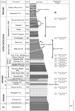
The North Hill Creek 3D survey was designed to image a geologic section
ranging from the Wasatch at a depth of 2,000 ft. to the Entrada at more
than 11,500 ft. (Figure 3). When the project
was conceived, it was believed that the most important objectives would
be shallow Wasatch Formation oil and gas and deeper gas potential in the
Dakota, Cedar Mountain, and Morrison formations. Secondary objectives
included stream-channel
A mixed-source design was chosen due to extremely rough terrain in the
survey area, a 7,500-ft. elevation mesa bounded and dissected by
1,000-ft. deep canyons. The final survey consisted of 81% Vibroseis and
19% dynamite shot-hole sources. The source lines were oriented
northeast-southwest and
Field AcquisitionSurveying for the North Hill Creek 3D Seismic Survey began in September, 2000. WesternGeco started acquisition in late October and concluded work on December 7, 2000. Prior to the start of the survey a zero-offset vertical seismic profile (VSP) was run in an 11,600-ft.-cased hole awaiting completion at a location within the survey area.
|