|
Figure and Table Captions
Return to top.
Recording,
 Processing Processing , and Interpretation , and Interpretation
Shear
waves do not propagate through water; so at sea we must place the
receivers on the seabed. We then rely on mode conversion from P-energy
to S-energy at the water bottom and at other geological interfaces.
These shear waves are then known as "converted shear waves."
Dramatic
improvements in recording hardware and in data processing have brought
multicomponent seismic from the domain of the research lab and academia
to more wide-scale use by explorationists and development geoscientists:
·
Most multicomponent receivers
now in use exhibit good vector fidelity (they respond equally to motion
in any direction) and broadband frequency response.
·
Some receivers, such as I/O's
VectorSeis and Sercel's DSU3, actually are solid-state accelerometers,
where a digital signal is generated directly at the receiver, thereby
eliminating analog instrument noise.
·
Processing algorithms have
matured to the point where prestack time migration of converted shear
waves is part of a typical processing flow. This has made significant
improvements to the quality of the final product.
·
Commercial software (ProMC from
Hampson Russell) is now available to help the interpreter with the task
of correlating and measuring the relative responses from the different
multicomponent modes.
The
primary application of multicomponent seismic has been imaging within
gas clouds or beneath obscuring shallow gas zones. By reasonable
estimate, approximately three-quarters of the industry's 4C surveys have
targeted such geophysical problems. Gas strongly absorbs P-waves, which
propagate through both the rock framework and the fluid. S-waves, on the
other hand, pass almost undiminished, because they propagate only
through the rigidity of the rock framework.
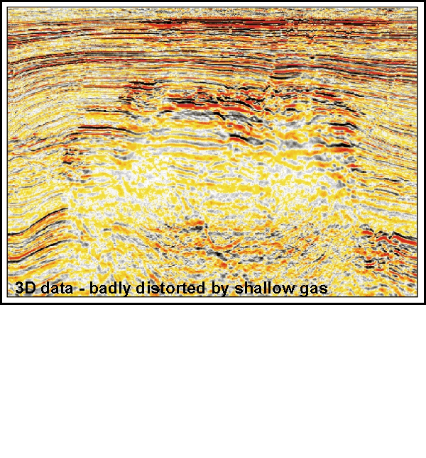
An example
from Indonesia is shown in Figure 1; the
deeper part of the P-wave section is badly degraded by a shallow gas
reservoir, but the PS converted wave section gives a nice crisp image of
the offending shallow gas layer, the local faults, and the underlying
structure.
Geophysicists have had good success with imaging through gas clouds and
shallow gas in cases all over the world. Indeed, a full consensus of
multi-component experts at the 2000 SEG Summer Workshop deemed gas
clouds to be the "slam-dunk" of multicomponent applications.
Table 1 shows that all 65 experts thought
it "very likely" that a survey designed to image through gas would be
successful. While some applications were still thought to be "research
topics," several other applications are clearly mature or maturing
technologies (and we've come quite some way in the four years since
2000).
Low
P-impedance Sands
The second
most important application of multicomponent seismic is the imaging of
low P-impedance sands (Class II AVO) -- and one of the most widely
published examples is from Alba Field in the UK North Sea (Figure
2). In this case, the top of the oil-filled part of the reservoir
has very low P-impedance contrast with the overlying shales. This
hampered the mapping of the turbidite reservoir, which now is believed
to be further complicated by a complex structure of injectite sands.
A 3-D 4C
survey was able to take advantage of the strong shear impedance contrast
at the top of the reservoir and provide a clear picture of the sand
distribution. This had a profound impact on development drilling success
rates and field economics in general.
This
example is not an isolated success story -- several other turbidite
plays have similar petrophysics and are similarly amenable to
converted-wave imaging. This probably includes the Miocene deep gas play
on the Gulf of Mexico Shelf.
Economics
So the
enabling technologies are mature and available. The question then is an
economic one -- does the risked value of the multi-component data exceed
the cost of the survey?
Very
often, the answer is yes. There are several capable crews available, and
competition is generally a good thing. Onshore, a 3-D 3C survey need not
be much more expensive than a normal 3-D survey; given the costs and
uncertainties of permitting, it is often wise to collect the best data
in the initial survey.
Nine-C
surveys require costly oriented-shear sources, which tend to drive the
price up relative to normal 3-D, but the expense may be justified in
some cases. Offshore, a seabed receiver survey will be considerably more
expensive than 3-D streamer, often 5-10 times as much.
However,
for many surveys the expense is well worth it, particularly when the
prize is large. In an area congested by facilities, it may not even be
possible to collect a high quality long-offset streamer survey. A seabed
survey may be necessary for multiple attenuation, or for full azimuths
and long offsets. If two components on the seabed are to be recorded,
one should almost certainly record all four.
Battie, J.E., M. Bennett, and I. Gimse, 2000, 4 Component
seismic – seeing through the haze (abstract, Bali Conference): AAPG
Bulletin,
v. 84, no. 9.
MacLeod, et al., 1999a, EAGE Meeting Abstracts (1999).
MacLeod, M.K.,
R.A. Hanson, and C.R. Bell, 1999b, The Alba Field ocean bottom cable
seismic survey: impact on development: The Leading Edge, v. 18, p.
1306–1312. survey: impact on development: The Leading Edge, v. 18, p.
1306–1312.
Return to top.
|
