|
Figure Captions
Return to top.
The growing
amount of available  3-D 3-D data is one reason an interpreter needs
to employ visualization techniques. On a worldwide basis (excluding
North America), numbers published by the IHS Energy Group in “First
Break” indicate that from 1991 to 2002 the cumulative surface area
covered by 3-D seismic data doubled every 2.5 years. By the end of 2001,
the equivalent surface area of this cumulative seismic data was larger
than the state of Alaska. data is one reason an interpreter needs
to employ visualization techniques. On a worldwide basis (excluding
North America), numbers published by the IHS Energy Group in “First
Break” indicate that from 1991 to 2002 the cumulative surface area
covered by 3-D seismic data doubled every 2.5 years. By the end of 2001,
the equivalent surface area of this cumulative seismic data was larger
than the state of Alaska.
If you
assume that a full stack and three additional attribute volumes (such as
a near-, mid- and far-stack volume) need to be interpreted, then by the
end of 2002 these combined volumes could cover the entire United States.
The speed, efficiency, completeness, and multiple workflows available
from visualization tools are required to keep up with the growing data
volumes. Moore’s Law is yet another reason you need to use
visualization techniques, and continually upgrade your computers and
graphics system. Moore’s Law implies that if you upgrade your
visualization hardware every three years you will catch up on the growth
of the 3-D data volume. Your graphics and computing power will increase
by ~4x, while the data volume has only increased by ~2x.
If your
competitors are using visualization tools and continually upgrading
their hardware and you are not, how much farther behind are you falling?
However, the most compelling reason that you need to use
visualization tools is that if you don’t, you probably will miss
important features of your data volume, such as detailed depositional
patterns and large regional flat spots.
Figure 1 contains 12 sub-images showing
changing depositional patterns. The first sub-image is of the
volume-sculpted package. The other 11 images are proportional (stratal)
slices through this package. Slices (3) through (11) were taken
proportional distances from the top and bottom of the two bounding
surfaces (2) and (12).
The
depositional patterns in the proportional slices are not apparent on
either of the bounding surfaces, nor are they readily apparent in the
volume-rendered sub-volume. Such details are important as they indicate
possible flow boundaries or conduits as well as give clues where other
sands might have been deposited.
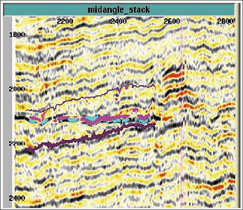
A volume
rendering of the largest amplitudes found in the mid-angle stack over an
undeveloped West Africa field is shown in Figure
2. This is an end-on view of a ~300-square-kilometer survey. The
sands of the field, which are expected to contain in the range of 500
bcfg to 1 tcf gas within the limits of the 3-D survey, are between 2400
to 2600 ms.
The flat
spot at 2100 ms is hard to miss – however, at least seven different
evaluation teams did not identify it as a drilling target. Clearly these
teams did not generate a similar display. Most of these teams
concentrated their efforts on the slightly deeper (250+ ms) objective
known to contain hydrocarbons and believed to be part of a giant
regional stratigraphic trap.
How many of
us don’t have or take the time to explore the volume above or below our
current objective? Do you know what you are missing?
A thick,
volume-rendered, opacity-filtered time-slice around 2100 ms, again just
showing the largest amplitudes, is provided in
Figure 3. The five wells, drilled for the deeper target, missed
hitting the 60-square-kilometer flat spot, even though it covers about
20 percent of the survey. The two wells that clipped the edge of the
flat spot should be investigated for oil shows.
The AVO
nature of this event is illustrated with Figure
4. It is not a “textbook” example of a fluid contact. The “reservoir
sands” are hard to discern on the vertical sections; they do not have
the textbook behavior on either side of the “fluid contact,” and the
contact appears locally to “change phase.” The “contact” also appears to
have some localized “velocity pull down.” However, until the gathers are
evaluated for proper processing and rock property modeling has been
done, a hydrocarbon effect should not be ruled
out.
If the flat spot is a fluid contact, then
optimistic approximations to the reservoir geometry and properties imply
over five billion barrels of oil in place within the limits of the
survey. Figure 3 indicates that the flat spot should extend beyond the
survey limits. If the right visualization tools and workflow were
utilized earlier in the project, slight modifications to two of the
drilled well paths could have allowed testing of this potential
reservoir. So is this a missed billion-barrel field? Only a well will
tell.
For those of you who still don’t think you
need visualization , you might be right, for in the words of Edward
Deming: “It is not necessary to change. Survival is not mandatory.” , you might be right, for in the words of Edward
Deming: “It is not necessary to change. Survival is not mandatory.”
Return to top.
|
 Click to view article as PDF

